Quote:
Originally Posted by Migrant_Coconut

Also, just because SkyTrain can take a "steep" grade doesn't mean it should. Pushing uphill both ways when it doesn't have to wears it out faster and drives up maintenance costs, and that also offsets the $20m/km saved by going elevated over tunneled.
While TransLink is branching out into real estate, I highly doubt that it incentivizes cut and cover or elevated guideways. |
I've pointed out previously that the Broadway Plan elevated comparison is highly misleading, as elevated trains use a 25% contingency fund, rather than the 50% contingency fund.
This is shown in the SLS business case (even though the actual contingency fund is blacked-out, we know the max contingency is 25%.).
This saved contingency mounts to $680M over the entire UBC subway project (taking the project ~$3.2B in total, rather than ~$4B.)
The $20M/km is just going elevated vs bored in
direct construction costs, which is only a
portion of the total contract cost.
https://www2.gov.bc.ca/assets/gov/transp...d-appendices/sls_business_case_final.pdf
Quote:
Originally Posted by Sheba
Yes it is possible to add infill stations - where it makes sense. A station at Boundary would only be about 1km away from Patterson Station and 800m from Joyce Station. Adding one there with those short distances doesn't make a lot of sense.
Yes I'm the one who found that little tidbit. They want people in the Brentwood area to be able to see Central Park.
Exactly. That's why I suspect most Skytrain lines NoF will be primarily underground.
|
It would allow the corner of Boundary and Kingsway from being on the very edge of theose walkable circles to the center of it.
It would also open up land all the way up to Brandon or Price.
It raises the question as to why they're even bothering with that viewcone.
If Vancouver's going to ignore the QE Park viewcone, than Burnaby can ignore its backwards viewcone towards Central Park.
Post-Broadway Plan, the Vancouver viewcones are increasingly irrelevant in terms of being serious hindrances to development, as they're being increasingly ignored or just removed entirely.
Most subway stations outside Vancouver (eg. Toronto) are around 1km away from each other- and 800m is pretty reasonable for Metrotown. Note that the distance between stations in most suburban town centers in Vancouver is 1km to 600m.
The exceptions are Boundary-Kingsway, Imperial (Royal Oak was built where it is because it was cheaper there), 112 Ave in Surrey (difficult station location), Delta Ave (again, expensive curved location), and Cameron Street (expensive inclined location.)
Other stations (Capstan Way, Lincoln, etc.) either are already being built or have provisions to build stations there once development needs it.
'Built up' as in the suburban SFHs that line most of 41st and Willingdon? Really?
Willingdon (well, most of it) 41st, and Hastings are wide enough to have bus lanes across their entire length (and are getting bus priority across their entire corridors.)
At that point, unless you plan on turning the bus lanes back into parking lanes, it raises the question as to why you're bothering going underground when you went through all the effort to make space for transit.
Migrant pointed out shadowing for Broadway, but the suburban town centers generally have very wide setbacks vs Broadway to make room for wide sidewalks.
Also, Evergreen destroyed 20 or so SFHs so it could tunnel underneath the hill down Clark Road to prevent the destruction of the Chines Park Gully.
If we stay under 30 SFHs per 5 or so km of SkyTrain, it should be fine.
Quote:
Originally Posted by Spr0ckets
It's worth noting (as has also been noted previously and as was originally well spotted by Sheba) that part of why that area just north of the tracks and the Telus Boot seems to have such low density compared to Metrotown next door and Joyce Collingwood on the other side is because it sits right were Burnaby has it's singular Viewcone between Brentwood and Central Park.
So that probably limits what developers might want to build there.
I think they should worry more about getting more density around Commercial and Nanaimo stations themselves before worrying about having more density in the region between them that might justify having an additional stop somewhere in between them.
As has been noted many times in the past, the fact that Commercial-Broadway has the low level of density it has around it, for being one of the busiest and most trafficked SKytrain stations and Transit hubs in the entire network, is one of the biggest jokes this side of Nimbyland.
There was a concept proposal not that long ago that was published that suggested or proposed the construction of something like 10 residential towers around Nanaimo station, which,....along with 29 Avenue have really been slow in getting more density and residential built to take advantage of the upzoning they have as transit hubs.
I'm not really sure how far such proposals have gotten along, but seeing as how much difficulty there has been getting the Safeway Towers project off the ground next door at the Commercial-Broadway station, I guess we shouldn't be too surprised.
(and they're not even that big or tall by GVA standards, yet the Nimby's lost their ever-loving minds and lost their sh** over it all. I hear they're now going for taller than originally proposed. Good!!!)
|
Quote:
Originally Posted by FarmerHaight
Since others brought up the 49/41 Skytrain, do you think Burnaby came up with the Metrotown plan as-is with the intention of altering it when the Willingdon or 49/41 Skytrain is built? Because if there are rapid transit stations at Grange/Willingdon and Patterson/Imperial I think Maywood and The Ridge will be ripe for up-zoning.
If what area keeps densifying? Boundary and Kingsway? AFAIK, there isn't a lot of development happening around that intersection.
|
Probably the Metrotown plan gets altered when the Willingdon/41st SkyTrain gets built.
No, because it's on the very edge of the walkable zone of Patterson.
There would have to be towers all the way down to Maywood Street before we're going to see development on the north side of Central Park.
Quote:
Originally Posted by madog222
|
I interpreted it as 41st OR 49th- both of which are major bus routes (49th is actually slightly more used than 41.)
Yeah, that's why I expect 41st to go through Central Park to hit Metrotown.
Which is yet another reason to move the entire park south so it's not dealing with the fact 2 SkyTrain lines intersect it.
Quote:
Originally Posted by Spr0ckets
You're conflating and muddling stuff, somewhat.
Not to mention over-simplifying things.
The affordability situation in Vancouver is nothing like what big American cities like San Fransisco are going through - particularly with regards to the causes.
Vancouver house prices are unaffordable NOT necessarily because there's a paucity of land on which to build new housing - certainly not in Greater Vancouver Area - (as would be the case in places like San Fran and New York), but because for years successive administrations in the various municipalities have badly mismanaged the zoning and housing policies and instead poured fuel into the fire of a runaway housing and real estate market rather than enacting policies that would have slowed it down.
The policies they began to enact only in the last couple of decades, such as upzoning regions close to transit hubs to encourage development around transit areas are policies that other cities that have had more robust transit systems have been enacting since the turn of the last century. And it's stuff that should have been happening from as soon as the Skytrain system went online in the 1980's.
There are other reasons why San Fran's unaffordability situation and housing crisis problem is different from Vancouver's and unique to them (like the presence of the Tech Industry and Silicon Valley that's paid out mega-high salaries fueling the ability of people to pay above market rate in other parts of the US, and thus skew their housing prices, for example. On the other hand, Vancouver's average and median wage and income come nowhere close to matching the standard and cost of living for most people that live here.)
But then again, on the one hand you're arguing that....
And then not long after that you're like,....
So is there a dearth of land and space on which to build on or not?
Or does this paucity only exist for VAncouver but Metrotown is fine for the moment?
Make up your mind.
You're splitting hairs here, and you know it.
Whatever the zoning is, you know darn well you can't develop high density housing or highrise on cemetery zoned land without a rezoning process that would have to upzone it.
The current zoning maxes out any buildings at 1-2 storeys
Same as SFH.
And as you can see from the plan below even the areas in Maywood district just north of Imperial are only zoned for 1-2 storeys.
Which is the same for everything south of Imperial including Ocean View - SFH zoned or not.
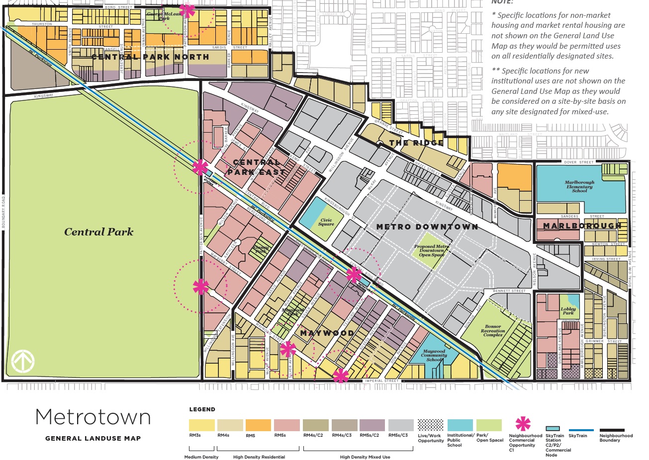
Secondly, Central Park is indeed part of Metrotown "core" per the OCP, but so what?
(the actual "Downtown" designated area is between Beresford to the south and Hazel to the North and between Patterson to the West and Marlborough to the East. See above.)
It's zoned as public park/open space. You can't redevelop high density on it either per the OCP so even your idea of exchanging some cemetary land for parkland still wouldn't fly without a major rejigging of the already established OCP.
And that's not happening either without major public pushback that would likely kill any attempt to do so.
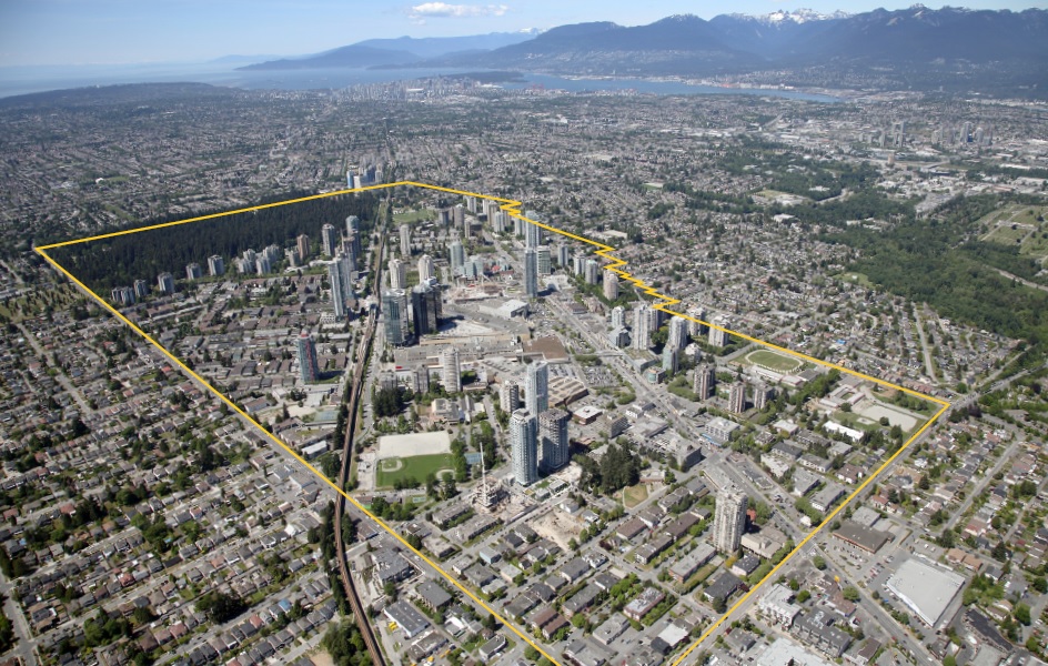
Royal Oak has more riders than Patterson because it's the last stop for quite a distance before you get to Edmonds, and as a result it has a larger collection radius for riders than Patterson does, which is sandwhiched between two bigger hubs (Joyce Collingwood) and one of which is the biggest suburban transit hub in the GVA (Metrotown Station),
So, it's not inconceivable that most riders who even live nearer to Patterson would get off at Metrotown Station (to do some shopping at the mall before walking home) or get on at either Metrotown or Joyce Collingwood (depending on which side they live) rather than at Patterson.
Royal Oak actually has a lot of riders who drive from their homes either from south slope or farther east, park in the area and leave their cars and then get on the skytrain to get to downtown or to other destinations.
That means they get more riders than people who live in the (immediate) area.
But Patterson's ridership won't always be low, since the Patterson area is the area that's currently undergoing most of the redevelopment in Metrotown with three under construction towers, and three more already proposed/accepted and a couple more in planning stages.
Why would they want to do this?
Joyce Collingwood is part of Vancouver City and an entirely different municipality with completely different imperatives that they're subject to.
Again, good luck being part of the administration that proposes turning Central Park land into residential zoning for highrise developments.
It'll never fly politically or otherwise.
It also happens to be the one area in Burnaby that has a viewcone, I believe.
So yeah,....good luck with all of that.
Yes, this is indeed a problem where Brentwood is concerned and, surprise!! surprise!!, that's kind of what happens when you create a town center and residential neighbourhoods out of what used to be Industrial lands.
But I'm still not convinced that the solution to increasing that parkland would be to turn their graveyard or cemetery into a park, when they still have several options in the area and oppoturnities to encourage the development of public park spaces with new developments there. |
Imagine thinking
San Fran has 'good' zoning policies.

Both can be true simultaneously.
Both San Fran and Vancouver have bad zoning policies while also being land-limited, both of which conspire to create high RE prices.
Note that San Fran
still has SFHs 3.5 km away from the city center, despite being part of a much larger Metro area.
This is comparable to the distance from Waterfront and 16th Ave, BTW, and the 'centers' of both their respective downtowns are next to the ocean.
Considering the rate of development in Metrotown, there's still space for the next 30 years, but not after that.
It's kind of the same argument with Downtown and the historical districts, but to a different extent- Downtown/West End sans Broadway have a lot of empty/underutilized lots, probably enough for a decade or two- but growth is still slowing down and limited by the zoning and geographic limitations.
Hence, the Broadway Plan, and the previous, controversial discussion about rezoning the Historical Districts.
The general consensus appears to have been that the development of everything else but Yaletown Warehouse was fine.
It will also probably
take 30 years to get through all the layers of...stuff you'd have to get through to successfully build on a cemetery.
Like getting all the relatives who still have graves there to agree to relocation.
Starting the process earlier means there are less graves to move as relatives die out or decide it's time to let go.
So is it OK to rezone SFH districts ever?
That sounds pretty 'grand bargain-y', and part of the 'bad policies' that led us to this affordability mess in the first place.
Dunno, why would Coquitlam want to join up with Lougheed Center on the opposite side of North Road?
Joyce is also an existing commercial center with density- what Burnaby originally looked for when designating the town centers.
Again,
moving Central Park
south (away from the Patterson Station), not 'removing' park lands.
If you're
increasing the amount of overall park land, that's not 'removing' anything.
TBF, that might
still not be acceptable to the public (because they
really want the park to be literal steps from Patterson Station), but we don't know yet, because we really haven't tried moving a park before.
See: the Burnaby green waste facility at Big Bend.
So... what are those 'several options?'
You might convince the few developers to build some small green spaces as CACs, but the only large park in Brentwood planned is on Concord Brentwood's lands.
Getting something the size of Bonsor Park isn't possible anymore, as everything within 10 min of the SkyTrain stations are already zoned for high-density developments except the cemeteries.
Quote:
Originally Posted by Spr0ckets
Patterson station (and area) is not a Town Center.
Metrotown is the Town Center.
The designated "town centers" of Burnaby are Brentwood, Metrotown, Edmonds and Loughheed.
|
You're accusing
me of splitting hairs?
The Metrotown Plan considers Patterson as part of Metrotown the same way Gilmore is part of Brentwood (as well as Metro Vancouver, and the developers in the area).
That map you're sending me also shows Patterson as a secondary hub to Metrotown station itself inside the Metrotown city center - a secondary hub which abutts Central Park.





 Prev
Prev





 Linear Mode
