HomeDiagramsDatabaseMapsForum About
     

Go Back   SkyscraperPage Forum > Regional Sections > Canada > Alberta & British Columbia > Vancouver > Transportation & Infrastructure


Closed Thread

 
Thread Tools Display Modes
     
     
  #3521  
Old Posted Jul 7, 2015, 11:26 PM
GMasterAres GMasterAres is offline
Registered User
 
Join Date: Oct 2007
Location: Hamburg
Posts: 3,114
Quote:
Originally Posted by DKaz View Post
Use Waze, they use real average speeds to calculate time.

But in either case, I find that Google and Waze tend to underestimate the time it takes to drive places especially in traffic. I would rather both say I'll arrive there at 7:10 and actually arrive at 7:05 than the other way around.
Yah I dunno I don't use any of that stuff. I know pretty much every major corner of Metro Vancouver and how to get there so just go. And the places I frequent I've done so enough to estimate accurately in my head.

My wife uses our Garmin GPS and I find it over estimates. So it will always tell you the planned time of arrival is later than you actually get there. We don't pay for the traffic service so I believe it just takes speed limits into account and nobody drives the speed limit or under here so you always go a bit quicker.

Regardless I think the perception is that 17A is quicker to the ferries than going to the SFPR though I think that is largely up to both (a) perception and (b) if you hit a green light at Ladner Trunk. Hit the red light there and you sit for 3-4 minutes easy.
     
     
  #3522  
Old Posted Jul 8, 2015, 4:15 PM
CanSpice's Avatar
CanSpice CanSpice is offline
Registered User
 
Join Date: Dec 2014
Location: New Westminster, BC
Posts: 2,708
Quote:
Originally Posted by jhausner View Post
The whole of highway 17 though goes through Cloverdale and stretches that would never be full freeway.
Just to nitpick here, 176th Street is actually Highway 15 (it's also known as Pacific Highway 15).
     
     
  #3523  
Old Posted Jul 8, 2015, 9:59 PM
DKaz DKaz is offline
Registered User
 
Join Date: Nov 2008
Location: Kelowna BC & Edmonton AB
Posts: 4,299
Quote:
Originally Posted by jhausner View Post
Yah I dunno I don't use any of that stuff. I know pretty much every major corner of Metro Vancouver and how to get there so just go. And the places I frequent I've done so enough to estimate accurately in my head.
So do I, but I like avoiding unexpected gridlock and congestion.
     
     
  #3524  
Old Posted Jul 9, 2015, 2:21 AM
cairnstone cairnstone is offline
Registered User
 
Join Date: Jan 2010
Posts: 1,026
Is there a posting for Phase 2. As technically this project only went to highway 15. Now they are connecting it to the golden ears. I still dont understand why they shorted the project as it was a design build 3p I beleve
     
     
  #3525  
Old Posted Jul 22, 2015, 4:03 AM
dharper dharper is offline
Registered User
 
Join Date: Jun 2010
Location: North Surrey
Posts: 282
Quote:
Originally Posted by cairnstone View Post
Is there a posting for Phase 2. As technically this project only went to highway 15. Now they are connecting it to the golden ears. I still dont understand why they shorted the project as it was a design build 3p I beleve
I think the Golden Ears Connector was always going to be built after the main SFPR. But like the main SFPR, the connector was downgraded in size as well. From 2 lanes each way, the entire length, down to 2 lanes each way for about 1/2 of the length, and then 1 lane each way for the rest. Upgraded to 2 lanes each way when volume dictates.

As for finding any posted information online, as to the construction progress, I can't find any either. I thought the connector was added to the PMH1 improvement project, as the maps are found under: http://www.pmh1project.com/in-your-community/surrey/Pages/default.aspx

There is actually a link to the Golden Ears Construction Update on the right side of the page, but its last update was over a year ago.
I also emailed the PMH1 project to ask for an update on the connectors progress last week, but I have yet to hear back.
     
     
  #3526  
Old Posted Jul 22, 2015, 12:35 PM
DKaz DKaz is offline
Registered User
 
Join Date: Nov 2008
Location: Kelowna BC & Edmonton AB
Posts: 4,299
Quote:
Originally Posted by dharper View Post
I also emailed the PMH1 project to ask for an update on the connectors progress last week, but I have yet to hear back.
It's been ready for quite awhile now. Just needs paint.

Quote:
Originally Posted by DKaz View Post
I decided to go on an adventure with my (motorcycle) ride to work by going up 182A St. which currently intersects the unfinished Golden Ears Connector but will but cut off to the south when finished with a cul-de-sac already paved. The north side will be right in-right out.

All photos by me.

From 182A St. looking east


From 182A St. looking west
     
     
  #3527  
Old Posted Jul 23, 2015, 9:06 PM
dharper dharper is offline
Registered User
 
Join Date: Jun 2010
Location: North Surrey
Posts: 282
OK. I finally got a response today.

The eastern section will remain closed in order to facilitate the remaining construction on the western section. Crews are currently waiting for the preload in the western section to settle. Once that preload is ready to be removed later this year, construction will resume and we will have a better sense of schedule.
     
     
  #3528  
Old Posted Jul 24, 2015, 11:44 PM
Klazu's Avatar
Klazu Klazu is offline
Registered User
 
Join Date: Apr 2012
Location: Above Metro Vancouver clouds
Posts: 10,394
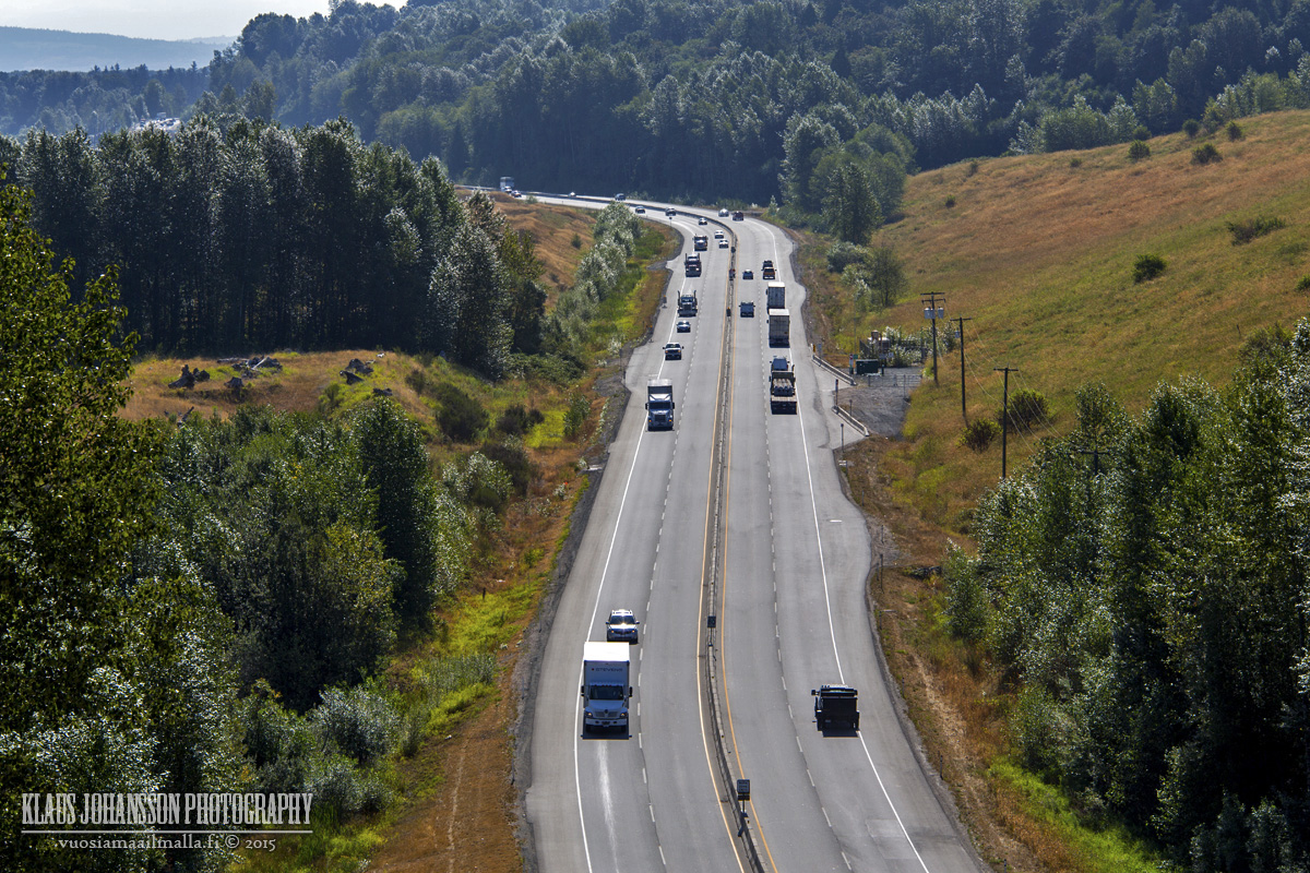
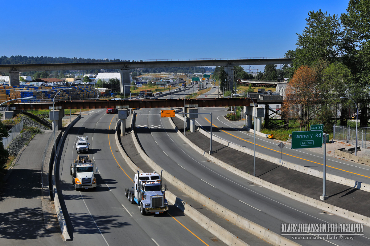
Thursday 10am. You can definitely tell how popular truck route SFPR is being with trucks making half of the traffic!

From Port Mann Bridge.


From Pattullo Bridge.
     
     
  #3529  
Old Posted Oct 2, 2015, 7:03 AM
Mininari Mininari is offline
Registered User
 
Join Date: Jul 2004
Location: Victoria (formerly Port Moody, then Winnipeg)
Posts: 2,446
There really needs to be a climbing lane added to the roadway southbound past 104 avenue where the road climbs the hill to meet Hwy 1.... the climbing lane could act as an auxiliary lane that exits to Hwy 1. Anyone disagree???

The roadway seems to be handling the traffic ok otherwise, but I'm not backing down on my opinions on the Sunbury Interchange.... or lack-of.

Great pictures btw!
     
     
  #3530  
Old Posted Oct 3, 2015, 1:34 AM
BCPhil BCPhil is offline
Registered User
 
Join Date: Jun 2009
Location: Surrey
Posts: 2,578
Quote:
Originally Posted by Mininari View Post
There really needs to be a climbing lane added to the roadway southbound past 104 avenue where the road climbs the hill to meet Hwy 1.... the climbing lane could act as an auxiliary lane that exits to Hwy 1. Anyone disagree???

The roadway seems to be handling the traffic ok otherwise, but I'm not backing down on my opinions on the Sunbury Interchange.... or lack-of.

Great pictures btw!
It definately does. That would actually be my biggest complaint about the whole SFPR (not lack of interchanges). Or maybe second, after the speed limit (haha, I got highbeemed by a truck that was passing me while I'm doing 90+).
     
     
  #3531  
Old Posted Oct 10, 2015, 10:23 AM
deasine deasine is offline
Vancouver Moderator
 
Join Date: Mar 2007
Posts: 5,747
Quote:
South Fraser Perimeter Road to be refinanced

South Fraser Perimeter Road to be refinanced
The South Fraser Perimeter Road in Vancouver, British Columbia is to be refinanced.

ACS Infrastructure Canada (50%), Ledcor (25%) and Star America (25%) own the asset.

The refinancing consists of a 18.25-year, single tranche, CAD 229m (USD 176m) senior secured bond which matures in December 2033. The bond will mature six months prior to the expiration of the contract agreement in June 2034.

The bonds will be a private placement bond offered in both Canada and in the US, according to the Moody’s report released on 5 October.

The bonds are expected to price late next week with financial close to be reached as is customary a source confirmed. SMBC, National Bank Financial and Casgrain are the bond underwrites, the source added.

Moody’s has assigned a provisional A3 rating to the Fraser Transportation Group Partnership (FTG).

The proceeds of the issuance will be used to pay CAD 162m of bank debt and CAD 31m swap breakage.

An equity distribution of CAD 19.9m will also occur. There will be no original sponsor equity remaining in the project following distributions made in year one and year two of the operating phase, as a result.

The Moody’s report notes that the refinancing will provide significant savings to the authority. The report adds that FTG is required to share 50% of the refinancing gain with the province.

The gain will reduce British Columbia’s availability payment by CAD 0.90m per year. The province is expected to save an estimated CAD 16.5m over the remaining term.
(Inframation Group , 2015)
     
     
  #3532  
Old Posted Oct 11, 2015, 5:12 PM
logicbomb logicbomb is offline
Joshua B.
 
Join Date: Sep 2010
Posts: 1,188
From Oct 6th, 2015

http://www.surreyleader.com/opinion/letters/330933751.html

Quote:
Here comes the dangerous part of this poor planning. When you are turning right from the 91 Connector to Highway 17 towards Hope, the slope of the road is contrary to accommodate the pull of the centrifugal force, thus causing the vehicle to tip over, especially big trucks. Adding insult to injury is that this right turn is particularly sharp. An almost identical hazard is present if big rigs are making a left turn from 91 Connector to Highway 17 towards Tsawwassen.
Exactly my sentiments as well. I have witnessed a rollover on that right-turn before too. Furthermore, you have the usual occurrences of two trucks side-by-side blocking the general flow of traffic. There was rather bad congestion on Thursday, and I would say we are only a few years away from needing an extra lane in each direction. Piss poor planning.
     
     
  #3533  
Old Posted Oct 13, 2015, 9:57 PM
officedweller officedweller is offline
Registered User
 
Join Date: Jul 2001
Location: Vancouver
Posts: 41,487
That's the difference between someone being dogmatic and being pragmatic.

The dogmatic planner would say - the road will be signed and designed for a slow speed, so that's the standard I'll design it to - drivers shouldn't be speeding.

The pragmatic planner would say - even though the road is signed for slow speed, drivers may speed, so for safety, we should account for that possibility and accommodate a canter that allows a faster speed.
     
     
  #3534  
Old Posted Oct 14, 2015, 9:01 PM
vango vango is offline
Registered User
 
Join Date: Sep 2008
Posts: 77
New signage for Highway 17:
http://www.vancouversun.com/news/metro/r...nage+changes+highway/11435695/story.html

Quote:
The B.C. Ministry of Transportation has agreed to a slew of changes after public complaints about poor signage on roads in Metro Vancouver and promises more to come for Highway 17, the new South Fraser Perimeter Road.

The province is taking the action after a Vancouver Sun story published in June about confusing signs on Highway 17 sparked a fire storm of comments from motorists who were urged to write in about their biggest beefs.

“We totally appreciate your feedback and have acted on quite a few of them,” confirmed Lina Halwani, the ministry’s South Coast regional manager of engineering, based in Coquitlam. “We’re not saying our system is perfect. Of course, there is room for improvement.”

Ministry engineers draw upon standards set by the Transportation Association of Canada, a provincial manual of standard traffic signs, and comments such as from municipalities.

Ed Miska, the ministry’s director of highway design and engineering, said in Victoria that signage is a balancing act between providing too much and too little information.

“If we put too many signs up there or too much information, the sign can become a distraction or if it takes too long to read then people can slow down to the point it becomes unsafe.”

Sun readers didn’t mince their words about roads signs, calling them ludicrous, a gong show, stupid, and mentally challenged.

“One could be forgiven for thinking that those in charge live in some other country, never travel the routes or don’t drive,” wrote Gary Catherwood of Coquitlam.

Elizabeth McVicar of Surrey added: “I have long been of the opinion that highway signs are for the benefit of those who already know where they’re going.”

Highway 17, which opened in 2013, proved to be the biggest bone of contention with readers. The $1.3-billion freeway links South Delta to the Highway 1 freeway at 176th Street, with three major bridge connections along the way.

Ralph Jones of Chilliwack has endless problems navigating the Highway 17 and Highway 91 interchange, suggesting a “quirky person, or somebody with a malicious sense of humour” is to blame.

The Sun’s senior web editor, Jeff Beamish, recalls the driver of a TransLink route 351 bus who became confused by the road signs as he drove along Highway 99 from South Surrey to the Bridgeport Canada Line station in Richmond.

“Somehow he missed the bus lane and wound up taking his confused commuters south on Highway 17 to Tsawwassen, where he turned around in a parking lot on 56th Street,” Beamish recalls. The meandering trip took more than double the bus route’s usual 35 minutes.

Halwani said that signs initially on Highway 17 were designed to allow residents to find their way through their communities. The Sun’s story showed that drivers from outside the area find the highway very confusing.

The ministry has already posted big signs indicating the Alex Fraser Bridge and plans to install new signs for New Westminster, North Delta, Richmond and Vancouver to clarify motorists’ choices — and says motorists should expect more changes in future.

“Highway 17 is quite unique, a brand new highway in the Lower Mainland,” Halwani said. “We’re looking at the whole corridor and a lot of these signs are going to be upgraded.”

After The Sun’s correspondence, TransLink will also put up a sign for motorists westbound on Golden Ears Way in north Surrey to turn right to access Highway 17. And the City of Surrey has ordered signs alerting drivers southbound off the Pattullo Bridge to turn right onto Scott Road to connect with the new Highway 17.

The biggest complaints outside Metro Vancouver involved the McTavish Interchange near Victoria International Airport in North Saanich. Retired Alberta judge Ben Casson, now a local resident, calls it the “Gary Go Round” in honour of its “chief sponsor,” former Conservative MP Gary Lunn.

Adds Wayne McCrory of Hills in the West Kootenay: “I staying in Sidney recently and my longtime friend told me not to use the new cloverleaf ... south of the ferry terminal. He was so disgusted with the confusing maze and poor signage. I tried it anyways and indeed it is a confusing mess. As diligent as I was, I still ended up in the bus stop turn around. Too little notice, too poor directions.”

The province says in response that signs for the roundabouts at McTavish Interchange have been modified, including directions on the pavement and clearer overhead signs.

“To be honest, we’re not getting as many complaints,” Halwani said.

The City of Vancouver did not respond to a reader’s complaint that the signage is poor and inconsistent for motorists entering the city from the Lions Gate Bridge and trying find their way to the Tsawwassen ferry terminal or Vancouver International Airport.

The province did not agree with all The Sun readers’ suggestions. It tossed cold water on what seemed like a great idea: put up a sign for Whistler-bound American tourists at the Douglas border crossing directing them to turn east on Eighth Avenue then north on 176 Street all the way to Highway 1 — a route that avoids the hassle of driving through downtown Vancouver, especially during rush hour.

The ministry countered that signs typically guide traffic to the next largest destination point — in this case, Vancouver, which is also a toll-free route. A later sign does indicate the route to Highway 1, which would connect with Whistler.

Elsewhere, there is a sign on Highway 17 southwest of Pattullo Bridge that states Delta is 19 kilometres off. In fact, the border to Delta is closer to three kilometres away. The ministry says that any city distance sign provides the distance to the city centre or city hall. Who knew?

The ministry also didn’t sympathize with the motorist who complained that driving westbound on the Upper Levels Highway from North Vancouver or the Second Narrows Bridge there is no sign directing traffic to Lions Gate Bridge via the faster route, Capilano Road. The ministry says that Capilano is a municipal road and that additional signs will be post to direct motorists to the provincial route, Taylor Way.

Here’s a small selection of other complaints from both the The Sun and its readers followed by ministry responses:

DELTA

• Complaint: Driving north from South Delta on Highway 17, there is an exit sign that reads “Vancouver — USA border.” It’s technically accurate, since the lane splits a short distance further, but also confusing, since the two destinations are located in opposite directions along Highway 99.

Response: The ministry will add other destinations including Richmond and Surrey to the exit sign to better indicate that multiple locations can be accessed from this exit.

• Complaint: Have you tried accessing the City of Vancouver landfill in Delta via Highway 17? Good luck with that.

Response: The ministry will place additional signs to the Vancouver landfill corresponding with the City of Vancouver’s preferred routes.

• Complaint: The sign at exit 20 on Highway 99 southbound should mention Highway 10 not Ladner Trunk Road and should mention Langley City.

Response: The ministry will add Surrey and Langley to signs at the next interchange directing motorists to Highway 10 via Highway 91.

• Complaint: Why are there no signs on Highway 17 directing motorists to a gas station?

Response: The ministry is working with local businesses to install signs in the Nordel area to advertise services, such as food, gas and lodging.

SURREY

• Complaint: If one is headed eastbound on Highway 17 and wishes to go to Surrey or Langley, where does one turn off?

Response: Additional signs will be installed to indicate alternative routes to Surrey via Highway 99 south and Highway 17 east. Also, additional signing to Surrey and Langley via Highway 10 will be provided from Highway 99 southbound.

RICHMOND

• Complaint: There are no signs directing drivers from Vancouver International Airport to Burnaby, New Westminster, or even to Highway 91.

Response: From YVR in Richmond, the ministry will add signing to adjacent municipalities including New Westminster, Vancouver, Surrey and Delta, as well as Highway 91.

• Complaint: The lights are too dim in the Massey Tunnel linking Richmond and Delta.

Response: The ministry will adjust and monitor the lighting intensity to improve the brightness.

ABBOTSFORD

• Complaint: Headed eastbound on Fraser Highway at Mount Lehman Road in Abbotsford, a sign shows a sharp curve to the right to get onto the Highway 1 freeway whereas it should be straight ahead and keep right.

Response: The ministry acknowledges that this sign may be confusing for motorists and will be removing it.

To learn more, visit www.vancouversun.com.

[email protected]
     
     
  #3535  
Old Posted Oct 15, 2015, 1:06 AM
Metro-One's Avatar
Metro-One Metro-One is online now
Registered User
 
Join Date: Sep 2008
Location: Japan
Posts: 17,902
Quote:
Originally Posted by logicbomb View Post
From Oct 6th, 2015

http://www.surreyleader.com/opinion/letters/330933751.html


Exactly my sentiments as well. I have witnessed a rollover on that right-turn before too. Furthermore, you have the usual occurrences of two trucks side-by-side blocking the general flow of traffic. There was rather bad congestion on Thursday, and I would say we are only a few years away from needing an extra lane in each direction. Piss poor planning.
As many know here I support major roads in urban areas, but I do not support this style of thinking.

Not every highway needs to be 6 / 8 / 10 lanes.

In metro Van only the #1 and the 99 need to be wider than 4 lanes (excluding bridge decks which should be 6 lanes in most cases due to local add / drop traffic).

The SFPR is fine at 4 lanes, the problem is that it should have been built as free flow from the start. No traffic lights, all interchanges.

4 lane highways work fine throughout most urban areas in Japan. The widest extended span of a freeway I have ever seen here is 8 lanes (in cities far larger than Toronto). Of course these highways are complete free flow (all interchanges), but they are also tolled.

IMO the SFPR should have opened as a tolled freeway (maybe free for commercial and transport vehicles, but tolls for everyone else) with only interchanges for its entire length.

I would support all freeways in Metro-Van being tolled (but done so with upgrades, such as replacing the 91/72nd traffic light with an interchange, replacing the GMT and upgrading the 99, making the GEW full freeway from the SFPR to Lougheed (this would only require two intersections upgraded to interchanges), etc..)

My ultimate fantasy with the scenerio above would be a 4 laned tolled highway built along / under / above Knight Street to a new 6 lane bridge accross the Burrard Inlet (with a now closed Lions Gate to general Traffic). Seeing how this would be the most urban route of highway in the city, a design speed no higher than 70km would be used to allow it to be built around the urban fabric better, instead of demolishing too much existing structures.

I think that would complete Vancouvers road system well, without overbuilding and allowing heavy / through traffic freeflow routes off regular streets without encouraging congestion.

__________________
Bridging the Gap
Check out my Flickr: https://www.flickr.com/photos/30634635@N03/with/29495547810/ and Youtube channel https://www.youtube.com/channel/UCV0_0h9qKlhxXFxuAey_q6Q
     
     
  #3536  
Old Posted Oct 15, 2015, 1:56 AM
Sheba Sheba is offline
Registered User
 
Join Date: Jan 2015
Location: BC
Posts: 4,584
Quote:
Originally Posted by Metro-One View Post
My ultimate fantasy with the scenerio above would be a 4 laned tolled highway built along / under / above Knight Street to a new 6 lane bridge accross the Burrard Inlet (with a now closed Lions Gate to general Traffic). Seeing how this would be the most urban route of highway in the city, a design speed no higher than 70km would be used to allow it to be built around the urban fabric better, instead of demolishing too much existing structures.

I think that would complete Vancouvers road system well, without overbuilding and allowing heavy / through traffic freeflow routes off regular streets without encouraging congestion.

An aboveground highway would equal a viaduct - and we know how Vancouver city council feels about those...
     
     
  #3537  
Old Posted Oct 15, 2015, 5:13 AM
The_Henry_Man The_Henry_Man is offline
HA
 
Join Date: Mar 2006
Location: St. Cloud, MN/Richmond, BC
Posts: 873
Quote:
Originally Posted by Metro-One View Post
As many know here I support major roads in urban areas, but I do not support this style of thinking.

Not every highway needs to be 6 / 8 / 10 lanes.

In metro Van only the #1 and the 99 need to be wider than 4 lanes (excluding bridge decks which should be 6 lanes in most cases due to local add / drop traffic).

The SFPR is fine at 4 lanes, the problem is that it should have been built as free flow from the start. No traffic lights, all interchanges.

4 lane highways work fine throughout most urban areas in Japan. The widest extended span of a freeway I have ever seen here is 8 lanes (in cities far larger than Toronto). Of course these highways are complete free flow (all interchanges), but they are also tolled.

IMO the SFPR should have opened as a tolled freeway (maybe free for commercial and transport vehicles, but tolls for everyone else) with only interchanges for its entire length.

I would support all freeways in Metro-Van being tolled (but done so with upgrades, such as replacing the 91/72nd traffic light with an interchange, replacing the GMT and upgrading the 99, making the GEW full freeway from the SFPR to Lougheed (this would only require two intersections upgraded to interchanges), etc..)

My ultimate fantasy with the scenerio above would be a 4 laned tolled highway built along / under / above Knight Street to a new 6 lane bridge accross the Burrard Inlet (with a now closed Lions Gate to general Traffic). Seeing how this would be the most urban route of highway in the city, a design speed no higher than 70km would be used to allow it to be built around the urban fabric better, instead of demolishing too much existing structures.

I think that would complete Vancouvers road system well, without overbuilding and allowing heavy / through traffic freeflow routes off regular streets without encouraging congestion.
Hwy 91 would most probably be widened to 6 lanes (8 lanes in a few sections in Richmond) first way before Hwy 17 would ever be widened. In fact, of all the driving I've done so far on the 17 ever since it was opened, the only significant traffic jams I've experienced is the infamous 17/91 connector intersection, which should've been an interchange in the first place. Other than that, with conversion to properly designed interchanges along its entire length, the 17 is good enough with 4 lanes in the foreseeable future, especially when it's not really connecting from city centre to another.

Hwy 91, on the other hand, needs to be at least 6 lanes throughout its entire length ASAP.
     
     
  #3538  
Old Posted Oct 15, 2015, 5:49 PM
makr3trkr makr3trkr is offline
Registered User
 
Join Date: Jun 2012
Posts: 593
Quote:
Originally Posted by The_Henry_Man View Post
Hwy 91 would most probably be widened to 6 lanes (8 lanes in a few sections in Richmond) first way before Hwy 17 would ever be widened. In fact, of all the driving I've done so far on the 17 ever since it was opened, the only significant traffic jams I've experienced is the infamous 17/91 connector intersection, which should've been an interchange in the first place. Other than that, with conversion to properly designed interchanges along its entire length, the 17 is good enough with 4 lanes in the foreseeable future, especially when it's not really connecting from city centre to another.

Hwy 91, on the other hand, needs to be at least 6 lanes throughout its entire length ASAP.
Nelson Road's onramp in particular has atrocious congestion almost entirely because large trucks are merging onto the highway at the bend, causing daily backups.

Additionally, Knight Street and 6 road are frequently congested at their exit because of people cutting over at the last second.

There should be an add/drop lane between Nelson and 6 Road/Knight.
     
     
  #3539  
Old Posted Oct 15, 2015, 6:29 PM
Zassk Zassk is offline
Registered User
 
Join Date: Sep 2009
Posts: 2,303
Quote:
Originally Posted by makr3trkr View Post
Nelson Road's onramp in particular has atrocious congestion almost entirely because large trucks are merging onto the highway at the bend, causing daily backups.

Additionally, Knight Street and 6 road are frequently congested at their exit because of people cutting over at the last second.

There should be an add/drop lane between Nelson and 6 Road/Knight.
Absolutely, and all of the necessary overpass clearance is already there, because they were forward-thinking when they built 91.
     
     
  #3540  
Old Posted Oct 16, 2015, 3:06 AM
David's Avatar
David David is offline
David
 
Join Date: Dec 2001
Location: Vancouver Island, British Columbia
Posts: 1,453
Regarding signage, I've always been bothered by the fact that the new westbound Hwy 1 direction signs through Burnaby and Vancouver have Whistler as a control city for Hwy 1. I know that one can eventually get to Whistler this way, but it should indicate Horseshoe Bay as the control city for Hwy 1, and refer to Hwy 99 for continuing on to Whistler
     
     
This discussion thread continues

Use the page links to the lower-right to go to the next page for additional posts
 
 
Closed Thread

Go Back   SkyscraperPage Forum > Regional Sections > Canada > Alberta & British Columbia > Vancouver > Transportation & Infrastructure
Forum Jump


Forum Jump


All times are GMT. The time now is 4:26 AM.

     
SkyscraperPage.com - Privacy Statement - Top

Powered by vBulletin® Version 3.8.7
Copyright ©2000 - 2026, vBulletin Solutions, Inc.