HomeDiagramsDatabaseMapsForum About
     

Go Back   SkyscraperPage Forum > Discussion Forums > City Discussions


Reply

 
Thread Tools Display Modes
     
     
  #1061  
Old Posted Jul 9, 2026, 7:08 PM
Docere Docere is offline
Registered User
 
Join Date: Jul 2014
Posts: 8,834
But didn't these regions grow quite fast? But obviously it's not due to thriving cores but suburban sprawl.

In terms of regional growth, Buffalo is pretty much the same as in 1950, Chicago and Detroit have grown modestly, while Columbus, Indianapolis and KC grew faster.
Reply With Quote
     
     
  #1062  
Old Posted Jul 9, 2026, 7:11 PM
Docere Docere is offline
Registered User
 
Join Date: Jul 2014
Posts: 8,834
Anyone know these cities well enough to post demographic info (income, race/ethnicity, educational attainment) for pre-annexations Columbus, Indianapolis and KC?
Reply With Quote
     
     
  #1063  
Old Posted Jul 9, 2026, 7:21 PM
Wigs's Avatar
Wigs Wigs is offline
Great White North
 
Join Date: Nov 2003
Location: Niagara Region
Posts: 16,214
Quote:
Originally Posted by Docere View Post
But didn't these regions grow quite fast? But obviously it's not due to thriving cores but suburban sprawl.

In terms of regional growth, Buffalo is pretty much the same as in 1950, Chicago and Detroit have grown modestly, while Columbus, Indianapolis and KC grew faster.
Buffalo is the core city, county seat of Erie County which peaked in 1970 at over 1.1 million. Niagara County (Niagara Falls) peaked in or around 1960/1960s at just under 250k

The KC Metro/MSA is around 1 million larger than it was around 1960.
Reply With Quote
     
     
  #1064  
Old Posted Jul 9, 2026, 7:32 PM
3rd&Brown 3rd&Brown is offline
Registered User
 
Join Date: Oct 2007
Posts: 3,032
Quote:
Originally Posted by Crawford View Post
IMO Downtown Columbus is terrible, one of the worst pound-for-pound in the Midwest. Definitely worse than Indy. But everything surrounding downtown is far, far more vibrant and cohesive than Indy, and Columbus just feels more urban and lived-in, with tons of infill. Also feels more progressive, educated and affluent.

I hate to bring up a mall, but Easton Town Center essentially serves as a CBD, and is walkable, lively and quasi-urban. I'd rather stay at Easton than downtown, and I'm an urbanist. At Easton I've walked to a nice dinner and bookstore. Can't do that downtown.
I stay in Short North when I'm in Columbus and I think it's great. I've also stayed downtown one or two times but on the north end so it's walkable ish. At the end of the day, I'd rather be a short uber ride away to a walkable zone than out at Easton Town Center. It's splitting hairs, but even though Short North is technically separated from downtown by an interstate, it doesn't feel like that big of a deadzone as from what I remember, as I think the city streets traverse OVER the interstate as opposed to under it. In my mind, that makes a big difference when thinking about walkability, mentally.
Reply With Quote
     
     
  #1065  
Old Posted Jul 9, 2026, 10:03 PM
Steely Dan's Avatar
Steely Dan Steely Dan is online now
devout Pizzatarian
 
Join Date: Jul 2001
Location: Lincoln Square, Chicago
Posts: 30,312
Quote:
Originally Posted by Docere View Post
Anyone know these cities well enough to post demographic info (income, race/ethnicity, educational attainment) for pre-annexations Columbus, Indianapolis and KC?
The only one that might be easy-ish for is Center Township Indy, because it still exists today as a known thing.

Old city Milwaukee, KC, and Columbus all involve overlaying 1950 city limits maps on current CT maps and adding up tracts the old fashioned way.


I did exactly that to get old city Milwaukee's 2020 population figure.

Super fucking tedious. I don't recommend.
__________________
"Missing middle" housing can be a marvelous middle ground for many middle class families.
Reply With Quote
     
     
  #1066  
Old Posted Jul 9, 2026, 10:39 PM
jmecklenborg jmecklenborg is offline
Registered User
 
Join Date: Jul 2003
Posts: 4,210
Quote:
Originally Posted by Wigs View Post
Have you followed KC at all?
Columbus planned a streetcar line on High St. circa 2005-07, when Coleman was mayor. This was when Short North was turning around but there were still some development gaps between it and OSU. Obviously, High St. boomed without the streetcar line and it's tough to envision such a system working well because the street is relatively narrow and has become quite congested. Also, a big problem with Columbus's street grid is that it does not meet equally at High St., meaning there are many more intersections than there would be otherwise, which really would have complicated streetcar operations.

Here is a typical area where there would have been a lot of turning conflicts:
https://www.google.com/maps/place/Columb..._ep=EgoyMDI2MDcwNy4wIKXMDSoASAFQAw%3D%3D


Meanwhile, KC's Main St. is very wide south of Union Station. There was plenty of space for them to create a fenced-off landscaped median for streetcars in the middle of the road (or consistently protected and landscaped streetcar lanes along the curbs) but for whatever reason they did not do that and although ridership is very high I believe that they could have done a much better job.
Reply With Quote
     
     
  #1067  
Old Posted Jul 9, 2026, 10:43 PM
Docere Docere is offline
Registered User
 
Join Date: Jul 2014
Posts: 8,834
Quote:
Originally Posted by Steely Dan View Post
The only one that might be easy-ish for is Center Township Indy, because it still exists today as a known thing.

Old city Milwaukee, KC, and Columbus all involve overlaying 1950 city limits maps on current CT maps and adding up tracts the old fashioned way.


I did exactly that to get old city Milwaukee's 2020 population figure.

Super fucking tedious. I don't recommend.
So there's 4 hours of your life that you won't get back...
Reply With Quote
     
     
  #1068  
Old Posted Jul 9, 2026, 11:34 PM
ColDayMan's Avatar
ColDayMan ColDayMan is offline
B!tchslapping Since 1998
 
Join Date: Jul 2001
Location: Columbus
Posts: 20,491
Quote:
Originally Posted by Docere View Post
Anyone know these cities well enough to post demographic info (income, race/ethnicity, educational attainment) for pre-annexations Columbus, Indianapolis and KC?
For Columbus, the Old City population is as follows:

1930: 290,564
1940: 306,086
1950: 375,710
1960: 389,222
1970: 348,808
1980: 287,089
1990: 268,265
2000: 246,712
2010: 234,582
2020: 256,939

If you want to look up demographic data for these core tracts, I do have tract maps going back to 1930 here: https://allcolumbusdata.com/demographic-census-tract-maps/ that, I apologize, I don't have time to add up.

This site also may provide assistance for all those cities you'd like info on: https://www.nhgis.org/
__________________
Click the x: _ _ X _ _!
Reply With Quote
     
     
  #1069  
Old Posted Jul 10, 2026, 3:20 AM
craigs's Avatar
craigs craigs is offline
Registered User
 
Join Date: May 2019
Location: Los Angeles
Posts: 10,803
As I understand it from three generations of my family, the inner-city post-WWII population decline was due to wholesale 'urban renewal.' Innermost residential areas that would have still existed in 1950 were subsequently bulldozed and replaced with college campuses and medical facilities, freeways and interchanges, commercial/industrial buildings, and 'capital city' stuff (government buildings, museums, plazas, etc.). For example, almost all residential areas immediately west of the heart of the city disappeared.

Compare this post-WWII aerial with a current Google Maps aerial, with a focus on the periphery of the CBD:

__________________
Chaos upon my enemies, chaos upon my enemies, chaos upon my enemies.
Reply With Quote
     
     
  #1070  
Old Posted Jul 10, 2026, 9:01 PM
ColDayMan's Avatar
ColDayMan ColDayMan is offline
B!tchslapping Since 1998
 
Join Date: Jul 2001
Location: Columbus
Posts: 20,491
Because I was curious, I had someone over at UrbanOhio get the numbers for the 40 sq mi Old City of Columbus racial demographics from https://allcolumbusdata.com/demographic-census-tract-maps/:

White Alone
1950: 328,770
1960: 315,463
1970: 262,832
1980: 202,748
1990: 180,723
2000: 151,394
2010: 146,320
2020: 155,301
---
White, Non-Hispanic
1990: 179,308
2000: 149,215
2010: 140,106
2020: 150,850

Black Alone
1950: 46,692
1960: 72,771
1970: 85,068
1980: 79,345
1990: 80,646
2000: 79,985
2010: 68,928
2020: 66,552
---
Black, Non-Hispanic
1990: 80,273
2000: 79,443
2010: 68,231
2020: 65,724

Asian Alone
1970: 903
1980: 1,808
1990: 5,255
2000: 5,715
2010: 6,490
2020: 7,983
---
Asian, Non-Hispanic
1990: 5,047
2000: 5,692
2010: 6,432
2020: 7,927

Other Alone:
1970: 931
1980: 2,478
1990: 2,000
2000: 10,422
2010: 12,844
2020: 28,396
---
Other, Non-Hispanic
1990: 1,190
2000: 7,863
2010: 8,068
2020: 14,979

Hispanic
1980: 1,467
1990: 2,806
2000: 5,313
2010: 9,139
2020: 17,459

None of this is surprising as black folks have been moving into the 1970's-and-on annexed areas of Columbus, particularly the northeast and far eastside, and Latinos have long been on the westside 1970's annexed areas for a while. The only area I can think of Latinos moving to in the old city is Hilltop, which bleeds into the 70's communities of annexed Columbus (Westgate, Lincoln Village, etc). The Whites (and apparently The Others) love the infill.
__________________
Click the x: _ _ X _ _!
Reply With Quote
     
     
  #1071  
Old Posted Jul 10, 2026, 11:57 PM
jmecklenborg jmecklenborg is offline
Registered User
 
Join Date: Jul 2003
Posts: 4,210
Quote:
Originally Posted by craigs View Post
Compare this post-WWII aerial with a current Google Maps aerial, with a focus on the periphery of the CBD:

Unfortunately, I don't think that the diagonal-streets-converging-on-central-circle plan really added up to much for Indianapolis. If anything, it's an anticlimax. Not as though Columbus is much better - two wide streets meet at right angles and the state capitol is kind of lobbed in their SE armpit.

There are a few planned radials plans around the country that worked a lot better - especially Detroit. Washington, DC is also better, although it's difficult to memorize.
Reply With Quote
     
     
  #1072  
Old Posted Jul 11, 2026, 12:41 AM
Docere Docere is offline
Registered User
 
Join Date: Jul 2014
Posts: 8,834
Center Township (core Indianapolis) is 48% NHW, 26% Black, 12% Hispanic. 38% have a bachelor's degree or higher. Per capita income is $40,705.

So fairly middling, not a Cleveland type "donut." Not that different from Indianapolis as a whole really.

https://censusreporter.org/profiles/06000US1809711512-center-township-marion-county-in/
Reply With Quote
     
     
  #1073  
Old Posted Jul 11, 2026, 12:44 AM
Docere Docere is offline
Registered User
 
Join Date: Jul 2014
Posts: 8,834
Quote:
Originally Posted by ColDayMan View Post
Because I was curious, I had someone over at UrbanOhio get the numbers for the 40 sq mi Old City of Columbus racial demographics from https://allcolumbusdata.com/demographic-census-tract-maps/:

White Alone
1950: 328,770
1960: 315,463
1970: 262,832
1980: 202,748
1990: 180,723
2000: 151,394
2010: 146,320
2020: 155,301
---
White, Non-Hispanic
1990: 179,308
2000: 149,215
2010: 140,106
2020: 150,850

Black Alone
1950: 46,692
1960: 72,771
1970: 85,068
1980: 79,345
1990: 80,646
2000: 79,985
2010: 68,928
2020: 66,552
---
Black, Non-Hispanic
1990: 80,273
2000: 79,443
2010: 68,231
2020: 65,724

Asian Alone
1970: 903
1980: 1,808
1990: 5,255
2000: 5,715
2010: 6,490
2020: 7,983
---
Asian, Non-Hispanic
1990: 5,047
2000: 5,692
2010: 6,432
2020: 7,927

Other Alone:
1970: 931
1980: 2,478
1990: 2,000
2000: 10,422
2010: 12,844
2020: 28,396
---
Other, Non-Hispanic
1990: 1,190
2000: 7,863
2010: 8,068
2020: 14,979

Hispanic
1980: 1,467
1990: 2,806
2000: 5,313
2010: 9,139
2020: 17,459

None of this is surprising as black folks have been moving into the 1970's-and-on annexed areas of Columbus, particularly the northeast and far eastside, and Latinos have long been on the westside 1970's annexed areas for a while. The only area I can think of Latinos moving to in the old city is Hilltop, which bleeds into the 70's communities of annexed Columbus (Westgate, Lincoln Village, etc). The Whites (and apparently The Others) love the infill.
So similar Black share to Columbus as a whole, and a bit whiter.


https://censusreporter.org/profiles/16000US3918000-columbus-oh/
Reply With Quote
     
     
  #1074  
Old Posted Jul 13, 2026, 1:28 AM
Wigs's Avatar
Wigs Wigs is offline
Great White North
 
Join Date: Nov 2003
Location: Niagara Region
Posts: 16,214
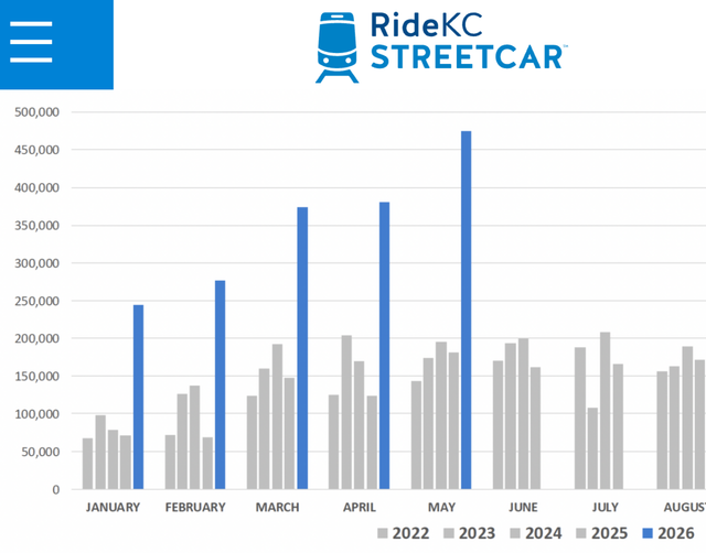
Hosting FIFA World Cup games really helped boost the KC streetcar numbers. And the new riverfront extension (opened in May) and Main St extension (October 2025)helped as well
June ridership numbers came out.
Almost 700,000 riders during June and one day had over 48,000!
For an American streetcar that's one line no less that's amazing.


Source: KC streetcar
https://kcstreetcar.org/ridership/
Reply With Quote
     
     
End
 
 
Reply

Go Back   SkyscraperPage Forum > Discussion Forums > City Discussions
Forum Jump


Forum Jump


All times are GMT. The time now is 2:22 PM.

     
SkyscraperPage.com - Privacy Statement - Top

Powered by vBulletin® Version 3.8.7
Copyright ©2000 - 2026, vBulletin Solutions, Inc.