HomeDiagramsDatabaseMapsForum About
     

Go Back   SkyscraperPage Forum > Regional Sections > Canada > Ontario > Ottawa-Gatineau > Transportation


Reply

 
Thread Tools Display Modes
     
     
  #3361  
Old Posted Apr 14, 2026, 1:46 PM
J.OT13's Avatar
J.OT13 J.OT13 is offline
Moderator
 
Join Date: Mar 2012
Location: Ottawa
Posts: 28,354
Quote:
Originally Posted by Uhuniau View Post
It really would have. But the river view is now reserved for motorists and MUPpers. (MUPpets? Not sure how to self-identify here.)
Video Link


Quote:
Originally Posted by Kitchissippi View Post
The views might have been nice but the grates would have created issues with animals getting in and debris getting blown in. With northern exposure I imagine snow drifting in would also create extra headaches.
That's a good point.

Quote:
Originally Posted by Richard Eade View Post
It might look as if it doesn’t make sense, at first, but you might be thinking in terms of Line 3 being truncated at Lincoln Fields – which it will be, but only a small portion of the time. The usual configuration of Line 1 and 3 is for them to use the central platform only, and alternate.

So, MOST of the time, only the larger, central platform is used. The passenger movements would be as follows:

From Algonquin to Downtown – stay on the inbound Line 1 train;
From Algonquin to Moodie – alight the inbound Line 1 train, cross the platform, and wait for an outbound Line 3 train;
From Moodie to Downtown – stay on the inbound Line 3 train;
From Moodie to Algonquin – alight the inbound Line 3 train, cross the platform, and wait for an outbound Line 1 train;
From Downtown to Algonquin – stay on the outbound Line 1 train;
From Downtown to Moodie – stay on the outbound Line 3 train.

This would be the case for five days a week, excluding late-night service. Only the wide, central platform is in use. The extra side platform is not in use, so there is no reason for ups and downs during these times.

During the other two days, and late at night, Line 3 will only run between Lincoln Fields and Moodie. The Line 3 train will use the single, side platform. Passenger movements will be as follows:

From Algonquin to Downtown – stay on the inbound Line 1 train;
From Algonquin to Moodie – alight on the central platform, up/down to the side platform, and wait for a Line 3 train;
From Moodie to Downtown – alight on the side platform, up/down to the central platform, and wait for a Line 1 train;
From Moodie to Algonquin – alight on the side platform, up/down to the central platform, and wait for a Line 1 train;
From Downtown to Algonquin – stay on the outbound Line 1 train;
From Downtown to Moodie – alight on the central platform, up/down to the side platform, and wait for a Line 3 train.

So, during the minority of time, there will be ups and downs to change platforms. However, because Line 1 and Line 3 trains are at different platforms, it might be possible to time them for a faster transfer

If things were the opposite way, then people would be doing the opposite: ups and downs during the majority of the time, but just crossing the platform on weekends.
That's my interpretation (and Shane's). Best configuration would have been two centre platforms, but because we're running low floors, it was deemed safer to set it up like this to have barriers between tracks.

Quote:
Originally Posted by lrt's friend View Post
9 minute transfer wait times between trains like at South Keys?
Yes, late nights. That is, if we're able and willing to return frequencies to 5 minutes in the central segment off peak.
Reply With Quote
     
     
  #3362  
Old Posted Apr 14, 2026, 2:52 PM
Uhuniau Uhuniau is online now
Registered User
 
Join Date: Jan 2010
Posts: 8,973
MUPpets it is, then!
__________________
___
Enjoy my taxes, Orleans (and Kanata?).
Reply With Quote
     
     
  #3363  
Old Posted Apr 14, 2026, 6:16 PM
Richard Eade Richard Eade is offline
Registered User
 
Join Date: Mar 2008
Location: Nepean
Posts: 2,563
Agreed, that two central platforms may have been able to be created, with the middle track being close enough to both platforms that it could open either the right or left doors, depending on how the trains were running. Such a configuration could have given the following:

During the weekday, daytime:

From Algonquin to Downtown – stay on the inbound Line 1 train;
From Algonquin to Moodie – alight Line 1 at east platform, cross the platform, wait on east platform for Line 3 train;
From Moodie to Downtown – stay on the inbound Line 3 train;
From Moodie to Algonquin – alight Line 3 at east platform, cross the platform, wait on east platform for Line 1 train;
From Downtown to Algonquin – stay on the outbound Line 1 train;
From Downtown to Moodie – stay on the outbound Line 3 train.

And on week-ends and late evenings:

From Algonquin to Downtown – stay on the inbound Line 1 train;
From Algonquin to Moodie – alight Line 1 at east platform, up/down to the west platform, and wait for Line 3 train;
From Moodie to Downtown – alight Line 3 at west platform, up/down to the east platform, and wait for Line 1 train;
From Moodie to Algonquin – alight Line 3 at west platform, cross platform, wait on west platform for Line 1 train;
From Downtown to Algonquin – stay on the outbound Line 1 train;
From Downtown to Moodie – alight Line 1 at west platform, cross platform, wait on west platform for Line 3 train.

So, the benefit would be that Moodie to Algonquin and Downtown to Moodie would be cross-platform maneuvers during week-ends and late evenings. Everything else would remain the same as the current design – which uses an outside platform for Line 3 during low volume times.

It is an improvement for customers, but it pushes the tracks further apart, meaning that the underpass of Carling would have had to be even wider, and more expensive.

That said, here are a few possible options that they may have looked at for the station and track layout:


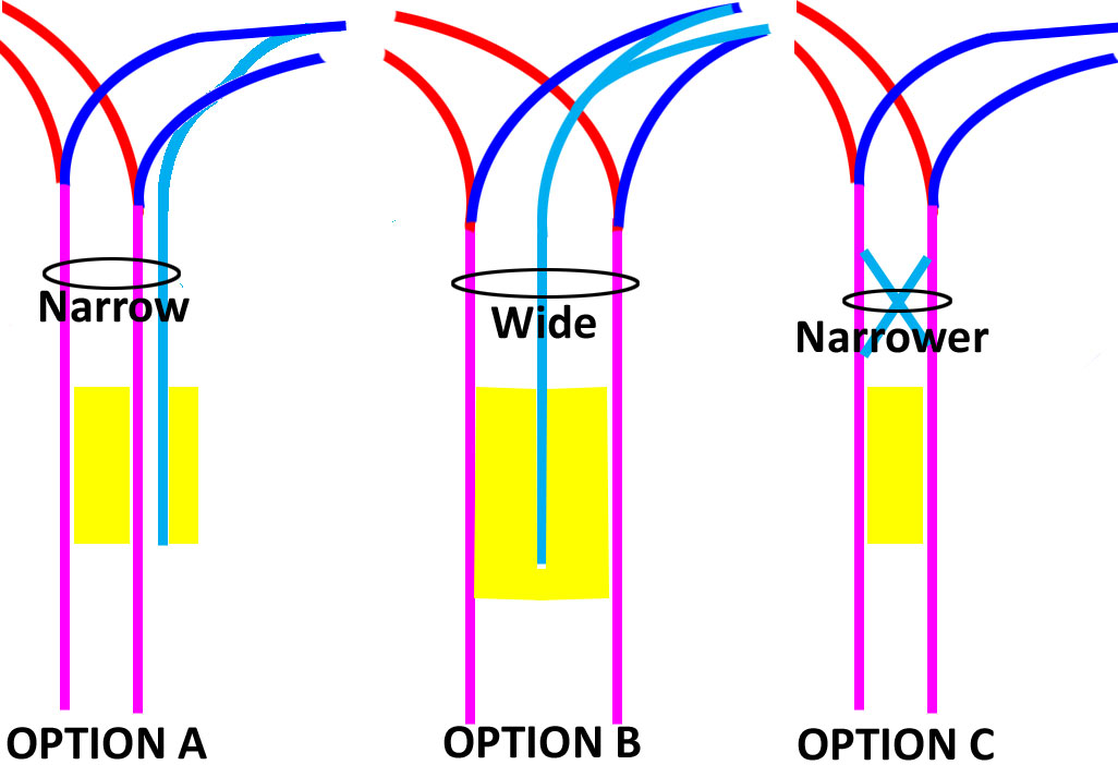
Option A was their choice. However, using the ‘2 Central Platforms’ idea, and realizing that the shortened Line 3 stopped at Lincoln Fields, Option B could have been chosen. In this depiction, the short-turned Line 3 enters a dead-end track so that the 2 central platforms can be joined. This arrangement allows for no need for ‘up and downs’ to move between platforms. Once people descend to the platform level from the bus level, they can go in any direction, at any time. This is the most convenient for changing trains – especially since the truncated Line 3 trains can be loaded in the pocket while Line 1 trains drop passengers. It is likely the most expensive option, however, and so unlikely to be chosen.

Option C is a minimal configuration, but it allows for only cross-platform transfers. In this option, Line 1 and Line 3 trains would need to be timed to arrive separately, but the truncated Line 3 trains could go to either side of the platform to accommodate Line 1 train arrivals. Variable signage would need to accurately display train movements.
Reply With Quote
     
     
  #3364  
Old Posted Apr 14, 2026, 10:29 PM
zzptichka zzptichka is online now
Registered User
 
Join Date: Dec 2015
Location: Outaouias
Posts: 2,345
Option B is the way to go. Just like how they should've done it with the Airport spur making transfer experience much smoother. But they dropped the ball, as usual. I won't be surprised if they never even considered it.
__________________
My aerial Ottawa photos on Flickr 📷
Reply With Quote
     
     
  #3365  
Old Posted Apr 15, 2026, 2:48 AM
lrt's friend lrt's friend is online now
Registered User
 
Join Date: Dec 2006
Posts: 12,724
Quote:
Originally Posted by zzptichka View Post
Option B is the way to go. Just like how they should've done it with the Airport spur making transfer experience much smoother. But they dropped the ball, as usual. I won't be surprised if they never even considered it.
We need value engineering and then the plan fails as was the case at South Keys. Oh well, we dropped the ball and passengers suffer forever with unnecessarily long transfer wait times. We need to make sure that the Line 3 train departs just as passenger exit the Line 1 train. Sorry, that's best we can do.
Reply With Quote
     
     
  #3366  
Old Posted Apr 15, 2026, 1:11 PM
J.OT13's Avatar
J.OT13 J.OT13 is offline
Moderator
 
Join Date: Mar 2012
Location: Ottawa
Posts: 28,354
Quote:
Originally Posted by zzptichka View Post
Option B is the way to go. Just like how they should've done it with the Airport spur making transfer experience much smoother. But they dropped the ball, as usual. I won't be surprised if they never even considered it.
They did consider it at both stations.

For South Keys, I think it was value engineering. The value engineered solution failed to live up to expectations resulting in a longer wait time.

For Lincoln Fields, it was a safety thing. Since we have low floor trains (so low platforms), it makes it easy for an idiot to cross the tracks, so they want barriers between all tracks.
Reply With Quote
     
     
  #3367  
Old Posted Apr 15, 2026, 6:41 PM
OTownandDown OTownandDown is offline
Registered User
 
Join Date: Jul 2018
Posts: 1,606
Here's a lengthy list of cross-platform stations that already exist around the world. As if it would be a hard thing to implement.
https://en.wikipedia.org/wiki/Cross-plat...,from%20the%20upper%2Dlevel%20platforms.

In Ottawa we like to have cyclists and pedestrians get exercise by making them do funky walks and rides, rather than make it easy.

Edit: here's more fun effort copy/pasted from the Wikipedia that could have been expended in order to make this less annoying:

Noncoordinated
In this case, the cross-platform infrastructure offers the possibility of easily changing trains, independently from the waiting time for the second train. In metro systems with short headways, typical waiting time is small, but such a noncoordinated approach could reduce the advantages of stairless cross-platform interchange in railway networks with sparser train traffic.

Coordinated
A more-advanced approach involves the coordination of the lines' timetables to reduce the scheduled changing time, either from one line to the other, or ideally bidirectionally, between both trains simultaneously. Coordinated interchange is widely used in Dutch, German, and Swiss railway networks, where trains of different lines meet at the same platforms in numerous hubs all over the country.

Optimised, with connection guarantee
Most advanced are coordinated cross-platform interchanges wherein interconnected trains also wait for each other, to "guarantee" scheduled interchanges even in the event of modest delays. To limit schedule disruption propagation throughout the entire network, additional waiting time for trains is usually limited to a certain period of time, depending on general network performance, further connections to be guaranteed, train category, train line, and a balanced consideration of other factors.

In practice, most railways coordinating cross-platform interchanges define a certain waiting time window for each guaranteed interchange. Some railway operators will briefly delay train departure signals to allow imminently arriving passengers time to interchange. For example, the Vienna U-Bahn metro signals train drivers to wait briefly, by operating a special white light signal triggered by the approach of an interchange train on another track.
Reply With Quote
     
     
  #3368  
Old Posted Apr 16, 2026, 4:02 AM
Hybrid247 Hybrid247 is offline
Registered User
 
Join Date: Oct 2009
Posts: 1,319
Quote:
Originally Posted by sseguin View Post
Sorry I might not have explained it clearly enough. The single platform will be used for Moodie bound trains in special service, or late night/weekend service. That was previously the plan... whether things will change when it actually opens is another matter. With this setup, outside of the modified service pattern, it will operate as a typical centre platform station.
If the signage in the station is any indication, Moodie-bound trains will be using the side platform full time, even during regular weekday service.
Reply With Quote
     
     
  #3369  
Old Posted Apr 16, 2026, 1:25 PM
lrt's friend lrt's friend is online now
Registered User
 
Join Date: Dec 2006
Posts: 12,724
Quote:
Originally Posted by Hybrid247 View Post
If the signage in the station is any indication, Moodie-bound trains will be using the side platform full time, even during regular weekday service.
Does this mean that Moodie trains will act as a spur ending at Lincoln Fields? Or am I misinterpreting?

If that is true some passengers. coming from Kanata and Stittsville may face three transfers to reach downtown if they don't live near the main bus routes. I hope I am wrong. Local bus within Kanata, main bus to Moodie. train to Lincoln Fields. train to downtown. bus, bus, train. train. Yuck! Operationally efficient, but awful for passengers.
Reply With Quote
     
     
  #3370  
Old Posted Apr 16, 2026, 3:04 PM
AuxTown's Avatar
AuxTown AuxTown is offline
Registered User
 
Join Date: Apr 2006
Location: Ottawa, Canada
Posts: 4,595
Quote:
Originally Posted by lrt's friend View Post
Does this mean that Moodie trains will act as a spur ending at Lincoln Fields? Or am I misinterpreting?

If that is true some passengers. coming from Kanata and Stittsville may face three transfers to reach downtown if they don't live near the main bus routes. I hope I am wrong. Local bus within Kanata, main bus to Moodie. train to Lincoln Fields. train to downtown. bus, bus, train. train. Yuck! Operationally efficient, but awful for passengers.
Oh man, I hope that's not the case. What a nightmare that would be! It's bad enough they didn't extend the train down the ready-to-go ROW along the 417 to Eagleson and Centrum but adding an extra transfer will deter so many Kanata transit riders.
Reply With Quote
     
     
  #3371  
Old Posted Apr 16, 2026, 5:57 PM
skyscraperaccount skyscraperaccount is offline
Registered User
 
Join Date: Jun 2023
Posts: 283
Quote:
Originally Posted by lrt's friend View Post
Does this mean that Moodie trains will act as a spur ending at Lincoln Fields? Or am I misinterpreting?

If that is true some passengers. coming from Kanata and Stittsville may face three transfers to reach downtown if they don't live near the main bus routes. I hope I am wrong. Local bus within Kanata, main bus to Moodie. train to Lincoln Fields. train to downtown. bus, bus, train. train. Yuck! Operationally efficient, but awful for passengers.
AFAIK the park and ride at March will still exist, watch them dump you at the P+R and then you have to take a shuttle between there and Moodie. Line 3 extension can't come soon enough. And then thesupposed plan for March road is ridiculous anyway.

Last edited by skyscraperaccount; Apr 16, 2026 at 6:10 PM.
Reply With Quote
     
     
  #3372  
Old Posted Apr 16, 2026, 8:03 PM
Hybrid247 Hybrid247 is offline
Registered User
 
Join Date: Oct 2009
Posts: 1,319
Quote:
Originally Posted by lrt's friend View Post
Does this mean that Moodie trains will act as a spur ending at Lincoln Fields? Or am I misinterpreting?
No, it just means that westbound Line 3 trains will pull into the side platform of LFS during regular service hours, not the centre platform. The concourse level signs above the stairs that lead to the platforms say the following:

Center platform:
Lines 1 & 3 Trim - East / Line 1 Algonquin - South / Platforms 1 and 2

Side platform:
Line 3 Moodie - West / Platform 3

So the east side of the centre platform will serve Lines 1 and 3 towards downtown, the west side of the center platform will serve Line 1 towards Algonquin, and the side platform will serve Line 3 towards Moodie.
Reply With Quote
     
     
  #3373  
Old Posted Apr 16, 2026, 10:32 PM
lrt's friend lrt's friend is online now
Registered User
 
Join Date: Dec 2006
Posts: 12,724
Quote:
Originally Posted by Hybrid247 View Post
No, it just means that westbound Line 3 trains will pull into the side platform of LFS during regular service hours, not the centre platform. The concourse level signs above the stairs that lead to the platforms say the following:

Center platform:
Lines 1 & 3 Trim - East / Line 1 Algonquin - South / Platforms 1 and 2

Side platform:
Line 3 Moodie - West / Platform 3

So the east side of the centre platform will serve Lines 1 and 3 towards downtown, the west side of the center platform will serve Line 1 towards Algonquin, and the side platform will serve Line 3 towards Moodie.
OK, just to confirm, the side platform is a through rail line so Line 3 comes from downtown and then proceeds to Moodie.
Reply With Quote
     
     
  #3374  
Old Posted Apr 16, 2026, 10:50 PM
Hybrid247 Hybrid247 is offline
Registered User
 
Join Date: Oct 2009
Posts: 1,319
Quote:
Originally Posted by lrt's friend View Post
OK, just to confirm, the side platform is a through rail line so Line 3 comes from downtown and then proceeds to Moodie.
Yes, that seems to be the case based on all the signage I've seen. All stations east of Lincoln Fields have Line 1 & 3 signage, indicating through service. It's of course still possible they will operate Line 3 as a spur line at times, but all signage at least points to through service being the norm.
Reply With Quote
     
     
  #3375  
Old Posted Apr 30, 2026, 12:19 AM
Richard Eade Richard Eade is offline
Registered User
 
Join Date: Mar 2008
Location: Nepean
Posts: 2,563
I happened to pass through Baseline Station today, so I meandered over to look at the new LRT tracks.

This is what happens when the City has no idea what it should be designing for, so it defaults to a busway design:


And to answer your question; it was taken with the 3x zoom on my phone – so not a super long lens. There really are that many curves in a short distance. The curves are VERY obvious and should have been so to anyone laying out the area with an eye on adding trains. The zigging and zagging will require the trains to travel more slowly because of those reversing curves.

All the City had to do was turn the tunnel toward the underpass of Baseline Road. But, NO. The City put it parallel to the southern section of Woodroffe. I suppose the thinking (if I can call it that) was that buses have no problem following serpentine roads. Unfortunately, it seems that no-one thought about the trains – probably because this city had no real experience designing for trains.

Well, now we will get increased noise, maintenance, and slower speed.

And there are two tubes of the tunnel that don’t have track going to them. In the GeoOttawa map, there are lines for future tracks – but, apparently not currently populated. I find this odd, since the tracks that are installed are only half depth, as they are inner tracks that stop at the central platform. The outside tubes would have allowed more train storage.

I also have my doubts as to whether extra tracks can be easily added in the future to access the outer tubes. There appears to be lots of infrastructure in the way. Not the least of which is a wall on the west side.

Reply With Quote
     
     
  #3376  
Old Posted Apr 30, 2026, 3:35 AM
OCCheetos OCCheetos is offline
Registered User
 
Join Date: Aug 2017
Posts: 2,103
Quote:
And to answer your question; it was taken with the 3x zoom on my phone – so not a super long lens. There really are that many curves in a short distance. The curves are VERY obvious and should have been so to anyone laying out the area with an eye on adding trains. The zigging and zagging will require the trains to travel more slowly because of those reversing curves.
A 3x zoom on most phone camera is around a 70mm focal length on a full frame equivalent camera. That's enough to introduce some compression.

This is what the alignment looks like from above. Those curves are very gentle beyond the final curve in and out of the tunnels.


Compare that to the alignment between Lees and uOttawa, for example. It is mostly straight, but has some gentle curves. Trains travel at their tops speeds along this section.


We don't know the track speeds in this new section yet, but the cost of replacing the Baseline overpass, the Pinecrest Creek bridge, and realigning the tunnel(?) are hard to justify to shave.. how much time do you think this would even save? All to readapt the alignment from a decision that predated the LRT?

The change of alignment east of Blair is far more egregious.

Quote:
And there are two tubes of the tunnel that don’t have track going to them. In the GeoOttawa map, there are lines for future tracks – but, apparently not currently populated. I find this odd, since the tracks that are installed are only half depth, as they are inner tracks that stop at the central platform. The outside tubes would have allowed more train storage.

I also have my doubts as to whether extra tracks can be easily added in the future to access the outer tubes. There appears to be lots of infrastructure in the way. Not the least of which is a wall on the west side.
The tracks can store two double-car trains. It's not really clear what the need for more storage is at this point since it's not a yard, and Corkstown is not that far.

Since you know what the future alignment is from looking at GeoOttawa, I'm puzzled why you think it hasn't be protected for? The angling of the wall on the west side very clearly matches the positioning of the future switch shown on GeoOttawa.
Reply With Quote
     
     
  #3377  
Old Posted Apr 30, 2026, 12:31 PM
Richard Eade Richard Eade is offline
Registered User
 
Join Date: Mar 2008
Location: Nepean
Posts: 2,563
My point is that there really wasn’t a need to have most of those curves – if there had been serious thought about a train going through a station at Baseline Station.

For example, here is a straight line from the Queensway underpass through the Baseline underpass:


There were a couple of issues with this straight alignment, however: The Transitway had been built in the center of the corridor to maximize the buffer to homes; and the creek mostly ran on the east side of the area (south of Iris, that is). There were worries of NIMBYism – which is why the Transitway was centered – thus, it was simpler to just keep the Transitway alignment for the tracks.

That said, I have much less of a problem with the sweeping curve and single correction between the 417 and Baseline Road than I do with the orientation of the huge tunnel built next to Algonquin’s ACCE building.

This was all City of Ottawa land. The City provided it to Algonquin for their new building. ANY LAYOUT could have been used – including a tunnel that pointed towards the Baseline underpass. Algonquin was custom-designing their building to fit the land that was being provided – and Algonquin was open to making changes. Indeed, Algonquin first designed their building, based on what the City had designed for its transit system. Then the City changed its mind and Algonquin had to flip their building around at the last minute. The college was very accommodating to the City’s dithering.

Just because the old Baseline Transitway Station was built, in an open field, parallel to Woodroffe, there was no requirement for the tunnel to also be built parallel to Woodroffe. This was just another extremely poor decision based on a fundamental lack of understanding about designing for trains.

As for pre-dating the LRT, OCCheetos, the tunnel was built with the LRT very much in mind. The problem was that just building a tunnel without knowing what you are doing is not a good plan.

I have not suggested that the Baseline underpass nor the tunnel should be re-aligned. The tunnel should have been aligned properly when it was originally built. At this point, I realize that I am crying over spilled milk. We are stuck with what we have.

The Baseline tunnel is such a blatant example of poor planning that I hope that bringing it up (again and again) will spark some of the planners at the City to think more holistically about what they are laying out. (The crazy, extra $50M, deke along Woodroffe, south of the track would be a great place to start.) Oh, and the City should buy a box of STRAIGHT rulers and hand them out to the planners before it does any further ‘designing’ for trains.
Reply With Quote
     
     
  #3378  
Old Posted May 1, 2026, 2:21 PM
J.OT13's Avatar
J.OT13 J.OT13 is offline
Moderator
 
Join Date: Mar 2012
Location: Ottawa
Posts: 28,354
I agree Baseline/Algonquin Station was poorly thought out. I imagine they wanted the station slightly closer to the City offices on Constellation. That's the only reason I could think of.

My biggest issue is the location of the bus loop. For one, it will need to be torn down for Stage 3 since its in the way of extending the tunnel, so if Watson's timelines for Stage 2 and Stage 3 held, that would be a 5 year life tops.

Mostly the loop being south of the station means Baseline BRT buses will have a heluva of a detour to serve the station.
Reply With Quote
     
     
  #3379  
Old Posted May 1, 2026, 3:50 PM
Richard Eade Richard Eade is offline
Registered User
 
Join Date: Mar 2008
Location: Nepean
Posts: 2,563
Yup, that whole area is a mess.

It went from a plan to have the buses run on Navaho (which is why that overpass is so wide, and oddly configured) to moving the buses to the south (to, apparently, free up Ottawa-owned developable land along Woodroffe, between Navaho and Baseline roads for TOD, and keep the P&R). That forced Algonquin to flip its building design (which is why there is such an awkward entrance to the loading area that requires a U-turn on Navaho). But even after such a drastic change, the City didn’t re-evaluate other components.

The tunnel, for instance was designed to have trains in the inside tubes stopping at a central platform – which, it seems, is what is still going to happen. And the outside tubes were to carry buses from the south to a turning loop around the headhouse, north of Navaho. Once it became clear that the buses would be stopping south of College Ave., those outer tubes could have been deleted – reducing the price of the tunnel, and making it more compact.

Alas, because there was so little actual understanding of what the City wanted in the first place, meaning that major decisions were now being made on the fly, it was too late to put the tunnel on a diet. An excuse was created that the extra tubes would be used for train storage. Apparently, that was just spin. They are not even laying tracks for the trains to get to those tubes. (But, of course, it is a future possibility – like the additional station east of Blair, near Gloucester High School.)

Now, look at the bus loop that we are getting at the future Algonquin Station. (Yes, J.OT13, it is so far away from Baseline Road, that they are changing the name to drop the road reference.) The idea for the north loop was a tight loop that dropped people right at the headhouse. The new loop is HUGE. Like Hurdman, and Tunney’s Pasture, it will involve lots of unsheltered walking to bus stops.
Reply With Quote
     
     
  #3380  
Old Posted May 1, 2026, 5:00 PM
Uhuniau Uhuniau is online now
Registered User
 
Join Date: Jan 2010
Posts: 8,973
Quote:
Originally Posted by J.OT13 View Post
Mostly the loop being south of the station means Baseline BRT buses will have a heluva of a detour to serve the station.
At every conceivable juncture in the LRT saga, the designers have shown a consistent inability to think like a passenger.
__________________
___
Enjoy my taxes, Orleans (and Kanata?).
Reply With Quote
     
     
This discussion thread continues

Use the page links to the lower-right to go to the next page for additional posts
 
 
Reply

Go Back   SkyscraperPage Forum > Regional Sections > Canada > Ontario > Ottawa-Gatineau > Transportation
Forum Jump


Forum Jump


All times are GMT. The time now is 9:25 PM.

     
SkyscraperPage.com - Privacy Statement - Top

Powered by vBulletin® Version 3.8.7
Copyright ©2000 - 2026, vBulletin Solutions, Inc.