SkyscraperPage Forum
>
Photography Forums
>
Found City Photos
Old city photos
User Name
Remember Me?
Password
Register
FAQ
Go to Page...
Prev
1
2
Next
Viewing Page
2
of
2
Thread Tools
Display Modes
#
21
Posted
Nov 25, 2008, 5:11 PM
oldmanshirt
Registered User
Join Date: Mar 2008
Location: SATX > KCMO > DFW
Posts: 1,170
Quote:
Originally Posted by
Keep-SA-Lame
http://texashistory.unt.edu/permalink/meta-pth-41356:1
Neat map of San Antonio in 1891 from the Light.
That's funny, downtown looks pretty much the same.
oldmanshirt
View Public Profile
Find all posts by oldmanshirt
#
22
Posted
Nov 27, 2008, 6:55 AM
KevinFromTexas
Meh
Join Date: Jul 2001
Location: Austin <------------> Birmingham?
Posts: 57,327
I-37/I-10 interchange construction in San Antonio in 1966.
http://www.texasfreeway.com/SanAnton...c_photos.shtml
__________________
Conform or be cast out.
KevinFromTexas
View Public Profile
Find all posts by KevinFromTexas
#
23
Posted
Mar 6, 2009, 2:30 AM
rockyi
Bah!
Join Date: Sep 2003
Location: Rock Island, Illinois
Posts: 16,399
Lets bring this thread back to life.
Rock Island pano. Circa 1907:
http://www.linkpendium.com/genealogy...Island/images/
__________________
My feet hurt!
rockyi
View Public Profile
Find all posts by rockyi
#
24
Posted
Mar 8, 2009, 2:13 PM
rockyi
Bah!
Join Date: Sep 2003
Location: Rock Island, Illinois
Posts: 16,399
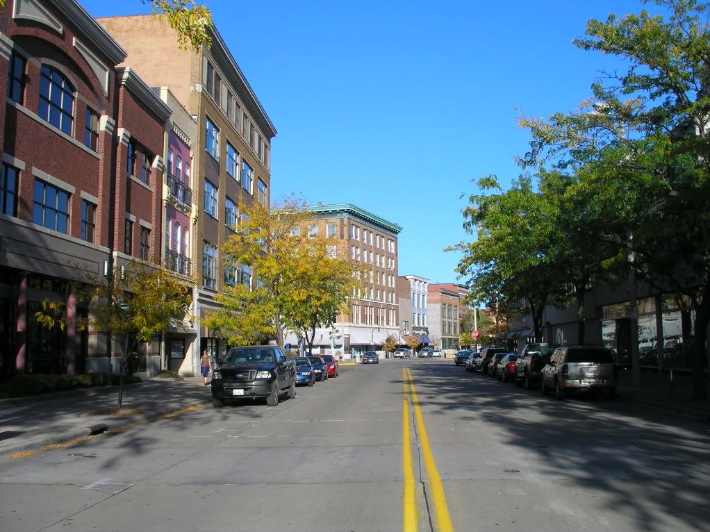
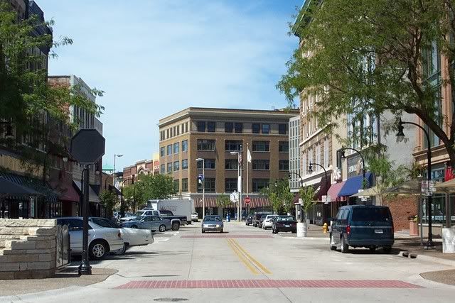
Postcard view of 2nd ave. Rock Island approx. 1912.
http://www.linkpendium.com/genealogy...Island/images/
Same view in 2004. (Things don't change very quickly here
)
__________________
My feet hurt!
Last edited by rockyi; Mar 8, 2009 at
2:39 PM
.
rockyi
View Public Profile
Find all posts by rockyi
End
Prev
1
2
Next
Viewing Page
2
of
2
SkyscraperPage Forum
>
Photography Forums
>
Found City Photos
Old city photos
Forum Jump
User Control Panel
Private Messages
Subscriptions
Who's Online
Search Forums
Forums Home
Global Projects & Construction
City Compilations
Supertall Construction
Skyscraper & Highrise Construction
Proposals
General Development
Discussion Forums
Buildings & Architecture
City Discussions
Transportation
Engineering
Photography Forums
My City Photos
Found City Photos
General Photography
Regional Sections
América Latina
Argentina
Obras & Proyectos Buenos Aires y Capital
Obras & Proyectos Grandes Ciudades del Interior
Infraestructura & Transporte
Resto del Mundo
La Tanguería
Brasil
Fóruns Regionais
Regiões Metropolitanas Mundiais
Regiões Metropolitanas Nacionais
Regiões Metropolitanas Regionais
Cidades do interior & Região
Pequenas Cidades
Fóruns Gerais
Arquitetura & Urbanismo
Projetos - Arquitetura
Projetos - Urbanismo
Infraestrutura & Transporte
Skybar Boteco
Notícias do Brasil - Imprensa Nacional
Fotos
México
Asia-Pacific
Australia
China
Hong Kong
India
Malaysia
Taiwan
Canada
Atlantic Provinces
Halifax
St. John's
Québec
Ville de Québec
Montréal
Montréal Projects & Construction
Ontario
Toronto
Toronto Projects & Construction
Ottawa-Gatineau
Hamilton
London
Manitoba & Saskatchewan
Alberta & British Columbia
Edmonton
Calgary
Vancouver
Europe
Middle East & Africa
United States
Midwest
Chicago Projects & Construction
Mountain West
Northeast
New York Projects & Construction
Philadelphia
Philadelphia Projects & Construction
Pacific West
Portland
Sacramento Area
Los Angeles Projects & Construction
San Francisco Projects & Construction
Seattle Projects & Construction
Southeast
Atlanta
Southwest
Texas & Southcentral
Austin
Houston Projects & Construction
San Antonio
Diagrams & Database
Diagrams
Building Requests & Database Corrections
Completed Requests
Drawing Requests
Drawing Requests Completed
Urban Art
Google Sketchup
Skyscraper & Urban Art
«
Previous Thread
|
Next Thread
»
«
Previous Thread
|
Next Thread
»
Thread Tools
Show Printable Version
Display Modes
Linear Mode
Switch to Hybrid Mode
Switch to Threaded Mode
Forum Jump
User Control Panel
Private Messages
Subscriptions
Who's Online
Search Forums
Forums Home
Global Projects & Construction
City Compilations
Supertall Construction
Skyscraper & Highrise Construction
Proposals
General Development
Discussion Forums
Buildings & Architecture
City Discussions
Transportation
Engineering
Photography Forums
My City Photos
Found City Photos
General Photography
Regional Sections
América Latina
Argentina
Obras & Proyectos Buenos Aires y Capital
Obras & Proyectos Grandes Ciudades del Interior
Infraestructura & Transporte
Resto del Mundo
La Tanguería
Brasil
Fóruns Regionais
Regiões Metropolitanas Mundiais
Regiões Metropolitanas Nacionais
Regiões Metropolitanas Regionais
Cidades do interior & Região
Pequenas Cidades
Fóruns Gerais
Arquitetura & Urbanismo
Projetos - Arquitetura
Projetos - Urbanismo
Infraestrutura & Transporte
Skybar Boteco
Notícias do Brasil - Imprensa Nacional
Fotos
México
Asia-Pacific
Australia
China
Hong Kong
India
Malaysia
Taiwan
Canada
Atlantic Provinces
Halifax
St. John's
Québec
Ville de Québec
Montréal
Montréal Projects & Construction
Ontario
Toronto
Toronto Projects & Construction
Ottawa-Gatineau
Hamilton
London
Manitoba & Saskatchewan
Alberta & British Columbia
Edmonton
Calgary
Vancouver
Europe
Middle East & Africa
United States
Midwest
Chicago Projects & Construction
Mountain West
Northeast
New York Projects & Construction
Philadelphia
Philadelphia Projects & Construction
Pacific West
Portland
Sacramento Area
Los Angeles Projects & Construction
San Francisco Projects & Construction
Seattle Projects & Construction
Southeast
Atlanta
Southwest
Texas & Southcentral
Austin
Houston Projects & Construction
San Antonio
Diagrams & Database
Diagrams
Building Requests & Database Corrections
Completed Requests
Drawing Requests
Drawing Requests Completed
Urban Art
Google Sketchup
Skyscraper & Urban Art
All times are GMT. The time now is
10:42 PM
.
SkyscraperPage.com
-
Archive
-
Privacy Statement
-
Privacy Manager
Top
Powered by vBulletin® Version 3.8.7
Copyright ©2000 - 2024, vBulletin Solutions, Inc.


 Prev
Prev


 )
)

 Linear Mode
