HomeDiagramsDatabaseMapsForum About
     

Go Back   SkyscraperPage Forum > Regional Sections > Canada


Reply

 
Thread Tools Display Modes
     
     
  #21  
Old Posted Dec 18, 2023, 1:39 PM
MolsonExport's Avatar
MolsonExport MolsonExport is offline
The Vomit Bag.
 
Join Date: Oct 2003
Location: Otisburgh
Posts: 44,919
Quote:
Originally Posted by someone123 View Post
These numbers are likely changing extremely rapidly in the Maritimes. Halifax is growing by around 5% per year and 2% of the provincial population got moved into the CMA in the 2021 census period. Charlottetown is just a bit under the 100,000 cutoff and likely has better services than many areas just over 100,000. Most provinces follow a pattern where around half or more of the provincial population is in some core area.

Statistics Canada has finer-grained geographical data on remoteness in Canada: https://www150.statcan.gc.ca/n1/pub/...020002-eng.htm


You could quibble with this map ranking some farming areas well outside of the Southern Ontario metros in a higher category than anywhere in 5 provinces but it's good to try to move to a finer-grained scale than just urban-rural. You could look at economic basis and diversity (resource based vs. services and so on). Some places "look rural" but have an urban economy, and it depends on how people work and travel options.
Northern Manitoba is Very Remote. Who knew?
__________________
The whole problem with the world is that fools and fanatics are always so certain of themselves, and wiser people so full of doubts. (Bertrand Russell)

Last edited by MolsonExport; Dec 18, 2023 at 1:50 PM.
Reply With Quote
     
     
  #22  
Old Posted Dec 18, 2023, 1:53 PM
MonctonRad's Avatar
MonctonRad MonctonRad is online now
Wildcats Rule!!
 
Join Date: Jun 2008
Location: Moncton NB
Posts: 34,626
Quote:
Originally Posted by MolsonExport View Post
Northern Manitoba is Very Remote. Who knew?
Apparently it is more remote than Alert or Resolute!
__________________
Go 'Cats Go
Reply With Quote
     
     
  #23  
Old Posted Dec 18, 2023, 3:04 PM
drew's Avatar
drew drew is offline
the first stamp is free
 
Join Date: Feb 2004
Location: Hippyville, Winnipeg
Posts: 8,017
yeah, areas of Northern Manitoba are very remote, but I don't think you would ever consider them more remote than say...Baffin Island or Ellesmere Island.
Reply With Quote
     
     
  #24  
Old Posted Dec 18, 2023, 4:36 PM
Arrdeeharharharbour Arrdeeharharharbour is offline
Cap the Cut!
 
Join Date: Oct 2021
Location: Halifax
Posts: 685
The inclusion of the north symbol on this map by the creator calls into question their knowledge of map making and/or attention to detail. In terms of direction this map is fibbing to all but those who exist along a single line of longitude.
Reply With Quote
     
     
  #25  
Old Posted Dec 18, 2023, 6:39 PM
TorontoDrew's Avatar
TorontoDrew TorontoDrew is offline
Registered User
 
Join Date: Nov 2014
Posts: 9,791
That map seems a little flawed. Like most of Northern Ontario and the vasy majority of the territories should be very remote.

Here is a map of every single road in Canada it's large but worth it.

source: https://nuvomagazine.com


And her is a map of tree coverage in Canada.

Reply With Quote
     
     
  #26  
Old Posted Dec 18, 2023, 6:50 PM
someone123's Avatar
someone123 someone123 is offline
hähnchenbrüstfiletstüc
 
Join Date: Nov 2001
Location: Vancouver
Posts: 33,694
The road map uses roadway classification data that's very inconsistent between provinces and often doesn't match the scale and importance of the roads. A yellow line can be a minor 2-lane rural road in one area and a 10-lane urban freeway in another.
Reply With Quote
     
     
  #27  
Old Posted Dec 18, 2023, 9:16 PM
Harrison's Avatar
Harrison Harrison is offline
A Better Place
 
Join Date: Jan 2007
Location: Edmonton
Posts: 2,790
Quote:
Originally Posted by someone123 View Post
The road map uses roadway classification data that's very inconsistent between provinces and often doesn't match the scale and importance of the roads. A yellow line can be a minor 2-lane rural road in one area and a 10-lane urban freeway in another.
Doesn't that map just classify all of those yellow lines as Provincnial highways? Would make sense because then the 401 and Highway 1 in the NWT would be the same classification.
__________________
Bingo bango bongo
Reply With Quote
     
     
  #28  
Old Posted Dec 18, 2023, 9:21 PM
manny_santos's Avatar
manny_santos manny_santos is offline
Registered User
 
Join Date: Jul 2006
Location: New Westminster
Posts: 5,012
Quote:
Originally Posted by Harrison View Post
Doesn't that map just classify all of those yellow lines as Provincnial highways? Would make sense because then the 401 and Highway 1 in the NWT would be the same classification.
In Ontario, looks like the yellow lines also include County/Regional roads.
Reply With Quote
     
     
  #29  
Old Posted Dec 18, 2023, 9:25 PM
manny_santos's Avatar
manny_santos manny_santos is offline
Registered User
 
Join Date: Jul 2006
Location: New Westminster
Posts: 5,012
Quote:
Originally Posted by niwell View Post
I get the distinction but in Ottawa's case it doesn't really make sense to exclude Kanata when Orleans and Barrhaven are included. It's an artificial boundary between the two and Kanata is very much part of what's considered Ottawa.
They also have White Rock classified separately from Vancouver, and the map even shows the Population Centre to include South Surrey. While White Rock is a separate municipality, it does have a rural gap between the rest of Metro Vancouver. Aldergrove, Aldergrove East, Ladner and Tsawwassen are also separate Population Centres. (I don't know what the point of Aldergrove East is, it's connected to Aldergrove and I've never heard anyone refer to "Aldergrove East".)

Surrey, as a municipality is unique in that it falls in two different Population Centres and has a section not part of a Population Centre - part in White Rock, part in Vancouver, and part in neither. And Delta falls in three.
Reply With Quote
     
     
  #30  
Old Posted Dec 18, 2023, 9:30 PM
someone123's Avatar
someone123 someone123 is offline
hähnchenbrüstfiletstüc
 
Join Date: Nov 2001
Location: Vancouver
Posts: 33,694
Quote:
Originally Posted by manny_santos View Post
In Ontario, looks like the yellow lines also include County/Regional roads.
The designations are sort of internally consistent per province but like I said don't correspond to the development level.

One funny example is that NS-106, a 2-lane road, is designated in the highest category because it was deemed a part of the TCH as it runs to the PEI ferry. That hasn't been the main route to PEI since the bridge was built.

NS-102 is basically the main artery in NS which connects most of the population to the mainland but it's not designated as part of the TCH. It gets the same designation as non-twinned or controlled-access rural roads in a number of other provinces.
Reply With Quote
     
     
  #31  
Old Posted Dec 18, 2023, 9:31 PM
MolsonExport's Avatar
MolsonExport MolsonExport is offline
The Vomit Bag.
 
Join Date: Oct 2003
Location: Otisburgh
Posts: 44,919
it is still a pretty cool graphic.
__________________
The whole problem with the world is that fools and fanatics are always so certain of themselves, and wiser people so full of doubts. (Bertrand Russell)
Reply With Quote
     
     
  #32  
Old Posted Dec 18, 2023, 9:42 PM
Docere Docere is offline
Registered User
 
Join Date: Jul 2014
Posts: 7,364
Reply With Quote
     
     
  #33  
Old Posted Dec 18, 2023, 11:16 PM
TorontoDrew's Avatar
TorontoDrew TorontoDrew is offline
Registered User
 
Join Date: Nov 2014
Posts: 9,791
According to this site Canada's urbanized population is 81.8%. Just above France with 81.5% and just below Palau at 82%. Canada's uban population rate is growing by 0.95% each year. These stats are from 2022.

https://worldpopulationreview.com/co...ized-countries

urbanization by Andrew Moore, on Flickr


If you don't know like me, Palua is a tiny Island Nation. It looks amazing. Only 18,000 people.

from expedia.ca
Reply With Quote
     
     
  #34  
Old Posted Dec 19, 2023, 2:58 AM
MolsonExport's Avatar
MolsonExport MolsonExport is offline
The Vomit Bag.
 
Join Date: Oct 2003
Location: Otisburgh
Posts: 44,919
^looks gorgeous. Also looks highly vulnerable to climate change.
__________________
The whole problem with the world is that fools and fanatics are always so certain of themselves, and wiser people so full of doubts. (Bertrand Russell)
Reply With Quote
     
     
  #35  
Old Posted Dec 19, 2023, 4:26 AM
Docere Docere is offline
Registered User
 
Join Date: Jul 2014
Posts: 7,364
Using the 500,000 threshold for "large city and adding Oshawa and Milton to Toronto, White Rock to Vancouver, Kanata to Ottawa and St. Jerome to Montreal - 51% of Canadians live in urban areas over 500,000.

Lower than Australia (64%), about the same as the US (53%), higher than the UK (39%).

However Canadians are less likely to live in low-density suburbs than Americans. The typical American suburb is more like Newmarket or Maple Ridge than Mississauga or Surrey.
Reply With Quote
     
     
  #36  
Old Posted Dec 19, 2023, 4:43 AM
Loco101's Avatar
Loco101 Loco101 is offline
Registered User
 
Join Date: May 2013
Location: Timmins, Northern Ontario
Posts: 7,710
Quote:
Originally Posted by Docere View Post

However Canadians are less likely to live in low-density suburbs than Americans. The typical American suburb is more like Newmarket or Maple Ridge than Mississauga or Surrey.
That seems correct from my own observations. It's hard to think of any suburban American cities that have a large number of skyscrapers like you see Mississauga or even Surrey.
Reply With Quote
     
     
  #37  
Old Posted Dec 19, 2023, 6:36 AM
Changing City's Avatar
Changing City Changing City is offline
Registered User
 
Join Date: Nov 2016
Posts: 5,911
Quote:
Originally Posted by Docere View Post
The typical American suburb is more like Newmarket or Maple Ridge than Mississauga or Surrey.
Maple Ridge seems to be ok with having towers. Newmarket on the other hand, maybe not so much?
__________________
Contemporary Vancouver development blog, https://changingcitybook.wordpress.com/ Then and now Vancouver blog https://changingvancouver.wordpress.com/
Reply With Quote
     
     
  #38  
Old Posted Dec 19, 2023, 2:17 PM
niwell's Avatar
niwell niwell is offline
sick transit, gloria
 
Join Date: Nov 2004
Location: Roncesvalles, Toronto
Posts: 11,062
Newmarket definitely has a few midrises / towers under construction or proposed and a decent number of older apartment buildings built at various points in time. Despite the ridiculous characterization of a "monstrous thing" I do actually think that it probably wasn't the best spot for new development. The historic Newmarket downtown is a bit East of Yonge st and the site is one of the more interesting corners in that part of the GTA (and the building is actually being expanded as a hotel): https://maps.app.goo.gl/ykU9hjk7ZsH749vU8

New towers under construction:
https://maps.app.goo.gl/aGxrwAohARxbRbsx9
https://maps.app.goo.gl/P7ZtZiyS98mDEW187

I'm sure the timeline on this is pretty long but there's a big proposal for the Upper Canada Mall to be redeveloped: https://urbantoronto.ca/database/pro...elopment.50474
__________________
Check out my pics of Johannesburg
Reply With Quote
     
     
  #39  
Old Posted Dec 19, 2023, 3:19 PM
thewave46 thewave46 is offline
Registered User
 
Join Date: Aug 2013
Posts: 3,477
Quote:
Originally Posted by someone123 View Post

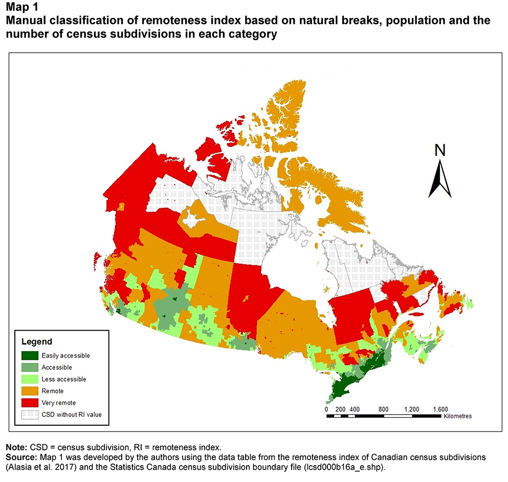
This is such a weird map from a practical point of view. I get it meets some standardized statistical criteria, but still.

Northern Manitoba and much of Northwestern Ontario are about the same 'remoteness', if the only way in or out is a winter road/bush plane. Yet the map classifies them differently.

I'd grade it by presence of all-weather/season highways, number of transportation options (car/bus/train/airport), and proximity to nearest CMA.

Yet, it classifies Baffin Island as about as remote as Kenora, 3 hours by car from Winnipeg. Sure.
Reply With Quote
     
     
  #40  
Old Posted Dec 19, 2023, 3:47 PM
thebasketballgeek's Avatar
thebasketballgeek thebasketballgeek is offline
Registered User
 
Join Date: Nov 2013
Location: Rimouski, Québec
Posts: 1,645
Quote:
Originally Posted by Loco101 View Post
That seems correct from my own observations. It's hard to think of any suburban American cities that have a large number of skyscrapers like you see Mississauga or even Surrey.
Depending on what you would consider a suburb Arlington VA, Jersey City, and Bellevue WA I would say fit that Mississauga/Surrey mold.
Reply With Quote
     
     
This discussion thread continues

Use the page links to the lower-right to go to the next page for additional posts
 
 
Reply

Go Back   SkyscraperPage Forum > Regional Sections > Canada
Forum Jump


Forum Jump


All times are GMT. The time now is 2:00 PM.

     
SkyscraperPage.com - Archive - Privacy Statement - Top

Powered by vBulletin® Version 3.8.7
Copyright ©2000 - 2024, vBulletin Solutions, Inc.