HomeDiagramsDatabaseMapsForum About
     

Go Back   SkyscraperPage Forum > Discussion Forums > City Discussions


Reply

 
Thread Tools Display Modes


  #1  
Old Posted Sep 9, 2022, 5:13 PM
Steely Dan's Avatar
Steely Dan Steely Dan is online now
devout Pizzatarian
 
Join Date: Jul 2001
Location: Lincoln Square, Chicago
Posts: 29,832
Chicago's "Manhattan"

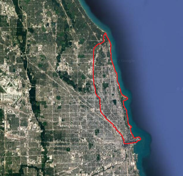
ever since the digging of the north shore channel over a century ago (a canal dug connecting lake michigan to the north branch of the chicago river to help "flush" it out), a good deal of the northside of chicago and most of evanston were turned into a long and skinny man-made "island".

now, absolutely no one actually thinks of this chunk of land as an island (because it's not in reality), but because it is now technically surrounded by water, and because it lines up so closely to manhattan in size/shape, and because it represents a solid chunk of the some of the densest and most urban neighborhoods of chicago, it's only natural to compare the two geographies.


the real manhattan: ~13 miles long x ~2 miles wide = ~23 sq. miles | 2020 pop: 1,694,251 | average density: ~75,000 ppsm

chicago's "manhattan": ~13 miles long x ~2.5 miles wide = ~29 sq. miles | 2020 pop: ~666,000* | average density: ~23,000 ppsm


(*) i had to approximate the population a tiny bit because a couple of census tracts up in evanston at the very northern end don't fully align with the course of the channel, so +/- around 250 people on that figure.


in case anyone wasn't fully convinced yet, NYC is on a completely different level than every other US city.

nice try chicago, thanks for playing
__________________
"Missing middle" housing can be a great middle ground for many middle class families.

Last edited by Steely Dan; Sep 9, 2022 at 6:33 PM.
Reply With Quote
     
     
  #2  
Old Posted Sep 9, 2022, 5:20 PM
Innsertnamehere's Avatar
Innsertnamehere Innsertnamehere is online now
Registered User
 
Join Date: Jan 2010
Location: Hamilton
Posts: 11,598
of course a big difference is that the Loop is not on Chicago's "Manhattan" which limits it's density potential.. but yea, NYC is on it's own level, surprise, surprise.
Reply With Quote
     
     
  #3  
Old Posted Sep 9, 2022, 5:41 PM
Steely Dan's Avatar
Steely Dan Steely Dan is online now
devout Pizzatarian
 
Join Date: Jul 2001
Location: Lincoln Square, Chicago
Posts: 29,832
Quote:
Originally Posted by Innsertnamehere View Post
of course a big difference is that the Loop is not on Chicago's "Manhattan" which limits it's density potential..
yeah, the miss of the loop is certainly a big ding against this comparison.

but in its favor, the milwaukee ave. corridor from the west loop up to avondale is just west from chicago's "manhattan" across the river and has been the hot new trendy "it" section of the city for a couple decades now, in a somewhat similar fashion to brooklyn's rise in new york.

(before any new yorkers get their panties in a bunch, i'm not saying that the milwaukee ave corridor in chicago is physically like brooklyn, just that it has served a similar kind of role within chicago for 20+ years now.)
__________________
"Missing middle" housing can be a great middle ground for many middle class families.

Last edited by Steely Dan; Sep 9, 2022 at 7:29 PM.
Reply With Quote
     
     
  #4  
Old Posted Sep 9, 2022, 6:03 PM
Obadno Obadno is offline
Registered User
 
Join Date: Jan 2010
Posts: 6,615
Actually Central Phoenix is developed along a spine that is pretty close in proximity to Manhattan's dimensions , except maybe wider depending on where you want to cut it off:

Its Roughly 12.7 miles from the southern loop highway around downtown up to the Phoenix mountain preserves (and they even have an angle like the north end of Manhattan and end in higher elevation like the end of Manhattan) its roughly 4 miles (2 miles if you want to reduce it to the "Between the 7's' as many do wide the whole way and contains the oldest neighborhoods tallest buildings and still highest concentrations of employment density in the metro even during the period of our Downtown decline form 1970-2010.

Even the distance between our two main nodesof skyscrapers Midtown & downtown are roughly the same distance apart, depending on where you set down your marker roughly 3-4 miles apart for both. Of course Manhattan is about 20x the density lol!


roughly where all those colored blocks are and between the yellow highways with the mountain preserve on the north end and downtown/Warehouse district on the south tip.

The Neighborhoods are even called, Downtown, Midtown, Uptown, North Central and eventually Sunnyslope at the north end.

Outdated Hand Drawn map of "Midtown" Phoenix


and here you can see downtown to the south and Midtown to the right right around the same distance as Midtown and downtown Manhattan. All of this is not planned, makes me wonder if there is some natural tendency for these sort of distances based on peoples preferences and reasonable travel times? Mnahattan is the way it is due to geographic constraint, Phoenix is obviously not constrained at all other than some small mountains here and there.


Last edited by Obadno; Sep 9, 2022 at 6:17 PM.
Reply With Quote
     
     
  #5  
Old Posted Sep 9, 2022, 6:39 PM
Yuri's Avatar
Yuri Yuri is offline
Registered User
 
Join Date: Sep 2008
Posts: 4,524
Quote:
Originally Posted by Obadno View Post
Actually Central Phoenix is developed along a spine that is pretty close in proximity to Manhattan's dimensions , except maybe wider depending on where you want to cut it off:
I guess Detroit too, with Downtown and New Center.
__________________
London - São Paulo - Rio de Janeiro - Londrina - Frankfurt
Reply With Quote
     
     
  #6  
Old Posted Sep 9, 2022, 6:45 PM
Steely Dan's Avatar
Steely Dan Steely Dan is online now
devout Pizzatarian
 
Join Date: Jul 2001
Location: Lincoln Square, Chicago
Posts: 29,832
Quote:
Originally Posted by Yuri View Post
I guess Detroit too, with Downtown and New Center.
downtown detroit up to new center is only about 3 miles, but if you continue up the woodward corridor to around royal oak, that's closer to the 13 mile mark of manhattan.

in fact, downtown royal oak is almost exactly the same distance north of downtown detroit as downtown evanston is north of downtown chicago (11.75 miles).

i've never noticed that symmetry before. (royal oak and evanston have been compared to each other many times here over the years).
__________________
"Missing middle" housing can be a great middle ground for many middle class families.
Reply With Quote
     
     
  #7  
Old Posted Sep 9, 2022, 6:53 PM
Crawford Crawford is online now
Registered User
 
Join Date: Nov 2003
Location: Brooklyn, NYC/Polanco, DF
Posts: 30,784
Though Detroit is a little different. The apartment district really was Northwest of the core. If Detroit had ever built a real transit system, Woodward would have been the logical first route, but the Dexter/Linwood corridor out towards Southfield would have been a close second.

The Dexter bus line is the second busiest in the city, even today, after 90% of the apartment buildings were leveled. You see slight hints of the old vitality around Dexter Davison, Central HS and the like. Was the Jewish district, then the upper-middle class black district, plus a big gay population in the apartment buildings till the area got crappy.
Reply With Quote
     
     
  #8  
Old Posted Sep 22, 2022, 10:57 PM
wanderer34 wanderer34 is offline
Registered User
 
Join Date: Jan 2006
Location: Miami/somewhere in paradise
Posts: 1,475
Quote:
Originally Posted by Crawford View Post
Though Detroit is a little different. The apartment district really was Northwest of the core. If Detroit had ever built a real transit system, Woodward would have been the logical first route, but the Dexter/Linwood corridor out towards Southfield would have been a close second.

The Dexter bus line is the second busiest in the city, even today, after 90% of the apartment buildings were leveled. You see slight hints of the old vitality around Dexter Davison, Central HS and the like. Was the Jewish district, then the upper-middle class black district, plus a big gay population in the apartment buildings till the area got crappy.
If Detroit ever had a mass transit system like NYC, Chicago, Boston, and DC, then it would've utilized the spoke routes of Fort, Michigan, Grand River, Woodward, Gratiot, Jefferson, and possibly Van Dyke and Livernois. Even a semi-circle route along Grand Blvd from MCS to Belle Isle would've made a lot of sense.

Also, I'm thinking some of the freeways in Detroit would've been utilized like the Jeffries and the Lodge. It's a shame Detroit never developed a mass transit system like the cities aforementioned.
Reply With Quote
     
     
  #9  
Old Posted Sep 22, 2022, 11:08 PM
DCReid DCReid is offline
Registered User
 
Join Date: Jun 2012
Posts: 1,070
Quote:
Originally Posted by wanderer34 View Post
If Detroit ever had a mass transit system like NYC, Chicago, Boston, and DC, then it would've utilized the spoke routes of Fort, Michigan, Grand River, Woodward, Gratiot, Jefferson, and possibly Van Dyke and Livernois. Even a semi-circle route along Grand Blvd from MCS to Belle Isle would've made a lot of sense.

Also, I'm thinking some of the freeways in Detroit would've been utilized like the Jeffries and the Lodge. It's a shame Detroit never developed a mass transit system like the cities aforementioned.
Wiki: "The period from 1800 to 1929 was one of considerable growth of the city, from 1,800 people in 1820 to 1.56 million in 1930 (2.3 million for the metropolitan area). During this period, a new road system had been created in 1805, a regional rail network was constructed, a thriving streetcar network developed and an emerging global motorcar industry was established in the city." [https://en.wikipedia.org/wiki/Transp...litan_Detroit]

I would hope you would know what killed much of mass transit in Detroit...
Reply With Quote
     
     
  #10  
Old Posted Sep 23, 2022, 5:48 PM
iheartthed iheartthed is offline
Registered User
 
Join Date: Oct 2009
Location: New York
Posts: 9,898
Quote:
Originally Posted by wanderer34 View Post
If Detroit ever had a mass transit system like NYC, Chicago, Boston, and DC, then it would've utilized the spoke routes of Fort, Michigan, Grand River, Woodward, Gratiot, Jefferson, and possibly Van Dyke and Livernois. Even a semi-circle route along Grand Blvd from MCS to Belle Isle would've made a lot of sense.

Also, I'm thinking some of the freeways in Detroit would've been utilized like the Jeffries and the Lodge. It's a shame Detroit never developed a mass transit system like the cities aforementioned.
We don't have to wonder what it would look like. They planned it over 100 years ago:


source: https://8woodblog.com/map-envisions-...onder-what-if/
Reply With Quote
     
     
  #11  
Old Posted Sep 23, 2022, 5:51 PM
Steely Dan's Avatar
Steely Dan Steely Dan is online now
devout Pizzatarian
 
Join Date: Jul 2001
Location: Lincoln Square, Chicago
Posts: 29,832
^ rotate that map 90 degrees CCW and it could almost pass for a map of chicago's L, minus the loop.

A damn shame it didn't happen. I wonder to what degree it might've made a difference in Detroit's population collapse.
__________________
"Missing middle" housing can be a great middle ground for many middle class families.
Reply With Quote
     
     
  #12  
Old Posted Sep 23, 2022, 5:58 PM
iheartthed iheartthed is offline
Registered User
 
Join Date: Oct 2009
Location: New York
Posts: 9,898
Quote:
Originally Posted by Steely Dan View Post
^ rotate that map 90 degrees CCW and it could almost pass for a map of chicago's L, minus the loop.
Although it is not quite as symmetrical, superimpose the Detroit People Mover map onto the one above and you've got almost a direct copy lol. I think the 1960s plan was to have the system first planned in the 1910s with the DPM as a loop-like circulator to get people to points around downtown. The circulator became important due to the sunsetting of the Detroit Streetcar system in the 1950s. The DPM was the only part of the system that got built.
Reply With Quote
     
     
  #13  
Old Posted Sep 25, 2022, 4:08 AM
wanderer34 wanderer34 is offline
Registered User
 
Join Date: Jan 2006
Location: Miami/somewhere in paradise
Posts: 1,475
Quote:
Originally Posted by DCReid View Post
Wiki: "The period from 1800 to 1929 was one of considerable growth of the city, from 1,800 people in 1820 to 1.56 million in 1930 (2.3 million for the metropolitan area). During this period, a new road system had been created in 1805, a regional rail network was constructed, a thriving streetcar network developed and an emerging global motorcar industry was established in the city." [https://en.wikipedia.org/wiki/Transp...litan_Detroit]

I would hope you would know what killed much of mass transit in Detroit...
Yes, the auto industry, and especially the Big Three had a hand in not only preventing a subway system from being built in Detroit but ripped a lot of the streetcar lines that permeated in the city.

Quote:
Originally Posted by iheartthed View Post
We don't have to wonder what it would look like. They planned it over 100 years ago:


source: https://8woodblog.com/map-envisions-...onder-what-if/
The map looks nice but my plans would've had one line starting from Royal Oak but it wouldn't be under Woodward, it would have to follow the ROW, then deviate to John R in Detroit before heading to McNichols, and follow Woodward all the way to Downtown, then turn to Fort southwest to Wyandotte, and another route from Fairlane to Downtown (Campus Martius) via Michigan, then a turn south on Woodward, and a quick left along Jefferson to the Grosse Points and possibly to St Clair Shores.
Reply With Quote
     
     
  #14  
Old Posted Sep 9, 2022, 7:37 PM
Randomguy34's Avatar
Randomguy34 Randomguy34 is offline
Registered User
 
Join Date: Apr 2013
Location: Chicago & Philly
Posts: 2,372
Lol because of how many rivers we have that feed back into themselves and the lake, wouldn't most of Chicago count as islands?
Reply With Quote
     
     
  #15  
Old Posted Sep 10, 2022, 12:08 AM
Xing's Avatar
Xing Xing is online now
Registered User
 
Join Date: Feb 2002
Location: Chicago, Illinois
Posts: 15,862
Sounds like there’s still plenty of space for us to stuff more people.
Reply With Quote
     
     
  #16  
Old Posted Sep 10, 2022, 2:05 AM
chris08876's Avatar
chris08876 chris08876 is offline
NYC/NJ/Miami-Dade
 
Join Date: Jul 2013
Location: Riverview Estates Fairway (PA)
Posts: 45,856
Hopefully Chicago will boom again. A ton of potential within the zone indicated as Manhattan for Chicago. One benefit is probally the best bang for the buck in terms of an urban experience. Literally bang for the buck. A NE folk like myself could go there and live like a king whereas say in NYC, same price for a nice unit in Chicago might get one a dirty bathroom stall with a microwave that doesn't work and hardware floor with blood stains. 2k a month can go very far in Chicago rent wise.

An urban bargain if you ask me (minus the crime). But in time, hopefully things will get better.

I'd love to see the city putting up 25-30k units a year. A ton of potential.
Reply With Quote
     
     
  #17  
Old Posted Sep 10, 2022, 6:37 PM
Xing's Avatar
Xing Xing is online now
Registered User
 
Join Date: Feb 2002
Location: Chicago, Illinois
Posts: 15,862
Quote:
Originally Posted by chris08876 View Post
Hopefully Chicago will boom again. A ton of potential within the zone indicated as Manhattan for Chicago. One benefit is probally the best bang for the buck in terms of an urban experience. Literally bang for the buck. A NE folk like myself could go there and live like a king whereas say in NYC, same price for a nice unit in Chicago might get one a dirty bathroom stall with a microwave that doesn't work and hardware floor with blood stains. 2k a month can go very far in Chicago rent wise.

An urban bargain if you ask me (minus the crime). But in time, hopefully things will get better.

I'd love to see the city putting up 25-30k units a year. A ton of potential.
Downtown continues to boom, and of course the northwest side has been growing. I can’t help but feel a boom could be on the horizon, if it hasn’t already begun.
Reply With Quote
     
     
  #18  
Old Posted Sep 11, 2022, 4:21 PM
DCReid DCReid is offline
Registered User
 
Join Date: Jun 2012
Posts: 1,070
Quote:
Originally Posted by Xing View Post
Downtown continues to boom, and of course the northwest side has been growing. I can’t help but feel a boom could be on the horizon, if it hasn’t already begun.
25-30K units per year in Chicago would likely require a construction revival/boom on the south side and west side. This forum has shown some proposals for some redevelopments, like the former Michael Reese Hospital on the near south, but development would have to proceed further south and west on lots that could be redeveloped. It would be interesting to see if that happens over the next few years. I guess it would have to be a renovation similar to the south Bronx in NYC. https://en.wikipedia.org/wiki/South_Bronx
Reply With Quote
     
     
  #19  
Old Posted Sep 23, 2022, 6:07 PM
Randomguy34's Avatar
Randomguy34 Randomguy34 is offline
Registered User
 
Join Date: Apr 2013
Location: Chicago & Philly
Posts: 2,372
I shed a tear every time I see this map. With how rapidly Detroit grew, this would have accelerated the city's growth, maybe even catching up to Chicago's population. The city's streetcar system declined pretty early due to the automobile, maybe it would have been a different story with a subway system. Too many possibilities to think about, not particularly healthy to dwell on them
Reply With Quote
     
     
  #20  
Old Posted Sep 23, 2022, 6:35 PM
Crawford Crawford is online now
Registered User
 
Join Date: Nov 2003
Location: Brooklyn, NYC/Polanco, DF
Posts: 30,784
Detroit's rail system probably wouldn't have looked like that, however.

That map dates to 1918, before the city's great 1920's boom, before New Center, before Midtown, before the great art deco apartment districts in the city's northwest.

Some of the routes are kinda silly. West Fort Street, for a century, has been an almost entirely uninhabited warehouse/industrial corridor. Woodward would obviously be a corridor, but not sure about any of the other routes.
Reply With Quote
     
     
This discussion thread continues

Use the page links to the lower-right to go to the next page for additional posts
 
 
Reply

Go Back   SkyscraperPage Forum > Discussion Forums > City Discussions
Forum Jump


Forum Jump


All times are GMT. The time now is 11:45 PM.

     
SkyscraperPage.com - Archive - Privacy Statement - Top

Powered by vBulletin® Version 3.8.7
Copyright ©2000 - 2024, vBulletin Solutions, Inc.