HomeDiagramsDatabaseMapsForum About
     

Go Back   SkyscraperPage Forum > Regional Sections > Canada


Reply

 
Thread Tools Display Modes
     
     
  #2201  
Old Posted Jun 4, 2021, 4:20 AM
Coldrsx's Avatar
Coldrsx Coldrsx is offline
Community Guy
 
Join Date: Dec 2003
Location: Canmore, AB
Posts: 66,820
Why do I feel like Ottawa is doing 30 years work in 5?
__________________
"The destructive effects of automobiles are much less a cause than a symptom of our incompetence at city building" - Jane Jacobs 1961ish

Wake me up when I can see skyscrapers
Reply With Quote
     
     
  #2202  
Old Posted Jun 4, 2021, 11:17 AM
Beedok Beedok is offline
Exiled Hamiltonian Gal
 
Join Date: Jun 2012
Posts: 6,806
They had all the right of ways and much of the station infrastructure already in place due to the BRT network, so it’s not that complicated to renovate existing lines and stations.
Reply With Quote
     
     
  #2203  
Old Posted Jun 4, 2021, 11:19 AM
J.OT13's Avatar
J.OT13 J.OT13 is offline
Moderator
 
Join Date: Mar 2012
Location: Ottawa
Posts: 24,024
Quote:
Originally Posted by craner View Post
Thanks - massive expansion.
What is the overall budget ?
Stage 1 was $2.1 B. The City went in with an original estimate of $1.8 B, asking for the Feds and Province to pay one third each. They committed the $600 M requested however, estimates were revised to $2.1 B just before the tender went out. The winning bidder was right on target.

The final split ended-up being (Mun/Prov/Fed) $900 M/$600 M/$600 M.

Stage 2 was $4.66 B. Again, the City's estimates were way off. City staff came up with a $3.4 B estimate.

Some background on funding: Municipal Politicians were able to negotiate a better deal on paper, with the initial project scope split three ways ($3 B for Bayshore/Algonquin to Place d'Orleans along Confederation, Bayview to Bowesville along Trillium). The City then added extensions to Trim and the airport spur, requesting the $315 M cost be split 50/50 between the two upper levels of government, which they agreed to do. The City also added the a one station extension to Moodie (near the new DND HQ) along with a new light maintenance and storage yard, which they claimed could be funded through value-engineering of the planned route (good and bad value engineering). The City also added the one station extension south to Limebank for $80 M, split between the Province ($50 M) and local developers ($30 M).

When bids came in, the total cost came to $4.66 B. Bids came in in December 2018 and rushed through Council in late February and early March 2019. There were lots of questions about the Trillium Line (absolute terrible technical bid full of glaring holes, but it was the cheapest!) that City staff would not answer. At the end of the day, both contracts were included within one vote and Council's hands were forced to approve the entire project.

Final split for Stage 2 (Confederation Civil works and Trillium Civil and 30-year maintenance) is around (Feds/Prov/Muni) $1.2B/$1.2B/$2.2B

Stage 2 also included $300 M for 38 additional Alstom Citadis Spirits along the Confederation Line and $106 M to expand Belfast Yard, the Line's main maintenance and operations centre.

In total, Stage 1 and 2 will have cost around $7.16B. This includes the 30 year maintenance for Trillium but not Confederation. I'm unsure how much the upper levels of Government contributed to the addition Confederation Line vehicles and the Belfast Yard expansion, so I can't determine the final split, but needless to say the City will have paid close to half the total cost. That's one of the reasons why they expect 100% funding for Stage 3 to Kanata and Barrhaven.
Reply With Quote
     
     
  #2204  
Old Posted Jun 4, 2021, 11:23 AM
J.OT13's Avatar
J.OT13 J.OT13 is offline
Moderator
 
Join Date: Mar 2012
Location: Ottawa
Posts: 24,024
Quote:
Originally Posted by Beedok View Post
They had all the right of ways and much of the station infrastructure already in place due to the BRT network, so it’s not that complicated to renovate existing lines and stations.
Along Confed, we had about half the RoW with the existing Transitways. Much of it had/has to be built from scratch through extensive tunneling and trenching. The advantage is that we had the space for these new RoW. Very little expropriation.

Along Confederation, all but three stations are complete rebuilds or brand new. On Trillium, five are existing with little upgrades required, and eight are brand new.

But yes, overall, the O-Train network is far simpler than many other transit projects in Canada. However, others like REM, the Skytrain (other than Canada Line and Broadway extension) and the C-Train also extensively used existing RoW.
Reply With Quote
     
     
  #2205  
Old Posted Jun 4, 2021, 11:34 AM
biguc's Avatar
biguc biguc is offline
Registered User
 
Join Date: Mar 2003
Location: pinkoland
Posts: 11,678
Quote:
Originally Posted by J.OT13 View Post
Well, no. The issue is not demand, but frequency. Since 2014, the Trillium's frequency has been 12 minutes. Instead of adding double tracking to raise (maybe double) frequencies, the City opted to instead double the length of trains/platforms. If we were to interline the South end and airport spur, the branches would run at a terrible 24 minute frequency.

Had we raised frequencies at the north end to 6 minutes, maintaining the current 40 meter trains, we could have interlined while achieving the same upgraded capacity.

The City never provided any sort of reasoning for their decision. My guess is that they wanted to stretch the line as far into the suburbs as possible for the cheapest possible price. Longer trains also mean operational savings by only needing half the drivers.

I don't think it will be long before people realize the folly of the City's choices on this.

When I look at the line 4 stump and how it meets the existing transitway, am I crazy for thinking they should (or will) just convert the transitway to rail and have line 4 travel between the airport and VIA station?
__________________
no
Reply With Quote
     
     
  #2206  
Old Posted Jun 4, 2021, 12:54 PM
J.OT13's Avatar
J.OT13 J.OT13 is offline
Moderator
 
Join Date: Mar 2012
Location: Ottawa
Posts: 24,024
Quote:
Originally Posted by biguc View Post
When I look at the line 4 stump and how it meets the existing transitway, am I crazy for thinking they should (or will) just convert the transitway to rail and have line 4 travel between the airport and VIA station?
It's not impossible. Up until now, the City has focused on converting Transitways to rail (+ expanding the Trillium Line), in part because it's a cheap and easy way to get more rail faster.

The issue is that the east-west Transitway, especially in the downtown, had major capacity issues, so the conversion and tunnel were absolutely necessary. The existing s/e Transitway from South Keys to Hurdman is far from reaching capacity, and may never come close, so the justification from a needs, financial and business point of view is not there. However, as we all know, transit projects are not always based on needs and reality, but on getting more votes, so everything is possible.

In terms of operations of the overall system, converting the s/e Transitway would not help in any way. Passengers would still need to be transferred at Hurdman, or the s/e would need to interline at Hurdman (requiring a compelte re-build). If we interline, capacity would be halved east of Hurdman. If we don't, we will still have thousands of people an hour transferring onto already packed trains.

Many of us on the Ottawa forum support a future (20-30 years from now) Bank Street subway from the Airport spur to Parliament station, possibly continuing east under Rideau and Montreal. The argument is that it would serve the densest corridors in the city, but also relieve both the Trillium and Confederation Lines. Both Bayview and Hurdman are major transfers and could become choke points over the next decades. Having the two biggest transfers just outside downtown where trains on your main branch are filled by 20%-30% + just at those stations is not sustainable in the long run.

But the Bank Street subway is a contentious issue. Some support whole hardily, some oppose it vigorously. In any case, the City has never raised that possibility (other than old subway plans from 60-100+ years ago), so it's a moot point.
Reply With Quote
     
     
  #2207  
Old Posted Jun 4, 2021, 1:14 PM
thewave46 thewave46 is offline
Registered User
 
Join Date: Aug 2013
Posts: 3,481
Quote:
Originally Posted by Coldrsx View Post
Why do I feel like Ottawa is doing 30 years work in 5?
They were quite ambitious.

Admittedly, the central section was at least 10 years overdue as Ottawa had outgrown the Transitway through the core some time ago.

Having the right-of-ways made going big possible (especially with Stage 2) and having the provincial and federal governments be in a relatively spendy mood made it possible.

They've gone from almost nothing to covering a large chunk of the city with rapid transit in two fell swoops. I imagine they will be standing pat for awhile after this.
Reply With Quote
     
     
  #2208  
Old Posted Jun 5, 2021, 8:31 AM
biguc's Avatar
biguc biguc is offline
Registered User
 
Join Date: Mar 2003
Location: pinkoland
Posts: 11,678
Quote:
Originally Posted by J.OT13 View Post
It's not impossible. Up until now, the City has focused on converting Transitways to rail (+ expanding the Trillium Line), in part because it's a cheap and easy way to get more rail faster.

The issue is that the east-west Transitway, especially in the downtown, had major capacity issues, so the conversion and tunnel were absolutely necessary. The existing s/e Transitway from South Keys to Hurdman is far from reaching capacity, and may never come close, so the justification from a needs, financial and business point of view is not there. However, as we all know, transit projects are not always based on needs and reality, but on getting more votes, so everything is possible.

In terms of operations of the overall system, converting the s/e Transitway would not help in any way. Passengers would still need to be transferred at Hurdman, or the s/e would need to interline at Hurdman (requiring a compelte re-build). If we interline, capacity would be halved east of Hurdman. If we don't, we will still have thousands of people an hour transferring onto already packed trains.

Many of us on the Ottawa forum support a future (20-30 years from now) Bank Street subway from the Airport spur to Parliament station, possibly continuing east under Rideau and Montreal. The argument is that it would serve the densest corridors in the city, but also relieve both the Trillium and Confederation Lines. Both Bayview and Hurdman are major transfers and could become choke points over the next decades. Having the two biggest transfers just outside downtown where trains on your main branch are filled by 20%-30% + just at those stations is not sustainable in the long run.

But the Bank Street subway is a contentious issue. Some support whole hardily, some oppose it vigorously. In any case, the City has never raised that possibility (other than old subway plans from 60-100+ years ago), so it's a moot point.
Bayview looks like a capacity problem and splitting off rides to Hurdman looks like a decent medium-term way to build in redundancy and share the load. It would also ease the pain of closing Trillium again to double track it. And, that massive parclo by Hurdman looks like a fat land bank when you put two rail lines next to it.


I agree about the Bank Street subway, and I think the 20-30 year timeline is realistic. By then Ottaway will have squeezed all it can from mid-sized city infrastructure and will need a real heavy metro line. A line under Bank, that turns down Montreal and meets the Confederation line at the highway would do big things and comfortably support Ottawa on its way to being a city of several million.
__________________
no
Reply With Quote
     
     
  #2209  
Old Posted Jun 7, 2021, 11:31 AM
J.OT13's Avatar
J.OT13 J.OT13 is offline
Moderator
 
Join Date: Mar 2012
Location: Ottawa
Posts: 24,024
Quote:
Reece Martin
@RM_Transit

A friend in Switzerland sent me this! Excited to see this Stadler Flirt running in Ottawa, hope to see something like it running in Toronto on GO RER soon!

@JimWatsonOttawa @EnglishRail @TheFourFoot @chrisjamesdrew


8:39 PM · Jun 6, 2021·Twitter for iPhone
https://twitter.com/RM_Transit/statu...00332648996869
Reply With Quote
     
     
  #2210  
Old Posted Jun 7, 2021, 1:03 PM
Truenorth00 Truenorth00 is offline
Registered User
 
Join Date: May 2017
Posts: 24,499
Quote:
Originally Posted by biguc View Post
I agree about the Bank Street subway, and I think the 20-30 year timeline is realistic. By then Ottaway will have squeezed all it can from mid-sized city infrastructure and will need a real heavy metro line. A line under Bank, that turns down Montreal and meets the Confederation line at the highway would do big things and comfortably support Ottawa on its way to being a city of several million.
I'm one of those routinely deemed an opponent of a Bank St subway. Mostly though, I'm just a skeptic.

I find that Ottawans tend to think of Bank St as Ottawa's version of Yonge Street. And mostly that derives from its context as a major N-S avenue through the city. However, the current level of development isn't close to enough to support higher order transit investment on its own. And the urban portion and a good bit of the suburban portion is paralleled by a fully grade separated heavy rail corridor (Trillium Line) that is anywhere from a few hundred metres to a max of 2 km away. There would have to be substantial development on Bank to justify a subway at $300M/km when a corridor with even higher potential capacity is so close by. The case for higher levels of government to fund expensive grade separated transit lines less than 2 km apart (with another BRT corridor east of Bank) would truly have to be exceptional.

And I would argue that development isn't coming. I think a lot of Bank St's importance and development derived from its pre-LRT era when it was a major avenue for drivers. But now, we're seeing development shift to around all the LRT stations and Bank St will lose relative importance. The development along the Trillium Line itself will make that corridor rival Bank in some ways in a decade or two.

If this were Europe, a street like Bank might have a tram on it. But Bank St subway candidates tend to insist that the only acceptable solution is grade separation. That really limits them and dooms the corridor to no further investment.
Reply With Quote
     
     
  #2211  
Old Posted Jun 7, 2021, 1:47 PM
J.OT13's Avatar
J.OT13 J.OT13 is offline
Moderator
 
Join Date: Mar 2012
Location: Ottawa
Posts: 24,024
I don't think anyone has delusions that Bank Street is Ottawa's Yonge Street, otherwise we'd be calling for an heavy-rail subway like the TTC and Montreal Metro. What we're advocating is a modest Canada Line type system, or Millennium Line Broadway extension.

The main goal of a Bank subway could be to relieve Hurdman and Bayview, two major transfer stations just outside the downtown. The high volume of transfers at these stations onto largely full trains on the Confederation Line coming in from the suburbs is problematic.

A second goal would be to provide direct to downtown service from the airport and, possibly Riveside South (both currently Stage 2 Trillium extension, but could be transferred to a future Bank Line). This would leave Trillium as it's own, short urban route serving key destinations along the S/E Transitway, Carleton University, the new Civic Hospital and major TOD zones. We would then be ale to limit double tracking to all but the Dow's Lake Tunnel and Rideau River Bridge, resulting in an acceptable 6-8 minute frequency. Ridership of the line before the pandemic was 20,000 per day. I'm confident it could reach close to 50,000 per day, Sheppard Line numbers for a fraction of the price, within 20 years, with South Keys to Bayview only.

The third goal would be to serve density and major destinations. Centretown has a density of around 12,000/square kilometers. The Glebe 5,000. There are about a dozen+ buildings ranging from 6 to 30 floors proposed or u/c all along the corridor between Downtown and Billings Bridge. Bank between downtown and the Rideau River is a near continuous lively traditional main street. Key major destinations within 500 meters are the CBD, the Canadian Museum of Nature, Lansdowne Park (24,000 seat stadium, 10,000 seat arena, Farmer's Market, and restaurant/entertainment district) and Billing's Bridge shopping Centre along the S/E Transitway. Plugging in the airport and Riverside South would increase ridership further.

The reasoning against a streetcar is space. It's a narrow traditional main street with on-street parking. Some sections are only two lanes. There's no room for streetcars and stations. Some propose removing cars, but Bank is only one of two north-south streets in the downtown that reach all the way to suburban areas south of the Rideau River. In fact, Bank goes all the way to the St. Lawrence River.
Reply With Quote
     
     
  #2212  
Old Posted Jun 7, 2021, 1:53 PM
Acajack's Avatar
Acajack Acajack is offline
Unapologetic Occidental
 
Join Date: Aug 2006
Location: Province 2, Canadian Empire
Posts: 68,143
Quote:
Originally Posted by Truenorth00 View Post

If this were Europe, a street like Bank might have a tram on it. .
Bank Street in central Ottawa might not be narrow like typical streets in Toledo, Spain or even Paris, but it's actually quite a bit narrower than those streets in Europe where they put trams.

https://www.google.com/maps/@41.8811...7i16384!8i8192

VS

https://www.google.com/maps/@45.4034...7i16384!8i8192
__________________
The Last Word.
Reply With Quote
     
     
  #2213  
Old Posted Jun 7, 2021, 2:33 PM
hipster duck's Avatar
hipster duck hipster duck is offline
Registered User
 
Join Date: Oct 2014
Location: Toronto
Posts: 4,111
I know investing in an on-street tramway like what you see in Toronto seems foolish in 2021, but I don't think most trips on Bank street take place over a distance where there would be incredible time savings of having trams run in their own ROW, let alone in a tunnel. Bank St. between Wellington and Billings Bridge is about 4.5 km, and most trips along that route will be shorter.

Sometimes all you need is more capacity. A 30m long streetcar can carry about 2.5 times as many people as a 40ft bus, and has 5 generous doors for loading and unloading.

There are only a handful of places in Canada where I would advocate that they build a streetcar, but that short stretch of Bank St. is one of them.
Reply With Quote
     
     
  #2214  
Old Posted Jun 7, 2021, 2:48 PM
swimmer_spe swimmer_spe is offline
BANNED
 
Join Date: Apr 2014
Posts: 10,738
Of the top 10 metros in Canada, Quebec City and Hamilton still don't have any form of RT. At least Winnipeg has their version of a transitway/BRT. Am I right that QC and Hamilton don't have a BRT? I know both cities have plans for an RT. I am wondering who will get theirs last.
Reply With Quote
     
     
  #2215  
Old Posted Jun 7, 2021, 2:50 PM
Beedok Beedok is offline
Exiled Hamiltonian Gal
 
Join Date: Jun 2012
Posts: 6,806
I think Ottawa could handle Bank becoming transit only at sections. North of the Queensway it already closes frequently for festivals and the like, as well as having several parallel streets that can be used. South of the Queensway it’s 4 lanes wide, or wider. That’s easily enough room for surface LRT (as proven by the plans for Hamilton’s B-line which runs down an only slightly less densely developed street).
Reply With Quote
     
     
  #2216  
Old Posted Jun 7, 2021, 3:53 PM
Aylmer's Avatar
Aylmer Aylmer is offline
Still optimistic
 
Join Date: Nov 2007
Location: Montreal (C-D-N) / Ottawa (Aylmer)
Posts: 5,383
Quote:
Originally Posted by J.OT13 View Post

The reasoning against a streetcar is space. It's a narrow traditional main street with on-street parking. Some sections are only two lanes. There's no room for streetcars and stations. Some propose removing cars, but Bank is only one of two north-south streets in the downtown that reach all the way to suburban areas south of the Rideau River. In fact, Bank goes all the way to the St. Lawrence River.
Although, as you point out here, it's a pretty useless route for driving because it's 1-2 excruciatingly slow lanes with intersections every 50 metres over its 5km.

My beef with the Bank Street subway idea is that the longer access times and wider station placement (vs a traffic-free surface option) would mean that, despite have faster-moving trains, an underground line would actually result in longer door-to-door trip times for the downtown-adjacent areas it claims to serve.

Depending on local circumstances, the breakeven for surface vs underground transit is roughly 5 km. Let's say you have a street with a tram (with dedicated lanes) and a subway. The tram has 50% closer station placement, and the subway has an average speed 50% higher.

Let's say you and a friend are doing a transit race to a point 2 km away.

You take the underground and
  • *walk 2.5 minutes to the station (located every 800m, so an avg of 200m)
    *walk 2 minutes down the escalator and concourse to the platform (assuming the tunnel is bored)
    *wait 2 minutes for the subway (4 minute headways)
    *take the train for 3.5 minutes (35 km/h service speed, which includes stops)
    *walk 2 minutes up the escalator and concourse
    *walk 2.5 minutes to point B
In total, it took you 14.5 minutes

Your friend takes the tram and
  • *walks 1 minute to the stop (located every 400m, so avg 100m)
    *has no platform access time because it's at grade
    *waits 2 minutes for the tram (4 minute headways)
    *takes the tram for 6 minutes (20 km/h service speed, including stops and signals)
    *walks 1 minute from the stop
In total, it took them 10 minutes.


The graph above shows the time difference in an overground vs underground system.


This one shows the time difference in percentage of an overground trip. The takeaway is that for shorter trips (<5km), overground transit results in significantly shorter trip times.

Considering the entire length of the urban section of Bank is about 4km, the average overground trip would be at minimum 2 minutes faster than the equivalent underground trip. Some trips will be faster (like if your origin and destination happen to be directly above a station. But for a much more spread-out (or at least not node-based) environment like a central neighbourhood, that's not particularly likely. What's much more likely in an environment like Bank are trips which only use 1-2km of Bank with transfers or walks on both ends. And for those kinds of trips, an underground system just can't perform as well as at-grade transit. In transit as with all things, we've got to choose the right tool for the job. If the job is to maintain car access on Bank Street, then underground is the way to go. If the job is to make transit fast and convenient, overground performs much better for much less.
__________________
I've always struggled with reality. And I'm pleased to say that I won.
Reply With Quote
     
     
  #2217  
Old Posted Jun 7, 2021, 4:10 PM
Truenorth00 Truenorth00 is offline
Registered User
 
Join Date: May 2017
Posts: 24,499
This comes down to the question of what exactly is investment on Bank Street trying to accomplish?

If it's faster regional travel from the southern portions, then a subway is better. But then one can't really argue it's about helping trips along Bank. Not when station spacing will be 1-2 km. And if it isn't about helping Bank, the next logical inquiry is whether a $300M/km subway is really needed under Bank St specifically.

If it's about serving traffic along Bank, the solutions would be heavily biased towards surface running. Be that bus lanes or a tram. Personally, I think Bank should become a tramway till at least the canal, and through N-S traffic forced to the Airport Pkwy/Bronson Corridor. I'm not a fan of paying hundreds of millions of dollars per km just to facilitate a marginal amount of auto traffic through old neighbourhoods like the Glebe.
Reply With Quote
     
     
  #2218  
Old Posted Jun 7, 2021, 4:21 PM
Beedok Beedok is offline
Exiled Hamiltonian Gal
 
Join Date: Jun 2012
Posts: 6,806
Line 2 already exists to provide the rapid transit from the Airport/southern suburbs to downtown. There’s a transfer involved, yes, but eliminating a transfer to Line 1 isn’t worth the cost of building a Bank Street subway. Not when Line 1 is every 5 minutes, and the Little Italy area could easily see a few hotels get built in the future.
Reply With Quote
     
     
  #2219  
Old Posted Jun 7, 2021, 5:17 PM
J.OT13's Avatar
J.OT13 J.OT13 is offline
Moderator
 
Join Date: Mar 2012
Location: Ottawa
Posts: 24,024
Another consideration with Bank are the parking garage accesses and shipping/receiving bays. Closing down the street might not be realistic deepening on the number and locations of those. We also have to consider deliveries for the hundreds of businesses.

Access to Lansdowne is another important factor. Bank and Queen E. are the only two accesses. Queen Elizabeth Drive is often closed for active transportation.

If we were only talking about local Bank (CBD to Lansdowne), than I would say surface should be discussed however, if we're looking at relieving the Confederation Line choke points at Hurdman and Bayview, where you may have a few thousand transferring on already packed trains. And if the Bank Subway extends down Rideau-Montreal, that makes the tunnel route (elevated south of the Rideau and east of St. Laurent) even further beneficial.

Yes, someone from Somerset might walk to the CBD, but if you live at Catherine, the subway is worth while. If you're going to Lansdowne from outside the Glebe, the subway will be appreciated.

Sure the journey up and down the escalators will take a few minutes, but at least you're protected from the hot/cold in part, and increment weather. For me, once I get to the station entrance, I feel like I've arrived. The short journey down (if less than 20 meters) doesn't bother me.

The numerous traffic lights/intersections along Bank would slow down any tram network significantly. Reducing the number of intersections makes it harder for pedestrians to cross.
Reply With Quote
     
     
  #2220  
Old Posted Jun 7, 2021, 6:11 PM
Aylmer's Avatar
Aylmer Aylmer is offline
Still optimistic
 
Join Date: Nov 2007
Location: Montreal (C-D-N) / Ottawa (Aylmer)
Posts: 5,383
Quote:
Originally Posted by J.OT13 View Post
Another consideration with Bank are the parking garage accesses and shipping/receiving bays. Closing down the street might not be realistic deepening on the number and locations of those. We also have to consider deliveries for the hundreds of businesses.
Just for context, north of the Canal, there are only two parking accesses from Bank. New entrances haven't been permitted for decades.

However, it's important to remember that eliminating congestion doesn't necessarily mean eliminating all traffic. The congestion clogging Bank isn't a convoy of delivery vehicles, accessible taxis, and cars heading to a business on Bank. A congestion-free Bank can exist with all of those.

Think of streets like Echo Drive in Ottawa, a popular walking and cycling route which, thanks to a few strategic vehicle restrictions, went from a highly-trafficked street to one which has rid itself of through-traffic without sacrificing local access.

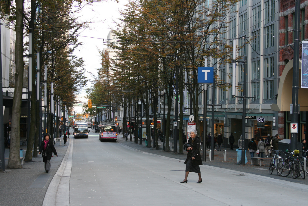
Granville Street in Vancouver is another example of a street which manages to accommodate deliveries, taxis, and other local traffic, but without the kind of through-traffic that would cripple the city's bus spine.


Quote:
Access to Lansdowne is another important factor. Bank and Queen E. are the only two accesses. Queen Elizabeth Drive is often closed for active transportation.
Again, for context, QED has never closed at Lansdowne (for better or worse). It's also worth noting that Lansdowne is a very parking-lite site, containing only 1300 stalls, most of which are actually closed during major events, precisely to avoid overwhelming Bank. When you see 30 000-40 000 people in the stadium, remember that a maximum of 500 of them are using the parking.


Quote:
If we were only talking about local Bank (CBD to Lansdowne), than I would say surface should be discussed however, if we're looking at relieving the Confederation Line choke points at Hurdman and Bayview, where you may have a few thousand transferring on already packed trains. And if the Bank Subway extends down Rideau-Montreal, that makes the tunnel route (elevated south of the Rideau and east of St. Laurent) even further beneficial.
It depends whether this is meant as a crosstown line or not. If it is, as TrueNorth pointed out, it's not a useful line for anyone in the urban sections of Bank or Vanier, who skew much more heavily towards short trips, not long ones. For example:

Quote:
Yes, someone from Somerset might walk to the CBD, but if you live at Catherine, the subway is worth while.
...only barely. For the 1.2km to the CBD, the average journey by subway will take 13 minutes, vs 16 by foot. And that's assuming your origin and destination are within 200m of a station on either end. If they are even just a block and a half over, or if you just missed a train, you'd be faster to walk. Even so, it's a tough sell to ask $3.65 to save (potentially) 3 minutes. Even more to pay billions for the privilege.


Quote:
Sure the journey up and down the escalators will take a few minutes, but at least you're protected from the hot/cold in part, and increment weather. For me, once I get to the station entrance, I feel like I've arrived. The short journey down (if less than 20 meters) doesn't bother me.
Protection from the elements is very important. But you shouldn't have to choose between good transit trip times and weather protection. There are lots of things that can be done at grade to heat and cool passengers. It is important to remember however that, under or at-grade, this would be a high-frequency route. You probably wouldn't be waiting more than 2-3 minutes most of the day. In fact, the added distance between underground stations would mean that an underground system might actually require you to spend more times in the elements, not less.


Quote:
The numerous traffic lights/intersections along Bank would slow down any tram network significantly. Reducing the number of intersections makes it harder for pedestrians to cross.
Bank doesn't have a lot of significantly-trafficked cross-streets. Really only four streets south of the core, the rest being local streets. If Bank were limited to transit vehicles, deliveries, and local traffic on two lanes, it would become significantly easier to cross on foot.
I'll go back to Vancouver's Granville Street, which is constantly being criss-crossed comfortably and safely by pedestrians. This elderly lady certainly doesn't appear displeased by the experience:

__________________
I've always struggled with reality. And I'm pleased to say that I won.
Reply With Quote
     
     
This discussion thread continues

Use the page links to the lower-right to go to the next page for additional posts
 
 
Reply

Go Back   SkyscraperPage Forum > Regional Sections > Canada
Forum Jump


Forum Jump


All times are GMT. The time now is 5:39 AM.

     
SkyscraperPage.com - Archive - Privacy Statement - Top

Powered by vBulletin® Version 3.8.7
Copyright ©2000 - 2024, vBulletin Solutions, Inc.