HomeDiagramsDatabaseMapsForum About
     

Go Back   SkyscraperPage Forum > Photography Forums > Found City Photos

Reply

 
Thread Tools Display Modes
     
     
  #18261  
Old Posted Dec 14, 2013, 5:41 PM
GaylordWilshire's Avatar
GaylordWilshire GaylordWilshire is offline
Registered User
 
Join Date: Nov 2009
Location: NYC
Posts: 3,703


Fantastic, Eric. Was there a date to the cityscape picture? Don't remember. John Parkinson's own house stood at 600 St. Paul at the s/e corner of 6th St. until 1925. We've seen it here before... there's a a bit of mystery to it because it seems to have been moved, but to where?


http://losangeleshistory.blogspot.co...tories_12.html
Reply With Quote
     
     
  #18262  
Old Posted Dec 14, 2013, 7:25 PM
Martin Pal Martin Pal is offline
Registered User
 
Join Date: Sep 2013
Posts: 2,452
Culver City - Palms - Ivy

Here's a related post to the recent ones about the Culver City transit station:

Ivy Station, 1905
http://forum.skyscraperpage.com/show...postcount=8857
Reply With Quote
     
     
  #18263  
Old Posted Dec 14, 2013, 9:18 PM
Martin Pal Martin Pal is offline
Registered User
 
Join Date: Sep 2013
Posts: 2,452
Plummer Park - Great Hall / Long Hall


Photo by Joel H. Mark/West Hollywood Preservation Alliance

Quotes below from this link: L.A. Conservancy

The West Hollywood City Council voted 3-2 in December 2013 to proceed with plans to demolish the WPA-era Great Hall/Long Hall in Plummer Park, despite widespread public outcry and the structure’s National Register status.


Local advocacy groups "Protect Plummer Park" and the "West Hollywood Preservation Alliance" have been working together to oppose the city’s proposal to demolish Great Hall/Long Hall. The city’s proposed $41 million redesign and renovation of Plummer Park calls for the construction of a 179-space underground parking garage in the center of the park, the demolition of Great Hall/Long Hall for a patch of lawn, and the significant alteration of Fiesta Hall as a performance center that would destroy its original design.

Newspaper clipping, 1938:
LAT / Living New Deal
The caption says: Reminiscent of early Southland mission history from which it springs is the new Plummer Park clubhouse at Santa Monica Blvd. and Vista St., where centered gay dedicatory ceremonies yesterday which attracted hundreds of civic and church leaders.

Re: [plans call for] construction of a 179-space underground parking garage in the center of the park...

...All I can think of is the Pershing Square park--before and after.
Reply With Quote
     
     
  #18264  
Old Posted Dec 14, 2013, 10:11 PM
Martin Pal Martin Pal is offline
Registered User
 
Join Date: Sep 2013
Posts: 2,452
Paul Ecke Ranch - Poinsettias

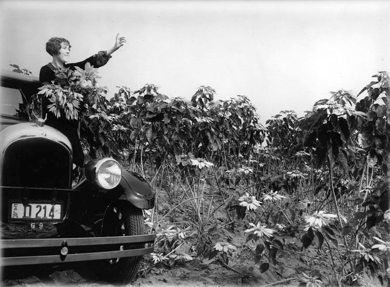
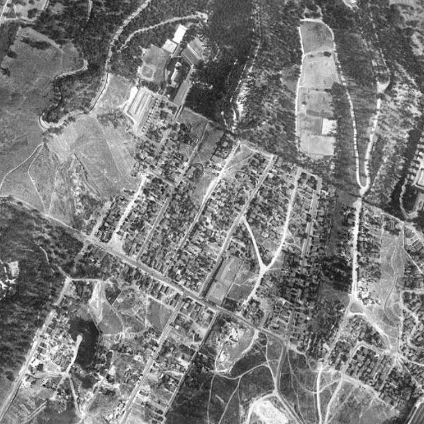
On occasion I have read that before the Beverly Hills Hotel was built that this area around Sunset Blvd. was home to "orchards and poinsettia fields" and that this is where Paul Ecke first began his lucrative poinsettia business.

This LINK says: "...by 1923 the pressures of a rapidly urbanizing Hollywood led Paul Sr. to move the operation to 40 acres in Encinitas."

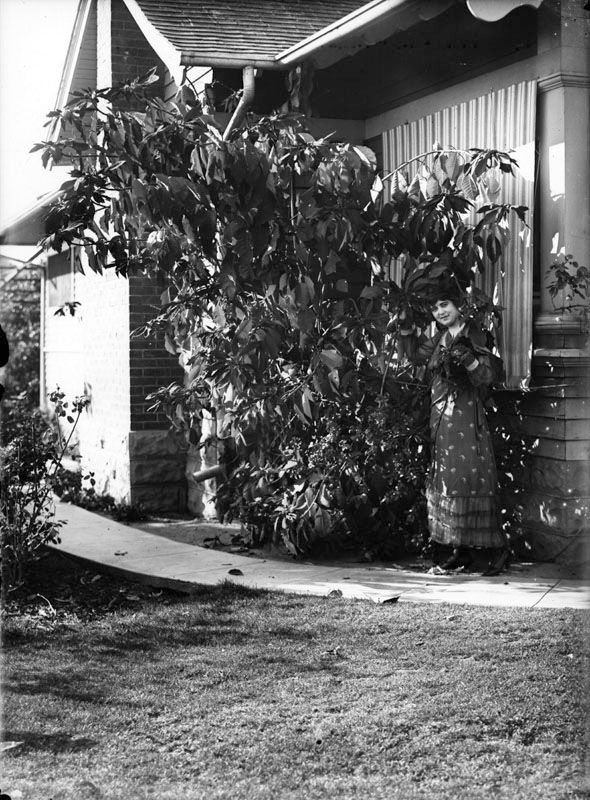
I have been trying to find some historic photographs of these "poinsettia fields" but haven't had any luck doing so. Apparently the Ecke family discovered that these plants grew wild in the area and subsequently made a career of it. We are accustomed to the potted poinsettia plants each year, but I once saw, in Culver City, a backyard that was surrounded by poinsettia bushes and it blew my mind. Absolutely fantastic. (If "bushes" is the right word.) And it makes sense why there's a street called "Poinsettia Place" in Los Angeles, I would guess.

Alas, after a century, the current Eckes family wasn't interested in carrying on the tradition so they sold out last year to a Dutch company, I believe I read.

Since it's the season for them, I thought I'd enlist the help of anyone else who might be able to find a photo or two of the poinsettia fields on Sunset. I believe that KCET once aired a program (probably California's Gold) about the Paul Ecke ranch and it seems they must've shown a photograph or two of what I'm talking about, but it's possible they only mentioned it.
Reply With Quote
     
     
  #18265  
Old Posted Dec 14, 2013, 10:46 PM
HossC's Avatar
HossC HossC is offline
Registered User
 
Join Date: Aug 2013
Posts: 4,245


Martin Pal, you were probably after some aerials or wider views, but here are three pictures from LAPL. The captions are copied directly from that site.

"Miss Peggy Pender stands on the running board of a car with an armful of poinsettias as she looks of a field of the flowers which are grown by Paul Ecke. Located on Sunset Blvd. near Doheny in West Hollywood."


lapl.org

"Miss Peggy Pender examins the flowers of a large poinsettia plant growing beside a building located in West Hollywood. The flowers are grown by Paul Ecke."


lapl.org

"Miss Peggy Pender examins the flowers of a large poinsettia plant growing beside a building located in West Hollywood. The flowers are grown by Paul Ecke."


lapl.org
Reply With Quote
     
     
  #18266  
Old Posted Dec 14, 2013, 11:01 PM
Godzilla Godzilla is offline
Registered User
 
Join Date: Sep 2012
Posts: 725
Quote:
Originally Posted by Godzilla View Post
I am returning to the subject of "Poinsettia" Drive and Place. Some might find it interesting to note that not far away, Poinsettias were grown commercially. While I do not have a specific address for the Farm, it was close to another interesting streamline moderne style apartment complex. The once-called Doheny View Terrace was located at 9231 North Doheny Road at the corner of Sunset Hills Road in what is now West Hollywood. It was not my intention to name drop, but according to the source notes, Markowitz & Sons Inc. designed the 1936 building and celebrities such as Eva Gardener and Mickey Rooney once resided there. The building still exists today wearing a different trim color. "Somewhere" close by, as indicated by one of the photos, there was a Poinsettia farm.

1937:


lapl


You beat me to the poin[t]settia, HossC!

Last edited by Godzilla; Dec 15, 2013 at 12:19 AM.
Reply With Quote
     
     
  #18267  
Old Posted Dec 15, 2013, 12:07 AM
MartinTurnbull's Avatar
MartinTurnbull MartinTurnbull is offline
Registered User
 
Join Date: Oct 2011
Location: Los Angeles
Posts: 223
[QUOTE=Tetsu;6336944]
Quote:
Originally Posted by oldstuff View Post


WS1911 - That's really cool you had the opportunity to talk to Charles Pinney personally. Wish I could've, didn't learn about Angelino Heights until the late 80's when my mom told me about it to help feed my growing interest in LA's classic architecture.

oldstuff, great info! The entry on the Pinney House on Big Orange Landmarks indicates that Charles Pinney did live in the house until he died, though it gives 1980 as the year of his death.

Also, GaylordWilshire, that's interesting to think about the possible connection to the Pinney House in Sierra Madre. Never clicked in my mind that the last name was the same.
We recently saw the Pinney house in the last episode of the latest season of "Mad Men" - it played the role of "whorehouse" where Don Draper lived as a kid.


Uploaded with ImageShack.us
Reply With Quote
     
     
  #18268  
Old Posted Dec 15, 2013, 12:11 AM
MartinTurnbull's Avatar
MartinTurnbull MartinTurnbull is offline
Registered User
 
Join Date: Oct 2011
Location: Los Angeles
Posts: 223
Quote:
Originally Posted by Martin Pal View Post
In David Stenn's biography, Runnin' Wild, of Clara Bow:

Producer Budd Schulberg says, "Coop might have been the Babe Ruth of the Hollywood boudoir league. It was whispered down the studio corridors that he had the endowments of Hercules and the staying powers of Job."
page 91

His wife attested that "he had many girlfriends." "At the time, tales of the star who spoke softly but carried a big stick spread despite his gentlemanly silence."
page 91

About the line you quote: It was purportedly told to Hedda Hopper who had inquired about her affair with Cooper. "Accurate or apocryphal?" writes Stenn. He personally interviewed actresses Esther Ralston and Lina Basquette and Tui Lorraine Bow, a good friend of Clara's who had married Clara's father, though was younger than Clara, and they all concur on it's validity as "She said things like that all the time" and "She and Gary had a pretty hot affair and Clara talked about it a lot."
page 94

Clara Bow's IT CAFE on Vine Street at the Hollywood Plaza Hotel:


felixinhollywood

Matchbook:

Askville
I've recently learned the Phil Selznick (aka David O. Selznick's uncle and owner of the Mocambo and the Sphinx Club) took over the It Cafe and was wondering if anybody knew when.


Uploaded with ImageShack.us
Reply With Quote
     
     
  #18269  
Old Posted Dec 15, 2013, 12:25 AM
Those Who Squirm!'s Avatar
Those Who Squirm! Those Who Squirm! is offline
Registered User
 
Join Date: Jan 2011
Location: In my specially built chair
Posts: 376
Quote:
Originally Posted by GaylordWilshire View Post
:GRUMBLE:

Has anyone noticed that in its "if it ain't broke, fix it" redesign, Google Street View has become as clunky to use as Bing? Is it just me?
GSV seems fine to me, but aerial views in Google seem to be horrible these days; many of the blobs never resolve into buildings, not even greyscaled. To get a good overhead or bird's eye view I have to go to Bing, but for street level views I think Google is still better, and it covers more.

Probably some of it has to do with my computer's age, but then we're still talking about a company that took the "Add To Contacts" function out of Google Maps.
__________________
The new Wandering In L.A. post is published!

This Is Probably The Oldest Intact School Building In L.A.
Reply With Quote
     
     
  #18270  
Old Posted Dec 15, 2013, 1:39 AM
HossC's Avatar
HossC HossC is offline
Registered User
 
Join Date: Aug 2013
Posts: 4,245
Quote:
Originally Posted by GaylordWilshire View Post
Was there a date to the cityscape picture? Don't remember.
The USC Cityscape picture is undated, but we can narrow down the possible dates. I recently posted the section showing the Tanner Motor Livery building, which means that the photo was taken after 1926 (its build date). I also mentioned that it's before the eastern end of Wilshire was widened. LAPL's road widening pictures (like the one gsjansen posted here) seem to be dated 1936, but USC's pictures say 1934.

NB. Kip Street was a short street to the east of Bixel that linked 7th and Wilshire, and also intersected with Ingraham. It disappeared when the Harbor Freeway was built.

The building just left of center with its wall missing is the Rex Arms.

"View of post-widened Wilshire Boulevard looking east fifty feet from Kip Street, 1934"


USC Digital Library

"View of post-widened Wilshire Boulevard looking west from a point fifty feet east of Bixel Street, 1934"


USC Digital Library

I'm sure there are more clues to the exact date of the Cityscape if we look carefully!
Reply With Quote
     
     
  #18271  
Old Posted Dec 15, 2013, 2:39 AM
FredH's Avatar
FredH FredH is offline
Registered User
 
Join Date: Aug 2011
Posts: 676
1963 Baldwin Hills Dam Collapse

The L.A. Times is running a nice photo spread on the 1963 Baldwin Hills Dam disaster today:


L.A. Times

Check it out. Its worth a look.

http://framework.latimes.com/2013/12...m-collapse/#/0
(run your cursor up the right side of the photos to click on to the next one)

Gaylord Wilshire: Along with Google Street View I am also contending with a totally worthless ImageShack update that I have to avoid every time I log in there. Geez!
Reply With Quote
     
     
  #18272  
Old Posted Dec 15, 2013, 3:42 AM
CASIGNS's Avatar
CASIGNS CASIGNS is offline
Registered User
 
Join Date: Nov 2010
Location: Sacramento, CA
Posts: 15
Date in Retaing Wall

Quote:
Originally Posted by GaylordWilshire View Post


No mention of the Oliver house, but there's a good bit of detail in this article from the Times of Sept 26, 1954:


LAT
I am intrigued with the 1886 date in the W 4th St retaining wall pictured in this LA Times article. Does anyone know if this wall and date still exists or is it long gone?
Reply With Quote
     
     
  #18273  
Old Posted Dec 15, 2013, 5:58 AM
Tetsu Tetsu is offline
Registered User
 
Join Date: Aug 2013
Posts: 180
Sisters Of The Society Of Mary Convent

Question for those of you with old maps of LA: What do you guys know about Paducah Street in the Elysian Park/Chavez Ravine area? Was browsing LAPL and found some pictures of the Sisters Of The Society Of Mary Convent, an intriguing Victorian building that probably started its existence as a single family house, if I had to guess:

LAPL

Effie Street still exists, running through Elysian Park and Echo Park, terminating and continuing at various points throughout, but Paducah Street seems to have vanished completely, along with this building, I'm pretty sure. Can anybody point out its former location on an older map of LA?

One more view of the rear of the building:

LAPL

Pictures are dated 1951.
Reply With Quote
     
     
  #18274  
Old Posted Dec 15, 2013, 7:07 AM
Tetsu Tetsu is offline
Registered User
 
Join Date: Aug 2013
Posts: 180
Stumbled onto a photo that makes me pretty sad, but it's a hell of a find so I figured I'd better post it anyway.

(Don't think I've seen it posted here yet, so my apologies if it has!)


Construction of the 4th Street viaduct, photo dated 1956. Photo is looking west along 4th from the corner of 4th & Olive. In the foreground we see the steps that once led up to the Fremont Hotel. In the background you can clearly make out The Salt Box. Next to it you can see what I think is the roofline of its neighbor at 333 S. Bunker Hill Ave. You can also see the Stuart Oliver house (just to the right of the top center) and the site of the Hildreth mansion next door.

Correct me if I'm wrong but wasn't the viaduct built from 1954-56? I'd guess this photo was taken in 1954, as it looks like they haven't actually started digging out the road or leveling out the ground yet.
Reply With Quote
     
     
  #18275  
Old Posted Dec 15, 2013, 8:03 AM
sadykadie2 sadykadie2 is offline
Registered User
 
Join Date: Jun 2013
Posts: 148
Have I died and gone to heaven? All my life I've been obsessed with architecture--photographing old buildings as a very young adult, trying in vain to interest my family. Now I've found it--a website full of pictures that make my brain light up like a Christmas tree. A website full of people as excited about old buildings as I am!
Reply With Quote
     
     
  #18276  
Old Posted Dec 15, 2013, 8:13 AM
sadykadie2 sadykadie2 is offline
Registered User
 
Join Date: Jun 2013
Posts: 148
Hate the new Google maps HATE IT! I'm on it often ,looking up old building sites and it's so hard to use now! The aerial maps are really hard to navigate
Reply With Quote
     
     
  #18277  
Old Posted Dec 15, 2013, 8:23 AM
sadykadie2 sadykadie2 is offline
Registered User
 
Join Date: Jun 2013
Posts: 148
Quote:
Originally Posted by AlvaroLegido View Post
Fred Please ! Don't wait for 3 photos to let us know you're kidding. I thought for a minute there was a traitor among noirishers.
Fred, you're killin' me!
Reply With Quote
     
     
  #18278  
Old Posted Dec 15, 2013, 11:33 AM
HossC's Avatar
HossC HossC is offline
Registered User
 
Join Date: Aug 2013
Posts: 4,245
Quote:
Originally Posted by Tetsu View Post
Question for those of you with old maps of LA: What do you guys know about Paducah Street in the Elysian Park/Chavez Ravine area? Was browsing LAPL and found some pictures of the Sisters Of The Society Of Mary Convent, an intriguing Victorian building that probably started its existence as a single family house, if I had to guess:

LAPL

Effie Street still exists, running through Elysian Park and Echo Park, terminating and continuing at various points throughout, but Paducah Street seems to have vanished completely, along with this building, I'm pretty sure. Can anybody point out its former location on an older map of LA?
The Baist maps show Paducah Street as Paloverde Street. Here's how the area developed between 1910 and 1921. It looks like many of the planned streets never got built.

1910:

www.historicmapworks.com

1921:

www.historicmapworks.com

Paducah Street does appear on this 1928 street map (I'm sure I found this map through NLA, but I can't remember where). There now seems to be a second section of Paducah Street extending south-west.


Probably for clarity, the map above omits the short, diagonal Curtis Street. The aerial below shows that it was still there in 1948.


Historic Aerials

This aerial dates from 2004, and I'm finding it hard to see many features that survive. The red lines mark where Paducah Street once stood.


Historic Aerials


------------------------


Quote:
Originally Posted by FredH View Post
Gaylord Wilshire: Along with Google Street View I am also contending with a totally worthless ImageShack update that I have to avoid every time I log in there. Geez!
I wish these sites would take notice of the number of users who continue to revert to the old layout during these "updates". Photobucket needlessly ruined their interface a while back, and although they've put a few features back, it's still not as good as it used to be. I've also had to put up with pointless "improvements" to Hotmail and GMail in the last year.
Reply With Quote
     
     
  #18279  
Old Posted Dec 15, 2013, 1:43 PM
GaylordWilshire's Avatar
GaylordWilshire GaylordWilshire is offline
Registered User
 
Join Date: Nov 2009
Location: NYC
Posts: 3,703
LAT Nov 15, 1887

"Uxoricide" is a term new to me...
Reply With Quote
     
     
  #18280  
Old Posted Dec 15, 2013, 2:17 PM
GaylordWilshire's Avatar
GaylordWilshire GaylordWilshire is offline
Registered User
 
Join Date: Nov 2009
Location: NYC
Posts: 3,703
Quote:
Originally Posted by sadykadie2 View Post
Hate the new Google maps HATE IT! I'm on it often ,looking up old building sites and it's so hard to use now! The aerial maps are really hard to navigate

Found this--https://support.google.com/maps/answer/3045828?hl=en--there is an option to revert back to the old Google Maps "permanently" however long permanently is in Google terms.
Reply With Quote
     
     
This discussion thread continues

Use the page links to the lower-right to go to the next page for additional posts

Reply

Go Back   SkyscraperPage Forum > Photography Forums > Found City Photos
Forum Jump


Forum Jump


All times are GMT. The time now is 11:15 AM.

     
SkyscraperPage.com - Archive - Privacy Statement - Top

Powered by vBulletin® Version 3.8.7
Copyright ©2000 - 2024, vBulletin Solutions, Inc.