Not really “Future Plans”, but Kitchissippi’s comment, in the Confederation Line West LRT thread, about fully automated Metro from Lincoln Fields to Hurdman makes me think about how I would have liked to see things develop in the past.
My dream probably would have cost a bit more, since I would have done a bit more tunnelling. However, I would have made all of the tunnels using Cut & Cover (except in areas where it was impractical) to lower cost and make the stations much shallower. In hindsight, the roads were so disrupted by the LRT construction anyway, there was little benefit in doing the expensive mining.
The big changes I would have made would be planning for the Central Library / LAC to be on the other side of a re-aligned Albert, with an integrated below grade LRT station; the line running under Slater (instead of Queen); putting the uOttawa and Lees Stations underground; and tunneling through the Hurdman wasteland, and under Riverside Drive. (I chose Slater as that was the road that the old 1970s plan chose because the infrastructure under Slater needed to be replaced anyway; so, a Cut & Cover tunnel could be done at the same time, more cost effectively.)
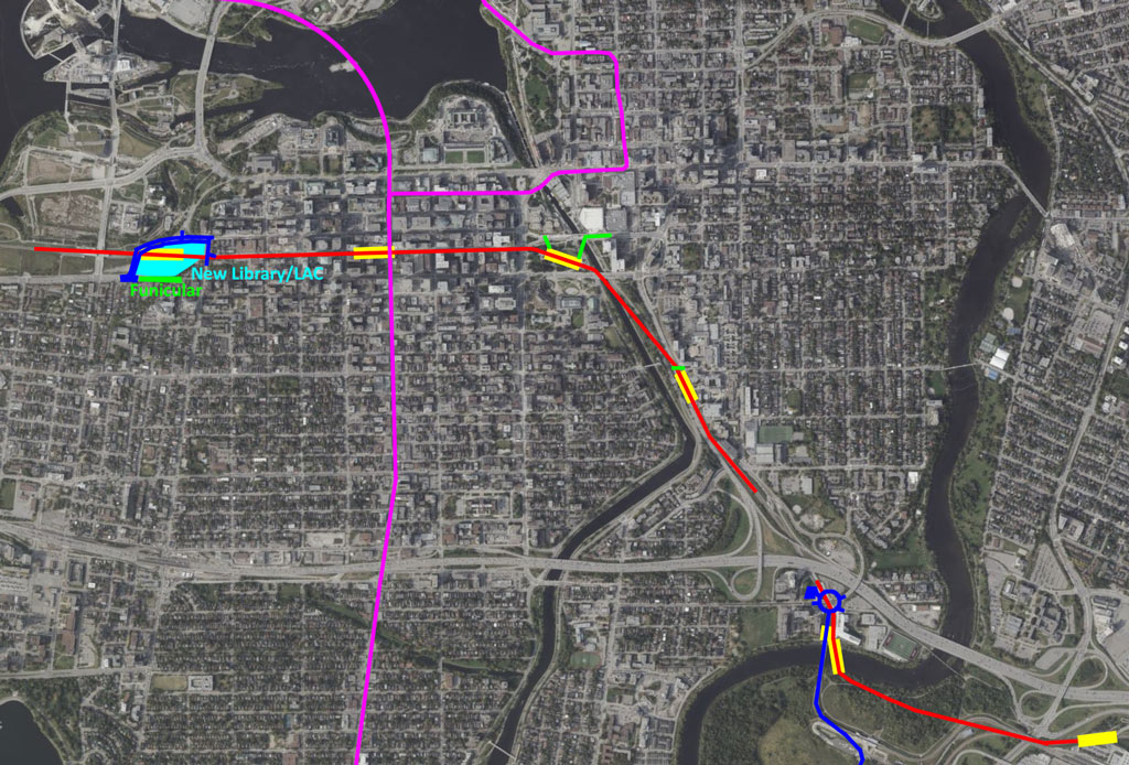
Notice in the graphic, that the Confederation Line (in red) no longer goes to Rideau. Since most of the travelers on that line were not destined for the By Ward Market, I skipped that detour. Access to the Rideau Centre is provided through a pedestrian tunnel under the canal. The re-routed Trillium Line (fuchsia line along Bank) covers The Market.
Ideally, the Bank Street Subway would have been built as a shallow line, just under the new infrastructure, when Bank was completely dug-up from Wellington through the Glebe. There could have been side platforms, accessible via stairs and a small elevator on each of the four corners of an intersection – thus providing redundant access by simply crossing a side street.
As drawn, the Bank Street route could be below or at grade. I have also shown a possible branch across the Ottawa River. If this is a subway, it could include both Lines 2 and 4, splitting them at Sparks, with, say, Line 2 going directly to the government buildings.
Stating at the west, I would have the line descending underground before Booth Street. The Pimisi Station has been moved under the new library. Booth Street could have been MUCH less elaborate. The Central Library would have backed into the hill, and provided access from the upper and lower levels – and added a funicular at the end of Laurier Ave (just for the FUN of it).
There is a transfer station between the LRT lines under Bank Street, and another underground station under Confederation Park. That station would have pedestrian tunnels to the NAC (through its underground parking) and a longer one to the Congress Centre and Rideau Centre (probably ending at the Rideau Centre - DND HQ underpass).
The uOttawa Station is now underground (likely under Nicholas with an underpass of Nicholas at each end). The train then emerges as the ground drops and uses the existing 417 underpass. However, it does not turn as sharply to use the existing Transitway ramp to the river crossing. The train stays below grade and passes under the Rideau River through a station that spans the river. (Yes, this will be complex; but it is do-able.) This station provides access from the Lees Campus, and any future development at Hurdman.
Notice that I have completely removed a separate station at Hurdman and the associated bus facilities. I simply have the SE Transitway buses continue to a transfer point at Lees Station. The road surface (Transitway) would no longer drop to below grade north of the bridge, but would stay at grade and intersect with Lees Avenue (likely at a roundabout, since there would be several converging roads). A bus lay-up would be provided there, freeing up most of the land at Hurdman. Buses could, if needed, continue north on Lees and King Edward.
I would have kept the train underground through Hurdman Field and under Riverside Drive. Yes, I know that there is a large pipe there, but I expect that a Cut & Cover tunnel could still go under it.


 Prev
Prev


 Linear Mode
