Quote:
Originally Posted by the urban politician

^ Exactly. I'm wondering if some of the commentors know what they are looking at--that's not the Wacker Drive cut through that cars will be passing though regularly. This is literally the lowest level of the complex--a simple tunnel connecting the Chicago riverwalk to the Lakeshore East neighborhood.
It's more than tall enough for passengers, vehicles, etc. I don't think pictures give justice to the true ceiling height if you were walking through there in person.
|
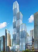
Much of Lake Shore East has 3 levels of street access which is what allows it to be one of the nations most dense collection of high rises.
Wiki link.. Area marked with "fence" is where current Vista's Field Blvd underpass is.
This is not up to date since the Riverwalk is now extended along the river bank all the way to lake front trail with an underpass for LSD.


 Threaded Mode