HomeDiagramsDatabaseMapsForum About
     

Go Back   SkyscraperPage Forum > Discussion Forums > City Discussions


Reply

 
Thread Tools Display Modes
     
     
  #81  
Old Posted Jan 30, 2023, 6:00 PM
McBane McBane is offline
Registered User
 
Join Date: Sep 2006
Location: Philadelphia
Posts: 3,718
I've always been fascinated by the hard edges separating country from city. Don't see that at all up in the northeast.

I think the first time I noticed this was on a trip to Israel a long time ago. Here's a great "hard edge" example in the southern city of Be'er Sheva.
Reply With Quote
     
     
  #82  
Old Posted Jan 30, 2023, 6:13 PM
digitallagasse digitallagasse is online now
Registered User
 
Join Date: Sep 2018
Location: Henderson, NV
Posts: 104
Quote:
Originally Posted by sopas ej View Post


I don't know if this has anything to do with it, but I thought Nevada was the state that has the most land owned by the federal government, like 85% or something? Maybe that's why Las Vegas is is surrounded by no development, apart from it being in the middle of a desert of course.
For Vegas is is a combo of government owned land and water. Land sales do happen and is why development has been able to expand where it is. For water all developments have two options. Either they use ground water or tap into the infrastructure getting water from and then back to the Colorado river. Ground water is very limited and hence why not much happens outside the Las Vegas valley. For the piped water things have slowly expanded but are now reaching the base of the mountain ranges that mostly circle the valley.

Even if large tracts of land outside the Las Vegas valley were available for development not much would happen due to lack of water. Coyote Springs is a perfect example of this. They have the land but don't have the water and hence not much has happened. A rural community without much water has little options to even exist let alone persist.

Note for Colorado river water that the waste water is sent back to treatment plants and then back to Lake Mead. For water used in homes and businesses 90% of the waste water recovered and sent back to the lake. So at least that water use is mostly solved. In simple terms if the waste water flows into the server system then 90% gets recovered. It if doesn't then it is mostly lost to evaporation. Las Vegas uses more river water than it has allocated and has for decades. The trick is that it gets a credit for all the water it sends back.
Reply With Quote
     
     
  #83  
Old Posted Jan 30, 2023, 6:20 PM
digitallagasse digitallagasse is online now
Registered User
 
Join Date: Sep 2018
Location: Henderson, NV
Posts: 104
Gated sub-division on the edge of nothing in Las Vegas.

https://www.google.com/maps/@36.3261...7i13312!8i6656
Reply With Quote
     
     
  #84  
Old Posted Jan 30, 2023, 9:36 PM
edale edale is offline
Registered User
 
Join Date: Apr 2017
Posts: 2,225
Quote:
Originally Posted by jmecklenborg View Post
Yeah. You never get a sense for how huge Atlanta is until you fly out of the place at night. It just keeps...going. Tons of developments hidden in the trees.

Obviously, the approach to LAX from the east covers 40+ miles of sprawl, but there aren't trees hiding it at ground level like is typically the case anywhere east of Oklahoma.
I guess I haven't flown in the right direction out of Atlanta. Last time I flew out of there I remember thinking how quickly everything turned rural. Looking at Google Maps, development does end pretty quickly to the west of the airport, so that must've been the direction we took off. Atlanta's sprawl to the north and south is indeed vast, though.
Reply With Quote
     
     
  #85  
Old Posted Jan 31, 2023, 2:46 AM
ChiSoxRox's Avatar
ChiSoxRox ChiSoxRox is offline
Registered User
 
Join Date: Mar 2007
Location: Boston, MA
Posts: 2,496
Quote:
Originally Posted by edale View Post
I guess I haven't flown in the right direction out of Atlanta. Last time I flew out of there I remember thinking how quickly everything turned rural. Looking at Google Maps, development does end pretty quickly to the west of the airport, so that must've been the direction we took off. Atlanta's sprawl to the north and south is indeed vast, though.
Flightradar24 has a live map that shows this nicely. The westbound route takes less than ten minutes to get past Newnan to rural woods. But heading to the Northeast, the flight path will curve back over Atlanta itself, Gwinnett County sprawl, and perhaps Gainesville sprawl -- 50 miles from the airport.
__________________
Like the pre-war masonry skyscrapers? Then check out my list of the tallest buildings in 1950.
Reply With Quote
     
     
  #86  
Old Posted Jan 31, 2023, 4:34 AM
sopas ej's Avatar
sopas ej sopas ej is offline
Registered User
 
Join Date: Jul 2007
Location: South Pasadena, California
Posts: 6,863
It's interesting to me, this transition/perceived transition between metros.

Being that I'm from the Los Angeles area, I tend to measure things in drive time---and of course in miles, too. Being that I know the scale/distances of Greater LA, I thought I'd do some population 2020 Census density maps to scale in comparison to LA.

Greater LA.


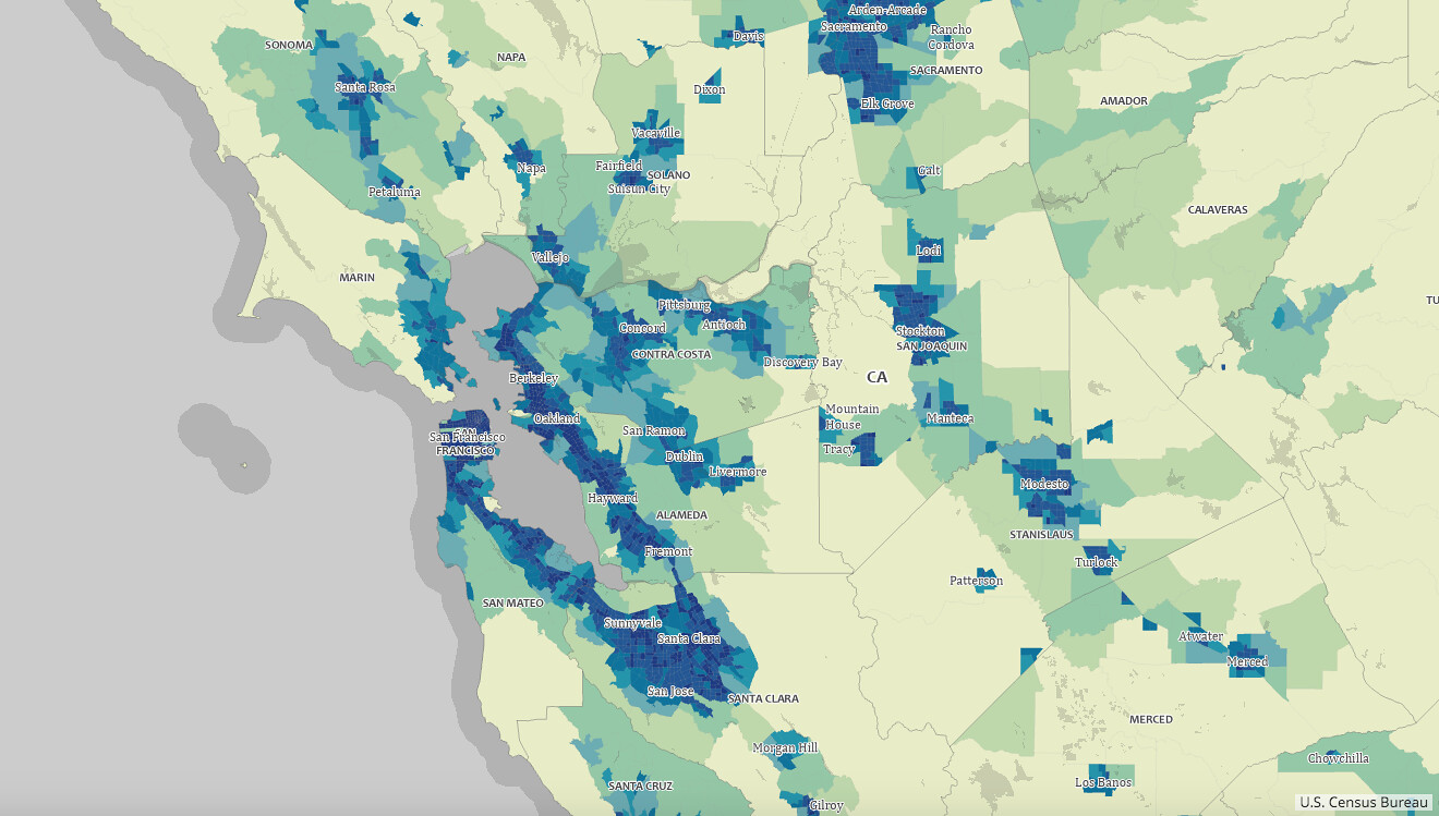
San Francisco Bay Area.


Here's Milwaukee-Chicago.


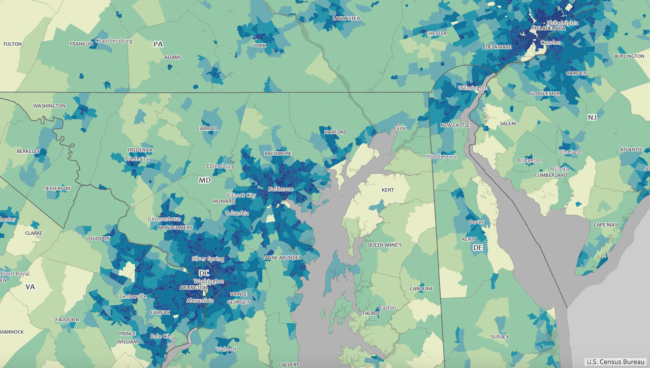
NYC to Philadelphia.


And then Philly to DC.


Here's Miami. I realize Naples, FL is only about a 2-hour drive from Miami. It's funny to me that in this part of the state, it only takes 2 hours to drive from one side of it to the other.


Here's Atlanta. I've never been there, but I guess it's very low-density sprawl?


Here's Austin and Houston. I didn't realize how close they are to each other. People talk about Houston sprawling, but I guess it sprawls differently from LA. At least the way it's portrayed here, it looks compact compared to LA. Like Atlanta, I guess it's more low-density sprawl.


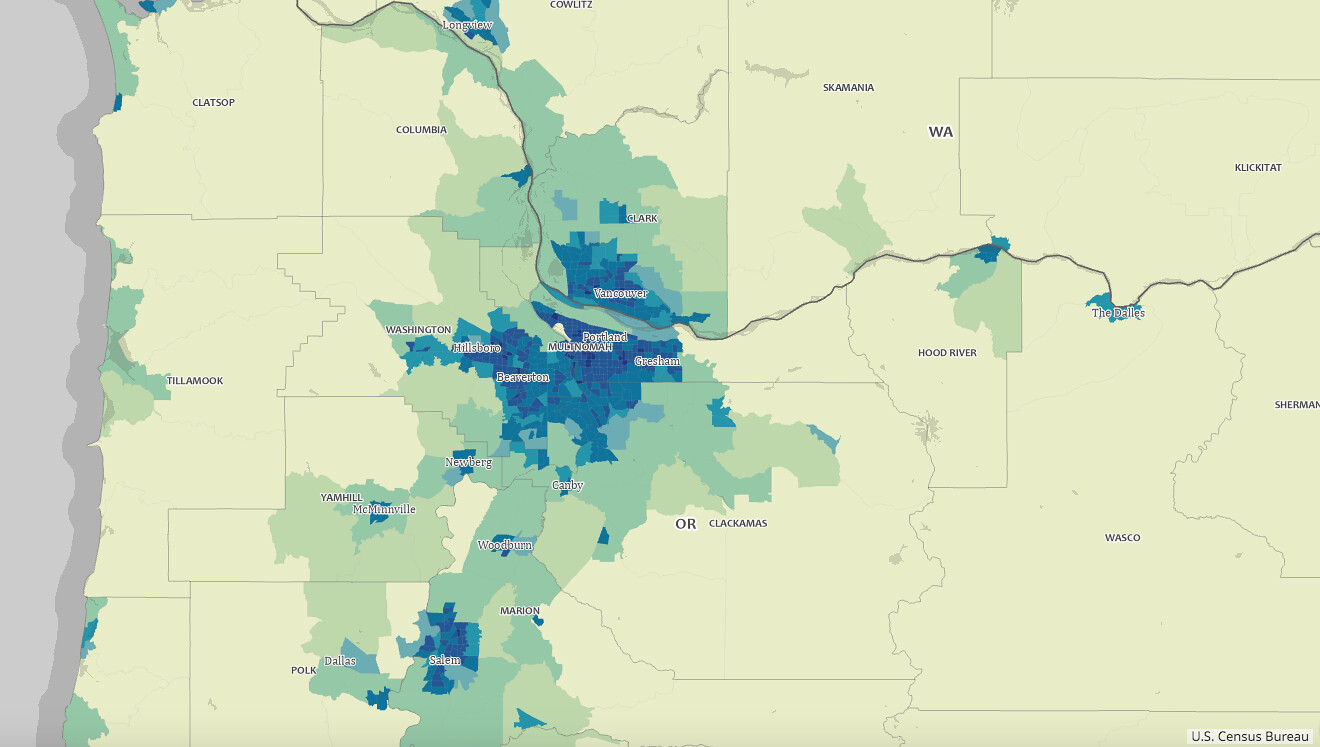
Here's Portland, OR and Salem.


Albuquerque and Santa Fe. Sparse.


Phoenix and Tucson.


Denver and Colorado Springs.


Thought I'd throw in Las Vegas, NV. It looks really small.
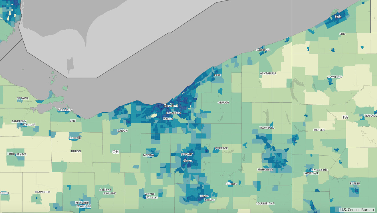

Cleveland.


St. Louis, MO. Is it very rural outside of St. Louis?
__________________
"I guess the only time people think about injustice is when it happens to them."

~ Charles Bukowski
Reply With Quote
     
     
  #87  
Old Posted Jan 31, 2023, 12:16 PM
mousquet's Avatar
mousquet mousquet is offline
Registered User
 
Join Date: Jan 2011
Location: Greater Paris, France
Posts: 4,581
^ Idk how you manage to do that, but it's a good sample of data easy to read.

You may add Seattle, Detroit, some more Ohio, Dallas-Fort Worth, New Orleans and some other significant or well known areas of your country.
But yeah, it is very large and doing this might take some time.

Also, geographers and demographers always say that maps must be annotated with a legend.
They are strict and want everything to be explicit.

But that's a pretty good job that I don't know how to do anyway.
Reply With Quote
     
     
  #88  
Old Posted Jan 31, 2023, 3:26 PM
iheartthed iheartthed is online now
Registered User
 
Join Date: Oct 2009
Location: New York
Posts: 9,895
Quote:
Originally Posted by sopas ej View Post
It's interesting to me, this transition/perceived transition between metros.


Cleveland.
This is Cleveland and about 1/4th of Detroit.
Reply With Quote
     
     
  #89  
Old Posted Jan 31, 2023, 3:43 PM
PhilliesPhan's Avatar
PhilliesPhan PhilliesPhan is offline
Registered User
 
Join Date: Aug 2014
Location: Philadelphia
Posts: 1,265
Quote:
Originally Posted by iheartthed View Post
The Susquehanna River always feels to me like the transition area between Baltimore and Wilmington/Philadelphia from I-95.
100% agree. This is the reason I've long considered Cecil County, MD to be in the Philadelphia MSA/CSA, even if it isn't as culturally aligned with us as, say, New Castle County, DE. Philly's southern transition area is much more apparent than its northern transition area in Mercer County, NJ (one could even make the argument that parts of Hunterdon County and Ocean County--especially Jackson Township--are in this northern transition area).

Quote:
Originally Posted by BigDipper 80 View Post
You definitely see a lot more "hard edges" out west than you do in the midwest and east. In the older metros, the sprawl just gets thinner and thinner before eventually petering out but in California, Arizona and a few other states, it's all pretty much the same density as you move out from the center until it just sort of stops. At least until another developer comes in and builds at the same density again.
I've been flying out to Phoenix a lot more often, as my fiancée is from the Valley. Landing in Phoenix is very interesting, as it comes into view very suddenly. You can be staring at an endless expanse of mountains one minute and the endless sprawl of the Valley the next--an especially striking contrast at night. I've had similar experiences flying into Denver, Los Angeles, Las Vegas, and Reno.
__________________
No one outsmarts a Fox!

Temple University '18 ']['
Reply With Quote
     
     
  #90  
Old Posted Jan 31, 2023, 4:29 PM
dave8721 dave8721 is offline
Registered User
 
Join Date: Jul 2005
Location: Miami
Posts: 4,044
Quote:
Originally Posted by sopas ej View Post
It's interesting to me, this transition/perceived transition between metros.

Being that I'm from the Los Angeles area, I tend to measure things in drive time---and of course in miles, too. Being that I know the scale/distances of Greater LA, I thought I'd do some population 2020 Census density maps to scale in comparison to LA.

Here's Miami. I realize Naples, FL is only about a 2-hour drive from Miami. It's funny to me that in this part of the state, it only takes 2 hours to drive from one side of it to the other.
[img][/img]
With traffic, it is usually quicker to get to Naples than West Palm Beach from Miami on a normal day.
Reply With Quote
     
     
  #91  
Old Posted Jan 31, 2023, 5:43 PM
edale edale is offline
Registered User
 
Join Date: Apr 2017
Posts: 2,225
The large expanses around St. Louis surprise me. I assumed that rural Missouri would be similar to rural Ohio, which is basically all semi-populated as the Cleveland example shows. I know the Illinois side of the STL metro is a very strange, seemingly random low-density development pattern, which is shown pretty clearly on the map. But I didn't realize how truly rural and empty the area around STL is.
Reply With Quote
     
     
  #92  
Old Posted Jan 31, 2023, 6:14 PM
westak westak is offline
Registered User
 
Join Date: Jul 2007
Location: The Rubber City
Posts: 216
Quote:
Originally Posted by edale View Post
The large expanses around St. Louis surprise me. I assumed that rural Missouri would be similar to rural Ohio, which is basically all semi-populated as the Cleveland example shows. I know the Illinois side of the STL metro is a very strange, seemingly random low-density development pattern, which is shown pretty clearly on the map. But I didn't realize how truly rural and empty the area around STL is.
The St. Louis CSA is about the same physical size as NEO which has 5 separate metropolitan areas within it and 3 Micropolitan areas with over 100k each, hence the difference once you get outside of St. Louis and Cleveland.
Reply With Quote
     
     
  #93  
Old Posted Jan 31, 2023, 6:20 PM
Buckeye Native 001 Buckeye Native 001 is offline
E pluribus unum
 
Join Date: Aug 2003
Location: Arizona
Posts: 31,280
Heading west to east, it was pretty well developed from just east of Rolla to the western fringe of St. Louis (low density exurban sprawl), but once you cross into Illinois on 70, its not long before you're driving through farmland.
Reply With Quote
     
     
  #94  
Old Posted Jan 31, 2023, 6:27 PM
edale edale is offline
Registered User
 
Join Date: Apr 2017
Posts: 2,225
Quote:
Originally Posted by westak View Post
The St. Louis CSA is about the same physical size as NEO which has 5 separate metropolitan areas within it and 3 Micropolitan areas with over 100k each, hence the difference once you get outside of St. Louis and Cleveland.
I wasn't comparing St. Louis to Cleveland, but more making an observation about the emptiness of Missouri compared to Midwestern states further east. Looking at a more zoomed out version of the population density maps, Ohio and the southern half of Michigan are basically all shades of green and blue, while Missouri is dominated by yellow. I had thought that Missouri had somewhat similar development patterns as Ohio, with small towns and cities all over the place, but that's not really the case. I think it furthers the case for differentiating between the east and west midwestern states. Great Lakes states vs Great Plains. Missouri seems more aligned with the Great Plains.

https://mtgis-portal.geo.census.gov/...ed2b2fd7ff6eb7
Reply With Quote
     
     
  #95  
Old Posted Jan 31, 2023, 6:52 PM
iheartthed iheartthed is online now
Registered User
 
Join Date: Oct 2009
Location: New York
Posts: 9,895
Quote:
Originally Posted by edale View Post
I wasn't comparing St. Louis to Cleveland, but more making an observation about the emptiness of Missouri compared to Midwestern states further east. Looking at a more zoomed out version of the population density maps, Ohio and the southern half of Michigan are basically all shades of green and blue, while Missouri is dominated by yellow. I had thought that Missouri had somewhat similar development patterns as Ohio, with small towns and cities all over the place, but that's not really the case. I think it furthers the case for differentiating between the east and west midwestern states. Great Lakes states vs Great Plains. Missouri seems more aligned with the Great Plains.

https://mtgis-portal.geo.census.gov/...ed2b2fd7ff6eb7
Lower Michigan and Ohio have gotta be among the most broadly developed regions in the U.S. Especially Ohio, which feels like it has almost no forested areas remaining in the state.
Reply With Quote
     
     
  #96  
Old Posted Jan 31, 2023, 7:02 PM
Steely Dan's Avatar
Steely Dan Steely Dan is online now
devout Pizzatarian
 
Join Date: Jul 2001
Location: Lincoln Square, Chicago
Posts: 29,821
Quote:
Originally Posted by iheartthed View Post
Especially Ohio, which feels like it has almost no forested areas remaining in the state.
what?

there are vast tracts of heavily forested land in SE ohio.

https://www.google.com/maps/@39.5234...!7i8192!8i4096
__________________
"Missing middle" housing can be a great middle ground for many middle class families.
Reply With Quote
     
     
  #97  
Old Posted Jan 31, 2023, 7:07 PM
iheartthed iheartthed is online now
Registered User
 
Join Date: Oct 2009
Location: New York
Posts: 9,895
Quote:
Originally Posted by Steely Dan View Post
what?

there are vast tracts of heavily forested land in SE ohio.

https://www.google.com/maps/@39.5234...!7i8192!8i4096
So one region of the state. It's still a very deforested place, especially compared to its neighbors to the east, southeast and north.
Reply With Quote
     
     
  #98  
Old Posted Jan 31, 2023, 7:20 PM
westak westak is offline
Registered User
 
Join Date: Jul 2007
Location: The Rubber City
Posts: 216
Quote:
Originally Posted by edale View Post
I wasn't comparing St. Louis to Cleveland, but more making an observation about the emptiness of Missouri compared to Midwestern states further east. Looking at a more zoomed out version of the population density maps, Ohio and the southern half of Michigan are basically all shades of green and blue, while Missouri is dominated by yellow. I had thought that Missouri had somewhat similar development patterns as Ohio, with small towns and cities all over the place, but that's not really the case. I think it furthers the case for differentiating between the east and west midwestern states. Great Lakes states vs Great Plains. Missouri seems more aligned with the Great Plains.

https://mtgis-portal.geo.census.gov/...ed2b2fd7ff6eb7
You made a direct comparison concerning the areas "surrounding" St. Louis and Cleveland and being surprised at the large expanse surrounding St. Louis in comparison to Cleveland. You made no mention of other Midwestern States.
Reply With Quote
     
     
  #99  
Old Posted Jan 31, 2023, 7:23 PM
jmecklenborg jmecklenborg is offline
Registered User
 
Join Date: Jul 2003
Posts: 3,166
Quote:
Originally Posted by edale View Post
The large expanses around St. Louis surprise me.
Memphis is similar - almost nothing on the opposite side of the river.
Reply With Quote
     
     
  #100  
Old Posted Jan 31, 2023, 7:28 PM
jmecklenborg jmecklenborg is offline
Registered User
 
Join Date: Jul 2003
Posts: 3,166
Quote:
Originally Posted by iheartthed View Post
So one region of the state. It's still a very deforested place, especially compared to its neighbors to the east, southeast and north.
True, but it also quickly reverts to forest land when fields are abandoned, unlike out west.

The former Jefferson Proving Ground (about 30 miles west of the Ohio line) was typical farmland until 1942. In the subsequent 80 years, it has quickly returned to forest:
https://www.google.com/maps/@38.9282.../data=!3m1!1e3

They're actually managing the forest there now, so they keep doing burns of to create meadows to create a variety of plant and wildlife habitats.
Reply With Quote
     
     
This discussion thread continues

Use the page links to the lower-right to go to the next page for additional posts
 
 
Reply

Go Back   SkyscraperPage Forum > Discussion Forums > City Discussions
Forum Jump


Forum Jump


All times are GMT. The time now is 9:39 PM.

     
SkyscraperPage.com - Archive - Privacy Statement - Top

Powered by vBulletin® Version 3.8.7
Copyright ©2000 - 2024, vBulletin Solutions, Inc.