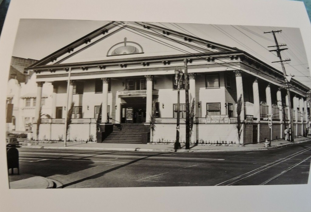
HomeDiagramsDatabaseMapsForum About
     

Go Back   SkyscraperPage Forum > Photography Forums > Found City Photos

Reply

 
Thread Tools Display Modes
     
     
  #59121  
Old Posted Sep 5, 2022, 8:34 PM
Beaudry's Avatar
Beaudry Beaudry is offline
Registered User
 
Join Date: Nov 2009
Posts: 714
Quote:
Originally Posted by odinthor View Post
Thanks for all this great work, FW!

***

Meanwhile, I'm still mousing through the neighborhood to find interesting tidbits. The Hill St. YWCA building was nearby. I ran across this item, which ran as that building was being torn down, and I thought it had certain points of interest . . . it turns out the YWCA was in the Conservative Life Bldg. for a time:


LA Times, 7/4/1971
Here's something I wrote about the YWCA back in the day. At the time I didn't know it was designed by Arthur B. Benton, who is perhaps best known for yet another YWCA.


The Hotel Belmont creeps up in Bunker Noir!, of course—

Reply With Quote
     
     
  #59122  
Old Posted Sep 5, 2022, 8:56 PM
Beaudry's Avatar
Beaudry Beaudry is offline
Registered User
 
Join Date: Nov 2009
Posts: 714
Quote:
Originally Posted by Ossrae View Post
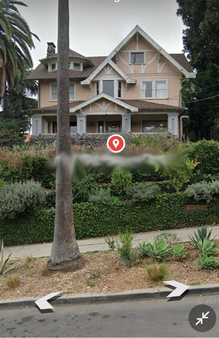
I'm researching aspects of this historic NELA house but am having trouble identifying the style. The expert I asked thinks it could be contemporary to Victorian but a different style than Victorian.

Thank you.


Source: https://www.google.com/maps/place/13...4d-118.2791789
Great house. As you probably know, it was designed by Frank M. Tyler for CH and Ella Howard. Interestingly, they held the funeral for their 15-yo son Harold there in February 1909.

It has elements of some Victorian residential structures but it would be misleading to apply the term. Especially since the house was built in the summer of 1907. That makes it strictly speaking an Edwardian house.

As to "style" I'd venture to say it's a "Tudor-Craftsman." The multiple front-facing gables plant it in the Craftsman vernacular, as does the large open porch (and I love the use of clinker brick instead of the usual river rock). Then, there's decorative half-timbering on the upper stucco portions, that's Tudor.

Were it my house, I'd paint the board dark brown and the stucco cream.

The "maltese cross" design on the door is seriously one of the best residential doors I've seen anywhere, anytime.
Reply With Quote
     
     
  #59123  
Old Posted Sep 5, 2022, 9:54 PM
HossC's Avatar
HossC HossC is offline
Registered User
 
Join Date: Aug 2013
Posts: 4,245
Quote:
Originally Posted by Beaudry View Post

232 is proving to be a bit elusive. I figured it would show in one of those shots from Angels Flight but I haven't found it. This is as close as I've come, just a sliver of its north side on Hill—


lapl
Here's a slightly better view of 232 S Hill Street. It's just to the right of the "CHIROPRACTIC" blade sign. This is a detail from a 1939 Dick Whittington photo.


USC Digital Library
Reply With Quote
     
     
  #59124  
Old Posted Sep 6, 2022, 12:49 AM
rick m rick m is offline
Registered User
 
Join Date: Sep 2011
Posts: 225
Awesome Beaudry-- This I will put (eventually) into folder at One Archives-for Mattachine Society /L.A.
Reply With Quote
     
     
  #59125  
Old Posted Sep 6, 2022, 5:34 PM
Ossrae Ossrae is offline
Registered User
 
Join Date: Aug 2022
Posts: 14
Thank you!! That's an amazing picture!

Quote:
Originally Posted by Bristolian View Post
This closeup from a 1928 UCSB Framefinder aerial seems to confirm the White Point location. The rectangular basin and the rock outcropping in the distance seem to be a match.

https://mil.library.ucsb.edu/ap_imag...c-300_m-64.tif
Reply With Quote
     
     
  #59126  
Old Posted Sep 6, 2022, 8:05 PM
Bristolian's Avatar
Bristolian Bristolian is offline
Registered User
 
Join Date: Jul 2015
Location: The Outskirts
Posts: 415


Happy to help. I posted in 2018 about a long lost golf course above the beach there. My previous post
The area must have seemed like the end of the world back then.
Reply With Quote
     
     
  #59127  
Old Posted Sep 7, 2022, 3:48 AM
MartinTurnbull's Avatar
MartinTurnbull MartinTurnbull is offline
Registered User
 
Join Date: Oct 2011
Location: Los Angeles
Posts: 223
The Tower of Mystery

I've spent the past few days trying to ID the tower in the background of these two circa early 1940s photos without much luck. So I'm hoping the hive mind might be able to come up with the answer.

The photos have been identified as looking west along Beverly Blvd. The traffic lights in the foreground are on Robertson Blvd. Assuming the above is true, which I'm pretty sure it is, I'm thinking that puts the tower in the background that I'm trying to identify at around La Peer or Almont.

It looks to me like it's one of those ornamental towers that they loved to stick on top of gas stations and the like in the 1930s. If anybody recognizes it, I'd LOVE to hear from you.

Thanks, guys!


https://pastvu.com/p/469496

Reply With Quote
     
     
  #59128  
Old Posted Sep 7, 2022, 6:10 PM
HossC's Avatar
HossC HossC is offline
Registered User
 
Join Date: Aug 2013
Posts: 4,245


My first thought was Carthay Circle, but I was wrong. It's the Beverly Tower at the intersection of Beverly and San Vicente Boulevards, which means that the shot above is Beverly Boulevard looking east at Robertson Boulevard.

The description says: View of a section of San Vicente Boulevard, showing some Art Deco buildings. In the background is the Beverly Tower, which is a service station, next to that, in the center of the image, is a little eatery. A painted wooden sign on the left advertises horseback riding lessons.


LAPL
Reply With Quote
     
     
  #59129  
Old Posted Sep 7, 2022, 6:30 PM
MartinTurnbull's Avatar
MartinTurnbull MartinTurnbull is offline
Registered User
 
Join Date: Oct 2011
Location: Los Angeles
Posts: 223
Ah! Thanks, HossC! So my inkling that it was an ornamental gas station tower was right on the money, after all. Thanks much!


Quote:
Originally Posted by HossC View Post


My first thought was Carthay Circle, but I was wrong. It's the Beverly Tower at the intersection of Beverly and San Vicente Boulevards, which means that the shot above is Beverly Boulevard looking east at Robertson Boulevard.

The description says: View of a section of San Vicente Boulevard, showing some Art Deco buildings. In the background is the Beverly Tower, which is a service station, next to that, in the center of the image, is a little eatery. A painted wooden sign on the left advertises horseback riding lessons.


LAPL
Reply With Quote
     
     
  #59130  
Old Posted Sep 7, 2022, 7:16 PM
Martin Pal Martin Pal is offline
Registered User
 
Join Date: Sep 2013
Posts: 2,452
Great find for that photo, HossC. Though something is confusing me.
Let me ponder it.

Last edited by Martin Pal; Sep 7, 2022 at 8:03 PM.
Reply With Quote
     
     
  #59131  
Old Posted Sep 7, 2022, 7:48 PM
Martin Pal Martin Pal is offline
Registered User
 
Join Date: Sep 2013
Posts: 2,452
HossC, I am somewhat confused.

https://pastvu.com/p/469496

This above link lists the two similar photos were taken at Beverly Blvd. and Bonner Dr., one on March 5, 1941, and the other on June 5, 1941 (hence the two different billboards).

The map on the page indicates Bonner Dr. t-bones Beverly Blvd. from the north and is in between Robertson and San Vicente. The photo you posted (c. 1940) indicates the caption saying: "View of a section of San Vicente Boulevard" and your conclusion is that the other two photos are: "the shot/s above is Beverly Boulevard looking east at Robertson Boulevard."

If one is looking east on Beverly from Bonner, Robertson is west, the other direction. The map included on the link page seems to indicate this gas station would be on Robertson and the photo looking west toward Robertson. The LAPL indication of the businesses being on San Vicente would be incorrect in this case. Something doesn't seem accurate to me. Or, I could just confused? (It's hot here! )

Last edited by Martin Pal; Sep 7, 2022 at 8:02 PM.
Reply With Quote
     
     
  #59132  
Old Posted Sep 7, 2022, 8:42 PM
HossC's Avatar
HossC HossC is offline
Registered User
 
Join Date: Aug 2013
Posts: 4,245


Here's a 1937 aerial of the area. You'll see that Bonner Drive originally went straight to the intersection of Beverly and Robertson. Looking at Historic Aerials, the layout was still similar in the late '40s. In my head, the 1940s photos were taken from the left of this aerial looking to the right (east). I've labeled what I think is Beverly Tower. My assumption is reinforced by the writing on the roof below it reading "L.A. RIDING ACADEMY", tying in with the "HORSEBACK RIDING LESSONS" sign on the left of my earlier photo.


mil.library.ucsb.edu
Reply With Quote
     
     
  #59133  
Old Posted Sep 8, 2022, 12:10 AM
Martin Pal Martin Pal is offline
Registered User
 
Join Date: Sep 2013
Posts: 2,452
.
That aerial explains it, HossC! Thank you. The current Bonner Drive curves down to Beverly Blvd. approximately where the second "n" in Bonner is written on the 1937 aerial. So what you said makes sense now!

Click on the photo in the quoted post below if you want a larger version.

Quote:
Originally Posted by Martin Pal View Post
A 1930's aerial of West Hollywood:
[...]


Link HERE. (Playground to the Stars)
_________________________________________________________________
I had posted this above aerial that was identified as a 1930's aerial. When I looked at the link again today, the website's moderator, Jon Ponder, had updated it:

Correction: Additional research found that the Los Angeles Riding Academy (in the foreground) was sold in 1924, so obviously the photo was taken before then. I updated the headline to reflect the date change. – Jon, Sept. 11, 2020.

In the 1937 aerial the Riding Academy does look different in a lot of ways. He doesn't say if the Academy was still being used for any other horse related activities, but it would makes sense that it was from the riding lessons sign in the 1937 aerial.
Reply With Quote
     
     
  #59134  
Old Posted Sep 8, 2022, 4:20 AM
ethereal_reality's Avatar
ethereal_reality ethereal_reality is offline
Registered User
 
Join Date: Feb 2008
Location: Lafayette/West Lafayette IN, Purdue U.
Posts: 16,350
.
Mystery buildings.


"Vintage 1938 Snapshot Photo Woman Buried in Sand on Beach Los Angeles CA " (half buried, if that) unless there's another girl under the sand.


Currently on eBay


Let's take a closer look at those buildings in the background.


hmm. . .Venice Beach?

I'd say the building on the left is a hotel and the building on the right is. .um. .well, that looks like a box office in the arched entrance but it doesn't look like a theater. (and is that a barber pole to the right of the entrance?)

.

Last edited by ethereal_reality; Sep 8, 2022 at 4:33 AM.
Reply With Quote
     
     
  #59135  
Old Posted Sep 8, 2022, 4:28 AM
ethereal_reality's Avatar
ethereal_reality ethereal_reality is offline
Registered User
 
Join Date: Feb 2008
Location: Lafayette/West Lafayette IN, Purdue U.
Posts: 16,350
.
. . .and since we're down the beach.


A one of a kind snapshot of Venice, the Hotel St. Regis and Ocean Park Pier. (1940s?)


Currently on eBay

....................................................................I spy three sailors.


.
Reply With Quote
     
     
  #59136  
Old Posted Sep 8, 2022, 11:25 AM
Noir_Noir Noir_Noir is offline
Registered User
 
Join Date: Feb 2018
Posts: 482
Quote:
Originally Posted by ethereal_reality View Post
.
Mystery buildings.

"Vintage 1938 Snapshot Photo Woman Buried in Sand on Beach Los Angeles CA "


Just in terms of the date of the picture - it's likely from 1941 and not 1938 as the ebay seller has it.

As the seller points out the posters in the background are for Ringling Bros. Circus in Long Beach on Sept. 17.

The only years the circus was in Long Beach on that date were 1923 and 1941. The cars in the picture indicate the later year.


classic.circushistory.org
Reply With Quote
     
     
  #59137  
Old Posted Sep 8, 2022, 5:38 PM
ethereal_reality's Avatar
ethereal_reality ethereal_reality is offline
Registered User
 
Join Date: Feb 2008
Location: Lafayette/West Lafayette IN, Purdue U.
Posts: 16,350
.
Thanks for the correction, Noir Noir. I spent a good portion of an hour trying to read the posters not realizing
the seller mentioned Ringling Bros. Circus.


.
Reply With Quote
     
     
  #59138  
Old Posted Sep 8, 2022, 6:32 PM
ethereal_reality's Avatar
ethereal_reality ethereal_reality is offline
Registered User
 
Join Date: Feb 2008
Location: Lafayette/West Lafayette IN, Purdue U.
Posts: 16,350
.
1946 Mystery


I don't recall seeing this fantastic building on NLA. (but as many of you know, my memory stinks)... I searched the thread using "bosley" and received no hits.

Seller's description:..1946 Goldberg-Bosley Dance Ballroom Venice Blvd & S. Flower St Los Angeles Photo.


Currently on eBay


The reverse.


I found the ballroom(?) in the 1916 city directories with a slight variation between 1601 and 1606 S. Flower Street.


1916 LAPL


1929 LAPL


Oh, I almost forgot. Here's a closer look at the signs at the southeast? corner of S. Flower and Venice Blvd..


detail

OK, folks. Let's find a photograph of the interior! . .and, if luck is with us, perhaps a photograph of Philip & Ida tripping the light fantastic.


Go minions! hahahhahah (evil laugh)
.
Reply With Quote
     
     
  #59139  
Old Posted Sep 8, 2022, 6:59 PM
HossC's Avatar
HossC HossC is offline
Registered User
 
Join Date: Aug 2013
Posts: 4,245


It looks like we got a small look at Goldberg-Bosley Dance Ballroom nearly 10 years ago. In your original post, e_r, you posted a detail view from the image below, but it's now missing. GW replied to this detail with a couple of LAT articles including one about a fire bomb.

I found a matchbook cover at www.flickr.com which describes the ballroom as the "Best Ventilated in Los Angeles".

Quote:
Originally Posted by ethereal_reality View Post

Los Angeles, in that infamous year 1947.


ebay

Can anyone tell me where this photograph was taken? (I just noticed the slight 'jog' in the street)
Quote:
Originally Posted by GaylordWilshire View Post

Looks like this was originally the Goldberg-Bosley Hall...

Los Angeles Times, Nov 13, 1908

Los Angeles Times, Jan 28, 1922

Sixteenth is now Venice Blvd; there are Times references to it up to the mid-'30s...
Reply With Quote
     
     
  #59140  
Old Posted Sep 8, 2022, 7:13 PM
Martin Pal Martin Pal is offline
Registered User
 
Join Date: Sep 2013
Posts: 2,452
Both the L.A. Metro Line A (Blue) and E Line (Expo) both run down Flower St. now, past where this ballroom was located.
Reply With Quote
     
     
This discussion thread continues

Use the page links to the lower-right to go to the next page for additional posts

Reply

Go Back   SkyscraperPage Forum > Photography Forums > Found City Photos
Forum Jump


Forum Jump


All times are GMT. The time now is 10:44 AM.

     
SkyscraperPage.com - Archive - Privacy Statement - Top

Powered by vBulletin® Version 3.8.7
Copyright ©2000 - 2024, vBulletin Solutions, Inc.