HomeDiagramsDatabaseMapsForum About
     

Go Back   SkyscraperPage Forum > Global Projects & Construction > General Development


Reply

 
Thread Tools Display Modes
     
     
  #141  
Old Posted Mar 3, 2024, 3:57 AM
TouchTheSky13 TouchTheSky13 is offline
Registered User
 
Join Date: Nov 2011
Location: Washington, D.C.
Posts: 266
Trenton closer to long-sought freeway removal


The big move in the plan was to transform Route 29, located between the Delaware River and the city, into a riverfront drive. That idea would open up many blocks for redevelopment with a typological code (a forerunner of today’s form-based codes). The plan was not implemented, but transforming Route 29 from a highway to a surface street never entirely went away. The state DOT authored plans for converting the highway in 2005, 2009, and 2017—and now the concept is moving to the forefront again.

The boulevard could have a remarkable impact on improving quality of life. Residents who seek to reach the river to fish, for example, are forced to endanger their lives by illegally crossing the highway, the submission states. This project would open whole new recreational parklands. A 2009 study estimated the cost of the project at $140 million.

A report on cnu.org estimates that “The Waterfront Reclamation project could contribute $2.25 billion to the city’s economy while improving access to the river, bicycle and pedestrian connections, vehicular circulation, and traffic safety.”

https://www.cnu.org/publicsquare/202...ighway-removal
__________________
"They told me that I had the right to remain silent, but I didn't have the ability."
Reply With Quote
     
     
  #142  
Old Posted Mar 3, 2024, 4:00 AM
TouchTheSky13 TouchTheSky13 is offline
Registered User
 
Join Date: Nov 2011
Location: Washington, D.C.
Posts: 266
Albany's bold campaign for highway removal


Re-Envision Albany is a conceptual illustration of the city without I-787, a 10-mile section of Interstate serving commuters to the state office complex (through traffic uses I-87 north and south and I-90 east and west, both of which go through the city). Since the goal is to inspire discussion by showing what is possible, the plan is flexible to allow for organic growth, the group emphasizes.

The group studied historic maps and analyzed existing conditions to determine the best way to repair the damage and move forward. “It became clear that the best solution was to re-imagine I-787 as a surface boulevard connecting to a network of streets,” the collaborative told CNU. “This would establish an urban street network similar to what had existed before while bringing enhancements to the historic infrastructure. Streets are designed to include multi-modal infrastructure that could be extended into other areas of the city. Reviving the street network enables the urban fabric to develop by proposing new parks along with over six million square feet of development for a wide range of new residences, offices, civic uses, and commercial spaces. Economic impacts of the design were studied and shown to bring more opportunity in the form of over $300 million in financial benefits to the city, along with over 3,000 new jobs.”
__________________
"They told me that I had the right to remain silent, but I didn't have the ability."
Reply With Quote
     
     
  #143  
Old Posted Mar 3, 2024, 4:10 AM
TouchTheSky13 TouchTheSky13 is offline
Registered User
 
Join Date: Nov 2011
Location: Washington, D.C.
Posts: 266
Akron releases report, recommendations on next steps for decommissioned Innerbelt

Gotta say, it seems like Akron is dragging its feet and settling for an uninspired plan for the Innerbelt. They need to go bigger and go with a full teardown and boulevard conversion or at least a phased approach that will ultimately accomplish that. This does not do that.


The city plans to lead further community engagement on the report in the coming weeks. In 2024, the city will open the request for qualifications process to engage a master planning team. The master plan will be funded by a federal Reconnecting Communities and Neighborhoods grant from the United States Department of Transportation and will focus on how to transform the 1-mile section of the Innerbelt.

https://www.ideastream.org/governmen...oned-innerbelt
__________________
"They told me that I had the right to remain silent, but I didn't have the ability."

Last edited by TouchTheSky13; Mar 13, 2024 at 8:34 PM.
Reply With Quote
     
     
  #144  
Old Posted Mar 3, 2024, 4:18 AM
TouchTheSky13 TouchTheSky13 is offline
Registered User
 
Join Date: Nov 2011
Location: Washington, D.C.
Posts: 266
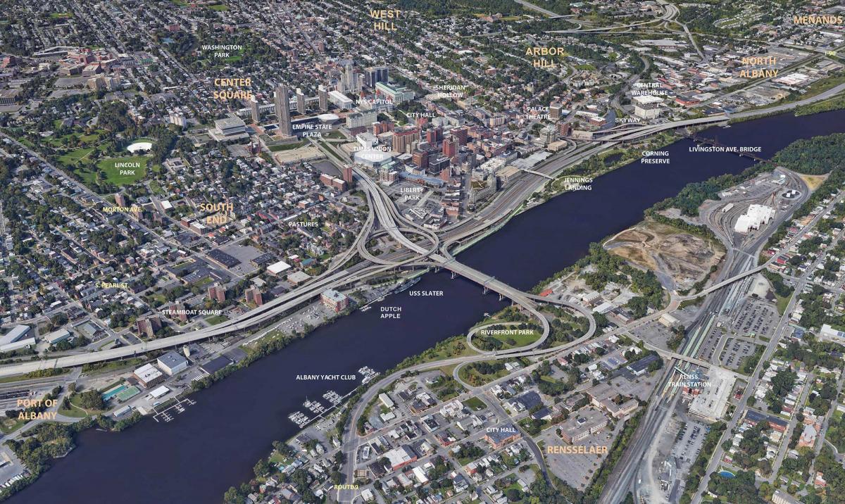
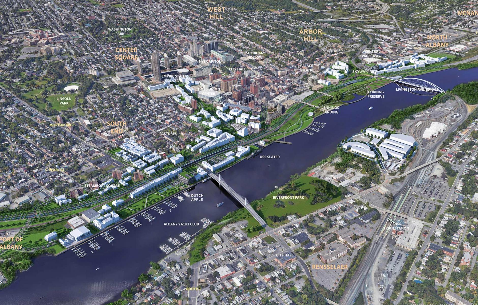
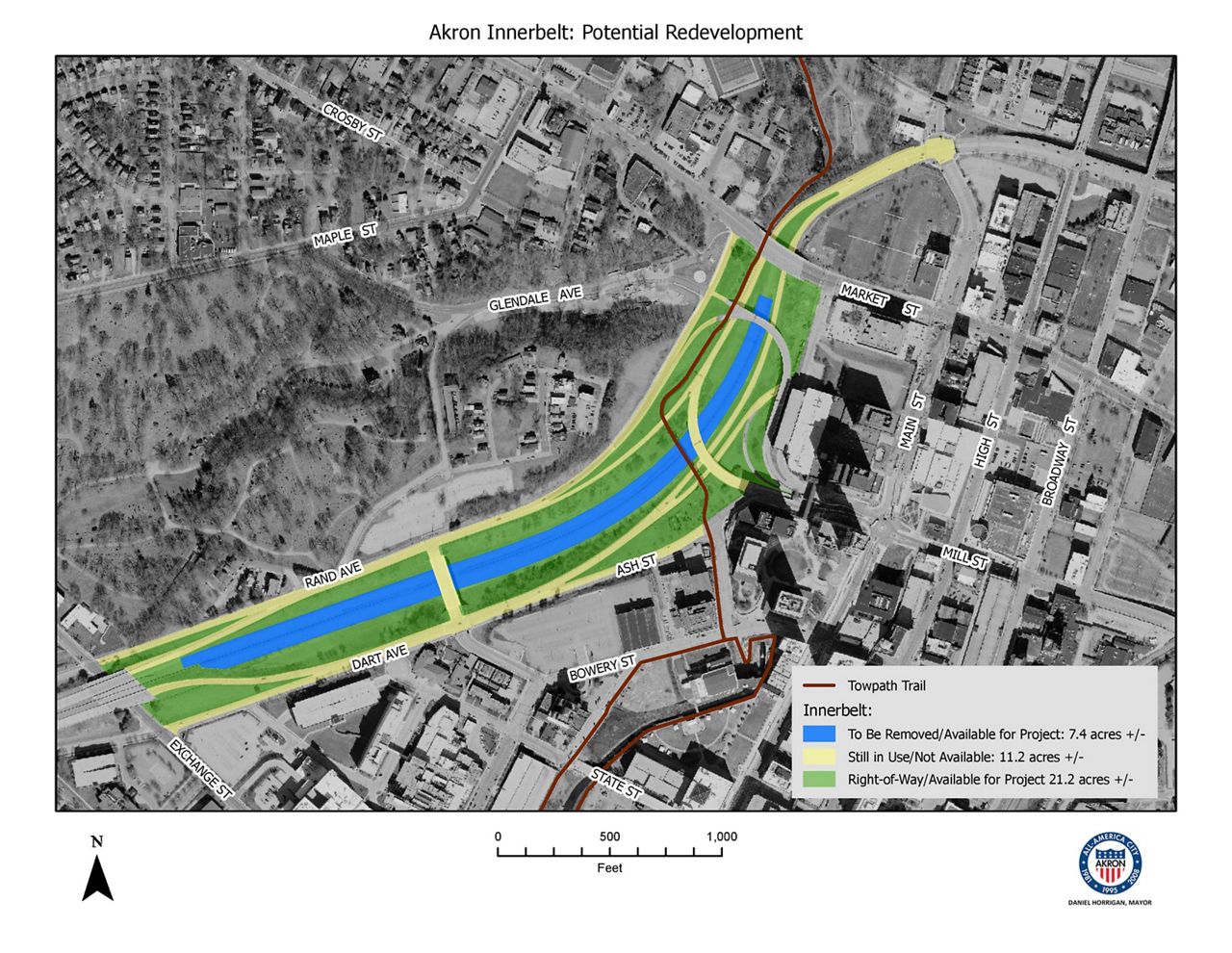
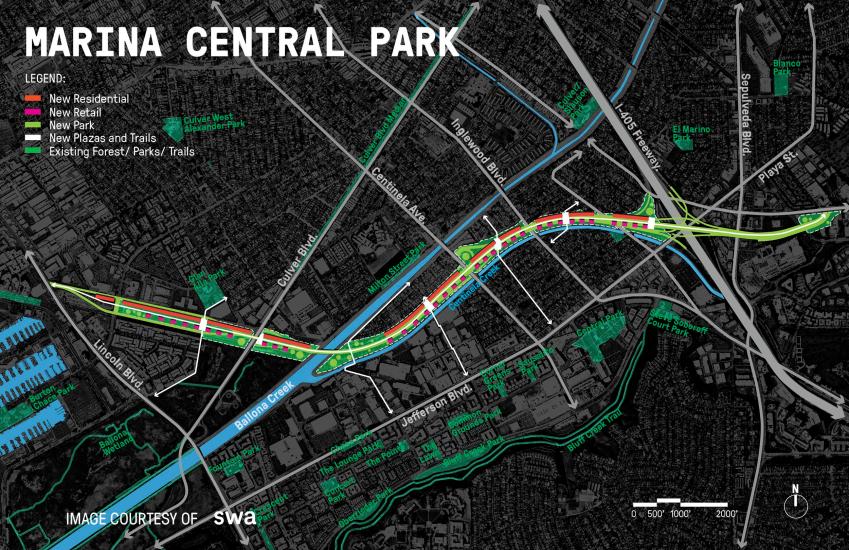
Manhattan BP Wants To Raze FDR Drive South of Brooklyn Bridge


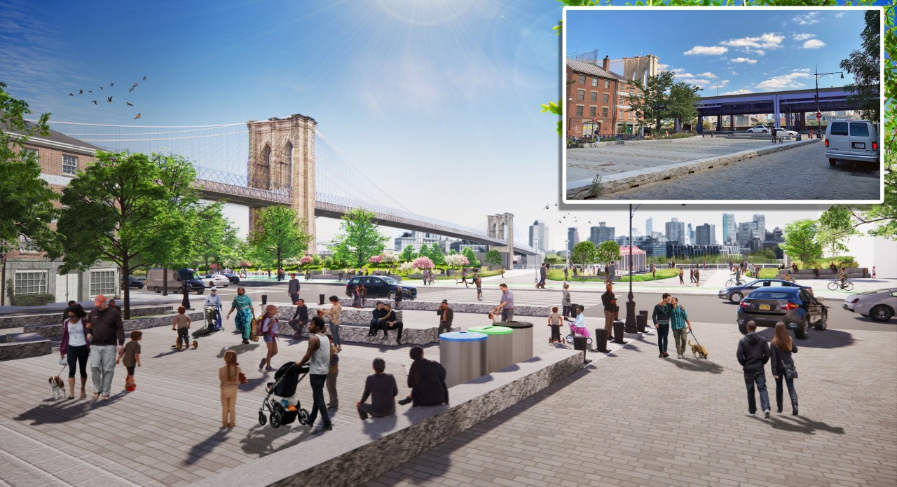
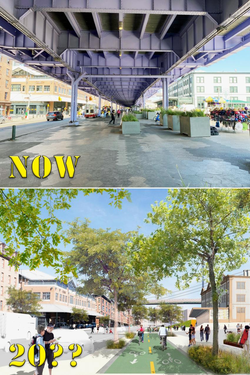
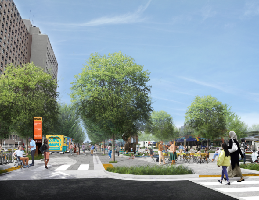
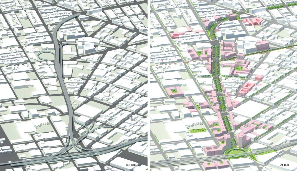
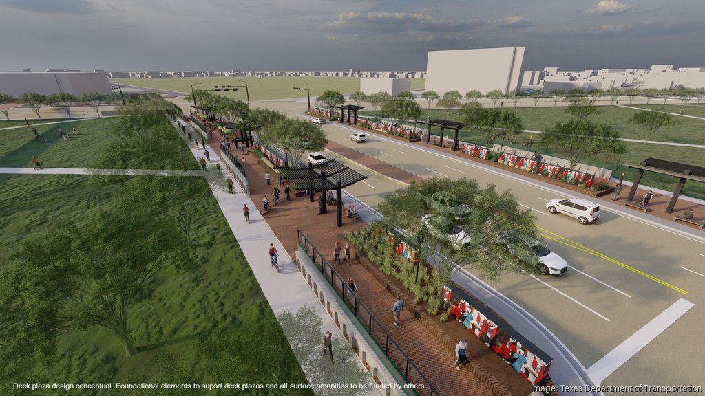
A newly revived dream of tearing down the FDR viaduct south of the Brooklyn Bridge and turning it into a waterfront bike and pedestrian oasis must overcome state and federal bureaucrats who have often been unwilling to remove awful urban highways.

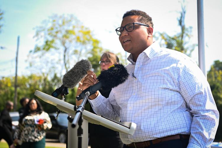
Borough President Mark Levine said on Wednesday that he hopes to get federal support for the ambitious plan to remove the underused section of elevated highway between the bridge and the Battery Park underpass, but realizes that he faces a long road to, well, tear down a road.

“There’ll be many legal, environmental, obviously financial, jurisdictional questions that we’ll have to work through, but ... we’re confident that if we can get the infusion of resources from U.S. DOT, we’ll be off and running,” Levine told reporters at a press conference at the Seaport.

The beep wants Mayor Adams to apply for a federal Reconnecting Communities and Neighborhoods grant before the Sept. 28 deadline. The Biden bucks previously funded a $2-million study of capping the Cross-Bronx Expressway.

https://nyc.streetsblog.org/2023/09/...rooklyn-bridge
__________________
"They told me that I had the right to remain silent, but I didn't have the ability."
Reply With Quote
     
     
  #145  
Old Posted Mar 3, 2024, 4:24 AM
TouchTheSky13 TouchTheSky13 is offline
Registered User
 
Join Date: Nov 2011
Location: Washington, D.C.
Posts: 266
Mayor Bass Reverses Stance on Marina 90 Freeway Removal

Booooo!!!!

True to form for NIMBY-indulging Los Angeles, the political support he believed was solid has suddenly turned porous.

That includes Bass: “I do not support the removal or demolition of the 90 Freeway,” she said in a statement last week. “I’ve heard loud and clear from communities who would be impacted and I do not support a study on this initiative.”

L.A. City Councilmember Traci Park agrees with her. After conducting a very unscientific poll of her Westside constituents, she wrote in her newsletter that: “The 11th District does not support the demolition of the 90 Freeway. Your voice is why Mayor Bass rescinded her initial support.”


https://youtu.be/pOO1j5eqqeo
__________________
"They told me that I had the right to remain silent, but I didn't have the ability."
Reply With Quote
     
     
  #146  
Old Posted Mar 3, 2024, 4:39 AM
TouchTheSky13 TouchTheSky13 is offline
Registered User
 
Join Date: Nov 2011
Location: Washington, D.C.
Posts: 266
Governor Hochul Announces Advancement of Historic Kensington Expressway Project to Reconnect East Buffalo Communities


https://www.governor.ny.gov/news/gov...reconnect-east
__________________
"They told me that I had the right to remain silent, but I didn't have the ability."
Reply With Quote
     
     
  #147  
Old Posted Mar 3, 2024, 4:50 AM
TouchTheSky13 TouchTheSky13 is offline
Registered User
 
Join Date: Nov 2011
Location: Washington, D.C.
Posts: 266
Split by I-37, San Antonio seeks federal funds to reconnect East Side to downtown

Hate to break it to San Antonians, but they're not getting this money. Too much competition. Swing states will be prioritized, because of course they will. This would be huge for the city though.


https://sanantonioreport.org/east-si...hoods-program/
__________________
"They told me that I had the right to remain silent, but I didn't have the ability."
Reply With Quote
     
     
  #148  
Old Posted Mar 3, 2024, 4:53 AM
TouchTheSky13 TouchTheSky13 is offline
Registered User
 
Join Date: Nov 2011
Location: Washington, D.C.
Posts: 266
Broken Arrow awarded federal infrastructure grant to reconnect communities


The City of Broken Arrow received $5.8 million dollars from the federal government for infrastructure improvements. The award comes from the Rebuilding American Infrastructure with Sustainability and Equity Grant Program through the U.S. Department of Transportation.

The City seeks to reconnect communities separated by the Broken Arrow Expressway.

Plans for increased connectivity outlined in Broken Arrow’s grant application include improvements to the Elm Place and 9th Street corridors and trail and sidewalk upgrades along the Kenosha Street corridor.

https://www.kosu.org/local-news/2023...ct-communities
__________________
"They told me that I had the right to remain silent, but I didn't have the ability."
Reply With Quote
     
     
  #149  
Old Posted Mar 3, 2024, 5:02 AM
TouchTheSky13 TouchTheSky13 is offline
Registered User
 
Join Date: Nov 2011
Location: Washington, D.C.
Posts: 266
MassDOT’s Allston I-90 Plans Suffer Another Rejection for Federal Funding


Quote:
Last summer, MassDOT submitted its second application to finance the project through the U.S. Department of Transportation's (USDOT) Multimodal Project Discretionary Program, a trio of multi-billion-dollar competitive grant programs that were created or expanded in the 2021 infrastructure law.

These grant programs aim to help states finance unusually large and complex projects, but they are also extremely competitive.

In its first attempt for this funding, in 2021, MassDOT requested $1.2 billion for the Allston I-90 project through the federal National Infrastructure Project Assistance Program (popularly known as the "Mega" grant program).

Washington rejected that application, along with hundreds of others from other states, and instead awarded $1.2 billion to 9 different projects, none of which were in Massachusetts.

MassDOT submitted a more modest request for the Allston project last summer, asking the feds for $200 million (about 1/10th of the project's 2021 cost estimate).

Last month, the USDOT announced awards for 11 projects for 2024.

MassDOT won $372 million in federal funding to rebuild the Sagamore Bridge to Cape Cod – but nothing for the Allston project.
__________________
"They told me that I had the right to remain silent, but I didn't have the ability."
Reply With Quote
     
     
  #150  
Old Posted Mar 3, 2024, 2:57 PM
Busy Bee's Avatar
Busy Bee Busy Bee is offline
Show me the blueprints
 
Join Date: Feb 2006
Location: on the artistic spectrum
Posts: 10,376
News Blast
__________________
Everything new is old again

There is no goodness in him, and his power to convince people otherwise is beyond understanding
Reply With Quote
     
     
  #151  
Old Posted Mar 3, 2024, 3:25 PM
ardecila's Avatar
ardecila ardecila is offline
TL;DR
 
Join Date: Jun 2006
Location: the city o'wind
Posts: 16,384
Quote:
Originally Posted by TouchTheSky13 View Post
Broken Arrow awarded federal infrastructure grant to reconnect communities

The City of Broken Arrow received $5.8 million dollars from the federal government for infrastructure improvements. The award comes from the Rebuilding American Infrastructure with Sustainability and Equity Grant Program through the U.S. Department of Transportation.

The City seeks to reconnect communities separated by the Broken Arrow Expressway.

Plans for increased connectivity outlined in Broken Arrow’s grant application include improvements to the Elm Place and 9th Street corridors and trail and sidewalk upgrades along the Kenosha Street corridor.

https://www.kosu.org/local-news/2023...ct-communities
This confused me at first... FHWA does have a "Reconnecting Communities" grant that is intended for urban communities that were torn up by freeways, especially low income ones. This project is neither urban, nor low-income - it's just a typical sprawlburg.

But the money here came from the RAISE program, not Reconnecting Communities. RAISE is just a general slush fund program to pay for miscellaneous stuff. I would certainly object to taking money set aside for urban communities and sending it to the suburbs, but I guess this is OK if it's a different pot of money. These sprawly places often have little or no pedestrian infrastructure, and they do need *something*.
__________________
la forme d'une ville change plus vite, hélas! que le coeur d'un mortel...
Reply With Quote
     
     
  #152  
Old Posted Mar 4, 2024, 4:26 AM
TouchTheSky13 TouchTheSky13 is offline
Registered User
 
Join Date: Nov 2011
Location: Washington, D.C.
Posts: 266
In 2011, a stretch of Interstate 195 through Providence was relocated, freeing 26 acres of land for redevelopment, and creating 7 acres of open space along the city's waterfront. The move was genius. Here's an update on how that land has been redeveloped and the eight remaining undeveloped parcels.

What’s the latest in the I-195 Redevelopment District?


Quote:
Four proposals for Parcel 1A were heard at the Commission’s Nov. 15 meeting, including one from The Providence Flea, which currently leases the space to operate its market on Sundays. At the meeting, Commission Chairman Marc Crisafulli said that Providence Flea will have space to continue operating regardless of which proposal is chosen.

According to I-195 District guidelines, proposals will require a waiver from the 25-foot Urban Coastal Greenway construction setback, alignment with the College Hill National Register Historic District and a commemoration of the former Coin, Patriot and Doubloon streets as well as unnamed riverfront gangways. No parking lots or garages will be permitted in the parcel.

Developers submitting proposals for Parcel 5, which also falls within the College Hill National Register Historic District, are encouraged by District guidelines to account for the area’s foot and bicycle traffic in their designs.

In 2018, three developers proposed projects that included Parcel 5. Post Road Residential proposed a luxury apartment building and retail space for Parcel 5 only, while Spencer Providence LLC proposed a combination of housing, retail, restaurants, a hotel and a grocery store across Parcels 2 and 5. Crown Holdings — a team under the Carpionato Group — proposed a wet lab, medical office space, upscale hotel, apartments, restaurants and a grocery space for Parcels 2, 5 and 6, which the Commission later deemed unviable.

Residential uses are not permitted on Parcel 27 and I-195 District guidelines recommend that proposals prioritize active ground floor uses, especially along Clifford Street.

Parcels 34, 35, 37 and 41 are four of the five parcels in the West Side Highway District, which allows the greatest density and aims to promote both pedestrian activity and commercial and economic development. Specific recommendations from I-195 District guidelines include the prioritization of active ground floor uses and designs that engage pedestrian activity, such as through landscaping and “pocket parks.”

All four parcels have minimum building heights of six stories and maximum heights of 345 feet. During the final phase of construction at South Street Landing, Parcel 34 was temporarily leased as a staging site and has since remained open for proposals.

On Parcel 42, a three-skyscraper project was proposed in 2016 by the Fane Organization and approved in 2019. Due to increased costs, the original design could not be built and a new design was presented to the Commission in January 2023. Following design concerns from Utile, a consultant for the Commission, the group presented design updates in February.

But in March, the Fane Organization announced that the proposed luxury building would not be constructed, citing “recent risk factors” outside the developer’s control. The parcel remains open for proposals.


https://www.browndailyherald.com/art...pment-district
__________________
"They told me that I had the right to remain silent, but I didn't have the ability."
Reply With Quote
     
     
  #153  
Old Posted Mar 6, 2024, 10:11 PM
TouchTheSky13 TouchTheSky13 is offline
Registered User
 
Join Date: Nov 2011
Location: Washington, D.C.
Posts: 266
Twin Cities Advocates Split Over What’s Possible for Their Downtown Highway

Do itttttt. Come on, Twin Cities! Land Bridges are way more expensive both in the short term and the long term. A multimodal boulevard makes so much more sense.


Quote:
A proposal to tear down a Minnesota highway that's devastated Black and low-income communities for generations is officially back on the table — and fueling a heated debate among advocates about whether it's actually possible.

In mid-July, the Minnesota Department of Transportation rolled out a slate of 10 design alternatives for the future of a 7.5-mile stretch of Interstate 94 that runs between Minneapolis and St. Paul, including two options that would bring the highway to grade and convert it into a boulevard, which won the most community support in early public meetings.

That came as a pleasant surprise to some local advocates, many of whom have been told for years that Minnesota's most-used freeway was an unlikely candidate for a full-scale teardown. For local non-profit Our Streets Minneapolis, though, thoroughly reimagining I-94 isn't just the best option on the table — it's the only option if the Land of 10,000 Lakes truly wants to reckon with the racist legacy of its transportation choices.

"I would argue that it isn't bold at all to think about affording these communities the same quality of life that has been afforded to white Americans for generations," said José Antonio Zayas Cabán, the group's executive director. "It's really more just about catching up to historic racial inequities and intentional racial targeting, as well as the disruption of opportunity for black Americans to generate wealth across generations."


__________________
"They told me that I had the right to remain silent, but I didn't have the ability."
Reply With Quote
     
     
  #154  
Old Posted Mar 6, 2024, 10:17 PM
TouchTheSky13 TouchTheSky13 is offline
Registered User
 
Join Date: Nov 2011
Location: Washington, D.C.
Posts: 266
Should Capital Boulevard become a 6-lane freeway? Locals asked to weigh in

Don't do it, Raleigh. It aint worth it! You're already completing the 540 Beltway. You do not need this.


Quote:
NCDOT is focusing on the portion of U.S. 1/Capital Boulevard between Interstate 540 in Raleigh and Purnell/Harris Road in Wake Forest.

The project would transform the stretch from a two-lane road into a four-lane freeway with paved shoulder lanes on each side. Drivers would only be able to get on using interchanges. Service roads would be used to access businesses alongside the road.

NCDOT estimates between 32,000 and 65,000 vehicles travel through that stretch every day. By 2040, it’s expected as many as 75,000 are expected to per day. The plan has an estimated cost of about $750 million.
__________________
"They told me that I had the right to remain silent, but I didn't have the ability."
Reply With Quote
     
     
  #155  
Old Posted Mar 6, 2024, 10:22 PM
TouchTheSky13 TouchTheSky13 is offline
Registered User
 
Join Date: Nov 2011
Location: Washington, D.C.
Posts: 266
UC Berkley Student project shows SF Central Freeway replaced by boulevard


Quote:
The removal of the Central Freeway spur is an important next step in repairing damage done to San Francisco during the freeway-building heyday of the middle 20th Century. This removal was recommended in CNU’s 2014 report A Freeway-Free San Francisco.

The proposed new boulevard section will disperse the freeway traffic onto the surrounding street network. A tangle of off-ramps from I-80 now funnels traffic onto a few streets. Li proposes a large new traffic circle at the exit, allowing traffic to disperse in many directions.

“The removal of congested pinch-points will enable public transit to run more freely and provide a safer environment for cyclists and pedestrians,” Li says.

The damaged blocks along the freeway will offer opportunities for housing. The plan proposes urban design guidelines and a form-based code to define the pattern of development. Small parcels, active street frontages, scaled height and bulk limits, and a range of building types will enable the new development to blend into the existing context.
https://www.cnu.org/publicsquare/202...reeway-removal
__________________
"They told me that I had the right to remain silent, but I didn't have the ability."
Reply With Quote
     
     
  #156  
Old Posted Mar 6, 2024, 10:28 PM
TouchTheSky13 TouchTheSky13 is offline
Registered User
 
Join Date: Nov 2011
Location: Washington, D.C.
Posts: 266
Metro seeks firm to study North Nashville, take another look at interstate cap


Quote:
The historically Black area of North Nashville faced displacement and disruption when Interstate 40 was built in the 1960s through the middle of the community, severing Jefferson Street, the historic heart of Black Nashville. The Jefferson Street Cap, designed to cover the interstate with newly usable space, was championed by Cooper and others as a way of healing that wound. The request notes the construction of the interstate “physically separated the community and razed entire neighborhoods,” while the area is now seeing increased redevelopment.

“If reconnecting this community to the rest of the city is to help build and strengthen the community with the people that's here, that's exactly what we want to do,” Taylor said. “We don't necessarily want to have a lot of displacement into the growth. Hopefully the study can give us a broad view as well as help us kind of manage our blind spots.”

The councilmember said his understanding is that this effort does not move the previous cap project forward but instead is a new opportunity for the community to engage with Metro on what the future plans for the area should be.

As envisioned in 2021, the cap would have served as a 3.4-acre land bridge between Jefferson and Scovel streets, running from D.B. Todd Boulevard to 14th Avenue North. The project was estimated at the time to cost $120 million, with involvement from Metro, the state and the federal government.

“This is a huge opportunity for an investment in this part of town and this community where we have been divested in for decades,” Taylor said. “What we heard was, ‘We want to be a part of what type of investments come to this community,’ and I think this is the first step in doing so.”
__________________
"They told me that I had the right to remain silent, but I didn't have the ability."
Reply With Quote
     
     
  #157  
Old Posted Mar 6, 2024, 10:36 PM
TouchTheSky13 TouchTheSky13 is offline
Registered User
 
Join Date: Nov 2011
Location: Washington, D.C.
Posts: 266
Federal Grant Will Study Reconnecting Vernon Hill Over I-290


Quote:
Beginning in the late 1950s, scores of people were evicted from homes for construction of the steel and concrete beltway. The highway also deleted many east-west routes, leaving congested Vernon Street as the main route across the highway along with Harrison Street. The grant may lead to new connections across I-290, and an examination of that Vernon Street overpass.

"The Vernon Street Bridge, an overpass above I-290 and one of the few remaining connections between the Vernon, Grafton, and Union Hill neighborhoods and downtown Worcester, presents numerous safety issues for motorists, pedestrians, and bicyclists," a MassDOT press release said. "This partnership study will not only address existing deficiencies on the bridge, but also engage community members to craft a vision and explore ways to strengthen connections in the area. The study will look beyond the physical footprint of the bridge and incorporate innovative capacity-building strategies that address root challenges for everyone living and traveling in the community."
__________________
"They told me that I had the right to remain silent, but I didn't have the ability."
Reply With Quote
     
     
  #158  
Old Posted Mar 7, 2024, 9:25 AM
jbermingham123's Avatar
jbermingham123 jbermingham123 is offline
Registered (Nimby Ab)User
 
Join Date: Jun 2012
Location: At a computer, wasting my life on a skyscraper website
Posts: 755
Quote:
Originally Posted by TouchTheSky13 View Post
Federal Grant Will Study Reconnecting Vernon Hill Over I-290


Ah, another unnecessarily complicated intersection... exactly what Worcester needs
__________________
You guys are laughing now but Jacksonville will soon assume its rightful place as the largest and most important city on Earth.

I heard the UN is moving its HQ there. The eiffel tower is moving there soon as well. Elon Musk even decided he didnt want to go to mars anymore after visiting.
Reply With Quote
     
     
  #159  
Old Posted Mar 13, 2024, 4:39 AM
TouchTheSky13 TouchTheSky13 is offline
Registered User
 
Join Date: Nov 2011
Location: Washington, D.C.
Posts: 266
Austin scores $105M in federal funding for I-35 "Cap & Stitch" Plan, eyes additional $193M loan

Go Austin!


[IMG]hhttps://media.bizj.us/view/img/12582286/i-35-capital-express-central-11th-street-with-cap*900xx1920-1080-0-0.jpg[/IMG]


https://www.kxan.com/news/local/aust...ghway-project/
__________________
"They told me that I had the right to remain silent, but I didn't have the ability."
Reply With Quote
     
     
  #160  
Old Posted Mar 13, 2024, 6:28 PM
Wattleigh's Avatar
Wattleigh Wattleigh is offline
FYHA
 
Join Date: Oct 2007
Location: Houston - Wichita, KS
Posts: 3,153
Quote:
Originally Posted by TouchTheSky13 View Post
It's good to see the Biden Administration expressing support for freeway removal with both words and dollars, but it is also good IMO to see them intervening to stop bad highway expansion projects like the I-45 expansion in Houston which would have had disparate impacts on poor people and people of color.

https://www.bloomberg.com/news/artic...hway-expansion
+1 for the late 90's photo of downtown in the article.

What issues that had been mentioned before had been resolved enough for the state and federal sides to end the pause on development and construction for the project as of about this time last year.

That said, I'm somewhat surprised there was not a previous mention of the proposed 10-block cap and park bridging Downtown & EaDo over a stretch of this project, given it's been part of the NHHIP for a good amount of time, going back to the 2010s even.

It also doesn't touch on the associated parks, street re-connections and trail/landscape enhancements there are being proposed as part of the overall Green Loop around Downtown itself.


Image c/o Axios Houston.

The following renderings / segment info is from a 2022 document from Central Houston.

EaDo Cap & Green Space


Andrews Street


Landscaped "Garden Bridges"


Midtown/3rd Ward Caps & Bridges


Westside Bayou/Trail Integration


Pierce Elevated / Skypark Conversion


Reply With Quote
     
     
This discussion thread continues

Use the page links to the lower-right to go to the next page for additional posts
 
 
Reply

Go Back   SkyscraperPage Forum > Global Projects & Construction > General Development
Forum Jump


Forum Jump


All times are GMT. The time now is 9:09 AM.

     
SkyscraperPage.com - Archive - Privacy Statement - Top

Powered by vBulletin® Version 3.8.7
Copyright ©2000 - 2024, vBulletin Solutions, Inc.