HomeDiagramsDatabaseMapsForum About
     

Go Back   SkyscraperPage Forum > Global Projects & Construction > General Development


Reply

 
Thread Tools Display Modes
     
     
  #961  
Old Posted Aug 19, 2021, 9:01 PM
Mister Uptempo's Avatar
Mister Uptempo Mister Uptempo is offline
Registered User
 
Join Date: Jan 2007
Location: Chicago
Posts: 267
Quote:
Originally Posted by ardecila View Post
That section is very tricky! I don't think they can do a proper riverwalk along the South Branch, or it becomes too narrow for navigation of barges etc.

I think the best we can do is to carve a bike path out of Riverside Plaza on the west side (which would still have street crossings). Or maybe they can carve something out of the Union Station track level where Amtrak has an access road.
The city did put out the South Branch Riverwalk Implementation Plan, along the east bank, between Lake St. and Ping Tom Park, as part of an RFP last year.

Their concept for the South Riverwalk, produced in 2019, begins on page 184 of the 382-page .pdf.
Reply With Quote
     
     
  #962  
Old Posted Aug 20, 2021, 6:40 PM
ardecila's Avatar
ardecila ardecila is offline
TL;DR
 
Join Date: Jun 2006
Location: the city o'wind
Posts: 16,378
Interesting, thanks for posting!

While we're posting city procurement/RFPs, I also saw that the city awarded a design contract for the Taylor St bridge last December, with a goal of 30% design by end of 2022. That will be a great complement to Wells/Wentworth as a traffic relief for Roosevelt and Clark.
__________________
la forme d'une ville change plus vite, hélas! que le coeur d'un mortel...
Reply With Quote
     
     
  #963  
Old Posted Aug 20, 2021, 7:13 PM
left of center's Avatar
left of center left of center is offline
1st Ward
 
Join Date: Sep 2006
Location: The Big Onion
Posts: 2,570
A Taylor St bridge is definitely needed for traffic alleviation, especially as the South Loop has been adding more and more residential units and with the 78 in the pipeline. Taylor St's direct access to 90/94 makes this a no brainer as well.

The city would probably benefit from another bridge south of this location, between Roosevelt and 18th, in the coming years. The railyard west of the river probably makes this a no go, and this would require a change to the master plan of The 78 as well, further complicating things.

Any plans for a Polk St. bridge? It might be too narrow east of the river for that, realistically.
__________________
"Eventually, I think Chicago will be the most beautiful great city left in the world." -Frank Lloyd Wright
Reply With Quote
     
     
  #964  
Old Posted Aug 20, 2021, 10:43 PM
Chi-Sky21 Chi-Sky21 is offline
Registered User
 
Join Date: Jul 2013
Location: Chicago
Posts: 1,286
They eventually need both, Polk goes farther east. Gives a lot more options for traffic especially if your goal is not getting to the highway. And there is not cost effective way to build anything south like you pointed out.
Reply With Quote
     
     
  #965  
Old Posted Aug 20, 2021, 10:46 PM
lakeshoredrive lakeshoredrive is offline
Registered User
 
Join Date: Jul 2018
Posts: 391
How would the bridge on taylor st work? where would it connect on the other side?
Reply With Quote
     
     
  #966  
Old Posted Aug 20, 2021, 10:47 PM
ardecila's Avatar
ardecila ardecila is offline
TL;DR
 
Join Date: Jun 2006
Location: the city o'wind
Posts: 16,378
Polk is not included in any official plans. I don't think the city wants to push any more traffic through Printer's Row; plus Polk doesn't cross the Dan Ryan or connect to the West Side due to UIC.

I do think a pedestrian spine along Polk might be nice, with a new river bridge and expressway bridge linking UIC and South Loop. But it only starts to make sense in 40 years, if the South Canal/Clinton area ever fills up with highrises and not just service businesses and suburban-style retail.

Note that all the bridges on the South Branch need to be movable, so I believe the Taylor bridge will be the city's first new movable bridge since Columbus Drive in 1982.
__________________
la forme d'une ville change plus vite, hélas! que le coeur d'un mortel...
Reply With Quote
     
     
  #967  
Old Posted Aug 25, 2021, 2:27 AM
Randomguy34's Avatar
Randomguy34 Randomguy34 is offline
Registered User
 
Join Date: Apr 2013
Location: Chicago & Philly
Posts: 2,370
The 78 By Drone - Chicago Mega-Development

Video Link
Reply With Quote
     
     
  #968  
Old Posted Aug 25, 2021, 7:17 PM
jpIllInoIs's Avatar
jpIllInoIs jpIllInoIs is offline
Registered User
 
Join Date: Dec 2005
Posts: 1,213
Thanks Randomguy34, Very Interesting.. I did keep trying to see the current Rail row work happening on the CN/RI. A brief glimpse in your video at 2:05 and 2:40, But it cuts away before the reveal of the actual crossing and new underpass.
Thanks for the post.
Reply With Quote
     
     
  #969  
Old Posted Aug 25, 2021, 7:21 PM
Randomguy34's Avatar
Randomguy34 Randomguy34 is offline
Registered User
 
Join Date: Apr 2013
Location: Chicago & Philly
Posts: 2,370
I didn't make the video, found it while I was bored lol
Reply With Quote
     
     
  #970  
Old Posted Aug 25, 2021, 10:13 PM
ardecila's Avatar
ardecila ardecila is offline
TL;DR
 
Join Date: Jun 2006
Location: the city o'wind
Posts: 16,378
Quote:
Originally Posted by jpIllInoIs View Post
Thanks Randomguy34, Very Interesting.. I did keep trying to see the current Rail row work happening on the CN/RI. A brief glimpse in your video at 2:05 and 2:40, But it cuts away before the reveal of the actual crossing and new underpass.
Thanks for the post.
There's not much to see at this time, the first underpass at the SCAL is done but the river bridge is still closed. I think BNSF or CN is taking the opportunity to replace the waterproofing on the concrete SCAL viaduct west of the river.

The second underpass (Freeport Sub) is in progress but there's not much to see, crews are still trying to sink caissons through the underground thicket of old rails and retaining walls that I posted upthread. Because Freeport Sub is still seeing active trains, they can't build the bridge in 10 weeks like the first one.

No changes to the Rock Island as of yet; I assume for staging purposes they will build the concrete tunnel before relocating the tracks, but they won't build the tunnel until they're ready to develop something.
__________________
la forme d'une ville change plus vite, hélas! que le coeur d'un mortel...

Last edited by ardecila; Aug 25, 2021 at 10:24 PM.
Reply With Quote
     
     
  #971  
Old Posted Sep 24, 2021, 6:57 PM
ithakas's Avatar
ithakas ithakas is offline
Registered User
 
Join Date: May 2014
Posts: 977
Is this a new rendering for the Discovery Partners Institute, designed by OMA, or just a different angle for a placeholder design? Doesn't look like the cube we've seen for the latter to me at least.


Source: DPI website
Reply With Quote
     
     
  #972  
Old Posted Sep 25, 2021, 1:45 AM
bnk bnk is offline
BANNED
 
Join Date: Mar 2006
Location: chicagoland
Posts: 12,741
Quote:
Originally Posted by Randomguy34 View Post
The 78 By Drone - Chicago Mega-Development

Video Link
Thanks for that


How or why this site never became developed is mind boggling being so close to the loop. My guess it was a rail yard on steroids at one time.


Mr. Downtown talked a bit about its history. I would love to hear his long story on its history and its likely future, like realistic future in the next 10 years.
Reply With Quote
     
     
  #973  
Old Posted Sep 25, 2021, 3:22 AM
PittsburghPA PittsburghPA is offline
Registered User
 
Join Date: Jun 2012
Location: West Loop Gate, Chicago
Posts: 934
Quote:
Originally Posted by bnk View Post
Thanks for that


How or why this site never became developed is mind boggling being so close to the loop. My guess it was a rail yard on steroids at one time.


Mr. Downtown talked a bit about its history. I would love to hear his long story on its history and its likely future, like realistic future in the next 10 years.
Does that have to do with the site being potentially a brownfield and the cost of decontamination? I'd imagine greasing the right Aldermanic palms usually can get a developer around that though?

A family friend was in the construction industry in Pittsburgh and there was a lot of corruption in developing old slag sites/steel mill industrial sites. The city wanted revitalization and wanted it fast.
Reply With Quote
     
     
  #974  
Old Posted Sep 25, 2021, 2:22 PM
Briguy Briguy is offline
Registered User
 
Join Date: Sep 2020
Posts: 163
Quote:
Originally Posted by bnk View Post
Thanks for that


How or why this site never became developed is mind boggling being so close to the loop. My guess it was a rail yard on steroids at one time.


Mr. Downtown talked a bit about its history. I would love to hear his long story on its history and its likely future, like realistic future in the next 10 years.
This site used to be a rail yard, as was Dearborn park. Further complicating development is that this site used to be the bend in the river before they straightened it. I believe it’s rubble/landfill and very difficult to build caissons in. Related is making this the “crescent park” to avoid the extra costs of building on that land.

Reply With Quote
     
     
  #975  
Old Posted Sep 25, 2021, 2:43 PM
sentinel's Avatar
sentinel sentinel is offline
Plenary pleasures.
 
Join Date: Oct 2004
Location: Monterey CA
Posts: 4,213
Quote:
Originally Posted by ithakas View Post
Is this a new rendering for the Discovery Partners Institute, designed by OMA, or just a different angle for a placeholder design? Doesn't look like the cube we've seen for the latter to me at least.


Source: DPI website
Same design as what OMA previously released, just a different angle.
__________________
Don't be shy. Step into the light.
Reply With Quote
     
     
  #976  
Old Posted Sep 25, 2021, 6:50 PM
Mr Downtown's Avatar
Mr Downtown Mr Downtown is offline
Urbane observer
 
Join Date: Nov 2006
Posts: 4,387
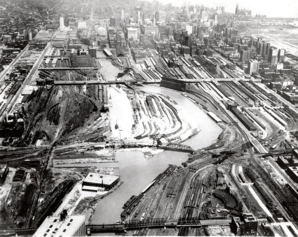
The 78 site was all railyards, with some freighthouses and grain elevators, by the late 19th century. In the late 1920s, remarkably, the railroads agreed to a series of property swaps that allowed the river to be straightened. However, the Depression soon ended the city’s dream of extending LaSalle and Wells through the site.

The land between Clark and the new river channel got some freighthouses and team tracks, but most of it by the 1960s was used for parking trucks used in piggyback (trailer on flatcar) operations. Several long concrete parking pads were laid. Here’s what it looked like in 1970 (the circle is at State & Roosevelt):


NIPC aerial

Bankruptcy of the Rock Island and Penn Central in the 1970s ended most railroad operations, and the land went to the surviving real estate subsidiaries and spinoffs.

In the 1990s, ownership was split, with the land next to the river controlled by one owner and the land next to Clark by another. One planning exercise I was part of absurdly proposed putting the Wells-Wentworth connector right on the property line so neither owner would bear more of the burden. Besides the 1985 White Sox stadium scheme, there was a circa 1990 plan to move the main post office there that Mayor Daley stepped in to block.

In 2001, Rezmar gained control of both parts and began planning a big development. They went through a couple of iterations with IKEA-anchored retail along Roosevelt, and then a retail center without IKEA. When Rezko’s empire collapsed, General Mediterranean bought the dirt. They’re still the actual 90% owner; Related Midwest is just the development partner.

The reason it remained undeveloped is a combination of it having no infrastructure and successive owners holding out for big dreams. Because you have to put in so much street and pipe network at once to get any access from Clark or Roosevelt, you can’t just parcel it out a few acres at a time to townhouse developers. Until about 10 years ago, a bunch of highrise residential just didn’t seem all that realistic on this site. Had Related Midwest not advanced such a big plan a couple of years ago, I fear Amazon would now be looking to swoop in and create its version of the big UPS hub across the river.

People always bring up its brownfield history as a dominant factor, but I don’t think that’s a serious issue. It was just a parking lot and railroad tracks onto which some lubricants and diesel fuel might have spilled. Any remediation would be a simple matter of scraping the top six inches and sending it to a Downstate strip mine. I was happy to see Skidmore dedicate most of the old riverbed as parkland, and that might remove a certain amount of doubt, but the old riverbed was mostly filled in with what they dug from the new channel, so nothing especially evil. The river was only 20 feet deep, so no problem for drilling caissons—but because the river channel had wandered so much over the last 10,000 years, pretty much everything southwest of Polk & Clark has been built on pilings, anyway.
Reply With Quote
     
     
  #977  
Old Posted Sep 26, 2021, 3:47 PM
ardecila's Avatar
ardecila ardecila is offline
TL;DR
 
Join Date: Jun 2006
Location: the city o'wind
Posts: 16,378
The soil under the old riverbed is not a problem for caissons, since you're drilling down to rock or hardpan anyway, but it is a problem for shallow foundations like those you might build for a row of townhouses or a retail pavilion, or even up to 4-5 story buildings. Since it's unlikely that Related will carpet the site with highrises when all is said and done (despite what is shown in renderings), there's bound to be some actual savings from this decision at some point.

That said, I suspect the decision to dedicate the old riverbed to parkland was driven more by a romantic idea than by any serious study of cost savings on foundations, but the savings are a tangible benefit.

I remember one of my former employers was working on a townhouse project just north of Roosevelt and the poor soils in the old riverbed were indeed a concern for the engineers.
__________________
la forme d'une ville change plus vite, hélas! que le coeur d'un mortel...
Reply With Quote
     
     
  #978  
Old Posted Oct 12, 2021, 12:30 AM
thegoatman thegoatman is offline
BANNED
 
Join Date: Oct 2021
Posts: 646
Any news when they'll actually start construction aside from infrastructure work?
Reply With Quote
     
     
  #979  
Old Posted Oct 12, 2021, 2:31 AM
SteelMonkey SteelMonkey is offline
Registered User
 
Join Date: Feb 2016
Location: Chicago
Posts: 344
^^^You have a bit of Geoffrey Baer in you Mr Downtown. Thx for the tidbit on the 78
Reply With Quote
     
     
  #980  
Old Posted Nov 8, 2021, 4:24 PM
Randomguy34's Avatar
Randomguy34 Randomguy34 is offline
Registered User
 
Join Date: Apr 2013
Location: Chicago & Philly
Posts: 2,370
From the new Tribune article on casino locations:

Quote:
Related Midwest President Curt Bailey offered few details but plenty of enthusiasm about the plan, saying it “would work extremely well and probably produce the highest-income casino in the city of Chicago because of the location.”
....
The casino would anchor an entertainment district on the north end of the development at Roosevelt Road, Bailey said.

Bailey declined to give specifics about the casino development, but said Related Midwest, which owns the site, is positioned to move quickly. As to the preliminary budget, he was equally vague.

“A lot,” Bailey said. “It’s a big number. It will be a very large endeavor.”
https://www.chicagotribune.com/news/...4ca-story.html
Reply With Quote
     
     
This discussion thread continues

Use the page links to the lower-right to go to the next page for additional posts
 
 
Reply

Go Back   SkyscraperPage Forum > Global Projects & Construction > General Development
Forum Jump


Forum Jump


All times are GMT. The time now is 7:30 AM.

     
SkyscraperPage.com - Archive - Privacy Statement - Top

Powered by vBulletin® Version 3.8.7
Copyright ©2000 - 2024, vBulletin Solutions, Inc.