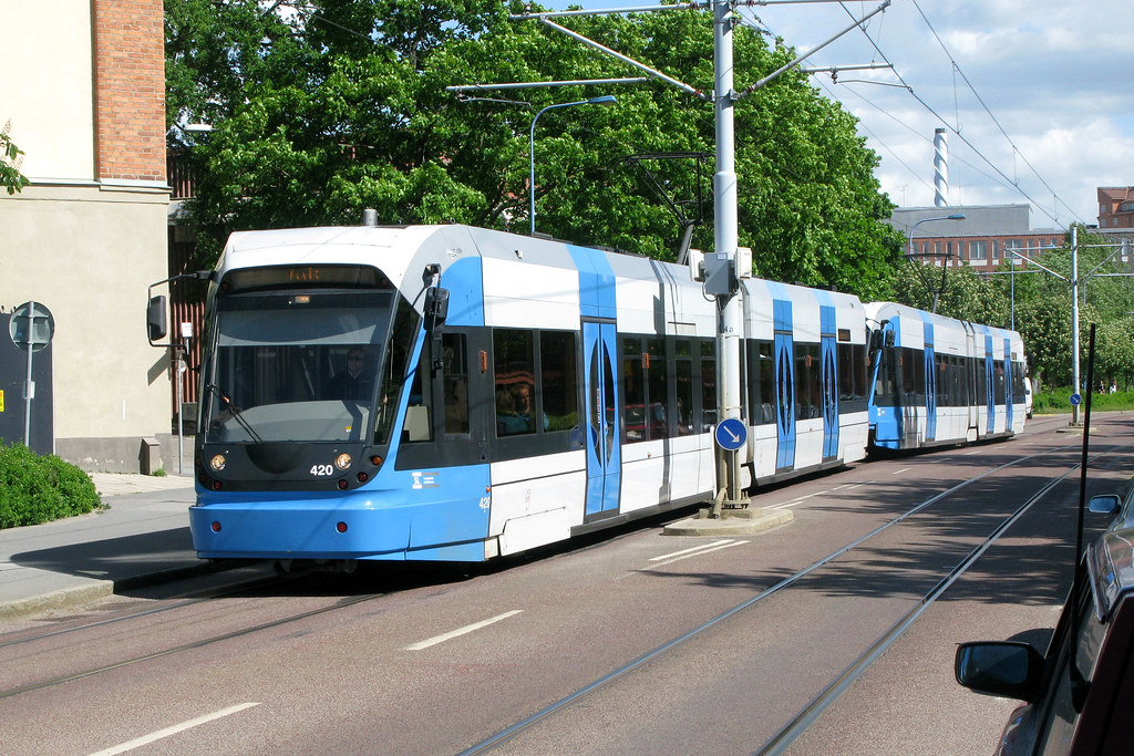
HomeDiagramsDatabaseMapsForum About
     

Go Back   SkyscraperPage Forum > Discussion Forums > Transportation


Reply

 
Thread Tools Display Modes
     
     
  #1  
Old Posted Oct 23, 2015, 4:15 PM
Swede's Avatar
Swede Swede is offline
YIMBY co-founder
 
Join Date: Jul 2001
Location: sol.III.eu.se.08
Posts: 6,758
Stockholm Transport compilation thread

This thread will be mostly a compilation of updates copied from SSC, but I'll start of with the existing rail transit.

100 station subway system (tech once based on the NYC's IND iirc)
53 station commuter rail system
12 stop urban tram line
3 suburban tram lines (10, 13 & 25 stops)
38 station suburban narrow gauge railway (3 branches)
18 station suburban rail line that's kinda LRT but yet not (two small branches at the outer end)
3 station Airport Express train

The map!
This version was introduced this fall and is very different in style to the ones before it.

source

The trains!

Airport Express:

Arlanda Express airport transit train by Gösta Knochenhauer, on Flickr

Commuter rail:

still 09:19 by Gustav Svärd, on Flickr


Subway:

Stahp already by Gustav Svärd, on Flickr

Roslagsbanan (the narrow gauge one):

Stockholm - Roslagsbanan - Rolling stock details by Ingolf, on Flickr

Saltsjöbanan (the kinda LRT one):

Vorortzug der Saltsjöbanan by kaffeeeinstein, on Flickr

Lidingöbanan:

source

Nockebybanan:

Alvik by Ernst Kers, on Flickr

Tvärbanan:

SL 420 [Stockholm tram] Tvärbanan by Howard Pulling, on Flickr

Spårväg City (the urban tram):

Stockholm, Strandvägen 05.07.2015 by The STB, on Flickr
__________________
Forumers met so far:
Huopa, Nightsky, Jo, wolkenkrabber, ThisSideofSteinway, jacksom, New Jack City, LeCom, Ellatur, Jan, Dennis, Ace, Bardamu, AtlanticaC5, Ringil, Dysfunctional, stacey, karakhal, ch1le, Hviid, staff, kjetilab, Þróndeimr, queetz, FREKI, sander, Blue Viking, nomels, Mantas, ristov, Rafal_T, khaan, Chilenofuturista, Jonte Myra, safta20, AW, Pas, Jarmo K, IceCheese, Sideshow_Bob, sk, Ingenioren, Ayreonaut, Silver Creations, Hasse78, Svartmetall

Last edited by Swede; Oct 23, 2015 at 6:53 PM.
Reply With Quote
     
     
  #2  
Old Posted Nov 13, 2015, 1:26 PM
Swede's Avatar
Swede Swede is offline
YIMBY co-founder
 
Join Date: Jul 2001
Location: sol.III.eu.se.08
Posts: 6,758
Two vids about the expansion of the subway in Stockholm:

Video Link


Video Link


Expanding the subway is sorely needed and the extensions of the Blue line (including taking over one of the Green line's three southern branches) make sense. The proposed Yellow line makes very little sense since 1) the Odeplan end station will be a permanent end station! There is no way to extend through the city from the placement of the new track/platform! idiots. 2) The Odenplan-SolnaStation ends of that line are both also commuter rail stations (Odenplan not now, but soon in 2017) and are in fact stations right after eachother on the same line!
__________________
Forumers met so far:
Huopa, Nightsky, Jo, wolkenkrabber, ThisSideofSteinway, jacksom, New Jack City, LeCom, Ellatur, Jan, Dennis, Ace, Bardamu, AtlanticaC5, Ringil, Dysfunctional, stacey, karakhal, ch1le, Hviid, staff, kjetilab, Þróndeimr, queetz, FREKI, sander, Blue Viking, nomels, Mantas, ristov, Rafal_T, khaan, Chilenofuturista, Jonte Myra, safta20, AW, Pas, Jarmo K, IceCheese, Sideshow_Bob, sk, Ingenioren, Ayreonaut, Silver Creations, Hasse78, Svartmetall
Reply With Quote
     
     
  #3  
Old Posted Nov 13, 2015, 1:45 PM
Swede's Avatar
Swede Swede is offline
YIMBY co-founder
 
Join Date: Jul 2001
Location: sol.III.eu.se.08
Posts: 6,758
And here's an alternate map as presented on the TransitMaps tumblr

It has a few mistakes and has some stuff that hasn't been built yet on it, but is IMO far better than the new official map (new since this fall, posted above)

__________________
Forumers met so far:
Huopa, Nightsky, Jo, wolkenkrabber, ThisSideofSteinway, jacksom, New Jack City, LeCom, Ellatur, Jan, Dennis, Ace, Bardamu, AtlanticaC5, Ringil, Dysfunctional, stacey, karakhal, ch1le, Hviid, staff, kjetilab, Þróndeimr, queetz, FREKI, sander, Blue Viking, nomels, Mantas, ristov, Rafal_T, khaan, Chilenofuturista, Jonte Myra, safta20, AW, Pas, Jarmo K, IceCheese, Sideshow_Bob, sk, Ingenioren, Ayreonaut, Silver Creations, Hasse78, Svartmetall
Reply With Quote
     
     
  #4  
Old Posted Nov 13, 2015, 3:37 PM
orulz orulz is offline
Registered User
 
Join Date: Jul 2003
Posts: 585
Is there any official plan to extend the blue line further past Nacka to Orminge? I see this mentioned on blogs and it seems that it would make sense.

It seems that there is an official plan to extend the S22 Tram to Sickla; what about a connection across Saltsjön Bay to the S7 at Waldermarsudde. Or, I suppose that doesn't make sense because there would not be much advantage to that route versus just changing to the Blue line extension uat Sickla.
Reply With Quote
     
     
  #5  
Old Posted Nov 16, 2015, 9:17 AM
Swede's Avatar
Swede Swede is offline
YIMBY co-founder
 
Join Date: Jul 2001
Location: sol.III.eu.se.08
Posts: 6,758
Quote:
Originally Posted by orulz View Post
Is there any official plan to extend the blue line further past Nacka to Orminge? I see this mentioned on blogs and it seems that it would make sense.
No official plans, no, but iirc some of the politicians in Nacka are in favour. Enough in favour that there was a short article in NackaVärmdöPosten (the local paper there).
I dont' think it'll get built at the same time as the bit to Nacka C, but the end station will most likely be built to facilitate this extension.

Quote:
Originally Posted by orulz View Post
It seems that there is an official plan to extend the S22 Tram to Sickla; what about a connection across Saltsjön Bay to the S7 at Waldermarsudde. Or, I suppose that doesn't make sense because there would not be much advantage to that route versus just changing to the Blue line extension uat Sickla.
The extention to Sickla is already under construction. Mostly site prep so far, rockblasting and such.
The extension you propose has been spoken of at times for many years now. IMO it is one that makes sense, but not as an extension from Sickla Station but rather as one branching of from the S22 before the Sickla Udde stop. The point of such a tunnel to Waldermarsudde (and from there extending the line to Ropsten either in tunnel or using the S7/? tracks on the surface) would be very different from taking the Blue line from Sockla Station to T-centralen. A ring line to further turn the hub-and-spokes railtransit we've had into a real net.
__________________
Forumers met so far:
Huopa, Nightsky, Jo, wolkenkrabber, ThisSideofSteinway, jacksom, New Jack City, LeCom, Ellatur, Jan, Dennis, Ace, Bardamu, AtlanticaC5, Ringil, Dysfunctional, stacey, karakhal, ch1le, Hviid, staff, kjetilab, Þróndeimr, queetz, FREKI, sander, Blue Viking, nomels, Mantas, ristov, Rafal_T, khaan, Chilenofuturista, Jonte Myra, safta20, AW, Pas, Jarmo K, IceCheese, Sideshow_Bob, sk, Ingenioren, Ayreonaut, Silver Creations, Hasse78, Svartmetall
Reply With Quote
     
     
  #6  
Old Posted Nov 16, 2015, 2:55 PM
orulz orulz is offline
Registered User
 
Join Date: Jul 2003
Posts: 585
It seems that a tram link could be joined with the eventual completion of the eastern segment of the Stockholm Ring Road, since they would follow pretty much the same route across the bay. Combining the two projects together would mean they could share the cost of the geological study and engineering design, which is a very substantial portion of the costs for projects like this. Likely the entire length would have to be tunneled to avoid slicing up the green space and creating an impediment to marine traffic.

Anyway, thanks for the discussion. The transport network in Stockholm seems to have changed quite a bit since I was there for the first and only time for a short business trip in June 2006.

I stayed at a hotel near Central Station for a week, and commuted on the Tunnelbana from there to my company's office in Liljeholmen, and met with some coworkers at a pub in Medborgarplatsen to watch Sweden draw England in a world cup match. I regret that I was very busy and did not have much time to explore. I did enjoy walking around central Stockholm and maybe the highlight for me was the walk up the hill along Katarinavägen and the view from there over the Saltsjön. I was there for the longest days of the year and found 18+ hours of sunlight to be awesome, great for touring, and the summer weather was absolutely sublime.

To this day I find it baffling that still nothing has been done about the confusing, antiquated, and somewhat scary feeling three layer interchange at Slussen.
Reply With Quote
     
     
  #7  
Old Posted Nov 17, 2015, 2:25 PM
Swede's Avatar
Swede Swede is offline
YIMBY co-founder
 
Join Date: Jul 2001
Location: sol.III.eu.se.08
Posts: 6,758
That section of the ring motorway is likely to get built, sadly it'll get built after the huge western bypass (20+ km of 3+3 lane motorway - all in a tunnel! + on & off ramps that stretch for many km). IMO the obvious thing would be to first build the East Link, then if the need for motorways still ranks above decent urban planning they should go for Diagonal Ulvsunda which is of far greater use and wouldn't lead to as much sprawl.

source

Getting that rail tunnel built at the same time should IMO be a basic requirement for the tunnel to be built at all.
Having LRT (Tvärbanan) going in a ~75% circle around the inner city (it's already today about 50%) will spur people to call for closing that circle. The connection Ropsten-Waldermarsudde-Sickla itself probably won't have much traffic at first. But connect Ropsten to Universitetet and on to Solna Station and the relief to the Red subway will, is my guess, be significant. As will getting areas now outside the Inner City to be thought of and used more as part of the core.

Yeah, since '06 things have been changing. The biggest change is coming on-line in a couple of years though: Citybanan! the commuter trains getting re-routed into a new tunnel under the inner city with the off-ish station Karlberg being replaced by a new station under Odenplan with direct transfers to the Green line subway (and far, far better connectivity to inner city buses).

try going this time of year next time short days, cold, windy and wet. :/

Ah...
Slussen...
Work has begun!
One building in the middle of that proto-cloverleaf is being torn down right now. I'll make a post copying my thread-start in the Stockholm SSC subforum. It's not really that focused on transit, but it IS a very important transit hub.
__________________
Forumers met so far:
Huopa, Nightsky, Jo, wolkenkrabber, ThisSideofSteinway, jacksom, New Jack City, LeCom, Ellatur, Jan, Dennis, Ace, Bardamu, AtlanticaC5, Ringil, Dysfunctional, stacey, karakhal, ch1le, Hviid, staff, kjetilab, Þróndeimr, queetz, FREKI, sander, Blue Viking, nomels, Mantas, ristov, Rafal_T, khaan, Chilenofuturista, Jonte Myra, safta20, AW, Pas, Jarmo K, IceCheese, Sideshow_Bob, sk, Ingenioren, Ayreonaut, Silver Creations, Hasse78, Svartmetall
Reply With Quote
     
     
  #8  
Old Posted Nov 17, 2015, 2:26 PM
Swede's Avatar
Swede Swede is offline
YIMBY co-founder
 
Join Date: Jul 2001
Location: sol.III.eu.se.08
Posts: 6,758
SLUSSEN


Let's start of with a few links:
Official website for the project by the City
Official Twitter by the City
Youtube playlist by the City
Myth-debunking by YIMBY

What exists today:
Decided upon in 1931, completed in 1935.

source


What will be built (all buildings are placeholders, it's the sluice, the bridges, the streets and the park that's decided)
Final court approval in 2013 (and 2014 for the Vattendom), final desicion in the City Council in early fall 2015. Planned completion in 2022+ish.

Three official pics from the City's website:


Source


pic of model, PREVIOUS iteration of the same plan.

source

Video showing the changes (part of the playlist linked above)
Video Link


Quote:
Originally Posted by C30 View Post
It is worth noting that some changes have been made to the plan since the model was built. Part of it is value-engineering: for example, the rounded corners between the footbridges and Södermalm and Gamla Stan seem to have been scrapped, which is a bit of a shame. On the other hand, the landscape architecture has been refined. On the render below, note that the park has been redesigned and that the grand staircase up to Södermalmstorg has mostly been replaced with green terraces. Design work is still ongoing, so even this might not be the final version.


Images by White Arkitekter.

Webcams!
both from http://www.webbkameror.se/webbkamero...olen/index.php


__________________
Forumers met so far:
Huopa, Nightsky, Jo, wolkenkrabber, ThisSideofSteinway, jacksom, New Jack City, LeCom, Ellatur, Jan, Dennis, Ace, Bardamu, AtlanticaC5, Ringil, Dysfunctional, stacey, karakhal, ch1le, Hviid, staff, kjetilab, Þróndeimr, queetz, FREKI, sander, Blue Viking, nomels, Mantas, ristov, Rafal_T, khaan, Chilenofuturista, Jonte Myra, safta20, AW, Pas, Jarmo K, IceCheese, Sideshow_Bob, sk, Ingenioren, Ayreonaut, Silver Creations, Hasse78, Svartmetall
Reply With Quote
     
     
  #9  
Old Posted Nov 17, 2015, 9:09 PM
orulz orulz is offline
Registered User
 
Join Date: Jul 2003
Posts: 585
Those renderings of the Slussen look great. It reminds me a lot of the Wacker Drive and Riverwalk area in Chicago.

That underground bus terminal inside the mountain sounds pretty amazing. Where do the buses from the eastern suburbs that will use this terminal currently stop? It seems like it is going to re-use the existing space of the cold war-era bomb shelter turned parking garage of [link=https://sv.wikipedia.org/wiki/Katarinabergets_skyddsrum]Katarinabergets skyddsrum[/link]. It seems the entrances along Katarinavägen dug into the hill will be converted for passengers? How much does the underground space have to be expanded? Does the pedestrian tunnel from there to the Tunnelbana already exist? Seems there is a new entrance from Stadsgårdsleden for buses as well, how will that be built?

The Saltsjöbanan gets a new station and a double track approach. How far will this double tracking extend, and how will it be built, a new bore through the rock or perhaps taking space from Stadsgårdsleden?

Sorry for all the questions. You are right though, this is an important transport hub, and in my opinion, one of the most fascinating pieces of transportation infrastructure in the world.
Reply With Quote
     
     
  #10  
Old Posted Nov 18, 2015, 2:46 PM
Swede's Avatar
Swede Swede is offline
YIMBY co-founder
 
Join Date: Jul 2001
Location: sol.III.eu.se.08
Posts: 6,758
Quote:
Originally Posted by orulz View Post
That underground bus terminal inside the mountain sounds pretty amazing. Where do the buses from the eastern suburbs that will use this terminal currently stop?
Under all that concrete. Just north of all those ramps, just south of the subway station. The subway goes above part of the bus terminal (with parking for buses to the west of the subway). All at quay level.

This is what part of it looks like:

20150812_123051 by Gustav Svärd, on Flickr

Quote:
Originally Posted by orulz View Post
It seems like it is going to re-use the existing space of the cold war-era bomb shelter turned parking garage of [link=https://sv.wikipedia.org/wiki/Katarinabergets_skyddsrum]Katarinabergets skyddsrum[/link]. It seems the entrances along Katarinavägen dug into the hill will be converted for passengers? How much does the underground space have to be expanded?
Nope, it won't use that old bomb shelter. It's pretty much all new. The entrance will re-use on of the entrances to the bomb shelter tho.
The bus terminal has NOT cleared all the planning and political step yet it was close, but had to start over due to mistakes in how the process of planning was done. Not due to flaws in the plans, just in the process.

Quote:
Originally Posted by orulz View Post
Does the pedestrian tunnel from there to the Tunnelbana already exist?
Nope.

Quote:
Originally Posted by orulz View Post
Seems there is a new entrance from Stadsgårdsleden for buses as well, how will that be built?
Blasting. That's how tunnels are dug here. Wrong rocks for TBMs iirc.

Quote:
Originally Posted by orulz View Post
The Saltsjöbanan gets a new station and a double track approach. How far will this double tracking extend, and how will it be built, a new bore through the rock or perhaps taking space from Stadsgårdsleden?
It won't go far at all, sadly. Basically just the station. There have been a couple of different plans presented over the last 15 years to get double tracking from Henriksdal to Slussen, but none got close to construction. I do expect it to happen eventually tho, the increased capacity is just so useful.

Quote:
Originally Posted by orulz View Post
Sorry for all the questions. You are right though, this is an important transport hub, and in my opinion, one of the most fascinating pieces of transportation infrastructure in the world.

Slussen and Centralen are the two really interesting infra-hubs in Stockholm IMO. After Citybanan is done Stockholm Central will have 5 levels of rail, 3 levels with bus/coach stops and 3 mezzanine levels for a total of 10 levels (bus & rail share one level).
__________________
Forumers met so far:
Huopa, Nightsky, Jo, wolkenkrabber, ThisSideofSteinway, jacksom, New Jack City, LeCom, Ellatur, Jan, Dennis, Ace, Bardamu, AtlanticaC5, Ringil, Dysfunctional, stacey, karakhal, ch1le, Hviid, staff, kjetilab, Þróndeimr, queetz, FREKI, sander, Blue Viking, nomels, Mantas, ristov, Rafal_T, khaan, Chilenofuturista, Jonte Myra, safta20, AW, Pas, Jarmo K, IceCheese, Sideshow_Bob, sk, Ingenioren, Ayreonaut, Silver Creations, Hasse78, Svartmetall
Reply With Quote
     
     
  #11  
Old Posted Nov 18, 2015, 8:02 PM
orulz orulz is offline
Registered User
 
Join Date: Jul 2003
Posts: 585
Quote:
Originally Posted by Swede View Post
Nope, it won't use that old bomb shelter. It's pretty much all new. The entrance will re-use on of the entrances to the bomb shelter tho.
What will become of the old bomb shelter-turned-gas-station/parking-garage? Surely they will not fill it in, and surely it will not just continue to be parking and a gas station since it is losing at least one of its entrances?
Reply With Quote
     
     
  #12  
Old Posted Nov 18, 2015, 8:14 PM
orulz orulz is offline
Registered User
 
Join Date: Jul 2003
Posts: 585
Quote:
Originally Posted by Swede View Post
It won't go far at all, sadly. Basically just the station. There have been a couple of different plans presented over the last 15 years to get double tracking from Henriksdal to Slussen, but none got close to construction. I do expect it to happen eventually tho, the increased capacity is just so useful.
Maybe if the eastern link of the ring road is completed, that would remove enough traffic from Stadsgårdsleden to remove a lane (or lanes) of traffic. That would be a cheap way to add that second Saltsjöbanan track (if you take the eastern ring road as given.)

I do recall feeling that it was a shame to have basically six-lane expressway hemmed in along the waterfront. Certainly there is a great deal of elevation change from Katarina-Sofia to the water level but even if there was some way to go up and down the cliff, be it a stairway, elevator, or funicular, there would still be a big highway in the way. They are planning on putting a cap over Stadsgårdsleden for what looks like about 300m east of Slussen. How about extend that cap 1km further east and incorporate a second track for the Saltsjöbanan under it.

Last edited by orulz; Nov 18, 2015 at 8:33 PM.
Reply With Quote
     
     
  #13  
Old Posted Nov 19, 2015, 9:51 AM
Swede's Avatar
Swede Swede is offline
YIMBY co-founder
 
Join Date: Jul 2001
Location: sol.III.eu.se.08
Posts: 6,758
Quote:
Originally Posted by orulz View Post
What will become of the old bomb shelter-turned-gas-station/parking-garage? Surely they will not fill it in, and surely it will not just continue to be parking and a gas station since it is losing at least one of its entrances?
As I understand it it'll lose the gas station, but keep the parking. It'll have a single entrance so parking should work nicely (these entrances are big)

Quote:
Originally Posted by orulz View Post
Maybe if the eastern link of the ring road is completed, that would remove enough traffic from Stadsgårdsleden to remove a lane (or lanes) of traffic. That would be a cheap way to add that second Saltsjöbanan track (if you take the eastern ring road as given.)
You're not alone in thinking this way. Nothing official or even clearly proposed by politicians, but the idea is around.

Quote:
Originally Posted by orulz View Post
I do recall feeling that it was a shame to have basically six-lane expressway hemmed in along the waterfront. Certainly there is a great deal of elevation change from Katarina-Sofia to the water level but even if there was some way to go up and down the cliff, be it a stairway, elevator, or funicular, there would still be a big highway in the way.
Yeah, that highway needs to go for the area to spring to life.

Quote:
Originally Posted by orulz View Post
They are planning on putting a cap over Stadsgårdsleden for what looks like about 300m east of Slussen. How about extend that cap 1km further east and incorporate a second track for the Saltsjöbanan under it.
You're not the only one with that idea too extending the cap all the way till the space widens out has been proposed at times for many years. Do that and you could take a lane or two from cars and add a second track to Saltsjöbanan.
__________________
Forumers met so far:
Huopa, Nightsky, Jo, wolkenkrabber, ThisSideofSteinway, jacksom, New Jack City, LeCom, Ellatur, Jan, Dennis, Ace, Bardamu, AtlanticaC5, Ringil, Dysfunctional, stacey, karakhal, ch1le, Hviid, staff, kjetilab, Þróndeimr, queetz, FREKI, sander, Blue Viking, nomels, Mantas, ristov, Rafal_T, khaan, Chilenofuturista, Jonte Myra, safta20, AW, Pas, Jarmo K, IceCheese, Sideshow_Bob, sk, Ingenioren, Ayreonaut, Silver Creations, Hasse78, Svartmetall
Reply With Quote
     
     
  #14  
Old Posted Jan 27, 2016, 7:57 AM
Swede's Avatar
Swede Swede is offline
YIMBY co-founder
 
Join Date: Jul 2001
Location: sol.III.eu.se.08
Posts: 6,758
Citybanan

Not in the [a] city banana sense, but the City line sense. ("the ... line" when referring to the infrastructure is "...banan" wh) ich is also how we spell banana in Swedish).

Citybanan is a new tunnel under the inner city for the commuter trains. Unlike some other cities we've had these trains through-running for over a century, but the capacity of the tracks was reached some years ago for the rush hours. We've got two tracks from Stockholm Central to Stockholm Södra, which is how it's been for about 130 years now.
Citybanan adds 2 new tracks in a tunnel from Stockholm Södra via Stockholm Central and Odenplan to just north of the inner city. It'll create a huge capacity boost and a far better northern inner city station for the commuter trains (with transfer to the subway and a bus hub).


Huge map: http://www.trafikverket.se/contentas..._120102--2.jpg

Map:

http://<font size="1">http://www.tra...ybanan/</font>

Intro video:
Video Link


Latest video:
Video Link
__________________
Forumers met so far:
Huopa, Nightsky, Jo, wolkenkrabber, ThisSideofSteinway, jacksom, New Jack City, LeCom, Ellatur, Jan, Dennis, Ace, Bardamu, AtlanticaC5, Ringil, Dysfunctional, stacey, karakhal, ch1le, Hviid, staff, kjetilab, Þróndeimr, queetz, FREKI, sander, Blue Viking, nomels, Mantas, ristov, Rafal_T, khaan, Chilenofuturista, Jonte Myra, safta20, AW, Pas, Jarmo K, IceCheese, Sideshow_Bob, sk, Ingenioren, Ayreonaut, Silver Creations, Hasse78, Svartmetall
Reply With Quote
     
     
  #15  
Old Posted Jul 12, 2016, 12:33 PM
Swede's Avatar
Swede Swede is offline
YIMBY co-founder
 
Join Date: Jul 2001
Location: sol.III.eu.se.08
Posts: 6,758
The latest update on the City Line:
Video Link
__________________
Forumers met so far:
Huopa, Nightsky, Jo, wolkenkrabber, ThisSideofSteinway, jacksom, New Jack City, LeCom, Ellatur, Jan, Dennis, Ace, Bardamu, AtlanticaC5, Ringil, Dysfunctional, stacey, karakhal, ch1le, Hviid, staff, kjetilab, Þróndeimr, queetz, FREKI, sander, Blue Viking, nomels, Mantas, ristov, Rafal_T, khaan, Chilenofuturista, Jonte Myra, safta20, AW, Pas, Jarmo K, IceCheese, Sideshow_Bob, sk, Ingenioren, Ayreonaut, Silver Creations, Hasse78, Svartmetall
Reply With Quote
     
     
  #16  
Old Posted Jul 12, 2016, 2:44 PM
Swede's Avatar
Swede Swede is offline
YIMBY co-founder
 
Join Date: Jul 2001
Location: sol.III.eu.se.08
Posts: 6,758
Tvärbanan!

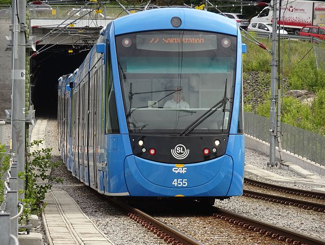
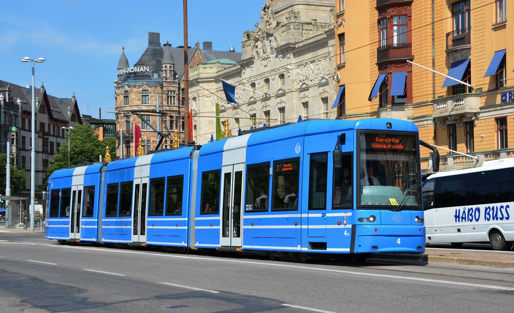
old A32 trams (Flexity Swift) pic from wiki


new A35 trams (Urbos AXL) pic from wiki


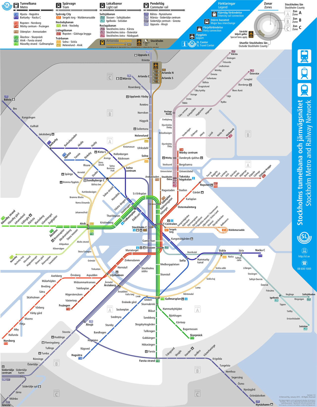
Map from a few years ago. What's u/c or not is out of date, but these are the lines built, u/c and planned. pic from https://stockholmiana.wordpress.com/, originally from SL


Tvärbanan is a Light Rail Line that has some street running sections. It was somewhat controversial when it was built and some said almost no-one would use it and the parking it removed from one neighborhood would kill the local shops. Of course, that didn't happen. Very successful and has lifted that neighborhood to near inner-city level.

History:
2000-01-08 Liljeholmen - Gullmarsplan (central part of the green section, the ends have transfers to the Red and Green subway lines, respectively)
2000-06-01 Liljeholmen - Alvik (western part of green section, connecting to the Green subway line on the other side of the Inner City from the one at Gullmarsplan as well as to the old suburban Nockebybanan tram line)
2002-08-14 Gullmarsplan - Sickla Udde (giving vastly better transit options to the Hammarby Sjöstad re-development area)
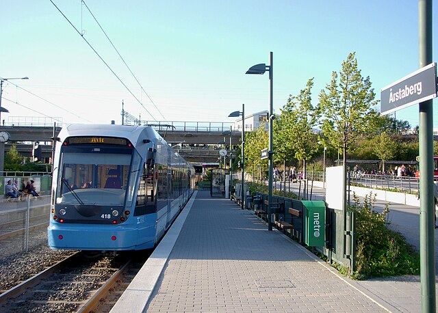
2006-01-09 new transfer to commuter rail at Årstaberg (existing Tvärbanan stop, new commuter rail station just for that transfer)
North expansion that is still in 2016 not thru-running with the old section(!):
2013-10-28 Alvik - Solna Centrum (transfer to the Blue subway and to commuter rail at Sundbyberg, to the other branch of the Blue line at SolnaC)
2014-08-18 Solna Centrum - Solna Station(transfer to the other northern branch of the commuter rail)
Currently under construction:
2017? Sickla Udde - Sickla Station (will connect to Saltsjöbanan, a sorta LRT-ish commuter rail-ish line)
Planned:
Norra Ulvsunda - Helelund (transfers to both branches of the Blue line and ending with a transfer to commuter rail)

Alvik - Sickla Udde 11.5 km & 17 stops
Alvik - Solna Station 6.7 km & 8 stops
i.e. SolnaS - SicklaU 17.2 km & 25 stops
Extension to Sickla Station is under a km and 1 stop.
i.e. SolnaS - SicklaS 18 km & 26 stops.

Passenger numbers (per normal weekday):
2005: . 32 000
2007: . 44 000
2012: . 57 700
2014: . 62 000 for the main part, 13 000 for the northern part
2018: 110 000 for the whole line finally with thru-running and with the Sickla Station expansion.

The on-going f***-up that is the new signalling system was supposed to take about a year to get operational on the new northern extension. so was supposed to work after summer 2014. Still does not work. F*** GE and f*** the incompetence at SL that made the specs for the system. Hopefully it'll all work after summer 2017, when we might also see the Sickla Station extension go into service.
__________________
Forumers met so far:
Huopa, Nightsky, Jo, wolkenkrabber, ThisSideofSteinway, jacksom, New Jack City, LeCom, Ellatur, Jan, Dennis, Ace, Bardamu, AtlanticaC5, Ringil, Dysfunctional, stacey, karakhal, ch1le, Hviid, staff, kjetilab, Þróndeimr, queetz, FREKI, sander, Blue Viking, nomels, Mantas, ristov, Rafal_T, khaan, Chilenofuturista, Jonte Myra, safta20, AW, Pas, Jarmo K, IceCheese, Sideshow_Bob, sk, Ingenioren, Ayreonaut, Silver Creations, Hasse78, Svartmetall
Reply With Quote
     
     
  #17  
Old Posted Jul 18, 2016, 11:43 AM
Swede's Avatar
Swede Swede is offline
YIMBY co-founder
 
Join Date: Jul 2001
Location: sol.III.eu.se.08
Posts: 6,758
Let's see if this works...
EDIT: it didn't. Click the photo or link and you'll go to Flickr where there's a video of the same scene. I guess they don't do imbeded links of videos just yet.

Tunnelbanerace 20160715 by Gustav Svärd, on Flickr
__________________
Forumers met so far:
Huopa, Nightsky, Jo, wolkenkrabber, ThisSideofSteinway, jacksom, New Jack City, LeCom, Ellatur, Jan, Dennis, Ace, Bardamu, AtlanticaC5, Ringil, Dysfunctional, stacey, karakhal, ch1le, Hviid, staff, kjetilab, Þróndeimr, queetz, FREKI, sander, Blue Viking, nomels, Mantas, ristov, Rafal_T, khaan, Chilenofuturista, Jonte Myra, safta20, AW, Pas, Jarmo K, IceCheese, Sideshow_Bob, sk, Ingenioren, Ayreonaut, Silver Creations, Hasse78, Svartmetall
Reply With Quote
     
     
  #18  
Old Posted Nov 17, 2016, 6:54 PM
Swede's Avatar
Swede Swede is offline
YIMBY co-founder
 
Join Date: Jul 2001
Location: sol.III.eu.se.08
Posts: 6,758
Citybanan (the put-commuter-rail-in-a-tunnel project) has posted several new aerials of their sites on their flickr account.

First the Central Station area. The new white highrise has the main exit from the new station "City" for the commuter rail (old station for them is the saame Central Station as the regional/national/internationel trains)


LR 20160926 6521 Sta Clara_OP6_Klarabgsg by Projekt Citybanan, on Flickr


LR 20160926 3341 Cst bang_DLC_Klara sjö by Projekt Citybanan, on Flickr


LR 20160926 6491 Cst banomr söderifrån by Projekt Citybanan, on Flickr


That whole graveled area was part of the construction site for the tunnel in this area. Before the project there was a "moat" with rail crossing the area (since the late 1800s iirc) but now it'll all be covered which means it'll be one united park people can walk across. Will be interesting to see how this affects how people use the place.


LR 20160926 2491 blivande Fatburspark by Projekt Citybanan, on Flickr


LR 20160926 2321 Hela Sth o Täppan i Bofills båge by Projekt Citybanan, on Flickr


Odenplan. most of the square got dug up and the entrence to the subway & commuter rail is a way better building than the old one for the subway. Not as good as the renders made it seem, but pretty decent. The other new building on the square is the entrence to an underground bike garage.


LR 20160926 6741 by Projekt Citybanan, on Flickr


LR 20160926 7491 by Projekt Citybanan, on Flickr


Below the waters hither of the bridges is a sunken tunnel the commuter rail will use. No trace of the construction sites left! But a bonus shot of the destruction of the old Slussen


LR 20160926 2931 Söderström_Slussen_Saltsjön by Projekt Citybanan, on Flickr


The northern entrence to the new tunnel. With the Tomtebode central mail terminal and goods yard on the left and Karolinska Institutet on the right (the top medical university & research institue in Sweden who also pick the winners of the medical Nobels)

LR 20160926 7091 by Projekt Citybanan, on Flickr

Same place, but looking in the other direction. Sadly, this is the size they uploaded it as so I can't even link to a big version

LR 20160926 4251 CBnedfart hela Sth by Projekt Citybanan, on Flickr
__________________
Forumers met so far:
Huopa, Nightsky, Jo, wolkenkrabber, ThisSideofSteinway, jacksom, New Jack City, LeCom, Ellatur, Jan, Dennis, Ace, Bardamu, AtlanticaC5, Ringil, Dysfunctional, stacey, karakhal, ch1le, Hviid, staff, kjetilab, Þróndeimr, queetz, FREKI, sander, Blue Viking, nomels, Mantas, ristov, Rafal_T, khaan, Chilenofuturista, Jonte Myra, safta20, AW, Pas, Jarmo K, IceCheese, Sideshow_Bob, sk, Ingenioren, Ayreonaut, Silver Creations, Hasse78, Svartmetall

Last edited by Swede; Nov 17, 2016 at 7:08 PM.
Reply With Quote
     
     
  #19  
Old Posted Nov 24, 2016, 1:52 PM
Swede's Avatar
Swede Swede is offline
YIMBY co-founder
 
Join Date: Jul 2001
Location: sol.III.eu.se.08
Posts: 6,758
The biggest motorway project currently is Förbifart Stockholm (i.e. By Pass Stockholm).


source: wiki

It's 21 km of 3+3 motorway of which 17 km are in tunnel.
The on/off ramp tunnels for for the interchange in the middle of it will together be about 7.5 km long.

The stated purpose of it is to decrease traffic on the main arteries closer to the city by removing all the by-pass traffic. Stated purpose. Not what Trafikverket's own reports says will happen tho, of course since that's not how motorways in cities work. It'll increase the amount of car traffic and even the modal share of cars according to the reports by Trafikverket.
But hey, it's not like cars and sprawl ever caused any harm, right?

Before & After starting at the northern end and going south: (all sourced from the Trafikverket website)

Häggvik
Before


After


Akalla:
Before


After


Hjulsta
Before


After


Vinsta:
before


after


Lovön:
Before


After


Kungens Kurva
Before


After
__________________
Forumers met so far:
Huopa, Nightsky, Jo, wolkenkrabber, ThisSideofSteinway, jacksom, New Jack City, LeCom, Ellatur, Jan, Dennis, Ace, Bardamu, AtlanticaC5, Ringil, Dysfunctional, stacey, karakhal, ch1le, Hviid, staff, kjetilab, Þróndeimr, queetz, FREKI, sander, Blue Viking, nomels, Mantas, ristov, Rafal_T, khaan, Chilenofuturista, Jonte Myra, safta20, AW, Pas, Jarmo K, IceCheese, Sideshow_Bob, sk, Ingenioren, Ayreonaut, Silver Creations, Hasse78, Svartmetall
Reply With Quote
     
     
  #20  
Old Posted Jan 5, 2017, 10:02 AM
Swede's Avatar
Swede Swede is offline
YIMBY co-founder
 
Join Date: Jul 2001
Location: sol.III.eu.se.08
Posts: 6,758
Video Link


No more zones!
As of the coming monday SL are abolishing the ticket zones. The new fares will be higher than the old single zone fare, but cheaper than the old two zone fare. And the price of weekly, monthly, yearly ... cards is going up.
__________________
Forumers met so far:
Huopa, Nightsky, Jo, wolkenkrabber, ThisSideofSteinway, jacksom, New Jack City, LeCom, Ellatur, Jan, Dennis, Ace, Bardamu, AtlanticaC5, Ringil, Dysfunctional, stacey, karakhal, ch1le, Hviid, staff, kjetilab, Þróndeimr, queetz, FREKI, sander, Blue Viking, nomels, Mantas, ristov, Rafal_T, khaan, Chilenofuturista, Jonte Myra, safta20, AW, Pas, Jarmo K, IceCheese, Sideshow_Bob, sk, Ingenioren, Ayreonaut, Silver Creations, Hasse78, Svartmetall
Reply With Quote
     
     
This discussion thread continues

Use the page links to the lower-right to go to the next page for additional posts
 
 
Reply

Go Back   SkyscraperPage Forum > Discussion Forums > Transportation
Forum Jump


Forum Jump


All times are GMT. The time now is 8:53 PM.

     
SkyscraperPage.com - Archive - Privacy Statement - Top

Powered by vBulletin® Version 3.8.7
Copyright ©2000 - 2024, vBulletin Solutions, Inc.