Quote:
Originally Posted by Johnland

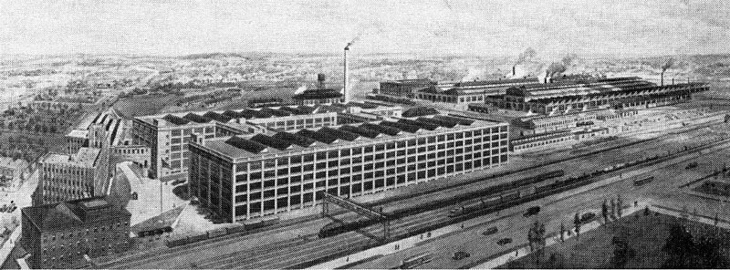
As much as I've read about Pittsburgh history, I always find yet new information revealing even more history. Lately I've been fascinated by East Liberty. When I moved to Pittsburgh in the 70's, East Liberty was already run down and desolate. It wasn't until recently that I learned how big and developed it was in the first half of the 1900's. The train station there (where the Village of Eastside shopping center is now), a few stops inbound from Swissvale, had 100 trains a day. Assuming they ran between 8 am and 8 pm, that's a train in less than every ten minutes. So without a car, one could've lived in East Liberty and easily worked at the Switch.
|
I particularly like the aerial photo map from 1939 for exploring this period, available here:
https://www.arcgis.com/apps/View/ind...9dfc5bf6828126
1939 is early enough to be before the Parkway, and generally still within the peak period of East End railroad-related development.
Out on the eastern border of that map, you can see the PRR Main Line coming in and the complex we were talking about in Edgewood/Swissvale.
Tracing along the PRR, there is then a big railyard and industrial complex in Wilkinsburg/Homewood. The railyard is now the Wilkinsburg Park and Ride, and you can see how the dense residential develop of 1939 has a lot of new green gaps today. But still, a lot of the industrial buildings survived and are now being incorporated into the Rockwell Park development and such.
Tracing further you get to the massive railyard and industrial complex that is now a combination of things like the East Liberty PAT garage, Bakery Square, the strip malls, and the "gated community"-style residential development. Unfortunately a lot more of that was lost, but on the plus side it is gaining a lot of new stuff.
East Liberty is then basically a small city of its own, and finally you pass through the densely-developed Shadyside and the railroad dips into the ravine, heading for Lawrencville and the Strip, and finally Downtown.
If you want to depress yourself, you can center on East Liberty and click on the 1957 layer--still very impressive--and then the 1967 layer, where it looks like East Liberty just went through WW II-style bombing. Ugh.
Anyway, I believe pretty strongly that the fundamentals that led to those developments back in the day have evolved but never really gone away, and therefore these nodes can continue to anchor new developments going forward. And although not quickly, it does seem to be happening.


 Prev
Prev


 Linear Mode
