[QUOTE=Migrant_Coconut;9504051]You're overlooking 7.4.2 and 7.4.3: elevated stations and impacts to the street and businesses. A 5-7m guideway on a ~20m wide street blocks out most of the sun for most of the day, and a 20m wide station means you need to level both sides of the block and create an equivalent setback for the redevelopment. Cambie/Lougheed get away with it because they're wider, and the businesses aren't streetfronts that go up to the property line; it's not going to end well if you try and pitch that to Sunset or Burnaby Heights.
Thing is, if we're worried about effects on street businesses and lack of lighting (rather than just noise), we should consider the entire width of the roadway (widewalks and roads). That gives you 30m on Broadway, Lougheed is 35m (depending on where you measure it, including sidewalks. Width varies from 30m to 40m+.)
So assuming we
really need those 5 m, that's 2.5m on each side for future redevelopments.

A lot of the new(er) buildings, like 78 E Broadway already have maybe 0.5-1m setbacks from the existing road/old streetfront line.
I don't think this is a deal-breaker.
Also, the businesses that are being built DO frequently have streetfront shops (the Amazing Brentwood).
Also, regarding stations:
Quote:
Stations located along the elevated guideway would have land requirements similar to the tunneled
option.
|
That leaves NIMBYs. Which you're probably right about.
Quote:
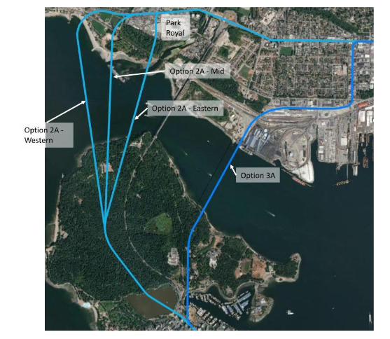
TransLink said it. An independent line isn't on the table at the moment, if ever; all current options utilize existing Expo depots and OMCs. In the case of First Narrows/Norgate, the line would branch off from Burrard and go to Central Lonsdale (replacing the 240), and Norgate would most likely have a station at Welch, then Pemberton, then Cap Mall. AFAIK the latter isn't much of a destination either.
Since we're not counting the Phibbs redevelopment, Second Narrows connects to Park & Tilford and Lonsdale Quay in every option.
Because you said that Second Narrows is an inferior route for NS commuters. It's not, so long as it goes all the way from Phibbs to PR... which Norgate definitely doesn't.
Methinks you misread part of my comment: that 32% of traffic headed to Vancouver is split between both Narrows.
|
1. The issue's not Phibbs, the issue is the high slope and lack of development potential/existence from Phibbs to St. Davids Ave.
2. If we're going to be
purist to the original report, there's no connection on Gold and Purple to Park Royal. Also, all options end at Lonsdale.
3.
Quote:
|
An independent line isn't on the table at the moment, if ever;
|
Purple is an independent line on the report, so I guess that's off the table?
There's not much of a reason for a station at Welch. Now that I look at it closer, the Welch location is most likely due to the lack of space further east to make an exit/entrance.
My guess as to why it's going what it is is due to this being an alignment study, not a comprehensive report on the alternatives- so you'd want to simplify 3A by assuming a connection to Expo rather than an extension to eg. Hastings. If so, you'd see cost/benefit analyses and station locations.
Quote:
|
Trucks aren't buses. Not only are you going to have a hard time turning a bus lane into a truck lane, you're going to have an equally hard time getting cars not to follow. Far as they're concerned, it means "general traffic is welcome."
|
Pretty sure once the fines start rolling in, people will realize that they should probably follow the signs.


 Prev
Prev


 Linear Mode
