some interesting discussion in this thread about boat access/waterfront development
http://forum.skyscraperpage.com/showthread.php?t=200308&page=3
I think Ottawa could really use some urban waterfront development considering how much river frontage we do have in the City (although boating in some major sections of Ottawa's waterfront is limited, and some of the land on the Ottawa side is too steep). Besides one-off structures such as the Canal Ritz and Dow's Lake Pavillion, we don't have much waterfront development in our City. It's also interesting to compare the master planning in the below developments versus the LeBreton Flats and the Bayview CDP. Unfortunately they waterfront seems to be off-limits in both of those cases, although perhaps the aqueduct will turn out well.
Here are a few waterfront development districts for inspiration, using mostly reclaimed land. These are a treat to explore on Streetview
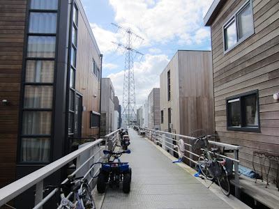
Sluseholmen
Streetview
http://goo.gl/maps/JAgl4
http://en.wikipedia.org/wiki/Sluseholmen
http://en.wikipedia.org/wiki/Sluseholmen_Canal_District

Quote:
Sluseholmen Canal District (Danish: Sluseholmen Kanalby) is a residential development, located on Sluseholmen peninsula in the South Harbour area of Copenhagen, Denmark. The development comprises 1,350 apartments built on eight artificial islands, separated by dug-out canals. On each island is a closed block, 4-7 stories tall, surrounding a sheltered courtyard with public access. The houses frequently stand directly on the canals, while bridges, wharfs and "ghats" create direct contact to the water.
The development was designed by the Danish architecture firm Arkitema in collaboration with the Dutch architect Sjoerd Soeters but to ensure a varied cityscape, the facades of the individual townhouses were designed by 20 different architecture practices.
|
IJburg
Streetview (more "suburban")
http://goo.gl/maps/Bj5xq
http://en.wikipedia.org/wiki/IJburg
http://gellersworldtravel.blogspot.ca/2012/04/floating-amsterdam.html
 Java Island
Streetview
http://goo.gl/maps/4Rkqh
http://en.wikipedia.org/wiki/Java-eiland
 Hammarby Sjöstad
Streetview
http://goo.gl/maps/2NIf3
 http://www.hammarbysjostad.se/inenglish/pdf/HS_miljo_bok_eng_ny.pdf
Any redevelopment of Chaudiere Island or other major waterfront pieces should look to these types of developments for inspiration. If the Parkway is chosen as the LRT route, some type of development like this could make much better use of the station locations and facilitate closer stop locations, and it would be quite appropriate for the area around Dominion
Any other good examples people know of? The Bayview area actually has a decent amount of reclaimed land btw
http://www.youtube.com/watch?v=5vmAkxp44hk&feature=channel_video_title


 Threaded Mode