Quote:
|
http://www.suntimes.com/news/cityhal...outh-side.html
Quote:
|
^^
That I dig. Roscoe Village and south could certainly use a rapid transit connection. ^ CTA is getting perilously close to the point where even after the slow zone work on the red line, there will still be the same amount of slow zones as there were when the project was first announced. That was stated poorly, basically, if you take Sept. 2012 slow zones and subtract the Dan Ryan slow zones, it equals the slow zones that existed in June 2012 when they announced the Dan Ryan project. I am not sure how much the north side slow zone work will accomplish so I did not subtract that. But after all the hand wringing about how bad the slow zones on the Dan Ryan branch are, the Congress branch is almost as bad and slow zones have been popping up on all tracks between Belmont and Fullerton. CTA cannot fix them fast enough. It seems to me, that city hall and the various agencies are very gung-ho and self congratulatory even though the actual results are not large. For every new protected bike lane, small though that number might be, there is twice as many striped bike lanes made useless by Comed or Peoples tearing up the pavement. It seems like we are just barely treading water. Either that or maybe I am just too pessimistic. |
Maintenance should be a constant in a transit agency—you can’t just build or fix something and then let it sit around for twenty years. I’m not sure about the CTA’s regular rail schedule maintenance, but it sometimes seems like they defer until they can get a state/federal grant to fix things, which certainly isn’t the wisest choice—it leads to service deterioration over a long period, followed by a short period of increased disruption once things are fixed (the city’s culture of measure once, repair [and ask for bids] twice doesn’t help, either).
|
We're burdened by an antiquated system that requires more frequent and expensive maintenance. Tracks and switches still rest on old wood ties and in some parts, century old support structures. It's like maintaining an old car. You can put in new components, but the pieces seems to fail more quickly.
While I agree that maintenance should be constant, a good modernized system requires less attention if it's built to last. In a perfect world, entire sections of the red line subway, and red line North branch would totally be demolished and rebuilt because they're obsolete. There's nothing acceptable about their design and operation here in the 21st century. |
We've got a mostly-outdoor system with heavy traffic in a cold climate. It's like, the worst possible combination for maintenance.
The elevated lines are bad, but the expressway-median lines are even worse. They sit in a trench, so they have all the drainage problems of a subway, yet they're exposed to the elements and even an increased percentage of exposure since they're surrounded by an expressway that kicks up salty mist. Mr. D posted an intriguing landscape proposal for the extra space in the Eisenhower median... presumably the landscaping would improve the environment around tracks and platforms by restricting the salt mist and soaking up the rain. A landscape barrier and swale system could work wonders. |
Red Line Shutdown Yahoo Group
I have just created a new Yahoo Group "Red Line Shutdown" to acquire and distribute Information, Ideas, and Comments about the Shutdown;
and I will be asking Harvey Kahler to be an additional Moderator for the Group: http://finance.groups.yahoo.com/group/REDLINESHUTDOWN/ Please consider joining the Group, and giving us access to your GREAT STOREHOUSE of knowledge - as you guys know A LOT about Chicago's Transit situation and Infrastructure. The Group is still in the process of being set-up, so it may be a while before it is working correctly; any suggestions on how to make it work better? (And N O - I am N O T going to Delete it) Thanks - and Welcome, Mike Payne |
Schematic Design, Cermak Green Line Station
http://imageshack.us/a/img254/9994/c...nstation02.jpg Taking inspiration from Koolhaas and Goldberg's nearby buildings. Reminds me of some of Vancouver's new stations, too. |
^ url points to a file named "ctamorganstation02.jpg" - can you please confirm you have not gotten folks like me extremely excited for naught? I realize the streets shown aren't consistent with Morgan, but to be sure...
|
Quote:
That's definitely Cermak. |
Alley L crossing center median. Can't possibly be Morgan.
|
I dont see any stationhouse in that picture. That might be an important part to see too. Are people supposed to jump down off the platform to get to the street?
|
|
Pretty cool!
|
Quote:
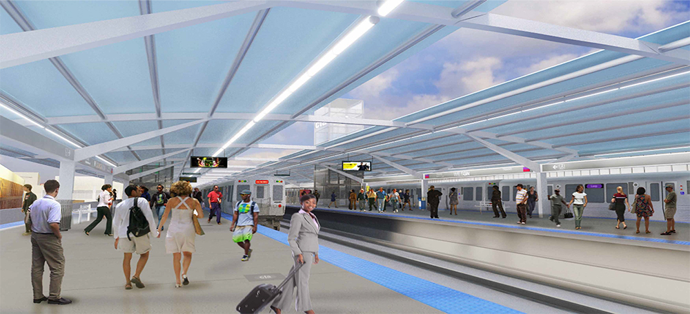
You can remain excited. The rendering shows the White Castle on the corner of Wabash & Cermak, looking towards the SW. Is it just me or is the CTA kicking ass recently with these great station designs? Of course Morgan St. Station immediately comes to mind, but the 95th St. Bus Terminal, Cermak Green and now Wilson Station look effin' fantastic. |
Does any one know when this part of 90 connected to Ohio? This is such a cool interchange to me. Are there any pics of what it looked like prior to this? Also, this new map app is awesome! I've been flying all around Chicago and other cities! Definitely cool for us skyscraper folks.
http://i592.photobucket.com/albums/t...f5dfec3d62.jpg |
Quote:
|
Quote:
|
Quote:
Wilson looks great, along with Cermak; seems someone has really taken notice of station design in other parts of the world. Quote:
The cool thing about the Ontario feeder / Ohio exit is its elevation changes; coming from the northwest it flies over the expressway, descends beneath the street grid for Milwaukee and Halsted, and then climbs rapidly (but not until clearing the Union Pacific viaduct) to span the river, before descending back down to the street grid. |
Coming into RN on that interchange is jawdropping for visitors who have never been to Chicago. You dip below all those overpasses on the Kennedy, suddenly in the tight bends of the interchange with neighborhood buildings around you, then suddenly elevated up over the river surrounded by skyscrapers, then dumped onto city streets. Pretty awesome drive into the city.
It's interesting the history is brought up because I was thinking about that the other day as I passed by. When was it built? What was the area like before the highrises? |
| All times are GMT. The time now is 7:55 PM. |
Powered by vBulletin® Version 3.8.7
Copyright ©2000 - 2024, vBulletin Solutions, Inc.
 Prev
Prev