how about the western Ave. bridge. The concrete has been crumbling to gravel for years. Its live driving over rocks.
|
Quote:
Based on the drawing, it looks like the tight corners of the riverwalk inside the bridge anchorage will be eliminated (along with any semblance of history). http://www.navcen.uscg.gov/pdf/bridg...go%20River.pdf http://img839.imageshack.us/img839/1629/halsted.jpg |
Quote:
Rode on the Dearborn Cycle track today. It's still in demo phase to be sure motorists can adjust to new signals and turn lanes and pedestrians know what to expect before stepping out into the street. The construction barricades will remain for a bit to keep cyclists from going all tour-de-france on it when people haven't quite figured it out yet. But man, the feeling of safety is way better. I'm no longer scared a car door will fling out in front of me. No more impatient motorists when I encroach the left lane. The new lanes are way better commuting experience. |
Quote:
|
The two warehouses and bridge form a really awesome ensemble. It would suck to lose that. Maybe they should reinstate the Erie Bridge and redistribute some traffic?
|
I don't understand why Chicago Ave is so wide. It doesn't even connect to the Kennedy
|
Quote:
I'd love to see a really wide bridge there with the sidewalk becoming an arcade on both sides (like the east end of Congress) carved out of the buildings so that BRT (or maybe even trams) could easy route over the bridge without too much traffic impact. I also agree that re-establishing a bridge at Erie would be ideal, although those Kingsbury residents near Ward/Erie Park would scream bloody murder about the traffic now. Yet another piece of evidence of just how piss-poor Chicago is at overall planning. I will miss the current riverwalk under the bridge - it really adds character to the area down there. |
Quote:
|
December 14, 2012
A happy story on a sad weekend.
"This afternoon when Mayor Rahm Emanuel opened the new two-way protected bicycle lanes on Dearborn Street, it was the exclamation point to a memorable year of bike improvements." Grid Chicago, by John Greenfield More |
"De-crowding" started today.
Quote:
|
Regarding river crossings around Chicago Ave, have people noticed that the River North spur of the Kennedy has a rather outsized bridge -- it is a truss that almost looks double-decked, like the LSD bridge or the Michigan/DuSable Bridge. I assume it's just for strength and that there isn't really a lower level for vehicles (there might be for service workers), but does anyone know for sure? If it were capable of 2 levels, you could have an Ontario Street crossing and with a little work could tie it right into Halsted and via Erie Street right into Milwaukee Ave.
|
No, there's no lower level at Ohio St. The truss isn't actually any deeper than the other ones, really - but it's a deck truss, so no members extend above the bridge deck. The other river bridges are pony trusses, so they appear to be skinnier - the members rise above the bridge deck and the deck visually slices them in half.
If you look closely at the double-deck LSD and Michigan bridges, you'll see that the steel sections are very beefy relative to the distance they span, much moreso than the Ohio and Congress bridges. This is because the double-decker bridges were designed to carry twice the load. Retrofitting the bridge to carry a lower level would be significant; you'd have to somehow thread a roadway through the bridge anchorages, exactly where the counterweights (solid, thousand-ton concrete blocks) and hinge mechanisms are located. Then you'd have to beef up the bridge members to carry the extra load and remove the diagonal sway bracing that crosses through the space inside the truss. obligatory cool construction image fun fact: the bridge leaves are staggered, so when it's raised, the bridge looks like this. http://www.historicbridges.org/truss...e_42708_10.jpg source |
Quote:
http://buffetoblog.files.wordpress.c...l-tricycle.jpg Source |
^ In that case, how about a bikeway for recumbent bicycles!
Quote:
|
I thought this was a nice look at the CTA from long ago:
Keeping Everyone in the Loop: 50 Years of Chicago "L" Graphics I love the art of the 20's, 30's, and 40's! (oh how I wish the Humboldt Park branch still existed!) |
I can't say for sure. Maybe the designers realized what an awesome view would eventually take shape there, and didn't want to block it with steel girders? They probably tried to make the clearance pretty damn high so that openings would be infrequent (far more industrial traffic in the 50s). Remember that this was intended to form part of a full expressway loop around the Loop, and it would have connected to Lake Shore Drive somehow. Any stoplights or operable bridges would have been frowned upon.
The Dan Ryan bridge over the South Branch was also planned to be operable, but it was eventually moved even higher so that sailing ships could pass beneath it freely. |
Remember that there are railroads on both banks, so the Ohio-Ontario Feeder had to climb up to 30 feet above the river in any case.
I don't think any Chicago River bridge has been built with pony trusses since the 1940s. The Dan Ryan bridge is a compromise. Remembering World War II, when the Western canal bridges had to be refitted as lift bridges, the Defense Department wanted the expressway bridge to be a full 180 feet, like the Skyway, or a draw span. FHWA and the city objected, and a compromise 70-foot clearance was approved. |
^ 180 feet?? What were they thinking, what on earth could be that tall (that might need to traverse our measly inland canal of a river)? Were they going to use barges to hide the Statue of Liberty in Peoria during wartime?
|
Sorry; I'm traveling and typed from memory. I should have said 125 feet.
Storytime, kids: In the 1930s, several of the bridges over the Sanitary & Ship Canal were built as drawbridges, but motors were not installed because traffic was restricted to barges. In the late 1930s, side-by-side bridges for Western Avenue and Western Boulevard were built as fixed spans. But almost immediately, drumbeats of war were heard from Europe, and about 1941 the War Department paid for towers and lift machinery to be installed on those bridges, and for motors, etc., for Cicero and the other bridges. They were concerned that Great Lakes shipbuilders be able to participate in the defense/war effort. As it happens, I'm told the bridges were only lifted once for real, and the subs built in Manitowoc had too deep a draft and had to go through in floating drydocks. http://i.imgur.com/Kz5Fx.jpg Source http://i.imgur.com/XBpVf.jpg Anyway, memories of this issue were not so distant in 1958, when the decision was made about the clearance the new Dan Ryan bridge would have. |
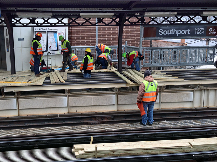
How many people does it take to re-deck a platform? (12 if you count the other 3 just out of frame) I am not a carpenter, but it seems like it would be hard to do anything very efficiently with that many people in such a small area.
 |
Anyone who wants to get weekly and 3-day passes before the price hike better get them now. Places all over are running out. I got the last of the 3-day passes at Walgreens. Don't know how fast businesses will keep up with restocking before Jan 14
|
Quote:
|
Quote:
I don't think any swing bridges are still operable anywhere in the Chicago area, except the one just south of Armitage on the North Branch. |
Quote:
|
The new Red Line stations have concrete platforms, because the embankment could bear the weight. The Brown Line stations would have needed costly strengthening work on the steel structure to install concrete. They did this at Morgan but that was expensive.
|
Quote:
So I take it the rail swing bridge at kedzie no longer works. |
Yes, the Amtrak bridge (my personal favorite) is lifted several times a day in summer. It's even lower than the Eight-Track because they didn't want grades on the approach to Union Station, so it has to be lifted even for large cabin cruisers and gravel barges. It was designed to someday be set to a higher grade (and to have a twin), but that never happened.
|
Preferred Design for the Circle Interchange
Aesthetic and Landscape treatments have yet to be decided, but the initial concepts are pretty fussy and not very promising. This is the stuff they should be considering. There's also a concept to triple the width of the Peoria bridge to make a proper landscape connection between UIC and the West Loop, with a signature CTA headhouse. http://farm9.staticflickr.com/8095/8...aefbdfb5_b.jpg |
2nd Congressional District Candidates Debate
Please attend if you can the 2nd Congressional District Candidates Debate:
Wednesday January 30, 2013 4:30pm to 9:00pm Rich Central High School 3600 203rd St. Olympia Fields, IL 60461 http://www.facebook.com/events/487324314642723/?ref=22 I will be there to submit ideas for Jobs, and Economic Development, and to distribute CTA Gray Line information and literature; there may also be coverage by Fox32 TV: http://www.myfoxchicago.com/story/17...-electric-line Mike Payne |
Quote:
|
Quote:
|
Quote:
can: http://www.activetrans.org/TransitSummit2013 |
Quote:
|
Streetsblog Chicago has an article on the first BRT meetings. Highlights:
Quote:
Quote:
|
CREATE Update
CREATE Project Status Maps have been updated as of Jan 18,2013
What is noticeable is the number of completed projects and also Phase III -Under Construction projects. The map does indicate that the P1 - Englewood flyover is in the construction phase. Below is another article on CREATE in Progressive Railroading Mag. CREATE update: Grade crossing upgrades, separations and closures Communication and Signal By Walter Weart For freight and passenger railroads, making the safety grade at crossings requires a little technology, a lot of partnering, more education and more closures. In the Chicago metropolitan area, railroads and a host of partners are working in a big way to improve crossing safety (see "Grade crossing safety: Freight and passenger railroads take a multi-pronged approach"). The $3.2 billion Chicago Region Environmental and Transportation Efficiency (CREATE) program, which started in 2003, includes crossing upgrades, grade separations (25 in all) and closures. Two recently completed projects include the $60 million Belmont Road grade separation in Downers Grove, Ill., which eliminated an intersection between the four-lane road and three BNSF Railway Co. tracks used by 150 Amtrak, Metra and BNSF trains daily; and the $165 million 115th & Torrence rail bridge replacement grade separation of the intersection of 130th Street and Torrence Avenue, says Jeff Sriver, CREATE project manager for the Chicago Department of Transportation. .... The goal of the 130th and Torrence grade separation project is to eliminate at-grade crossings on two Norfolk Southern Railway mainlines by lowering the profile of 130th Street and Torrence Avenue to fit under two new bridges that will carry the tracks and also be used by the Chicago South Shore and South Bend Railroad. In addition, an existing bridge carrying two Northern Indiana Commuter Transportation District/South Shore Line commuter-rail tracks over the NS tracks and Torrence Avenue will be rebuilt on a new alignment immediately south of the current structure. The 394-foot-long bridge is the largest truss bridge ever built off site and moved into place fully assembled, CREATE officials say. The project is scheduled for an April 2015 completion. "Two other notable crossing projects involved the Ashland and Damon crossing, which experiences over 50,000 vehicles a day, and a BNSF crossing on Blue Island Avenue, which used a tub-type crossing," says CREATE Coordinating Planner Joe Alonzo. Speaking of BNSF: The Class I has about 50 tub crossings in the Chicago area, 10 of which were installed in 2012, a BNSF spokesperson says. BNSF officials believe tub crossings work well in areas where there is high vehicular traffic and low train speeds. Unlike conventional concrete panels that fit on top of ties, tub crossings don’t sit on ties. The rails are attached directly to the precast concrete modules, which eliminate the use of ties and ballast. CREATE officials note that there's been less of a need for maintenance with the tub crossings currently place. CREATE officials also plan to use variable message signs to alert drivers "when a particular Belt Railway crossing is blocked, which occurs frequently and creates significant delays," says Chicago DOT Deputy Director David Zavattero. The signs are designed to alert drivers that gates are down and for how long. The crossing, which is monitored on a Belt Railway Co. of Chicago line, is located at 55th Street, just west of 55th and Central, at the northwest corner of Midway Airport. The signs — which ultimately could be tied into the railroad's crossing control system to provide additional information — will be placed along the Stevenson Expressway and Cicero Avenue during the next 18 months. If they prove to be successful, the signs could be installed in other locations, Zavattero says. Walter Weart is a Denver-based free-lance writer. Email comments or questions to prograil@tradepress.com. |
Yeah, the bridge at 130th and Torrence is now linked into the South Shore line and the previous viaduct is being dismantled.
http://sphotos-c.ak.fbcdn.net/hphoto...73109706_n.jpg src |
Wow that's blue!
|
^ How about we do this for much more of our public infrastructure? Please? Not all, but occasionally?
Quote:
Edit - perusing web links reveals someone is suggesting this size was exceeded by a foreign project - a 640-foot truss for the Quebec Cantilever Bridge. Quote:
|
Facebook dramatically lowers the barriers to frequent updating, especially for non web-savvy people. I doubt CREATE has the budget to hire a dedicated web person; they probably use one of IDOT or CMAP's people - when they remember to make an update, get materials together, send the email, make a phone call, etc. With Facebook, literally anyone can make an update in a few seconds. Its's also interactive, so (for example) Walsh Construction could post a cool photo of the 130th/Torrence project, shot by a Walsh employee, to the CREATE page.
CTA and CDOT also post quite a bit of content to social media now; CTA in particular has always (historically) been meticulous about photographing capital improvements and now both old and new photos are posted on Flickr for all to see. |
Looks like CTA ridership was up again in 2012. 2.4% growth in ridership.
http://www.transitchicago.com/assets...ts/2012-12.pdf |
WBEZ is reporting that the "preferred" design for the Ashland/Western BRT is median lanes on Ashland, coupled with a lane reduction, between Archer and Milwaukee. Expansions to the north or south, and anything on Western, would need to wait until later.
As I suspected awhile ago, this is basically a Circle Line replacement, connecting core CTA lines circumferentially and forming an express link to the Illinois Medical Center. Since it's a short segment, I imagine CTA will reinstate the X9 and run it using the new busway. |
Quote:
It's a little worrisome that December was down but overall seems like good news. Dan Ryan ridership next year will obviously be decimated by the reconstruction, which will probably bull the system total numbers below 2012 even if they manage to track all the additional bus and shuttle riders, but hopefully by 2014 it will immediately exceed 2012 due to the must faster travel times. 2013 should have higher ridership on all the other lines, though. 2014 I expect to be a banner year. |
Quote:
|
I wouldn't expect a return of the X9. First, I think that was paid for with demonstration project money and I don't know that it ever served much of a purpose north or south of the proposed BRT corridor. Second, the median BRT will require special buses with offside doors, so it would be tricky to have equipment that runs in normal and BRT service.
|
Quote:
|
Quote:
|
Quote:
:wtf: |
Quote:
I am however, very excited that the center running BRT with full street parking seems to have won favor with the city. I only wonder how nasty traffic will be where Ashland transitions from 2 lanes to 1. |
Is WBEZ still claiming it? I recall reading it with an update saying that no decision’s been made yet (though it’s around what I’d expect).
There are buses which can board from either side—I believe Eugene’s EmX uses them. |
| All times are GMT. The time now is 11:44 AM. |
Powered by vBulletin® Version 3.8.7
Copyright ©2000 - 2024, vBulletin Solutions, Inc.
 Prev
Prev