HomeDiagramsDatabaseMapsForum About
     

Go Back   SkyscraperPage Forum > Photography Forums > Found City Photos

Reply

 
Thread Tools Display Modes
     
     
  #35501  
Old Posted Jun 13, 2016, 7:51 PM
ethereal_reality's Avatar
ethereal_reality ethereal_reality is offline
Registered User
 
Join Date: Feb 2008
Location: Lafayette/West Lafayette IN, Purdue U.
Posts: 16,352


I was hoping the vintage building was still standing, hidden behind this cheesy post-modern bank facade.


detail

Are we certain this isn't a renovation of the older building? (maybe I missed that post)
Reply With Quote
     
     
  #35502  
Old Posted Jun 13, 2016, 8:01 PM
ethereal_reality's Avatar
ethereal_reality ethereal_reality is offline
Registered User
 
Join Date: Feb 2008
Location: Lafayette/West Lafayette IN, Purdue U.
Posts: 16,352
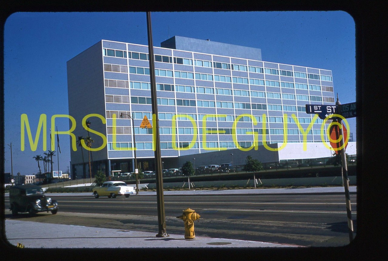
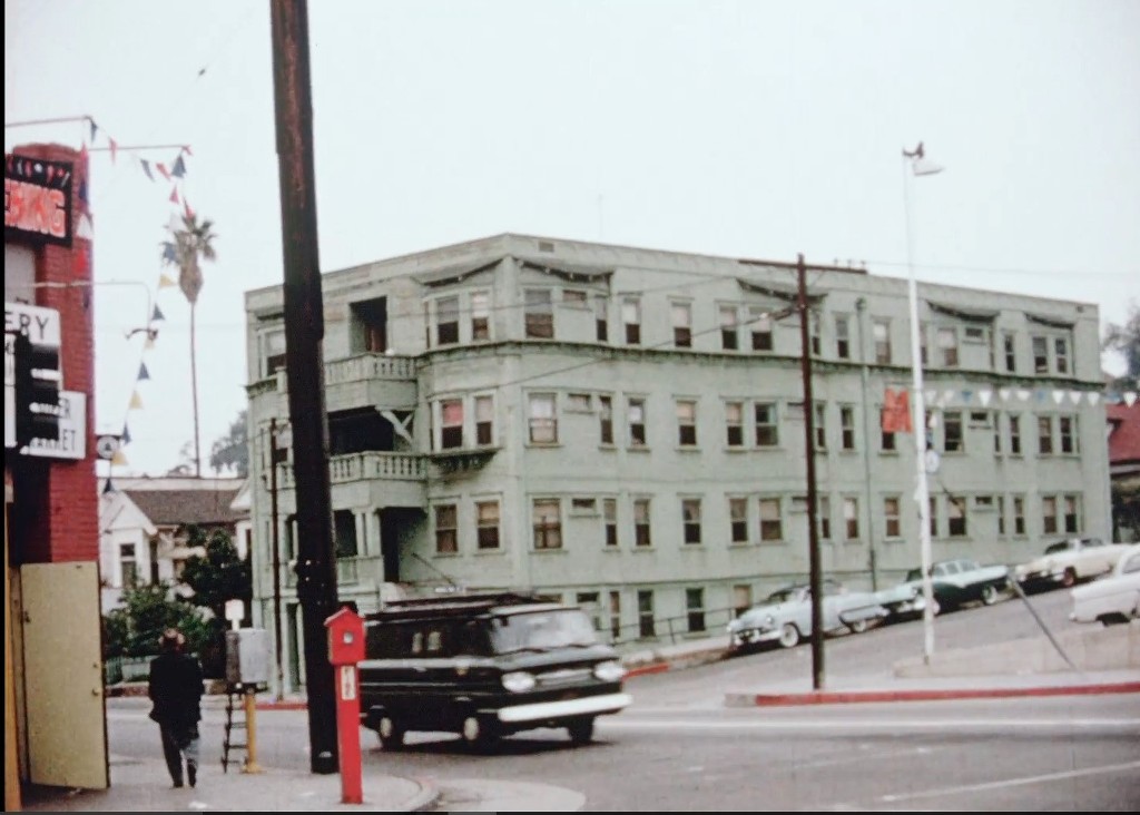
"1957 Original Slide Los Angeles Police Administration Building" (later the Parker Center)


eBay

Groundbreaking for the Center occurred on December 30, 1952, and construction was completed in 1955. The architect was Welton Becket.
The building combined police facilities that had been located throughout the Civic Center area. The location was previously home to the Olympic Hotel.

The building was a state of the art facility, and the envy of other police departments across the nation. So great was the demand for public tours that the Department
assigned policewomen full-time for the first year to give tours several times a day.

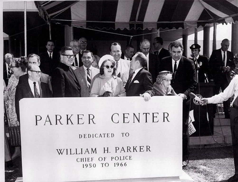
It was later renamed in honor of Chief William H. Parker, who died in office on July 16, 1966 from a heart attack. Chief since 1950, he helped establish the LAPD’s reputation
as a world leader in law enforcement."

The building was closed in 2013.

https://jesswaid.com/tag/los-angeles/


https://jesswaid.files.wordpress.com/2013/01/15webb.jpg

I spy a familiar face

_
Reply With Quote
     
     
  #35503  
Old Posted Jun 13, 2016, 9:16 PM
HossC's Avatar
HossC HossC is online now
Registered User
 
Join Date: Aug 2013
Posts: 4,245
Quote:
Originally Posted by Beaudry View Post

Hey all, has it been mentioned that USC is digitizing the City Archives, including films? Go here http://digitallibrary.usc.edu/cdm/la...n/p15799coll88 and take a look.

I mean, the first thing they show in this movie from the CRA is color film footage of the Rochester, and it just gets more insane from there. The largely undocumented Temple-Beaudry area sure gives Bunker Hill a run for its money.
I've only just had a chance to watch this film (spurred on by the posts of westcork, Tetsu and GaylordWilshire earlier today). I love these stairs, although I'm glad I don't live at the top! There's even a closer look just afterwards.


USC Digital Library

So much of this area has been wiped out, but we have a couple of survivors at Toluca and Colton Streets. NB. This is a combination of four screengrabs.


USC Digital Library

Here they are today.


GSV

The lot opposite the buildings above was empty in 1963, and still is.


USC Digital Library

The house next to the empty lot, however, appears to be another survivor.


GSV
Reply With Quote
     
     
  #35504  
Old Posted Jun 13, 2016, 9:37 PM
Earl Boebert Earl Boebert is offline
Registered User
 
Join Date: Mar 2012
Posts: 634
Quote:
Originally Posted by HossC View Post
As I said in my last Julius Shulman post a week ago, LA subjects are getting harder to find at the moment, so I'll only be posting them as and when I find them. Hopefully there'll be more as I continue through the search results. This is "Job 5430: Sylvan Shulman, West Covina Fashion Plaza (West Covina, Calif.), 1977". Sylvan Shulman is the architect. I had a quick look for more information to see if Julius and Sylvan were related, but didn't find anything.

[Snip]

The mall is now known as Plaza West Covina, and The Broadway store is now Sears. I can't find any good large images of the two-story section of the mall, so here's a small one.


[Snip]
Brings back memories. Spent a lot of time at the Honeywell plant at San Bernadino Rd and Grand. Would swing by the mall on the way to LAX to bring my wife some California fashion to show off in staid Minneapolis. That was back in the 70's, when there was still such a thing a local markets. Now everything is available everywhere.

Cheers,

Earl
Reply With Quote
     
     
  #35505  
Old Posted Jun 13, 2016, 10:17 PM
ethereal_reality's Avatar
ethereal_reality ethereal_reality is offline
Registered User
 
Join Date: Feb 2008
Location: Lafayette/West Lafayette IN, Purdue U.
Posts: 16,352
Quote:
Originally Posted by HossC View Post
I've only just had a chance to watch this film (spurred on by the posts of westcork, Tetsu and GaylordWilshire earlier today)
Me too, I just downloaded the amazing video this afternoon. (thanks for the link Beaudry!)

Have we talked about this large greenish apartment building on NLA? It looks familiar, but i can't recall the name.


the camera pans right and shows this next door neighbor.


and later in the video, we see the same apartment from a different angle.


Abie's Place would be just ahead and on the left.

I believe that's the Dept. of Water & Power bldg. under construction at upper right.


So is this the apartment building? (circled below)


W & P http://waterandpower.org/museum/Earl...+)_8_of_8.html

Last edited by ethereal_reality; Jun 13, 2016 at 10:27 PM.
Reply With Quote
     
     
  #35506  
Old Posted Jun 13, 2016, 11:23 PM
GaylordWilshire's Avatar
GaylordWilshire GaylordWilshire is offline
Registered User
 
Join Date: Nov 2009
Location: NYC
Posts: 3,703
Quote:
Originally Posted by Flyingwedge View Post
This was the home of George Drake Ruddy and his wife Ella:

1900 LACD @ fold3.com

The house was built in 1899 and either torn down or moved in 1912. GW has some details here.
The April 17, 1912, LA Herald notes that the Ruddys had taken apartments at the Hershey Arms
on Wilshire Boulevard. The November 20, 1912, Herald shows Mrs. Ruddy had contracted to build
a new home at 241 N. Western, where the 1913 LACD shows the Ruddys residing.

Here is the heretofore pictorially obscure "Mission Cottage" at 2711 Wilshire Blvd., probably with
Mr. and Mrs. Ruddy standing at the front door:

July 5, 1902, The Capital @ Google Books

By the way, at least half of the photos in the editions of The Capital (1897-1902) are of theatrical
performers who were on tour and stopping in LA. So if anyone is interested in actors, singers, and
other acts from that era, The Capital might be a good place to look.

GSV


The Ruddys' "Mission cottage" was bought by Hugh Bryson in late 1911 to be replaced by his fabled eponymous apartments; Bryson sold the house to a haberdasher who moved it to 222 South Gramercy Place by the next summer. It's still there, and, as you can see, looking very good.


My story on the house is here: http://wilshireboulevardhouses.blogs...e-see-our.html
Reply With Quote
     
     
  #35507  
Old Posted Jun 13, 2016, 11:24 PM
ethereal_reality's Avatar
ethereal_reality ethereal_reality is offline
Registered User
 
Join Date: Feb 2008
Location: Lafayette/West Lafayette IN, Purdue U.
Posts: 16,352
Since the Chapman Park Hotel is one of out favorite places to visit on NLA, I thought I'd give you a heads up on this skeleton* key that's currently on eBay.


http://www.ebay.com/itm/Collectible-...kAAOSwnNBXTxFo

So how do you tell when a key is a skeleton key.....(isn't 330 the room number?)

*the seller is the one that says this is a skeleton key.
_
Reply With Quote
     
     
  #35508  
Old Posted Jun 13, 2016, 11:31 PM
odinthor's Avatar
odinthor odinthor is offline
Registered User
 
Join Date: May 2015
Posts: 1,323
Quote:
Originally Posted by HossC View Post

[...snippage..]

The lot opposite the buildings above was empty in 1963, and still is.


USC Digital Library

The house next to the empty lot, however, appears to be another survivor.


GSV
Do I see the remnants of some sort of foundation or paving in the vacant lot? Perhaps someone once upon a time had a cozy little cottage on that nice corner lot!
Reply With Quote
     
     
  #35509  
Old Posted Jun 13, 2016, 11:42 PM
HossC's Avatar
HossC HossC is online now
Registered User
 
Join Date: Aug 2013
Posts: 4,245
Quote:
Originally Posted by ethereal_reality View Post

Have we talked about this large greenish apartment building on NLA? It looks familiar, but i can't recall the name.

That's the Northwest Apartments at 327 North Beaudry Avenue that we discussed in April. Wig-Wag posted the picture below and I posted the building permits and a "now" photo here.

Quote:
Originally Posted by Wig-Wag View Post

While going through my slide files this afternoon I came across this image from May, 1972. For a brief moment I though I had found a color photo of the building shown in odinthor's post below.

I quickly realized it was not the same building but also noticed that it has many of the architectural details of the building in the vintage photo. Is it possible the two buildings share the same designer/builder?

The property at the corner of Beaudry Avenue and Angelina Streets is now owned by the Edward R. Roybal Learning Center and the building is long gone.

Strangely, it looks like Abie's Place survives.


GSV
Reply With Quote
     
     
  #35510  
Old Posted Jun 13, 2016, 11:49 PM
HossC's Avatar
HossC HossC is online now
Registered User
 
Join Date: Aug 2013
Posts: 4,245
Following on from my Julius Shulman Plaza West Covina post, here is how the mall evolved. The first aerial view shows the area as fields in 1952.


Historic Aerials

The first stores were in an L-shape set at 45 degrees, roughly following the lines of the fields. This image is from 1964.


Historic Aerials

The Wikipedia entry for Plaza West Covina says "West Covina Plaza, an open-air strip shopping complex, opened in 1962, anchored by The Broadway and Desmond's, a specialty retailer." However, the picture below is dated by its source as 1958.


westcovinalapuentebaldwinpark.blogspot.com

The same site also has this ground level shot just dated as 1950s. Is that a searchlight on the right?


westcovinalapuentebaldwinpark.blogspot.com/Clifford O'Brien

Returning to the Wikipedia page, "The complex [above] was demolished in 1974, leaving The Broadway and Desmond's intact. These were worked into an enclosed complex known as West Covina Fashion Plaza, which opened in 1975." This 1980 view shows the eastern arm of the original mall standing beside the new building.


Historic Aerials

The eastern section was eventually replaced - "In 1991, the official name of the shopping venue was changed to Plaza At West Covina. 1992-1993, a new wing anchored by Robinsons-May was constructed east of the Bullock's store." The 1995 image below is very close to the current layout.


Historic Aerials
Reply With Quote
     
     
  #35511  
Old Posted Jun 14, 2016, 3:40 AM
Flyingwedge's Avatar
Flyingwedge Flyingwedge is offline
Registered User
 
Join Date: Jun 2012
Location: Los Angeles
Posts: 1,127
Quote:
Originally Posted by ethereal_reality View Post
I don't recall seeing this sightseeing platform


Observation telescopes overlooking Los Angeles Harbor, San Pedro CA.


eBay

sign: "Telescopes, see Ships....Cruisers....Mountains'

Any idea where this would have been located? I believe that might be a rail in the payment.

__
That's an interesting photo of Lookout Point Park, e_r. It looks like the writing on the image gives an address of 3500 Gaffey Street.
On the map below, the little stubby street just east of Lookout Point Park is 35th Street:


Googlemap

I think the vintage photo shows a seam in the concrete rather than a rail, but the base for the old observation platform is still there,
as is the fine view of LA Harbor:

Feb 2015 GSV

# # #

P.S. Great job finding where 2711 Wilshire ended up, GW!

Last edited by Flyingwedge; Jun 14, 2016 at 6:51 AM. Reason: east not west
Reply With Quote
     
     
  #35512  
Old Posted Jun 14, 2016, 1:30 PM
HossC's Avatar
HossC HossC is online now
Registered User
 
Join Date: Aug 2013
Posts: 4,245
Quote:
Originally Posted by ethereal_reality View Post

I was hoping the vintage building was still standing, hidden behind this cheesy post-modern bank facade.


detail

Are we certain this isn't a renovation of the older building? (maybe I missed that post)
The only building permit I can find for 8901 Santa Monica Boulevard is from 1940. I've also looked at Historic Aerials, and the current building appears to have exactly the same footprint as in older views. Maybe it was just an extreme makeover.


------------------------


Quote:
Originally Posted by HossC View Post

So much of this area has been wiped out, but we have a couple of survivors at Toluca and Colton Streets. NB. This is a combination of four screengrabs.


USC Digital Library

Here they are today.


GSV
After revisiting this location with both Historic Aerials and the online building records, it appears that these apartments were only built in 1955 (eight years before the USC film). Still, they've now stood for over 60 years!


------------------------


Quote:
Originally Posted by odinthor View Post

Do I see the remnants of some sort of foundation or paving in the vacant lot? Perhaps someone once upon a time had a cozy little cottage on that nice corner lot!
I've checked the images at Historic Aerials back to 1948 and the Baist maps, and I can't see a stucture on that lot at any time. Of course, there could've been one there at other times.

Here's a reminder of the empty lot I'm talking about.


GSV
Reply With Quote
     
     
  #35513  
Old Posted Jun 14, 2016, 3:56 PM
oldstuff oldstuff is offline
Registered User
 
Join Date: Aug 2012
Posts: 623
Quote:
Originally Posted by HossC View Post
That's the Northwest Apartments at 327 North Beaudry Avenue that we discussed in April. Wig-Wag posted the picture below and I posted the building permits and a "now" photo here.


Strangely, it looks like Abie's Place survives.


GSV
The Pupusa place that is seen in this picture, has gone out of business in the last two months ( I drive by it every day).
Reply With Quote
     
     
  #35514  
Old Posted Jun 14, 2016, 4:07 PM
ethereal_reality's Avatar
ethereal_reality ethereal_reality is offline
Registered User
 
Join Date: Feb 2008
Location: Lafayette/West Lafayette IN, Purdue U.
Posts: 16,352
Originally posted by Flyingwedge

Thanks for this FW.

Kinda' fun that the circular platform is still there.


I had to take a look for myself and found a similar circular area.


google_aerial


I had to snicker when I saw this tiny little viewing platform raised about 2 feet.


gsv


Then I noticed the round metal area is the same as the one in the middle of the old telescope platform.


gsv

Now I'm thinking these might be old gun mounts.
Does anyone know, were there ever guns at this overlook area?
__


*I just found this 1937 aerial that shows the area in question. (just above the word 'Merriam)


http://www.fortwiki.com/Fort_MacArthur


close-up


...but it doesn't give me any answers.

In fact it leads to more questions. In this view there are six objects. Are these cars...or something else?

__

Last edited by ethereal_reality; Jun 14, 2016 at 4:38 PM.
Reply With Quote
     
     
  #35515  
Old Posted Jun 14, 2016, 4:13 PM
odinthor's Avatar
odinthor odinthor is offline
Registered User
 
Join Date: May 2015
Posts: 1,323
Quote:
Originally Posted by HossC View Post
The only building permit I can find for 8901 Santa Monica Boulevard is from 1940. I've also looked at Historic Aerials, and the current building appears to have exactly the same footprint as in older views. Maybe it was just an extreme makeover.


------------------------


After revisiting this location with both Historic Aerials and the online building records, it appears that these apartments were only built in 1955 (eight years before the USC film). Still, they've now stood for over 60 years!


------------------------


I've checked the images at Historic Aerials back to 1948 and the Baist maps, and I can't see a stucture on that lot at any time. Of course, there could've been one there at other times.

Here's a reminder of the empty lot I'm talking about.


GSV
Thanks for checking, HossC!

Nothing there in 1909 either:


Library of Congress Panoramic Maps Collection https://www.loc.gov/resource/g4364l.pm000290/
Reply With Quote
     
     
  #35516  
Old Posted Jun 14, 2016, 4:28 PM
ethereal_reality's Avatar
ethereal_reality ethereal_reality is offline
Registered User
 
Join Date: Feb 2008
Location: Lafayette/West Lafayette IN, Purdue U.
Posts: 16,352
...while we're in the San Pedro/Point Fermin area


Just south of the Gaffey Street overlook area is this fine looking apartment building.


gsv


It also appears in the 1937 aerial.


Here's a couple more views (this is the corner of Gaffey and 36th Street)


along Gaffey street.


detail


I know there's a name for the elaborate window on the left but it escapes my mind at the moment.

I don't know if the 'grapevine' window is original to the building. (it's rather interesting none-the-less)
_

Last edited by ethereal_reality; Jun 14, 2016 at 4:42 PM.
Reply With Quote
     
     
  #35517  
Old Posted Jun 14, 2016, 4:29 PM
oldstuff oldstuff is offline
Registered User
 
Join Date: Aug 2012
Posts: 623
Quote:
Originally Posted by Flyingwedge View Post
That's an interesting photo of Lookout Point Park, e_r. It looks like the writing on the image gives an address of 3500 Gaffey Street.
On the map below, the little stubby street just east of Lookout Point Park is 35th Street:


Googlemap

I think the vintage photo shows a seam in the concrete rather than a rail, but the base for the old observation platform is still there,
as is the fine view of LA Harbor:

Feb 2015 GSV

# # #

P.S. Great job finding where 2711 Wilshire ended up, GW!
The area is called the "Gaffey Bulge" and it was right below where there was a gun battery on the hill to the north. In the current photo you can see the rounded metal plate that sticks up above the concrete. This was a mount for an anti-aircraft, and an anti- torpedo boat gun which was part of the harbor defenses of the Upper Reservation of Fort MacArthur. It was a WWII vintage 90 MM gun. There is a rectangular metal plate just in front of the round mount which is a manhole access door to the underground support rooms below.

The whole hill in that area above the Point Firmin Lighthouse is honeycombed with tunnels, storage rooms and other defense structures from Fort MacArthur. Batteries Merriam and Leary were on the hill directly above the bulge as seen in the aerials above. Batteries Osgood and Farley are restored and there is a very interesting museum there.

Prior to that, there was probably another type of gun mounted there since Fort MacArthur had been an active army post since the Spanish American War

Last edited by oldstuff; Jun 14, 2016 at 5:03 PM.
Reply With Quote
     
     
  #35518  
Old Posted Jun 14, 2016, 4:38 PM
ethereal_reality's Avatar
ethereal_reality ethereal_reality is offline
Registered User
 
Join Date: Feb 2008
Location: Lafayette/West Lafayette IN, Purdue U.
Posts: 16,352
Thank you oldstuff! You answered my question to a T.

...which makes this all the more intriguing.


eBay

I don't know the make of cars very well, but I'd guess this photo dates to the 1930s.
So were the guns removed between the World Wars? Were they re-installed during WWII?
Reply With Quote
     
     
  #35519  
Old Posted Jun 14, 2016, 7:32 PM
Martin Pal Martin Pal is online now
Registered User
 
Join Date: Sep 2013
Posts: 2,453


Quote:
Originally Posted by ethereal_reality View Post
Now I'm thinking these might be old gun mounts.
Does anyone know, were there ever guns at this overlook area?
__

*I just found this 1937 aerial that shows the area in question. (just above the word 'Merriam)

...but it doesn't give me any answers.

In fact it leads to more questions. In this view there are six objects. Are these cars...or something else?
__
When I did a post about Fort MacArthur [HERE] I included a link that has information about the Battery Leary - Merriam area, and the other areas on that photograph as well. This whole area has been used for different purposes over the decades and also changed, in part, too (for example, part of the area was filled in), so it's hard to answer some of the questions "simply", because you can't always compare the now and then photographs as being the same thing, if that makes sense.

Here's the link to the Merriam location in particular, but you can navigate from there all around the area for other information.

http://www.ftmac.org/Leary-Merriam.htm
Reply With Quote
     
     
  #35520  
Old Posted Jun 14, 2016, 7:41 PM
HossC's Avatar
HossC HossC is online now
Registered User
 
Join Date: Aug 2013
Posts: 4,245
This Julius Shulman photo is a complete mystery. There's no location or date, and there aren't even any vehicles to help out. We've seen another Robert's Drive-In a few times on NLA, but this one uses a different style of lettering. It might not even have been in Los Angeles. Anyway, it's "Job R-1: Roberts Drive-In, 19??".


Maybe someone remembers "La Cantina" cocktail bar on the left.


Getty Research Institute
Reply With Quote
     
     
This discussion thread continues

Use the page links to the lower-right to go to the next page for additional posts

Reply

Go Back   SkyscraperPage Forum > Photography Forums > Found City Photos
Forum Jump


Forum Jump


All times are GMT. The time now is 8:19 PM.

     
SkyscraperPage.com - Archive - Privacy Statement - Top

Powered by vBulletin® Version 3.8.7
Copyright ©2000 - 2024, vBulletin Solutions, Inc.