HomeDiagramsDatabaseMapsForum About
     

Go Back   SkyscraperPage Forum > Regional Sections > Canada > Ontario > Ottawa-Gatineau > Urban, Urban Design & Heritage Issues


Reply

 
Thread Tools Display Modes
     
     
  #81  
Old Posted Nov 14, 2013, 12:22 AM
waterloowarrior's Avatar
waterloowarrior waterloowarrior is offline
National Capital Region
 
Join Date: Nov 2005
Location: Eastern Ontario
Posts: 9,244
Reply With Quote
     
     
  #82  
Old Posted Dec 4, 2013, 5:27 AM
waterloowarrior's Avatar
waterloowarrior waterloowarrior is offline
National Capital Region
 
Join Date: Nov 2005
Location: Eastern Ontario
Posts: 9,244
Lees/Hurdman/Blair TOD plans going to Planning Committee
http://app05.ottawa.ca/sirepub/mtgvi...&itemid=312863

Same with Scott Street CDP
http://app05.ottawa.ca/sirepub/mtgvi...&itemid=301023
Reply With Quote
     
     
  #83  
Old Posted Jan 23, 2014, 12:24 AM
rocketphish's Avatar
rocketphish rocketphish is offline
Planet Ottawa and beyond
 
Join Date: Feb 2009
Location: Ottawa
Posts: 12,292
Council approves new vision for Scott Street community

By Derek Spalding, OTTAWA CITIZEN January 22, 2014 7:03 PM


OTTAWA — A plan for the future development of neighbourhoods straddling Scott Street near Tunney’s Pasture were approved by city council Wednesday.

The Scott Street community design plan outlines a vision for taller buildings, increased density and more mixed use centres. Created over the past year, largely by Toronto design firm Urban Strategies, the CDP proposes making Scott a more pedestrian-and bike-friendly complete street, while other major roads such as Parkdale and Holland will have more flexible zoning designed to encourage more mixed-use developments.

Tall buildings will be concentrated in a new mixed-use centre located south of Scott Street between Holland and Parkdale Avenues. The centre is strategically located near transit networks and is a city target for intensification.

Design plans extend to several neighbourhoods, including Tunney’s Pasture, Mechanicsville, parts of Hintonburg and Wellington Village and Champlain Park.

© Copyright (c) The Ottawa Citizen

http://www.ottawacitizen.com/news/ot...485/story.html
Reply With Quote
     
     
  #84  
Old Posted Feb 6, 2014, 1:13 AM
waterloowarrior's Avatar
waterloowarrior waterloowarrior is offline
National Capital Region
 
Join Date: Nov 2005
Location: Eastern Ontario
Posts: 9,244
some more meetings... Kanata North Feb 26
http://ottawa.ca/en/city-hall/public...bruary-26-2014

Preston-Carling Feb 25
http://ottawa.ca/en/city-hall/public...mation-session

If you live in the area and are interested it's important to go as these secondary plans will have more teeth under the new OP.
Reply With Quote
     
     
  #85  
Old Posted Feb 16, 2014, 10:38 PM
citydwlr citydwlr is offline
Registered User
 
Join Date: Mar 2013
Posts: 725
Westside Action has an interesting series of articles regarding the upcoming Preston-Gladstone CDP (being issued Tuesday, Feb. 18, 2014 apparently):

Gladstone CDP (part i): Ashcroft Canyon … a prototype?

Gladstone CDP (part ii): City Proposes Second High Rise Cluster on Preston

Gladstone CDP (part iii) : dealing with BLISS
Reply With Quote
     
     
  #86  
Old Posted Feb 19, 2014, 12:34 AM
waterloowarrior's Avatar
waterloowarrior waterloowarrior is offline
National Capital Region
 
Join Date: Nov 2005
Location: Eastern Ontario
Posts: 9,244
Reply With Quote
     
     
  #87  
Old Posted Mar 25, 2014, 11:39 PM
waterloowarrior's Avatar
waterloowarrior waterloowarrior is offline
National Capital Region
 
Join Date: Nov 2005
Location: Eastern Ontario
Posts: 9,244
Motion coming to Council tomorrow to fund an update of the Sandy Hill Secondary Plan
Reply With Quote
     
     
  #88  
Old Posted Mar 27, 2014, 2:10 AM
rocketphish's Avatar
rocketphish rocketphish is offline
Planet Ottawa and beyond
 
Join Date: Feb 2009
Location: Ottawa
Posts: 12,292
Open house draws protest agents review of city’s Uptown Rideau plan

By Megan Delaire, OTTAWA CITIZEN March 26, 2014 9:17 PM


OTTAWA — Dozens of residents gathered Wednesday outside an open house at the Rideau Library to protest the city’s decision to review the area’s existing community design plan.

The current Uptown Rideau Community Design Plan has been in place since 2005. It covers Rideau Street from King Edward Avenue to the Cummings Bridge and sets regulations, based on public consultations, for land use, building height, size and design, and traffic management.

The city’s planning committee sought advice from area residents, developers and business owners for the drafting of the original plan. However, residents feel that the city’s decision to amend the plan contradicts the public deliberation process.

“This plan has been worked out in consultation, but as soon as a developer that seems to own this city wants changes, they don’t ask for small changes,” said protester Jacqueline Hucker, who is a heritage consultant and architectural historian.

“We’re supposed to be a democracy. We’re not supposed to be run by developers.”

The city’s decision to review the plan comes as developers Richcraft Homes and Codeau Building Ltd. are seeking zoning approval to construct 18- and 16-storey condominium buildings respectively at 560 and 541-545 Rideau St.

The Sandy Hill Secondary Plan is a legally binding contract covering the south side of Rideau Street between King Edward Avenue and the Cummings Bridge that states, in conjunction with the existing community design plan, that limits buildings to no more than six storeys.

In Ontario, land owners may submit zoning amendment applications to build beyond zoning bylaw restrictions, which is what developers in the area are doing.

Melanie Knight, a planner with Ottawa Community Planning and Urban Design who is revisiting the Uptown Rideau Community Design Plan, said the community design plan is a separate entity from that which approves zoning applications. However, she said development applications, among other factors such as the Rideau Street Renewal, have influenced the city’s decision to re-evaluate the design plan.

“The biggest thing for this update is that because we’ve seen some attention with development applications and because Rideau Street has just been redone and everything has been upgraded, we want to go through the process of updating the CDP to make sure that it’s comprehensive like the ones we’ve done in previous years,” Knight said.

As it did with the original drafting of the community development plan, Knights said, the city intends to consult community organizations, residents and Ottawa Public Housing.

mdelaire@ottawacitizen.com
twitter.com/MeganDeLaire

© Copyright (c) The Ottawa Citizen

http://www.ottawacitizen.com/news/Op...880/story.html
Reply With Quote
     
     
  #89  
Old Posted Mar 27, 2014, 2:50 AM
waterloowarrior's Avatar
waterloowarrior waterloowarrior is offline
National Capital Region
 
Join Date: Nov 2005
Location: Eastern Ontario
Posts: 9,244
here's the Uptown Rideau city page
http://ottawa.ca/en/city-hall/public...ty-design-plan
Reply With Quote
     
     
  #90  
Old Posted Apr 4, 2014, 2:23 AM
waterloowarrior's Avatar
waterloowarrior waterloowarrior is offline
National Capital Region
 
Join Date: Nov 2005
Location: Eastern Ontario
Posts: 9,244
2014 Manotick Secondary Plan Update
http://ottwatch.ca/consultations/160

East Urban Community Mixed Use Centre Community Design Plan
http://ottawa.ca/en/city-hall/public...xed-use-centre

South Keys to Blossom Park, Bank Street Community Design Plan
http://ottawa.ca/en/city-hall/public...ty-design-plan
Reply With Quote
     
     
  #91  
Old Posted Jun 17, 2014, 9:45 PM
waterloowarrior's Avatar
waterloowarrior waterloowarrior is offline
National Capital Region
 
Join Date: Nov 2005
Location: Eastern Ontario
Posts: 9,244
Preston-Carling Secondary Plan on Planning Committee agenda
http://app05.ottawa.ca/sirepub/agdoc...&itemid=317687
Reply With Quote
     
     
  #92  
Old Posted Jun 24, 2014, 4:36 PM
waterloowarrior's Avatar
waterloowarrior waterloowarrior is offline
National Capital Region
 
Join Date: Nov 2005
Location: Eastern Ontario
Posts: 9,244
Major criticism of the Preston-Carling process from Eric Darwin
http://www.westsideaction.com/supping-poisoned-chalice/

This is at PEC right now...lots of debate
Reply With Quote
     
     
  #93  
Old Posted Feb 27, 2015, 11:00 PM
waterloowarrior's Avatar
waterloowarrior waterloowarrior is offline
National Capital Region
 
Join Date: Nov 2005
Location: Eastern Ontario
Posts: 9,244
Draft Gladstone Station District CDP
http://ottawa.ca/en/city-hall/public...-amendment-and
Reply With Quote
     
     
  #94  
Old Posted Feb 28, 2015, 3:33 AM
Urbanarchit Urbanarchit is offline
Registered User
 
Join Date: Jun 2013
Location: Ottawa
Posts: 1,910
Quote:
Originally Posted by waterloowarrior View Post
Draft Gladstone Station District CDP
http://ottawa.ca/en/city-hall/public...-amendment-and
I'm looking through this now, but I'm interpreting the plan to have Adult High School demolished and have the site redeveloped? I hope not because it's a great example of Modernism (reminds me of Oscar Niemeyer's work). Would be a shame to see it eliminated.

It needs renovation, but maybe keep the three top buildings on Rochester, and then creating a new podium that extends to Preston and has new buildings on that?
Reply With Quote
     
     
  #95  
Old Posted Jul 28, 2015, 12:09 PM
waterloowarrior's Avatar
waterloowarrior waterloowarrior is offline
National Capital Region
 
Join Date: Nov 2005
Location: Eastern Ontario
Posts: 9,244
Hearing for Preston-Carling CDP's secondary plan starts Feb 2016
https://www.canlii.org/en/on/onomb/d...nlii43651.html
Reply With Quote
     
     
  #96  
Old Posted Sep 10, 2015, 5:17 PM
rocketphish's Avatar
rocketphish rocketphish is offline
Planet Ottawa and beyond
 
Join Date: Feb 2009
Location: Ottawa
Posts: 12,292
South Keys design plan bringing big change to transit hub
Box stores to transform into Main Street plaza

By Emma Jackson
Ottawa South News, Sep 08, 2015


It’s the kind of grand revisioning that progressive urban planners can usually only dream: taking a car-centric box store mall and turning it into a walkable, attractive place to shop and live, complete with urban parkettes, green space and rapid transit right next door.

That’s exactly what the city has in mind for the South Keys shopping plaza near Bank Street and Hunt Club Road, which has anything but a main street feel right now. The mall, owned largely by Smart Centres box store plaza developer, is currently home to Chapters, Walmart, Loblaws, Winners, Michaels, a Cineplex movie theatre and several other major chains.

But the city’s planning committee approved on Sept. 8 a set of policy and design changes that will set in motion an “incremental” change to the centre, which would see it transform into a main street-style centre with less surface parking and more landscaped elements such as a town square and urban parks.

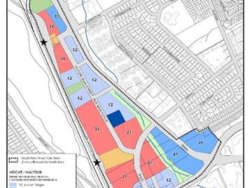
The transformation begins with adding new land uses, most notably urban residential, and increasing height limits to up to 21 storeys where the property is closest to rapid transit. That includes the existing Greenboro station, and the planned South Keys stop that will be added when the O-Train is extended to Riverside South by 2023.

Other areas of the property would allow between 12 and 15 stories, to help transition from the established low-rise communities south and east of the plaza.

The changes are part of a larger Bank Street community design plan for the area between South Keys and Blossom Park. The plan will focus future growth around the northern plaza, while slightly increasing heights along the rest of Bank Street to nine storeys instead of eight to comply with Official Plan guidelines. It also puts in place a more detailed plan for developing walking and cycling facilities throughout the region.

RAPID CHANGE

While the South Keys redevelopment idea was generally applauded around the committee table, there was a sense it didn’t go far enough to take advantage of what will someday become a major transit hub. Beacon Hill-Cyrville Coun. Tim Tierney felt the height limits should be increased to 21 storeys across the board in that section, instead of limiting it to 12 and 15 in some spots.

“I don’t see why we didn’t just … give that opportunity, because we don’t have a light rail system in everyone’s backyard,” Tierney said. “This is where we want (intensification).”

In fact, he and Kitchissippi Coun. Jeff Leiper both wanted to see heights approved above 21 storeys, similar to the city’s transit-oriented development plans for other light-rail hubs, which allow up to 30. But since the mall is on a flight path, the Ottawa International Airport Authority doesn’t allow buildings in the area to go above a certain elevation, city planner Chris Brouwer said.

Brouwer also noted that a “pyramid approach” to height limits is common even for the other transit-oriented developments plans; in this case the 12-storey allowances front largely onto Bank and Hunt Club where low-rise neighbourhoods are located across the street. The 15-storey buildings in the centre provide a transition to the high-rise residential towers they expect to see closer to transit.

He reminded the councillors that it’s still going to increase density by several times.

“We’ll have the minimum density of 200 people and jobs per hectare in this area … the existing density in this area is about 50,” Brouwer said. “So the minimum density moving forward will be four times what we see here today.”

River Coun. Riley Brockington, whose ward is just a train track away from the plaza, said he’s concerned residents will lose access to a major shopping centre – particularly cheap and accessible groceries – if the area is changed to encourage smaller, boutique-style shops.

“There is a large population in that South Keys area who have no other grocery store to go to,” he said.

Staff assured him the changes will simply add uses, not take away – although the design consultations done earlier in the process did prefer a series of smaller buildings rather than the large box stores that dominate the space right now.

Brockington was also worried about the impact on parking and traffic as density is increased – something staff didn’t seem too worried about, given their plans to focus the new mixed-use centre on increased walkability, cycling infrastructure and rapid transit.

“As it becomes less convenient to travel in that area by automobile, they’ll choose to walk or cycle because it’s faster and more attractive,” Brouwer said.

That won’t help shoppers coming in from Greely and other rural areas of the city to do their shopping, Kanata South Coun, Allan Hubley said.

Smart Centres could not be reached for comment, but Brouwer said representatives have been “around the table” since the CDP consultations began in 2013 – and they’re on board.

“They are talking about incremental change over time in this area, and they are in agreement for providing various urban design components as they redevelop,” he said. “At each phase they would add sidewalks, multi-use pathways, parks, open space. They seem to be invested in the idea.”

Despite the quibbles around the table, the community design plan was approved with dissent only from Hubley, who said he couldn’t see a big enough benefit to the community to justify spending thousands of staff hours on a “feel-good exercise.”

He said residents will now expect the new CDP to give them a certainty that can’t be guaranteed.

“That’s our fault for not being clear about what should be expected,” he said. “We have to be more upfront with residents that this is a feel-good exercise but don’t expect it to win at the Ontario Municipal Board.”

http://www.ottawacommunitynews.com/n...o-transit-hub/
Reply With Quote
     
     
  #97  
Old Posted Sep 10, 2015, 6:12 PM
MoreTrains MoreTrains is offline
Registered User
 
Join Date: Oct 2014
Posts: 858
So... will they make the Trillium line double tracked for something like this? Likely not. I find it interesting there are two, relativley large TOD areas on the Trillium line and the city still thinks it is sufficient as is.

But this sounds awesome, I hate this place as is, only good thing there in my opinion is Mucho Burrito. There is too much sprawling ashphalt, especially given it is within the greenbelt AND on the Transitway and soon to be on the Trillium line.
Reply With Quote
     
     
  #98  
Old Posted Sep 10, 2015, 9:53 PM
Proof Sheet Proof Sheet is offline
Registered User
 
Join Date: May 2009
Posts: 2,860
Quote:
Originally Posted by waterloowarrior View Post
Hearing for Preston-Carling CDP's secondary plan starts Feb 2016
https://www.canlii.org/en/on/onomb/d...nlii43651.html
And the City is soliciting fee proposals from planning consultants wanting to take on this file on behalf of the City Council position. As is standard for these types of assignments you are going against City Planning Staff recommendation.
Reply With Quote
     
     
  #99  
Old Posted Sep 15, 2015, 8:55 PM
Dr.Z Dr.Z is offline
From the Planning Paradox
 
Join Date: Mar 2011
Posts: 129
"River Coun. Riley Brockington, whose ward is just a train track away from the plaza, said he’s concerned residents will lose access to a major shopping centre – particularly cheap and accessible groceries – if the area is changed to encourage smaller, boutique-style shops.

"'There is a large population in that South Keys area who have no other grocery store to go to,' he said.

Uh, there's a Metro and Produce Depot kiddie corner from here, Giant Tiger and Farm Boy 2 km to the south, and IGA 2 km to the north and TNT 4 km to the west. Never mind that redevelopment here could also see a grocery store with residential and/or office above.
__________________
"What about the children?! Won't somebody please think of the children!?"
Reply With Quote
     
     
  #100  
Old Posted Sep 15, 2015, 9:11 PM
Norman Bates Norman Bates is offline
Living With My Mother
 
Join Date: Feb 2009
Posts: 985
Not being a jerk here - but trying to picture the IGA 2 km to the north.
Reply With Quote
     
     
This discussion thread continues

Use the page links to the lower-right to go to the next page for additional posts
 
 
Reply

Go Back   SkyscraperPage Forum > Regional Sections > Canada > Ontario > Ottawa-Gatineau > Urban, Urban Design & Heritage Issues
Forum Jump


Forum Jump


All times are GMT. The time now is 9:15 PM.

     
SkyscraperPage.com - Archive - Privacy Statement - Top

Powered by vBulletin® Version 3.8.7
Copyright ©2000 - 2024, vBulletin Solutions, Inc.