HomeDiagramsDatabaseMapsForum About
     

Go Back   SkyscraperPage Forum > Photography Forums > Found City Photos

Reply

 
Thread Tools Display Modes
     
     
  #14901  
Old Posted May 31, 2013, 12:59 AM
westcork westcork is offline
Registered User
 
Join Date: Jan 2011
Posts: 189
Quote:
Originally Posted by mdiederi View Post
Did a search and didn't find this one posted yet. Gerald Desmond Bridge 1967. (Construction has begun on the replacement bridge.)


http://www.newgdbridge.com/gallery/press_photos.asp
Odd timing. I was just looking at this drawing last night...

Rendering of the Gerald Desmond Bridge (span 5,134 ft.) located in the Port of Long Beach and connects the Ports of Long Beach and Los Angeles with the I-710. The bridge was built in 1968 as a third route onto Terminal Island to compliment Commodore Heim and Vincent Thomas Bridges, both part of California Highway 47. Gerald Desmond was a prominent Long Beach civic leader who served as a councilmember and City Attorney for the City of Long Beach.

LAPL
Reply With Quote
     
     
  #14902  
Old Posted May 31, 2013, 1:01 AM
CityBoyDoug CityBoyDoug is offline
BANNED
 
Join Date: Apr 2013
Posts: 2,868
A big new bridge for big ships.

Quote:
Originally Posted by mdiederi View Post
Did a search and didn't find this one posted yet. Gerald Desmond Bridge 1967. (Construction has begun on the replacement bridge.)


http://www.newgdbridge.com/gallery/press_photos.asp
Here is the new Billion Dollar bridge. It will be the cable-stayed type which is all the rage these days.


This is how you traveled from Long Beach to Terminal Island before there was a bridge. This was a floating two piece pontoon bridge. It was built during WW II and was slated to last a few months. It lasted for almost a quarter century. I rode over this bridge many times on my way to the base on T.I. Back in the day it was called "the milk run". I was stationed at Naval Station Long Beach in the late 1960s. That old Navy base is long gone and is now a Chinese container terminal.

Last edited by CityBoyDoug; May 31, 2013 at 2:25 AM.
Reply With Quote
     
     
  #14903  
Old Posted May 31, 2013, 1:28 AM
Noircitydame's Avatar
Noircitydame Noircitydame is offline
Registered User
 
Join Date: Nov 2010
Location: Outskirts of Noir City, California
Posts: 226
I came across these great images in the LAPL collection - I don't recall seeing them before, and I've looked tons of times. The description says "Policeman is shown holding the door for woman entering white car." A policeman?? It's Chief of Police Two-Gun Davis! Looks like they’re on First St. in front of City Hall across from the Natick? And the cars I believe are 1934 Ford V8s – but wonder who those dames are? Love the wet sidewalk/pavement -so noir.


http://jpg2.lapl.org/pics04/00011704.jpg
Reply With Quote
     
     
  #14904  
Old Posted May 31, 2013, 2:17 AM
CityBoyDoug CityBoyDoug is offline
BANNED
 
Join Date: Apr 2013
Posts: 2,868
"Vice"?

Quote:
Originally Posted by Noircitydame View Post
I came across these great images in the LAPL collection - I don't recall seeing them before, and I've looked tons of times. The description says "Policeman is shown holding the door for woman entering white car." A policeman?? It's Chief of Police Two-Gun Davis! Looks like they’re on First St. in front of City Hall across from the Natick? And the cars I believe are 1934 Ford V8s – but wonder who those dames are? Love the wet sidewalk/pavement -so noir.


http://jpg2.lapl.org/pics04/00011704.jpg
Not to be judgmental Noircitydame but those ladies do look a bit, shall we say "Red Light" . Super noir photos!!

Last edited by CityBoyDoug; May 31, 2013 at 4:02 AM.
Reply With Quote
     
     
  #14905  
Old Posted May 31, 2013, 5:11 AM
Flyingwedge's Avatar
Flyingwedge Flyingwedge is offline
Registered User
 
Join Date: Jun 2012
Location: Los Angeles
Posts: 1,127
Palm-photo-free Dr. William A. Hammel info

How is Dr. William A. Hammel, born in Germany, then a resident of Washington, D.C., later the builder of one of the first brick homes in Los Angeles on San Pedro Street in the mid-1850s -- which he surrounded with palm trees -- connected to the song "California, Here I Come"? Let me explain.

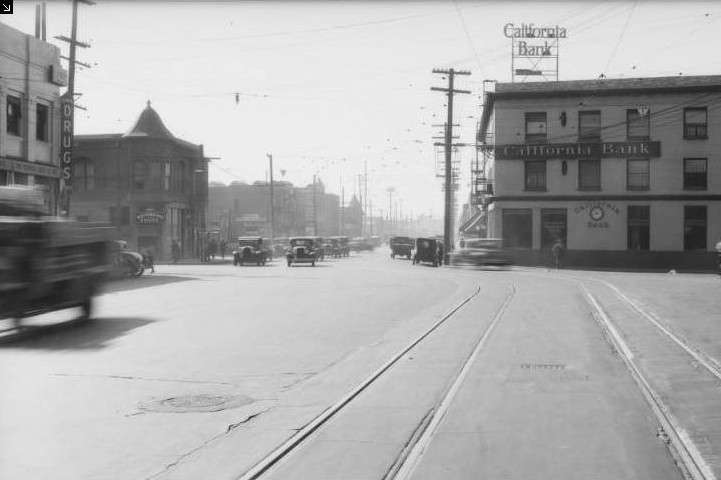
Dr. Hammel and his wife, in addition to begatting future Los Angeles County Sheriff William A. Hammel, also had an older daughter, Kate. In 1869 Kate married George Gard, who later became both City of Los Angeles Police Chief and Los Angeles County Sheriff (BTW, the 1931 Los Angeles Times map/model of 1881 Los Angeles has George Gard's home on San Pedro Street where the Hammel Palms were).

Among the children of George Gard and Kate Hammel was Georgetta Gard. Georgetta married actor Hal De Forrest, whose real name was Aloysius J. De Sylva. In 1895 Georgetta and Aloysius had a son whom they named George Gard De Sylva. He grew up to be known as Buddy DeSylva, songwriter ("California, Here I Come" "April Showers", among others), film producer (20 Century Fox, Paramount), and record executive (a founder of Capitol Records).

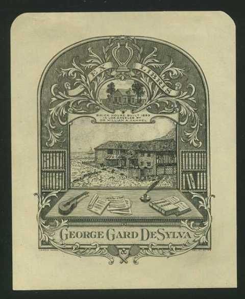
In 1934, James Elwood Webb designed a bookplate for DeSylva:

Antiquariat.de -- http://www.antiquariat.de/tigross.js...&orig=1&head=2

The text under the small house at the top of the page says, "Brick House Built 1853 In Los Angeles By Dr. William A. Hammel." Is this the house behind (north of) the famous Hammel/Arcade Palm? I dunno. But Buddy knew who his great-grandpa was, anyhow.

Info from: http://archive.org/stream/illustrate...e/486/mode/2up and http://www.askart.com/AskART/artists...&artist=109421 and http://www.allmusic.com/artist/buddy...a-mn0000638913 and http://www.nndb.com/people/361/000205743/

Last edited by Flyingwedge; May 31, 2013 at 5:52 AM.
Reply With Quote
     
     
  #14906  
Old Posted May 31, 2013, 6:39 PM
tovangar2 tovangar2 is offline
Registered User
 
Join Date: Nov 2012
Location: West Los Angeles
Posts: 2,625


Thx! Fascinating :-)


His Walk of Fame star is outside the Capital Records building, 1750 N Vine

http://projects.latimes.com/hollywoo...uddy-de-sylva/

Last edited by tovangar2; Jun 30, 2015 at 2:23 AM.
Reply With Quote
     
     
  #14907  
Old Posted May 31, 2013, 7:42 PM
Oviatt Building Fan Oviatt Building Fan is offline
Registered User
 
Join Date: Jun 2012
Posts: 49
Amazing mid-1930s movie studio stock footage of a drive from the Hollywood area down to the Wilshire district ... I think. Or maybe it's just along Wilshire Boulevard. Lots of great buildings and signage throughout.


Click on: http://youtu.be/rkkjpDmf7zw
Reply With Quote
     
     
  #14908  
Old Posted May 31, 2013, 8:38 PM
rbpjr rbpjr is offline
Registered User
 
Join Date: Mar 2011
Posts: 117
This is how you traveled from Long Beach to Terminal Island before there was a bridge. This was a floating two piece pontoon bridge. It was built during WW II and was slated to last a few months. It lasted for almost a quarter century. I rode over this bridge many times on my way to the base on T.I. Back in the day it was called "the milk run". I was stationed at Naval Station Long Beach in the late 1960s. That old Navy base is long gone and is now a Chinese container terminal.
[/QUOTE]

I was stationed at the Pacific Reserve Fleet in 1952 on a destroyer tender at the end of the causeway at the Naval Station on Terminal Island...we maintained a couple of dozen mothballed destroyers at that time. I was wondering if the pontoon bridge was between Terminal Island and Long Beach? The picture doesn't look familiar but it may have been there in 1952.
Reply With Quote
     
     
  #14909  
Old Posted May 31, 2013, 10:24 PM
tovangar2 tovangar2 is offline
Registered User
 
Join Date: Nov 2012
Location: West Los Angeles
Posts: 2,625
New town?
4.5" X 6.75" B&W photo:

hb surfer / eBay


Drive-in dress shop, 13 Oct 1936, Los Angeles
7" X 9" original press photo
(note the Johnnie Walker billboard)

afox11 - auctions / eBay

Last edited by tovangar2; May 31, 2013 at 11:40 PM.
Reply With Quote
     
     
  #14910  
Old Posted May 31, 2013, 10:37 PM
ethereal_reality's Avatar
ethereal_reality ethereal_reality is offline
Registered User
 
Join Date: Feb 2008
Location: Lafayette/West Lafayette IN, Purdue U.
Posts: 16,350
What are the people standing on in the first photo? It's like 'stairs to nowhere'.
Reply With Quote
     
     
  #14911  
Old Posted May 31, 2013, 11:11 PM
Graybeard's Avatar
Graybeard Graybeard is offline
Comfortably Numb
 
Join Date: Apr 2012
Location: Houston, Texas
Posts: 117
Quote:
Originally Posted by ethereal_reality View Post
What are the people standing on in the first photo? It's like 'stairs to nowhere'.
Whatever it is, it's the largest one.

Reply With Quote
     
     
  #14912  
Old Posted May 31, 2013, 11:15 PM
ethereal_reality's Avatar
ethereal_reality ethereal_reality is offline
Registered User
 
Join Date: Feb 2008
Location: Lafayette/West Lafayette IN, Purdue U.
Posts: 16,350
Good eye Graybeard. I didn't see that.
Reply With Quote
     
     
  #14913  
Old Posted May 31, 2013, 11:54 PM
CityBoyDoug CityBoyDoug is offline
BANNED
 
Join Date: Apr 2013
Posts: 2,868
The old pontoon bridge....

Quote:
Originally Posted by rbpjr View Post
This is how you traveled from Long Beach to Terminal Island before there was a bridge. This was a floating two piece pontoon bridge. It was built during WW II and was slated to last a few months. It lasted for almost a quarter century. I rode over this bridge many times on my way to the base on T.I. Back in the day it was called "the milk run". I was stationed at Naval Station Long Beach in the late 1960s. That old Navy base is long gone and is now a Chinese container terminal.
I was stationed at the Pacific Reserve Fleet in 1952 on a destroyer tender at the end of the causeway at the Naval Station on Terminal Island...we maintained a couple of dozen mothballed destroyers at that time. I was wondering if the pontoon bridge was between Terminal Island and Long Beach? The picture doesn't look familiar but it may have been there in 1952.[/QUOTE]

rbpjr....yes, the old WW II pontoon bridge was in place and being used in 1952. It was the only East-West road connection to Terminal Island. There was a North-South road connection to T.I. that utilized the railroad drawbridge and the East connection was by ferry boat.
This is the Northside lift bridge.

T.I. is to the Left. Photo above is looking West.

This is how you accessed T.I. before 1968*. Pontoon bridge, lift bridge and the Ferry Boat. Since then there have been many changes. [* In 1961 a large bridge was built to connect San Pedro and T.I. The Ferry Boat service was discontinued at that time]..

[/SIZE]

Last edited by CityBoyDoug; Jun 1, 2013 at 12:33 AM.
Reply With Quote
     
     
  #14914  
Old Posted May 31, 2013, 11:59 PM
mdiederi's Avatar
mdiederi mdiederi is offline
4
 
Join Date: Sep 2006
Location: JT
Posts: 4,933
Here's another interesting photo of the Gerald Desmond, not sure what's going on with that plane in the water. Don't know the date, but the old-style cargo crane suggests it was a few decades ago.


http://www.worldaffairsboard.com/wor...te-bridge.html

And another of the pontoon bridge. There are still working oil wells in that area.


http://digitallibrary.usc.edu/cdm/si...d/90456/rec/24


I've been driving across the Gerald Desmond twice a week lately and posted a photo of the construction for the new bridge in the Los Angeles Metro Development thread. So far they are just drilling holes in the ground still and will probably take another four or five years to complete.
Reply With Quote
     
     
  #14915  
Old Posted Jun 1, 2013, 12:11 AM
KevinW KevinW is offline
Registered User
 
Join Date: Oct 2010
Posts: 169
That plane in the water is the one and only Spruce Goose with Howard Hughes at the Controls on its maiden (and only) flight.


[QUOTE=mdiederi;6148909]Here's another interesting photo of the Gerald Desmond, not sure what's going on with that plane in the water. Don't know the date, but the old-style cargo crane suggests it was a few decades ago.


http://www.worldaffairsboard.com/wor...te-bridge.html
Reply With Quote
     
     
  #14916  
Old Posted Jun 1, 2013, 12:19 AM
CityBoyDoug CityBoyDoug is offline
BANNED
 
Join Date: Apr 2013
Posts: 2,868
WW II...again

[QUOTE=KevinW;6148925]That plane in the water is the one and only Spruce Goose with Howard Hughes at the Controls on its maiden (and only) flight.


Quote:
Originally Posted by mdiederi View Post
Here's another interesting photo of the Gerald Desmond, not sure what's going on with that plane in the water. Don't know the date, but the old-style cargo crane suggests it was a few decades ago.


http://www.worldaffairsboard.com/wor...te-bridge.html
That floating crane [Right side] is the famous German Heavy Lifting Crane that the US seized after WW II. It was named "Herman The German". It was towed over from Germany, through the Panama Canal and up the coast. Its now been given to Panama. The date of this photo is year 1980. That's when the huge plane was moved to its new hangar next to the Queen Mary ship. The plane is now in Oregon state.

http://news.google.com/newspapers?ni...g=4086,6322937
Reply With Quote
     
     
  #14917  
Old Posted Jun 1, 2013, 12:23 AM
Flyingwedge's Avatar
Flyingwedge Flyingwedge is offline
Registered User
 
Join Date: Jun 2012
Location: Los Angeles
Posts: 1,127
[QUOTE=KevinW;6148925]That plane in the water is the one and only Spruce Goose with Howard Hughes at the Controls on its maiden (and only) flight.


Quote:
Originally Posted by mdiederi View Post
Here's another interesting photo of the Gerald Desmond, not sure what's going on with that plane in the water. Don't know the date, but the old-style cargo crane suggests it was a few decades ago.


http://www.worldaffairsboard.com/wor...te-bridge.html
KW, I think the photo shows the Spruce Goose being moved from its Hughes hangar in 1980 for display next to the RMS Queen Mary.
Reply With Quote
     
     
  #14918  
Old Posted Jun 1, 2013, 1:15 AM
KevinW KevinW is offline
Registered User
 
Join Date: Oct 2010
Posts: 169
You're so right. I should have noticed the distinct lack of engines on the plane... I had no idea they had it in the water when they moved it. Although I'm probably thinking of when it finally left L.A.
Reply With Quote
     
     
  #14919  
Old Posted Jun 1, 2013, 1:41 AM
ethereal_reality's Avatar
ethereal_reality ethereal_reality is offline
Registered User
 
Join Date: Feb 2008
Location: Lafayette/West Lafayette IN, Purdue U.
Posts: 16,350
Terminal Drug Co. at 798 S. Central Avenue & E. 8th Street, circa 1933.


http://digitallibrary.usc.edu/


2011. The sealed off building today/actually the southwest corner of the Terminal Market

gsv


Aerial view of the Terminal Market. (I've outlined the Terminal Drug Store in red)

1930s

http://digitallibrary.usc.edu/cdm/si...id/90051/rec/2


Terminal Drug Store detail


Looking east on E. 8th Street toward S. Central Avenue and the Terminal Drug Store.

1933

http://digitallibrary.usc.edu/


Looking south on S. Central Avenue toward E. 8th Street and the California Bank. The Terminal Drug Store is on the left.

1933

http://digitallibrary.usc.edu/


detail


I like the clock in the wall and the 'walk-up' teller window.


http://digitallibrary.usc.edu/


An interesting building on the southeast corner of the E. 8th Street & S. Central Ave.(California Bank is on the right)


http://digitallibrary.usc.edu/


Looking along the east side of S. Central Ave. (with Terminal Drugs at left)


http://digitallibrary.usc.edu/


detail of the block south/I'm surprised to see a Wings Place.

http://digitallibrary.usc.edu/


same view today. blah! -from vibrant to sterile.

gsv
__

Last edited by ethereal_reality; Jun 1, 2013 at 2:16 AM.
Reply With Quote
     
     
  #14920  
Old Posted Jun 1, 2013, 3:47 AM
westcork westcork is offline
Registered User
 
Join Date: Jan 2011
Posts: 189
May Co under Construction 1939 "Vintage Los Angles"

http://www.youtube.com/watch?v=TC_LfsFZw4k
Reply With Quote
     
     
This discussion thread continues

Use the page links to the lower-right to go to the next page for additional posts

Reply

Go Back   SkyscraperPage Forum > Photography Forums > Found City Photos
Forum Jump


Forum Jump


All times are GMT. The time now is 5:55 PM.

     
SkyscraperPage.com - Archive - Privacy Statement - Top

Powered by vBulletin® Version 3.8.7
Copyright ©2000 - 2024, vBulletin Solutions, Inc.