I wanted to bring this up here so we could discuss it.
The two things I've been most shaky about on the map were the Sherman Way spur of the Gold line and the whole South LA east-west connector lines (Orange line and Slauson line).
 ELIMINATING THE SHERMAN WAY LINE
Now I'd really like to see a line down Sherman Way. It's a wide boulevard, with so much density (its lined with 3 & 4 story apartment buildings with dozens of units in each) and there is so many redevelopment/infill opportunities and potential to add lush landscaping. Plus the major east-west streets to the north and south of Sherman Way have similar are pretty much the same.
But, the reality is the San Fernando Valley busway (a.k.a. the MTA Orange line) which is much further south of Sherman Way is already in operation, it is a big success and as I either learned here or on the Transit Coalition board, one of the conditions of the MTA getting the money from the state to build the line is that it MUST be eventually converted to rail. I'm less concerned about that last part, because I've got to bet some law could be passed to get around that, but nonetheless, I'm looking to add a little bit more credibility to the map, before I start talking to the big dogs about it. Everyone who is anyone looks at the map thinks, "Well what about the just converting the Orange line to rail?" and probably thinks the Sherman Way spur is wasteful. So I'm thinking about
:
1) Getting rid of the Sherman Way segment of the Gold line (streetcars, with more frequent stops may be a better fit anyway).
2) Making the Orange line its own line from Burbank Media Center to Warner Center.
The difficulty getting the Orange line from Burbank Airport to North Hollywood station was one of the reasons I liked the Sherman Way spur so much. But with plans already in the making to extend the San Fernando Valley busway to Burbank Airport, might as well.
My thinking is to continue the Orange line east down Chandler (at-grade), north up North Hollywood Way (elevated) and east down the ROW (at-grade) to Burbank Media Center.
Now there likely will be community opposition to the Chandler segment, since it is currently a bike path. But I think two things could help with that:
1) Use a short cut-and-cover tunnel to get from Chandler to North Hollywood Way to contain the noise from the turn. (This incidentally is probably the best if not only way to make that almost "S"-like turn anyway).
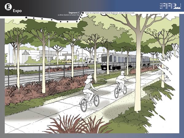
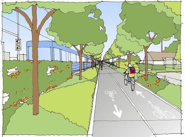
2) Preserve the bikeway and construct this part of the line just like the Expo ROW "Transit Corridors" are currently designed:
Now the Gold line Ventura Blvd elevated line, would remain, and the Reseda & Nordhoff spur (connecting CSUN and the Northridge mall to the system) would branch off at Ventura/Reseda. (This has the added benefit of being a corridor already identified as needing north-south connector service by MTA, per the draft Long Range Transportation Plan.
Thoughts?
SOUTH LA EAST-WEST CONNECTOR
It always bothered me that there would be no east-west connector between the Expo and Green line, especially since this is area is completely transit dependent (look at the draft LRTP to see what I mean). And even if we converted the Slauson ROW to light rail that still wouldn't be enough. Florence, Manchester and Century are all surrounded by density and lower-income citizens. My solution as you see from the map is the LAXpress and the Florence line. I partially picked Florence because, its ridership is currently high enough to warrant Rapid service, it better connects with the portion of my Orange line east of the Blue line, but I've always wanted to move the line down to Manchester so it could tie in more South LA residents.
With the Slauson ROW currently being studied by the MTA I think it might be wiser to advocate for a Slauson line and a Manchester line. I'm going to check the density and ridership stats to be sure this is a smart move today. This would allow the Manchester line to pull from everything from Florence to Century, while Slauson line could pull from the Vernon to Florence.
The lines would split from the Firestone/Atlantic station, with the Manchester line going down the Independence Ave ROW to Firestone (which turns into Manchester) to the Aviation Blvd ROW, down the ROW and terminating at an LAX station, while the Slauson line would continue to Salt Lake/Florence then Randolph/Pacific, down the Slauson ROW to Centinela/Florence and assuming the final six stops of the Orange line all the way to Playa Vista.
(Incidentally, I now realize I misnamed a station. Salt Lake/Firestone should actually be Salt Lake/Florence.)
This would not prevent an LAXpress line from using the ROW, but it probably would be wisest if it were light rail as well.
Oh and since I'm going to convert the San Fernando Valley busway to rail and its currently known as the Orange line, I'm going to need to rename my Orange line. Any ideas? When picking the color keep in mind how well it would go over with Councilman Parks.


 Prev
Prev


 Linear Mode
