HomeDiagramsDatabaseMapsForum About
     

Go Back   SkyscraperPage Forum > Regional Sections > Canada > Atlantic Provinces


Reply

 
Thread Tools Display Modes
     
     
  #61  
Old Posted Dec 14, 2009, 8:48 PM
Dmajackson's Avatar
Dmajackson Dmajackson is offline
Moderator
 
Join Date: Feb 2008
Location: B3K Halifax, NS
Posts: 9,346
^I'll put up my preliminary one in a couple of hours.

Does anyone know the minimum height a bridge has to be to allow shipping traffic below?
Reply With Quote
     
     
  #62  
Old Posted Dec 14, 2009, 9:59 PM
Dmajackson's Avatar
Dmajackson Dmajackson is offline
Moderator
 
Join Date: Feb 2008
Location: B3K Halifax, NS
Posts: 9,346
Here's my rough idea so far;


Basically using Google Earth I followed the gentlest sloped path as possible keeping within a reasonable distance of the Strait. The birdge approaches are at approximately 100m above sea level, the lowest point is 55m between Kings Road and Highway 105 (there's a cove with steep slopes to the airport which is over 100m high), and the highest point is 115m just north of Hwy 105.

From the existing CB 104 the new freeway heads north-west for 2.25km. Along this section one diamond (Crandall Rd) and one half parclo (Trunk 4) would be constructed. Because of the proximity of the interchanges the freeway would six lanes wide with a depressed median

At 2.25km in the freeway will turn west then north-west crossing Kings Road. This section covers approximately 2.15km (4.40km) and will be built to four-lane depressed median standards. No interchanges are planned.

North-west of Kings Road the highway will be carefully built into the cove slopes and continue for 4.51km (~9.0km)crossing Highway 105 in an underpass. Near the end the road will curve west. A half parclo interchange will be constructed for the northside of the Hwy 105 underpass.

Approximately 9.0km in a brand new state-of-the-art 4km bridge will cross the Canso Strait. The bridge will be deisgned for 6 six lanes divided of traffic but will be initially built for four lanes divided. Included in the bridge a seperated multi-use trail will be built to provide a future crossing for the Trans Canada Trail.

The western approaches to the bridge will consist of a standard diamond interchange and connector to Trunk 4 and toll booths.

In all the new section of Highway 104 will be 13-14km long and be divided and four lanes.

For construction reasons I would suggest breaking it into three phases; Phase I would be the Port Hawkesbury bypass (Trunk 4 to Crandall), Phase II would extend the bypass up to Highway 105, and Phase III would be the bridge and approaches.
Reply With Quote
     
     
  #63  
Old Posted Dec 15, 2009, 12:35 AM
Smevo's Avatar
Smevo Smevo is offline
Sarcstic Caper in Exile
 
Join Date: Mar 2004
Location: Calgary
Posts: 3,112
^Looks good. For time reasons, I didn't bother looking at terrain since I was just doing a rough idea, but I'm glad you had. I don't think you'll have an issue with shipping clearance, since most of the traffic on that side of the strait is pleasure-craft. There's the occasional barge that passes through the causeway locks, but most of the shipping traffic enters and leaves the strait from the ice-free side. I would assume the causeway locks/channel would have to be widened to accomodate anything that would create a clearance issue with you're bridge height.

I can see why you did the phases the way you did for construction reasons, my only comment on them is that it should be two phases, with phase 1 being your first two phases, then phase 2 being your phase 3. The reason I say this is the bypass wouldn't be overly useful as a bypass until both phase 1 and 2 of your plan were completed.

There's some property-line issues with the bridge on the CB side, but in all other areas you've avoided those nicely. On that point, since you're crossing King's Rd in a clearing between two stretches with houses on them, would you overpass or underpass King's Rd?

Overall, very nicely done.
__________________
Just another Caper in Alberta...
Reply With Quote
     
     
  #64  
Old Posted Dec 15, 2009, 8:56 PM
Dmajackson's Avatar
Dmajackson Dmajackson is offline
Moderator
 
Join Date: Feb 2008
Location: B3K Halifax, NS
Posts: 9,346
Quote:
Originally Posted by Smevo View Post
^Looks good. For time reasons, I didn't bother looking at terrain since I was just doing a rough idea, but I'm glad you had. I don't think you'll have an issue with shipping clearance, since most of the traffic on that side of the strait is pleasure-craft. There's the occasional barge that passes through the causeway locks, but most of the shipping traffic enters and leaves the strait from the ice-free side. I would assume the causeway locks/channel would have to be widened to accomodate anything that would create a clearance issue with you're bridge height.

I can see why you did the phases the way you did for construction reasons, my only comment on them is that it should be two phases, with phase 1 being your first two phases, then phase 2 being your phase 3. The reason I say this is the bypass wouldn't be overly useful as a bypass until both phase 1 and 2 of your plan were completed.

There's some property-line issues with the bridge on the CB side, but in all other areas you've avoided those nicely. On that point, since you're crossing King's Rd in a clearing between two stretches with houses on them, would you overpass or underpass King's Rd?

Overall, very nicely done.
The bridge could easily be lowered (allowing the approaches to be further down the hill on the CB side). For comparison the MacKay Bridge here in Halifax has a vertical clearance of 55m and has every type of watercraft imaginable going underneath.

The construction could easily be broken into 2 phases. I imagine the bridge would take at least three years to construct so starting on the bridge before the bypass is complete would be a good idea.

For Kings Road I'd have to say an overpass. The area is quite hilly (the two sections of houses have a 50m elevation difference!) so raising the road slighty would work the best (be cheaper than blasting).
Reply With Quote
     
     
  #65  
Old Posted Dec 15, 2009, 10:58 PM
Dmajackson's Avatar
Dmajackson Dmajackson is offline
Moderator
 
Join Date: Feb 2008
Location: B3K Halifax, NS
Posts: 9,346
As for the potential future routing of Highway 104 beyond St. Peter's I'm starting to draw a map but it is a very complex area because of the hills and lakes.

Here's a list including the map from earlier and as far as Soldiers Cove for where I think interchanges should be located;

Exit 39 - Trunk 4 Connecter & Toll Booths
Exit 40 - Trunk 105 near Port Hastings
Exit 41 - Kings Road*
Exit 42 - Crandall Road in Port Hawkesbury
Exit 43 - Paint Street/Trunk 4 (existing) in Port Hawkesbury
Exit 44 - Port Malcolm Rd/Lower River Rd near Lower River Inhabitants
Exit 45 - Evanston Rd in Evanston
Exit 46 - Route 320 near Louisdale (existing)
Exit 47 - Sporting Mountain Rd near Gannes (existing)
Exit 48 - Trunk 4 Connector near River Tillard
Exit 49 - Pepperell West Bay Rd near St. Peter's
Exit 50 - Trunk 4 near Barra Head
Exit 51 - Soldiers Cove Rd near Soldiers Cove

*I included Kings Road becuase Exit 43 is already existing so the proposed Port Hawkesbury Bypass must have this included to line-up existing exit numbers.
Reply With Quote
     
     
  #66  
Old Posted Dec 16, 2009, 2:13 AM
Smevo's Avatar
Smevo Smevo is offline
Sarcstic Caper in Exile
 
Join Date: Mar 2004
Location: Calgary
Posts: 3,112
^You're Port Hawkesbury bypass route inspired me to take a closer look at my route and make some revisions. I actually made two options, one ending at Sydport Access Rd and the second ending at Hwy 125 in between the current Exits 7 and 8 (New 125 exit would be 7A).

I worked around property lines at first, then worked around terrain (eyeballed it rather than going through the work of trying to balance cut/fill), then double checked for property line issues.

Option 1


Exits (the first chunk is just a copy of Bedford DJ's exit scheme, since I think it works quite well):
Exit 39 - Trunk 4 Connecter & Toll Booths (Aulac/Mulgrave/Port Hastings/Inverness)
Exit 40 - Trunk 105 near Port Hastings (Port Hastings/Whycocomagh/Baddeck/Cabot Trail)
Exit 41 - Kings Road (Port Hawkesbury)
Exit 42 - Crandall Road (Port Hawkesbury)
Exit 43 - Paint Street/Trunk 4 (existing) (Port Hawkesbury/Cleveland)
Exit 44 - Port Malcolm Rd/Lower River Rd (Lower River Inhabitants)
Exit 45 - Evanston Rd (Evanston/Whiteside)
Exit 46 - Route 320 (existing) (Louisdale/Isle Madame)
Exit 47 - Sporting Mountain Rd near Gannes (existing)
Exit 48 - Trunk 4 Connector (River Tillard/St. Peter's)
Exit 49 - Oban Rd (St. Peter's/Oban)
Exit 50 - Pepperell St (St. Peter's/West Bay/Sampsonville/L'Ardoise)
Exit 51 - Trunk 4 (Lynche River/Barra Head)
Exit 52 - Soldier's Cove Rd (Soldier's Cove/Potlotek)
Exit 53 - Hwy Cove Rd (Johnstown/Lake Uist/Loch Lomond)
Exit 54 - Irish Cove Rd (Irish Cove/Lake Uist)
Exit 55 - Loch Lomond Rd (Big Pond/Terra Nova/Lake Uist/Loch Lomond)
Exit 56 - Trunk 4 (Big Pond/Ben Eion)
Exit 57 - Rte 216 (East Bay/Eskasoni/Iona)
Exit 58 - Gillis Lake Rd (East Bay/Blackett's Lake/Sydney Forks)
Exit 59 - Mountain Rd (Coxheath)
Exit 60 E/W - Hwy 125 at Sydport Access Rd (E-Sydney/Membertou/Louisbourg/Glace Bay/New Waterford
W- North Sydney/Sydney Mines/Newfoundland Ferry)


Option 2
Red is where the route differs from Option 1, so I'll just start the exits from River Tillard.


Exits:
Exit 48 - Trunk 4 Connector (River Tillard/St. Peter's)
Exit 49 - Oban Rd (St. Peter's/Oban)
Exit 50 - Pepperell St (St. Peter's/West Bay/Sampsonville/L'Ardoise)
Exit 51 - Trunk 4 (Lynche River/Barra Head)
Exit 52 - Soldier's Cove Rd (Soldier's Cove/Potlotek/Johnstown)
Exit 53 - Hwy Cove Rd (Lake Uist/Loch Lomond)
Exit 54 - Irish Cove Rd (Irish Cove/Lake Uist)
Exit 55 - Loch Lomond Rd (Big Pond/Terra Nova/Enon/Ben Eion)
Exit 56 - Morley Rd (Portage/East Bay/Marion Bridge/Ben Eion)
Exit 57 - Rte 327 (Gabarus/Marion Bridge)
Exit 58 - Caribou Marsh Rd (Caribou Marsh/Front Lake)
Exit 59 - Front Lake Rd (Dutch Brook/Front Lake/Prime Brook)
Exit 60 E/W - Hwy 125 between Exits 7 & 8 (would be 7A on Hwy 125) (E-Sydney/Louisbourg/Glace Bay/New Waterford
W- Sydney/Membertou/North Sydney/Sydney Mines/Newfoundland Ferry)


Option 1 cuts down times from the current fastest route this way (all measured to downtown, except North Sydney which is to NL Ferry Terminal):
North Sydney - 12 minutes
Sydney - 20 minutes
Glace Bay - 20 minutes
New Waterford - 20 minutes
Louisbourg - 20 minutes

Options 2 cuts them down this way:
North Sydney - 5 minutes
Sydney - 16 minutes
Glace Bay - 22 minutes
New Waterford - 22 minutes
Louisbourg - 21 minutes.

I'd still like to see others thoughts on this, since, as you can see it gets me thinking about my own routes.
__________________
Just another Caper in Alberta...
Reply With Quote
     
     
  #67  
Old Posted Dec 16, 2009, 4:22 AM
Dmajackson's Avatar
Dmajackson Dmajackson is offline
Moderator
 
Join Date: Feb 2008
Location: B3K Halifax, NS
Posts: 9,346
^My routing would be very similar to Option 1. The only thing I might change is the major crossing over Sydney River.
Reply With Quote
     
     
  #68  
Old Posted Dec 16, 2009, 6:51 PM
Smevo's Avatar
Smevo Smevo is offline
Sarcstic Caper in Exile
 
Join Date: Mar 2004
Location: Calgary
Posts: 3,112
I revised option one first, and the main reason for the crossing was to eliminate the new access roads at Ben Eion and Rte 216 extension in my original routing. If the crossing remained in the routing, it could probably be angled more if the curves proved too sharp for the design standards (again, I eyeballed rather than going through the calculations). There's a steep hill on the north side of Rte 216, so I was aiming for a more gradual climb on that end of the crossing. It would likely be a causeway crossing, as there's a causeway crossing for a local road in the bay just north of this location.

The lack of crossings was one of the pros for option 2, though I purposely swung well east to try to limit faster access from Sydney to its suburbs to cut down on local traffic. There's room for a flyover interchange there, which is what I think would be necessary at that point, but as Membertou expands that room will start to disappear on the north side of 125. Option 1 would definitely not be any faster for Sydney to suburbia, so I doubt the existing interchange at Exit 5 (Sydport Access Rd) would need much in improvements. The traffic levels should still make a diamond interchange sufficient there, but if a better one was needed, there is a lot more room on that one. There's also plenty of room for Sydport Access Rd to be realigned to an improved interchange if the suburban development in Coxheath starts to close in, but if the ROW is secured relatively soon, that won't be an issue.

I was checking different area maps on the CBRM website with property lines roughed in, and there is no existing ROW for a new 104 that I could make out, so it would have to be secured. However, much of the property that these two options would go through is already municipally or provincially owned and they would just have to adjust the boundaries or subdivide to create a ROW corridor.
__________________
Just another Caper in Alberta...
Reply With Quote
     
     
  #69  
Old Posted Dec 16, 2009, 9:29 PM
Smevo's Avatar
Smevo Smevo is offline
Sarcstic Caper in Exile
 
Join Date: Mar 2004
Location: Calgary
Posts: 3,112
Trunks are now done, so I'll try to get those up this weekend.
__________________
Just another Caper in Alberta...
Reply With Quote
     
     
  #70  
Old Posted Dec 18, 2009, 8:42 PM
Smevo's Avatar
Smevo Smevo is offline
Sarcstic Caper in Exile
 
Join Date: Mar 2004
Location: Calgary
Posts: 3,112
NS Trunk Highways: ADT

I'll only do the lists for AADT, and I'm cutting out AADT/lane for these and the collectors (I'll probably only do AADT for the collectors) because the road geometry changes too quickly from rural back highway to suburban arterial to urban arterial (you could have all three within 2km in some parts) so it would clutter up the maps too much, not to mention that the satellite photo resolution is still lacking in some of the urban areas of NS (namely Truro).

Anyway, here's the maps for Average Daily Traffic. Again, all maps made by me using Google Maps Satellite Imagery.

Nova Scotia

Busiest Section - Tk7 between Dartmouth/Bedford line and Rte 322 (39,120) (Dartmouth)

Cape Breton

Busiest Section - Tk4 between Hwy 125 (E of Sydney) and Gardiner Rd (32,336) (Sydney)

North NS

Busiest Section - Tk2 between Truro line (North) and Hwy 102 I/C (Exit 14) (21,879) (Truro)

Halifax Region

Busiest Section - Tk7 between Dartmouth/Bedford line and Rte 322 (39,120) (Dartmouth)

South NS

Busiest Section - Tk3 between Yarmouth town line (East) and Tk 1 (22,211) (Yarmouth)

Metro Halifax

Busiest Section - Tk7 between Dartmouth/Bedford line and Rte 322 (39,120) (Dartmouth)

Metro Sydney

Busiest Section - Tk4 between Hwy 125 (E of Sydney) and Gardiner Rd (32,336) (Sydney)


Now for the Individual Highways
Trunk 1

Busiest Section - between Cobequid Rd and Beaverbank Rd, Lower Sackville (25,069)

Trunk 2

*Busiest Section - between Truro line (North) and Hwy 102 I/C (Exit 14), Truro (21,879)
*Tk 2 counts don't start until Waverly, so I wouldn't be surprised if the Bedford Hwy section actually had higher counts than this, but I can only go on what I know from the book itself.

Trunk 3

Busiest Section - between Yarmouth town line (East) and Tk 1, Yarmouth (22,211)

Trunk 4

Busiest Section - between Hwy 125 (E of Sydney) and Gardiner Rd, Sydney (32,336)

Trunk 6

Busiest Section - Lake Rd to Rte 311, Tatamagouche (6,273)

Trunk 7

Busiest Section - between Dartmouth/Bedford line and Victoria Rd, Dartmouth (39,120)

Trunk 8

Busiest Section - between Liverpool town line and Tk 3, Liverpool (6,426)

Trunk 10

Busiest Section - between Cooks Brook Bridge and Bridgewater Town Line, Bridgewater (12,112)

Trunk 12

Busiest Section - between Hwy 101 (Exit 13) and English Mountain Rd, Kentville (4,051)

Trunk 14

Busiest Section - between Rte 215 (Brooklyn) and Hwy 101, Windsor (6,430)

Trunk 16

Busiest Section - between Rte 344 (Boylston) to Guysborough Town Line, Guysborough (2,223)

Trunk 19 (Ceilidh Trail)

Busiest Section - between Port Hastings Rotary and Creignish Mountain Rd, Port Hastings (4,023)

Trunk 22

Busiest Section - between Sydney city line and Hwy 125, Sydney (14,059)

Trunk 28

Busiest Section - between Sydney city line and Tk 4 (Prince St), Sydney (14,312)

Trunk 30 (Cabot Trail)

Busiest Section - between Petit Etang and Point Cross, Cheticamp (6,861)

Trunk 32 (Northwest Arm Dr)

Busiest Section - between Main Ave and Old Sambro Rd*, Halifax (21,024)
*the concentration actually happens E of Albert Walker Dr, so that's why the map looks like it does.

Trunk 33 (Bedford Bypass)

Busiest Section - between Tk 7 and Hwy 101, Bedford (25,956)
__________________
Just another Caper in Alberta...
Reply With Quote
     
     
  #71  
Old Posted Dec 18, 2009, 9:22 PM
Dmajackson's Avatar
Dmajackson Dmajackson is offline
Moderator
 
Join Date: Feb 2008
Location: B3K Halifax, NS
Posts: 9,346
^Not surprised to see that the Magazine Hill is so busy. I live a kilometre or so away and that roads packed 24/7.

Smevo didn't mention this exactly but the busiest section is Trunk 7 in Burnside which is Windmill Road. Doesn't surprise me the area has most of the regional truck traffic, tens of thousands of commuters heading downtown or into Burnside/City of Lakes/Dartmouth Crossing, and tonnes of buses a day all crammed into four through lanes (two each way), a two way left turn lane, and bus/right-turn lane each way.

Smevo, just a request. Can you possibly find the raw number for Trunk 7 through Bedford (between Trunk 33 and Trunk 2)?
Reply With Quote
     
     
  #72  
Old Posted Dec 18, 2009, 9:25 PM
Smevo's Avatar
Smevo Smevo is offline
Sarcstic Caper in Exile
 
Join Date: Mar 2004
Location: Calgary
Posts: 3,112
NS Trunk Highways: AADT

Trunk Highways Ranked by busiest section:
Trunk 7
Trunk 4
Trunk 33
Trunk 1
Trunk 32
Trunk 2
Trunk 3
Trunk 28
Trunk 22
Trunk 10
Trunk 14
Trunk 30
Trunk 8
Trunk 6
Trunk 12
Trunk 19
Trunk 16

Top 30 busiest sections, Trunk Highways:
Rank) Trunk # - Section, city/town (AADT)

1) Trunk 7 - Dartmouth/Bedford Line to Victoria Rd, Dartmouth (37,600)
2) Trunk 4 - Hwy 125 to Gardiner Rd, Sydney (33,300)
3) Trunk 4 - Hwy 125 (Sydney River) to Sydney River/Sydney line, Sydney (28,700)
4) Trunk 4 - Sydney/Grand Lake Road Line to Hwy 125 (26,700)
5) Trunk 33 - Tk 7 to Hwy 101, Bedford (25,400)
6) Trunk 7 - Forest Hills Parkway to Hwy 107 (East Preston), Preston (24,600)
7) Trunk 1 - Cobequid Rd to Beaverbank Rd, Lower Sackville (24,500)
8) Trunk 1 - Hwy 102 to Cobequid Rd, Lower Sackville (24,300)
9) Trunk 32 - Main Ave to Old Sambro Rd, Halifax (23,150)
10) Trunk 7 - Bedford Bypass to Dartmouth/Bedford Line, Bedford (23,000)
11) Trunk 4 - Sydney River/Sydney Line to Sydney/Grand Lake Rd Line, Sydney (22,100)
12) Trunk 1 - New Minas/Greenwich Line to Kentville/New Minas Line, New Minas (21,920)
T13) Trunk 2 - Truro Town Line (S) to Truro Town Line (N), Truro (19,800)
T13) Trunk 3 - Yarmouth Town Line to Tk 1, Yarmouth (19,800)
15) Trunk 2 - Truro Town Line (N) to Hwy 102, Truro (19,400)
16) Trunk 7 - Victoria Rd to Micmac Parclo, Dartmouth (18,390)
17) Trunk 7 - Hwy 107 (East Preston) to Minesville Rd, Preston (17,230)
18) Trunk 4 - Gardiner Rd to Wilson Rd, Glace Bay (17,110)
19) Trunk 1 - Tk 12 to Kentville/Coldbrook Line, Kentville (15,150)
20) Trunk 1 - Kentville/Coldbrook Line to Cambridge Mountain Rd, Kentville (14,900)
21) Trunk 2 - Amherst Town Line (S) to Amherst Town Line (N), Amherst (14,500)
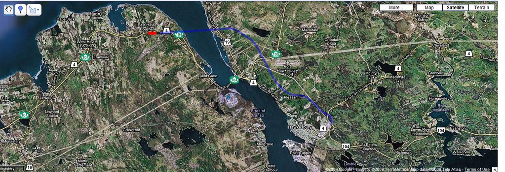
22) Trunk 4 - Granville St to Hwy 104, Port Hawkesbury (14,330)
23) Trunk 28 - Sydney/South Bar Line to Tk 4 (Prince St), Sydney (13,600)
T24) Trunk 1 - Yarmouth Town Line to Ferry Terminal, Yarmouth (13,200)
T24) Trunk 4 - Meadows Rd to Hwy 125, Sydney (13,200)
26) Trunk 3 - Hwy 103 (Beechville I/C) to Timberlea Village Parkway, Halifax (13,080)
27) Trunk 1 - Kentville/New Minas Line to Tk 12, Kentville (12,800)
T28) Trunk 2 - Hwy 102 (Fall River) to Sunnylea Rd, Fall River (12,600)
T28) Trunk 22 - Sydney City Line to Hwy 125, Sydney (12,600)
30) Trunk 1 - Wolfville/Lower Wolfville Line to Greenwich/Wolfville Line, Wolfville (12,500)


And now the maps:

Nova Scotia Trunk Highways

Busiest Section - Trunk 7 - Dartmouth/Bedford Line to Victoria Rd, Dartmouth (37,600)

Cape Breton

Busiest Section - Trunk 4 - Hwy 125 to Gardiner Rd, Sydney (33,300)

North NS

Busiest Section - Trunk 2 - Truro Town Line (S) to Truro Town Line (N), Truro (19,800)

Halifax Region

Busiest Section - Trunk 7 - Dartmouth/Bedford Line to Victoria Rd, Dartmouth (37,600)

South NS

Busiest Section - Trunk 3 - Yarmouth Town Line to Tk 1, Yarmouth (19,800)

Metro Halifax

Busiest Section - Trunk 7 - Dartmouth/Bedford Line to Victoria Rd, Dartmouth (37,600)

Metro Sydney

Busiest Section - Trunk 4 - Hwy 125 to Gardiner Rd, Sydney (33,300)

Individual Trunks
Trunk 1

Busiest Section - Cobequid Rd to Beaverbank Rd, Lower Sackville (24,500)

Trunk 2

Busiest Section - Truro Town Line (S) to Truro Town Line (N), Truro (19,800)

Trunk 3

Busiest Section - Trunk 3 - Yarmouth Town Line to Tk 1, Yarmouth (19,800)

Trunk 4

Busiest Section - Hwy 125 to Gardiner Rd, Sydney (33,300)

Trunk 6

Busiest Section - Busiest Section - Lake Rd to Rte 311, Tatamagouche (4,450)

Trunk 7

Busiest Section - Dartmouth/Bedford Line to Victoria Rd, Dartmouth (37,600)

Trunk 8

Busiest Section - between Liverpool town line and Tk 3, Liverpool (5,900)

Trunk 10

Busiest Section - between Cooks Brook Bridge and Bridgewater Town Line, Bridgewater (10,900)

Trunk 12

Busiest Section - between Hwy 101 (Exit 13) and English Mountain Rd, Kentville (3,850)

Trunk 14

Busiest Section - between Rte 215 (Brooklyn) and Hwy 101, Windsor (6,500)

Trunk 16

Busiest Section - between Rte 344 (Boylston) to Guysborough Town Line, Guysborough (2,020)

Trunk 19

Busiest Section - between Port Hastings Rotary and Creignish Mountain Rd, Port Hastings (3,170)

Trunk 22

Busiest Section - Sydney City Line to Hwy 125, Sydney (12,600)

Trunk 28

Busiest Section - Sydney/South Bar Line to Tk 4 (Prince St), Sydney (13,600)

Trunk 30

Busiest Section - between Petit Etang and Point Cross, Cheticamp (6,080)

Trunk 32

Busiest Section - Main Ave to Old Sambro Rd, Halifax (23,150)

Trunk 33

Busiest Section - Tk 7 to Hwy 101, Bedford (25,400)
__________________
Just another Caper in Alberta...
Reply With Quote
     
     
  #73  
Old Posted Dec 18, 2009, 9:35 PM
Smevo's Avatar
Smevo Smevo is offline
Sarcstic Caper in Exile
 
Join Date: Mar 2004
Location: Calgary
Posts: 3,112
Quote:
Originally Posted by Bedford_DJ View Post
Smevo, just a request. Can you possibly find the raw number for Trunk 7 through Bedford (between Trunk 33 and Trunk 2)?
Unfortunately, they don't start reporting the counts until the Bedford Bypass. It seems by the location of their counts that they try to get kind of a trip generation/destination idea, since they tend to skip large lengths of probably busier local road sections. The only trunks I didn't see them do this with are the really low traffic ones. They skipped a lot of in-city sections of Halifax and Sydney, and in-town sections of New Glasgow, Amherst, New Waterford and Glace Bay (among others).

I'm sure there's good reasons for this, maybe some of the missing info will pop up in local road counts which I'm going to look at after the collectors so I can do "comprehensive" traffic maps for the urban areas in NS. I'm going to cut off a lot of the lower-traffic routes for that one, I'm thinking right now I'll make the cutoff at 5,000, but I may change that to 10,000 as I go through it. The colour scheme will remain the same though.
__________________
Just another Caper in Alberta...
Reply With Quote
     
     
  #74  
Old Posted Dec 19, 2009, 4:00 AM
Architype's Avatar
Architype Architype is offline
♒︎ Empirically Canadian
 
Join Date: Mar 2004
Location: 🍁 Canada
Posts: 11,980
Say hello to Atlantic Canada's newest highway, just opened to the public, mainly route 500 & 510 I believe, over 1100 km. There is not much traffic yet.

Quote:
The final section of the Trans-Labrador Highway, stretching between an area near Cartwright in the south to Happy Valley-Goose Bay in central Labrador, is now connected.

The overall highway, which has a mostly gravel surface, runs for hundreds of kilometres. Its route goes from the western mining towns of Labrador City and Wabush across the territory and then along the coast to fishing communities in southern Labrador.


http://www.cbc.ca/canada/newfoundlan...or-091209.html

http://www.cbc.ca/canada/newfoundlan...-lab-1216.html

http://www.thetelegram.com/index.cfm?sid=311749&sc=79
Reply With Quote
     
     
  #75  
Old Posted Dec 19, 2009, 6:20 AM
Smevo's Avatar
Smevo Smevo is offline
Sarcstic Caper in Exile
 
Join Date: Mar 2004
Location: Calgary
Posts: 3,112
That makes my (extremely expanded) Cross-Canada trip I'm hoping to do whenever I move back East a bit easier. I'll just have to remeber to fill up in Happy Valley-Goose Bay and bring along several extra jerry-cans of gas.
__________________
Just another Caper in Alberta...
Reply With Quote
     
     
  #76  
Old Posted Dec 21, 2009, 10:33 PM
Dmajackson's Avatar
Dmajackson Dmajackson is offline
Moderator
 
Join Date: Feb 2008
Location: B3K Halifax, NS
Posts: 9,346
This was originally posted in the Halifax section. Its the official plans for the Hwighway 107 Extension (Burnside Expressway) here in Bedford/Dartmouth scheduled to be built in a couple of years.

Quote:
Originally Posted by kph06 View Post
This is interesting, its similar to the drawing in the pdf above, but this includes the final plan for the 102/101 interchange area, exit 3 and 4 on the 102 would be merged into one massive interchange, it's complicated, but services every road and should really move quite smooth. It takes a few minutes to take it all in. The red is the existing conditions, black is proposed.
Reply With Quote
     
     
  #77  
Old Posted Dec 22, 2009, 5:30 AM
Architype's Avatar
Architype Architype is offline
♒︎ Empirically Canadian
 
Join Date: Mar 2004
Location: 🍁 Canada
Posts: 11,980
Here's some info about Metro St. John's N.L.'s newest highway, yet to be completed.

" When completed, the Team Gushue Highway will eventually terminate at the . . . .Goulds Bypass-Pitts Memorial interchange, with a total length of 9.6 kilometres. It is estimated the second phase will total $40 million and will be cost-shared between municipal, provincial and federal governments."
http://www.releases.gov.nl.ca/releas...tw/0622n04.htm

"When it's finished in 2011, the highway — named after Brad Gushue, who skipped Canada to a gold medal in men's curling at the 2006 Torino Olympics — will connect (The TCH in the north of St John's) with the Goulds Bypass Road " (South of Mount Pearl).
http://www.cbc.ca/canada/newfoundlan...ay-191109.html

Here's an old map (can't find a proper one), showing the route, and updated to show approximate interchange locations.


This will be a four lane divided controlled access highway, or freeway. At the highest elevations it will have some great panoramic views of the city. The completed section in the north is called route 3A, and will connect to route 3 in the south (probably will all eventually be called route 3), and will then connect with route 10, the Southern Shore Highway. This will service much of St. Johns' existing and newly developing suburban areas in the Northwest and Southwest, as well as Mount Pearl and points South. Phase one in the North is complete, and the rest is supposed to be finished in 2011.

This highway project has recently been controversial because of funding disagreements over maintenance between St.John's and Mount Pearl. These disagreements stalled the construction process until now.
Reply With Quote
     
     
  #78  
Old Posted Dec 22, 2009, 11:28 PM
Smevo's Avatar
Smevo Smevo is offline
Sarcstic Caper in Exile
 
Join Date: Mar 2004
Location: Calgary
Posts: 3,112
Looks good Architype. Too bad you couldn't find the updated version. You've got to love those funding/maintenance disagreements, eh?

@ Bedford - the 107 extension looks good. It should take a bit of the heat off 118 when it's completely finished, and possibly the Bedford Bypass and Tk 7 up to Burnside as well.
__________________
Just another Caper in Alberta...
Reply With Quote
     
     
  #79  
Old Posted Dec 22, 2009, 11:53 PM
Smevo's Avatar
Smevo Smevo is offline
Sarcstic Caper in Exile
 
Join Date: Mar 2004
Location: Calgary
Posts: 3,112
Combined tables - 100 series and Trunks

Busiest by busiest section on highway:
Hwy 102
Tk 7
Hwy 118
Tk 4
Hwy 101
Hwy 103
Hwy 125
Tk 33
Tk 1
Tk 32
Hwy 104
Tk 2
Tk 3
Hwy 107
Hwy 105
Tk 28
Tk 22
Hwy 106
Tk 10
Tk 14
Tk 30
Tk 8
Tk 6
Tk 19
Tk 16
Hwy 142
Hwy 162

50 Busiest Hwy Sections (**=2 lane 100-series freeway, *=2 lane trunk)
1) Hwy 102 between Exits 1 & 1A (53,000)
2) Hwy 102 between Exits 1A & 2A (45,100)
3) Hwy 102 between Exits 3 & 4 (45,000)
4) Hwy 102 between Exits 0 & 1 (43,180)
5) Hwy 102 between Exits 2A & 2 (40,100)
6) Hwy 102 between Exits 2 & 3 (39,500)
7) Hwy 102 between Exits 5 & 5A (39,500)
8) Trunk 7 between Dartmouth/Bedford Line & Victoria Rd (37,600)
9) Hwy 102 between Exits 5A & 6 (37,000)
10) Hwy 118 between Hwy 111 & Exit 12 (34,200)
11) Trunk 4 between Hwy 125 & Gardiner Rd (33,300)
12) Hwy 101 between Tk 1 & Exit 2 (32,570)
T13) Hwy 102 between Exits 4 & 4C (29,800)
T13) Hwy 102 between Exits 6 & 7 (29,800)
15) Hwy 103 between Exits 1 & 2 (29,100)
16) Trunk 4 between Hwy 125 & Sydney/Sydney River line (28,700)
17) Hwy 102 between Exits 14 & 14A (27,900)
18) Hwy 125 between Exits 7 & 8 (26,880) **
19) Trunk 4 between Sydney/Grand Lake Rd Line & Hwy 125 (26,700)
20) Trunk 33 between Hwy 7 & Hwy 101 (25,400)
21) Trunk 7 between Forest Hills Pkwy & Hwy 107 (24,600)
22) Hwy 102 between Exits 7 & 8 (24,600)
23) Trunk 1 between Cobequid Rd & Beaverbank Rd (24,500)
24) Hwy 118 between Exit 13 & Hwy 102 (24,400)
T25) Trunk 1 between Hwy 102 & Cobequid Rd (24,300)
T25) Hwy 102 between Exit 4C & 5 (24,300)
27) Hwy 118 between Victoria Rd & Hwy 111 (24,200)
28) Hwy 125 between Exits 6 & 7 (24,000) **
29) Hwy 118 between Exits 12 & 13 (23,500)
30) Trunk 32 between Main Ave & Old Sambro Rd (23,150)
31) Trunk 7 between Bedford Bypass & Dartmouth/Bedford Line (23,000)
T32) Hwy 102 between Exits 12 & 13A (22,600)
T32) Hwy 104 between Exits 23 & 24 (22,600)
34) Hwy 102 between Exits 13 & 14 (22,400)
35) Hwy 102 between Exits 13A & 13 (22,200)
36) Trunk 4 between Sydney River/Sydney Line & Sydney/GLR Line (22,100)
37) Hwy 103 between Exits 2 & 3 (21,990)
38) Trunk 1 between New Minas/Greenwich Line & New Minas/Kentville Line (21,920)*
39) Hwy 102 between Exits 8 & 9 (21,000)
40) Hwy 104 between Exits 24 & 25 (20,700)
41) Hwy 102 between Tk 2 & Hwy 118 (20,400)
42) Hwy 102 between Exits 10 & 11 (20,300)
43) Hwy 102 between Exits 9 & 10 (20,100)
44) Hwy 102 between Exits 14A & 15 (20,030)
45) Hwy 103 between Exits 3 & 4 (19,810)
T46) Tk 2 between Truro Town Line (S) & Truro Town Line (N) (19,800)*
T46) Tk 3 between Yarmouth Town Line & Tk 1 (19,800)*
48) Hwy 104 between Exits 13 & 15 (19,700)
49) Hwy 104 between Exits 22 & 23 (19,490)
50) Tk 2 between Truro Town Line (N) & Hwy 102 (19,400)

For the section of Tk 2 in Truro, although the counts were taken on Robie St which is 4-lane, a good section of what constitutes Tk 2 in town is still 2-lane. I would guess that only Robie St reaches the level of traffic indicated, but I still marked the section with an asterisk because of the 2-lane parts of the section in town.

BTW, they've finally updated satellite imagery for Truro...as if on cue.
__________________
Just another Caper in Alberta...

Last edited by Smevo; Dec 24, 2009 at 6:48 AM. Reason: Finishing off Top 50
Reply With Quote
     
     
  #80  
Old Posted Dec 23, 2009, 2:22 AM
Dmajackson's Avatar
Dmajackson Dmajackson is offline
Moderator
 
Join Date: Feb 2008
Location: B3K Halifax, NS
Posts: 9,346
^I think that list proves that the 102 needs to be widened and upgraded desperately. I find it funny that only spot #10 has a proper collector/express system in place.
Reply With Quote
     
     
This discussion thread continues

Use the page links to the lower-right to go to the next page for additional posts
 
 
Reply

Go Back   SkyscraperPage Forum > Regional Sections > Canada > Atlantic Provinces
Forum Jump


Forum Jump


All times are GMT. The time now is 6:02 PM.

     
SkyscraperPage.com - Archive - Privacy Statement - Top

Powered by vBulletin® Version 3.8.7
Copyright ©2000 - 2024, vBulletin Solutions, Inc.