Quote:
Originally Posted by Ferreth

You would think that only in the age of satellites and jet planes that anyone would have thought to write anything on the roof of their building. But even in 1951 when flying was expensive and a lot slower, you can find an arrow pointing to " Calgary 2 M" on top of one of the tanks at the Lynwood Ridge refinery. |
That type of thing was everywhere, they served as a form of navigational aide.
Quote:
|
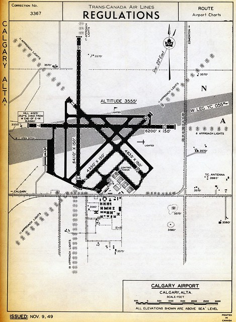
What I didn't know is that a rail spur line went to the McCall Airport. At least the earth works continued off into the NE ending around Stoney and 64th. I assume it served the air force during WWII, but the only thing I can think of for a NE spur is a temporary line to bring in fill for the airport. The line isn't even listed in "Lines of Country: An Atlas of Railway and Waterway History in Canada", so it might have been very ephemeral.
|
I would suggest you contact the Transport Canada archives, but Harper defunded Transport Canada's archives to save less than $300,000 a year. In the 1960's Transport Canada commissioned exhaustive histories of every airport in the country, the history is sixty volumes in length. If there was a rail spur it will be in there, plotted and explained in great detail. Glenbow should have a copy as should U of C.
A nerd could die of old age there and not see a tenth of it. 100,000+ publications dating from 1825 to the present day. Much of the collection will be/has been destroyed.
Bitter? A little. The US Department of Transportation now has a more complete archive of Canadian transportation material than the archives in Ottawa.


 Prev
Prev


 Linear Mode
