With a friend, we have followed the extension of line 14 which should open by the second half of 2020.
The line 14 northern extension will relieve the overcrowding of northern line 13 and serve many new developments.

1.We begin in the 17th arrondissement of Paris in the Clichy Batignolles redevelopement area. Above the station Pont Cardinet.
 Place Françoise Dorin, 17e
 by
Minato ku, sur Flickr
2.
 Rue Mstislav Rostropovitch, 17e
 by
Minato ku, sur Flickr
3.
 Rue Mstislav Rostropovitch, 17e
 by
Minato ku, sur Flickr
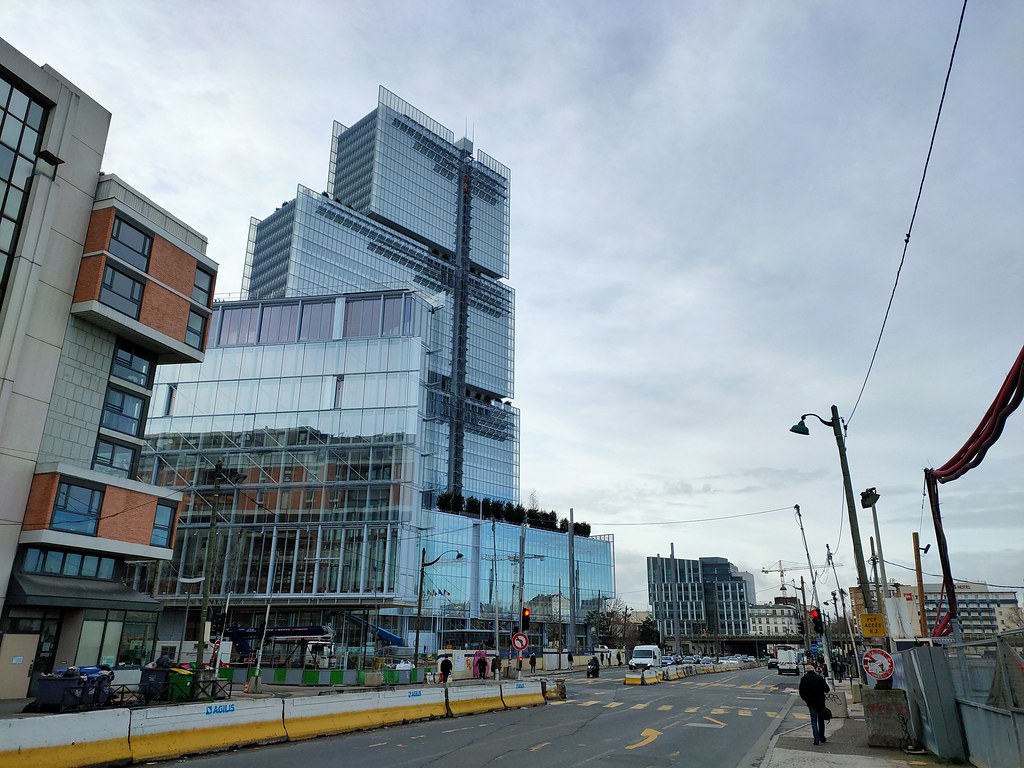
4. This skyscraper is the new main courthouse of Paris.
It's the first building above 150m/500ft built since 1973 in the inner part of Paris.
Porte de Clichy is going to become a bigger hub with the opening of the line 14 northern extension. Tram T3b, metro line 13, metro line 14 and RER C.
 Avenue de la Porte de Clichy, 17e
 by
Minato ku, sur Flickr
5.
 16 Rue André-Suarès, 17e
 by
Minato ku, sur Flickr
6. Other side of the Peripherique, in the inner suburbs of Clichy.
 Boulevard Jean Jaures, Clichy
 by
Minato ku, sur Flickr
7.
 Rue Bonnet, Clichy
 by
Minato ku, sur Flickr
8.
 Boulevard Victor Hugo, Clichy
 by
Minato ku, sur Flickr
9.
 Boulevard Victor Hugo, Clichy
 by
Minato ku, sur Flickr
10. See the difference between the massive office building and the small old residential buildings
 Boulevard du Général Leclerc, Clichy
 by
Minato ku, sur Flickr
11.
 Rue Georges Boisseau, Clichy
 by
Minato ku, sur Flickr
12. A bit further away, the site of Saint-Ouen station. It's already served by the RER C.
 Rue Dora Maar, Saint-Ouen
 by
Minato ku, sur Flickr
13.
 Boulevard Victor Hugo, Saint-Ouen
 by
Minato ku, sur Flickr
13. The area is a mix of modern office and residencial developmenet with older industrial buildings
 Rue Arago, Saint-Ouen
 by
Minato ku, sur Flickr
14. Gresillion line railway tracks. This part of the line is not anymore in use for passengers traffic.
Passengers service have been replaced by the underground tracks for the RER C. Now it's only for industrial use.
 Ligne des Grésillons, Saint-Ouen
 by
Minato ku, sur Flickr
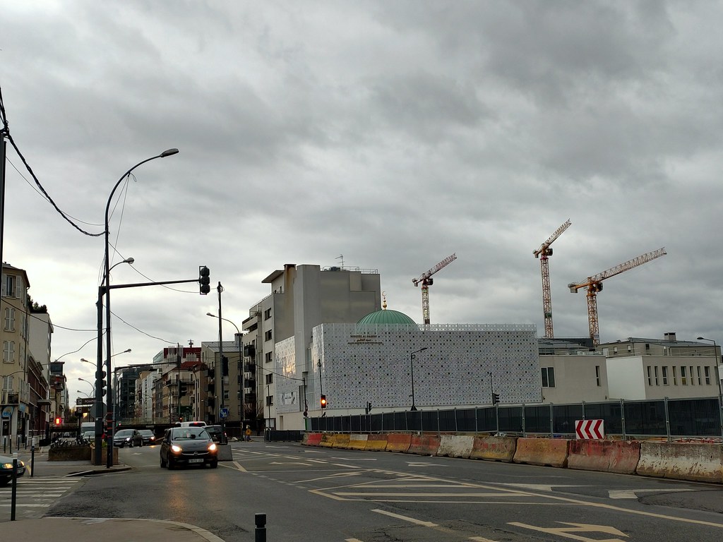
15. The new Mosque of Saint-Ouen
 Boulevard Victor Hugo, Saint-Ouen
 by
Minato ku, sur Flickr
16. Former industrial area in redevelopment
 Boulevard Victor Hugo, Saint-Ouen
 by
Minato ku, sur Flickr
17.
 Boulevard Victor Hugo, Saint-Ouen
 by
Minato ku, sur Flickr
18.
 Villa de l'Industrie, Saint-Ouen
 by
Minato ku, sur Flickr
19.
 Rue Ernest Renan, Saint Ouen
 by
Minato ku, sur Flickr
20.
 Boulevard Victor Hugo, Saint Ouen
 by
Minato ku, sur Flickr
21. Entrances of the new Mairie de Saint-Ouen for line 14.
Mairie de Saint-Ouen will become the first interchange between two metro lines outside the Peripherique beltway. Served by line 13 and 14.
 Rue Albert Dhalenne, Saint-Ouen
 by
Minato ku, sur Flickr
22.
 Boulevard Jean Jaures, Saint-Ouen
 by
Minato ku, sur Flickr
23. Ice rink of Saint-Ouen
 Rue du Docteur Bauer, Saint-Ouen
 by
Minato ku, sur Flickr
24.
 Boulevard Jean Jaures, Saint-Ouen
 by
Minato ku, sur Flickr
25. The high-rises in the back are where used to be the old town of Saint-Ouen. It has been demolished.
 Rue du Docteur Léonce Basset, Saint_Ouen
 by
Minato ku, sur Flickr
26. Her at the interesection with Rue du Landy, the municipal border between Saint-Ouen and Saint-Denis
 Boulevard Jean Jaures, Saint-Ouen
 by
Minato ku, sur Flickr
27. Today only served by a branch of line 13, Pleyel district will become one of biggest hub in Paris.
This extension of line 14 should open by 2024 and then the new lines 15, 16 and 17.
A new bridge above the tracks coming from Gare du Nord will also create a connection with the RER D station Saint-Denis Stade de France.
It means 6 lines serving the area.
 Boulevard Anatole France, Saint-Denis
 by
Minato ku, sur Flickr
28. In the background, the Sacré Coeur Basilica in Montmartre
 Boulevard Ornano, Saint-Ouen
 by
Minato ku, sur Flickr
29. Pleyel tower, this tower isn't abandonned, it has completely emptied to carry out work for a luxury hotel.
As you may imagine most of these small old building will be replaced.
 Boulevard Ornano, Saint-Ouen
 by
Minato ku, sur Flickr
30. Carrefour Pleyel metro station, the station opened in 1952.
Until 1976, it was the last station of the Saint-Denis branch of line 13.
 Carrefour Pleyel, metro line 13
 by
Minato ku, sur Flickr
An aerial view of Pleyel. This district of Saint-Denis is separated from the rest of Saint-Denis by the A86 highway in the north and the track from Gare du Nord.
As you could see, it's next to the RER D station of Saint-Denis Stade de France but because the lack of overpass or underpass above the tracks, on foot a big detour is needed.
 Pleyel
 by
Minato ku, sur Flickr


 Linear Mode
