HomeDiagramsDatabaseMapsForum About
     

Go Back   SkyscraperPage Forum > Photography Forums > Found City Photos

Reply

 
Thread Tools Display Modes
     
     
  #53701  
Old Posted Feb 4, 2020, 4:48 PM
odinthor's Avatar
odinthor odinthor is offline
Registered User
 
Join Date: May 2015
Posts: 1,323
Speaking of Ascot Park, has this been seen on NLA?


LA Times, 11/19/1903, via ProQuest, via CSULB Library
Reply With Quote
     
     
  #53702  
Old Posted Feb 4, 2020, 8:32 PM
HossC's Avatar
HossC HossC is offline
Registered User
 
Join Date: Aug 2013
Posts: 4,245


Ascot Park and some of the streetcar lines show up on the 1910 (below) and 1914 Baist maps, although none of the racetrack or the loop is shown.


www.historicmapworks.com

From an LAT article titled 'L.A.'s Auto Racing Heyday Began Early':
In the first decades of the century, Indianapolis wasn’t the auto racing capital of the world. Los Angeles was, especially after road racing became popular, first at Corona, then at tracks such as Ascot Park, on Slauson Avenue, south of Exposition Park.
...
Ascot was the first of many tracks named Ascot in the Southland. Originally built for horse racing, it was razed in 1919 to make way for a tire factory.
The 1921 Baist map shows the streetcar realigned to South Park Avenue (now S Avalon Boulevard) and the whole block where Ascot Park once stood simply labeled "Goodyear Tire & Rubber Co of Calif". By 1927, nothing much remains other than the sewer pipe works (top & center in the map above).


mil.library.ucsb.edu
Reply With Quote
     
     
  #53703  
Old Posted Feb 5, 2020, 6:29 AM
Flyingwedge's Avatar
Flyingwedge Flyingwedge is offline
Registered User
 
Join Date: Jun 2012
Location: Los Angeles
Posts: 1,126
More Ascot Park/Speedway


That looks like this place (the photo is dated March 5, 1916, which was Sunday):

Quote:
Originally Posted by procab View Post

Also see CHS-10043 at the USC Digital Library for a 1918 aerial view of this facility.
Reply With Quote
     
     
  #53704  
Old Posted Feb 5, 2020, 6:55 AM
ethereal_reality's Avatar
ethereal_reality ethereal_reality is offline
Registered User
 
Join Date: Feb 2008
Location: Lafayette/West Lafayette IN, Purdue U.
Posts: 16,344
Thanks for the follow-ups on the Oakland drill team panorama, odinthor. . .HossC. . .Flyingwedge.

I imagine the street where the drill team posed would be in the vicinity of the park.


I just happened upon yet another interesting parade photograph.

"Vintage Photo 1915 Los Angeles LA FIESTA DE LOS FLORES PARADE 9th & Hill St."


Link

The first thing I noticed was the Hotel Yale because I don't recall a hotel with that name in Los Angeles.

(perhaps we've seen it under a different name)

There's a good view of Trinity Auditorium down the street.


The back is interesting as well.


search purposes: La Fiesta de los Flores

.
Reply With Quote
     
     
  #53705  
Old Posted Feb 5, 2020, 7:13 AM
ethereal_reality's Avatar
ethereal_reality ethereal_reality is offline
Registered User
 
Join Date: Feb 2008
Location: Lafayette/West Lafayette IN, Purdue U.
Posts: 16,344
.


By coincidence, this sepia photograph was also on ebay. (it's gone now)


The onion domed church in the mid-distance is the B'nai B'rith Synagogue located at Ninth & Hill Street. That's the same intersection that was shown in the previous post!

and, of course, there's the Trinity Auditorium again.


I have no idea why KFI is written along the top.
.
Reply With Quote
     
     
  #53706  
Old Posted Feb 5, 2020, 7:32 AM
Flyingwedge's Avatar
Flyingwedge Flyingwedge is offline
Registered User
 
Join Date: Jun 2012
Location: Los Angeles
Posts: 1,126
1909 Elks Parade Photo

Quote:
Originally Posted by ethereal_reality View Post


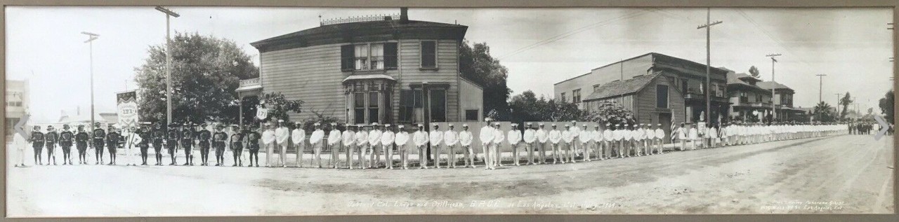
"Antique 1909 Oakland BPOE Drill Team In Los Angeles California Panoramic Photo".........................................................................................................................................................................


Link


I thought if we all work together we might be able to figure out where in Los Angeles this panorama of the Oakland BPOE Drill Team was taken.
From the July 15, 1909, Los Angeles Evening Express at Newspapers.com:

"Raymond Benjamin, grand esquire of the grand lodge and grand marshal for the parade of Elks, gave the command to move forward promptly at 10 o'clock.
A fanfare of trumpets, and the police mounted squadron swung into line at Main and Seventeenth street, cavorting down the lane of white pavement between
the massed humanity on each side."

Later . . .

"All along Main street from the point of the parade's beginning to its turning point at Temple block, on Spring street from Temple block to Ninth and again
on Broadway between First and Eighth the congestion of humanity was unprecedented."

And . . .

"For the benefit of the Elks themselves, so that those in line could have an opportunity to view marchers of their brother lodges, a countermarch on Broadway
from First to Eighth street was given."


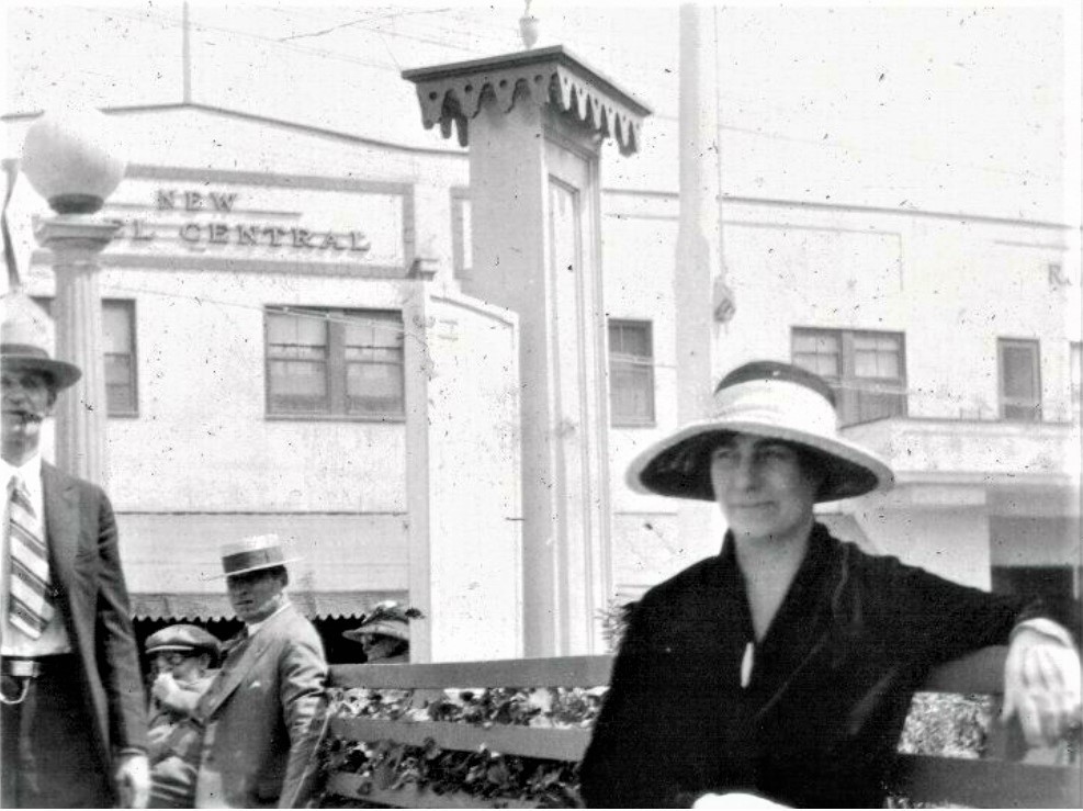
I would guess this photo was taken around the southern half of the parade route, given the lack of hills or large buildings in the background.
Reply With Quote
     
     
  #53707  
Old Posted Feb 5, 2020, 4:49 PM
odinthor's Avatar
odinthor odinthor is offline
Registered User
 
Join Date: May 2015
Posts: 1,323
With our house in the BPOE pic . . .


detail

. . . it struck me that such a broad expanse of the house's wall had no windows or other features. Then I noticed the discoloration showing that something had been there. A trellis? A removed wing of the house? Did the balcony at left come around the corner to the front of the house, perhaps making a first-story porch? Something is missing . . .
Reply With Quote
     
     
  #53708  
Old Posted Feb 5, 2020, 5:06 PM
oldstuff oldstuff is offline
Registered User
 
Join Date: Aug 2012
Posts: 623
Quote:
Originally Posted by Flyingwedge View Post
Great work, Hoss! This March 5, 1940, image shows the buildings under construction in e_r's photo look completed and the hillside behind appears to be a match,
the small rectangular gas station is there next to the highway, and the Lighthouse Restaurant is just across the road:


Flight C_6330, Frame 56 at UC Santa Barbara
The area where the Lighthouse Restaurant was located is on a triangular area jutting out into the ocean. The curved area to the south of that property was where the train tracks ran out to the Long Wharf. This is just to the north of Santa Monica Canyon. The Long Wharf (covered here elsewhere) was built in 1893 and operated until the port was moved to San Pedro. It was in its day, the longest wharf in the world. There is a historical marker there today located on the south side of the lifeguard headquarters.
Reply With Quote
     
     
  #53709  
Old Posted Feb 6, 2020, 2:12 AM
CityBoyDoug CityBoyDoug is offline
BANNED
 
Join Date: Apr 2013
Posts: 2,868
Quote:
Originally Posted by oldstuff View Post
The area where the Lighthouse Restaurant was located is on a triangular area jutting out into the ocean. The curved area to the south of that property was where the train tracks ran out to the Long Wharf. This is just to the north of Santa Monica Canyon. The Long Wharf (covered here elsewhere) was built in 1893 and operated until the port was moved to San Pedro. It was in its day, the longest wharf in the world. There is a historical marker there today located on the south side of the lifeguard headquarters.


Pierce collection

That Long Wharf was a wonderful coastal venue...one of the main items that was brought into LA from that landing was LUMBER.
Reply With Quote
     
     
  #53710  
Old Posted Feb 6, 2020, 4:28 AM
Flyingwedge's Avatar
Flyingwedge Flyingwedge is offline
Registered User
 
Join Date: Jun 2012
Location: Los Angeles
Posts: 1,126
Quote:
Originally Posted by ethereal_reality View Post
.

By coincidence, this sepia photograph was also on ebay. (it's gone now)


The onion domed church in the mid-distance is the B'nai B'rith Synagogue located at Ninth & Hill Street. That's the same intersection that was shown in the previous post!

I have no idea why KFI is written along the top.
.

Thanks for finding this interesting photo, though it looks south on Hope Street. I'd guess it was taken in 1924 (that's when the
Southern California Gas Company building, under construction at right, was completed). The "KFI" on the photo must refer to the
two faintly visible towers (the right-hand onion dome is about centered between them) supporting the station's hammock-style
antenna, which was near 10th/Olympic and Hope:

Quote:
Originally Posted by Flyingwedge View Post

This is the NCR building at 936 S. Hope, where the garage(s) had been. The CA State Library dates this photo and the next
three at c. 1923-33, but I'll say they are c. 1932. This photo looks south down Hope; the tower at right is one of the two for
KFI's "hammock" antenna:


CA State Library


In this c. 1938 photo, you can see the south end of the NCR building, how the building next door ("Pennzoil") had been
remodeled (compare with the first CA State Library photo above), as well as KFI's other tower from down the block,
across Olympic:


00012879 @ LAPL

Reply With Quote
     
     
  #53711  
Old Posted Feb 6, 2020, 6:07 AM
ethereal_reality's Avatar
ethereal_reality ethereal_reality is offline
Registered User
 
Join Date: Feb 2008
Location: Lafayette/West Lafayette IN, Purdue U.
Posts: 16,344
I appreciation the correction on the KFI photograph, Flyingwedge.


Snapshot listed on eBay.


This was written on the back > >
"1921-RODEO-BURBANK, CALIF."........................................................................................................................................


eBay.

That's quite an expanse of land!

The only place I can think of where this rodeo might have occured is the old horse track located a little south and inbetween First National/Warners and Walt Disney studios.

1948 Map

AMAZONMAPS

I know we have visited this horse track a few times on NLA but I don't recall the name.

A few silent movies, (maybe a few sound movies as well), used the horsetrack and surrounding land as a filming location.

.
Reply With Quote
     
     
  #53712  
Old Posted Feb 6, 2020, 6:52 AM
ethereal_reality's Avatar
ethereal_reality ethereal_reality is offline
Registered User
 
Join Date: Feb 2008
Location: Lafayette/West Lafayette IN, Purdue U.
Posts: 16,344
.

Mystery snapshot listed on eBay


eBay


If you look closely (see below), the "New Hotel Central" can be seen across the street.


detail

Soooo. . .I thought perhaps (I'm probably wrong) the New Hotel Central was located across from Central Station. That might explain the quasi-park-like area where the woman is sitting on the bench.

The thing that interests me the most is the ornate, square column that has a sign attached to it. I can't even imagine what the sign might say.


THIS JUST IN:

I found two Hotel Centrals in the 1921 Los Angeles Directory.


LAPL

........................................................214 Commercial...and....310 Clay


.
Reply With Quote
     
     
  #53713  
Old Posted Feb 6, 2020, 7:23 AM
ScottyB ScottyB is offline
Registered User
 
Join Date: Sep 2015
Location: Burbank
Posts: 187
Quote:
Originally Posted by ethereal_reality View Post
I appreciation the correction on the KFI photograph, Flyingwedge.


Snapshot listed on eBay.


This was written on the back > >
"1921-RODEO-BURBANK, CALIF."........................................................................................................................................


eBay.

That's quite an expanse of land!

The only place I can think of where this rodeo might have occured is the old horse track located a little south and inbetween First National/Warners and Walt Disney studios.

1948 Map

AMAZONMAPS

I know we have visited this horse track a few times on NLA but I don't recall the name.

A few silent movies, (maybe a few sound movies as well), used the horsetrack and surrounding land as a filming location.

.
I'm guessing the Burbank Equestrian Center, just north of what was the Lasky (or Provedencia) ranch where lots of filming was done. I think the eBay photo is looking NW. That part of Burbank was pretty wide open in 1921.


UCSB
1938

I love seeing the LA river unbound. Wouldn't be for long in this photo, channelization would begin that year.
Reply With Quote
     
     
  #53714  
Old Posted Feb 6, 2020, 11:49 PM
Lorendoc Lorendoc is offline
Registered User
 
Join Date: May 2013
Location: Los Angeles, California
Posts: 428
Mystery location and date


USC digital library

The caption says "Birdseye view of an unidentified city street, Los Angeles, [s.d.]." So where and when was this taken?

The trolley is signed with the letter "P" which I guess indicates the LARY route it is travelling. I'm sure people here can confirm or not that this was the case.


There are several named businesses that the city directories give addresses for, such as the Hotel Fresno at 1225 S Main and Bouquet Art Kraft at 118 W Pico. That would make the street running up the center of the picture Broadway. But this street dead-ends on Pico which seems weird. But here is the 1921 Baist which does indeed show Broadway ended at Pico.


historicalmapworks.com

So when did Broadway get extended south? Some digging found this:


LAT 3/16/27 via LAPL

...and other stories reported the opening of Broadway to the south finally was completed c. 1930 after lots of expensive eminent domain cases were settled by the city.

Here is a 1931 aerial showing Broadway extending beyond Pico. There are still some single-family residences, soon for the wrecking ball no doubt.


UCSB aerials

So the person who took the original photo must have been hanging out an upper-story window of the pretty tall building at the NW corner of 12th and Broadway. The 1950 Sanborn calls this the Occidental Life Building, but it started life as the nine-story Chamber of Commerce Building in 1926. So I'll say the picture was taken in 1928.


newspapers.com
Reply With Quote
     
     
  #53715  
Old Posted Feb 7, 2020, 5:44 AM
HenryHuntington HenryHuntington is offline
Registered User
 
Join Date: Apr 2013
Location: The OC
Posts: 279
[QUOTE=Lorendoc;8823509]

The trolley is signed with the letter "P" which I guess indicates the LARY route it is travelling. I'm sure people here can confirm or not that this was the case.


_____________

LARy's P Line through DTLA ran on 1st St., Broadway and Pico Blvd. So, yeah.
Reply With Quote
     
     
  #53716  
Old Posted Feb 7, 2020, 7:23 PM
ethereal_reality's Avatar
ethereal_reality ethereal_reality is offline
Registered User
 
Join Date: Feb 2008
Location: Lafayette/West Lafayette IN, Purdue U.
Posts: 16,344
Quote:
Originally Posted by ScottyB View Post
I'm guessing the Burbank Equestrian Center, just north of what was the Lasky (or Provedencia) ranch where lots of filming was done. I think the eBay photo is looking NW.
That part of Burbank was pretty wide open in 1921.
Thanks for your help with the ebay rodeo photograph, ScottyB. I believe there was also a 'Lasky Mesa' Ranch. (I'll have to look it up)


In the meanwhile:


Here's a mystery rppc that the eBay seller has designated as Santa Monica.

"1920's Santa Monica, California - REAL PHOTO Los Angeles Beach Town"


eBay


I could be wrong but I don't believe this is Santa Monica. To me, it looks like somewhere out near Palm Springs.

Is that a manmade ladder over on the left?


Here's what is written on the reverse.


A CLOSER LOOK.

Try as I might I can't decipher any words on the damn sign. (I adjusted the constrast a wee bit)


detail

It isn't even close to being legible. *shakes head in dismay*


.
Reply With Quote
     
     
  #53717  
Old Posted Feb 7, 2020, 7:29 PM
Lorendoc Lorendoc is offline
Registered User
 
Join Date: May 2013
Location: Los Angeles, California
Posts: 428
Wikipedia to the rescue: "Adelbert Bartlett was a commercial photographer based in Santa Monica, California, and the director of the Near East Relief Fund in Los Angeles."

Agree it is the desert. Bottom word could be "PALM"
Reply With Quote
     
     
  #53718  
Old Posted Feb 7, 2020, 7:50 PM
ethereal_reality's Avatar
ethereal_reality ethereal_reality is offline
Registered User
 
Join Date: Feb 2008
Location: Lafayette/West Lafayette IN, Purdue U.
Posts: 16,344
Here's a fun photograph showing three young lads sitting on their 'jalopy' in Southern California.

The seller believes it is Azusa.

"1929 Ford Model A Azusa CA AUG 6, 1942 A. J. Hartzell Market"


eBay (no longer listed)


Stamp on the reverse.


?......................................................................................................................

.

Last edited by ethereal_reality; Feb 8, 2020 at 12:23 AM.
Reply With Quote
     
     
  #53719  
Old Posted Feb 7, 2020, 8:12 PM
HossC's Avatar
HossC HossC is offline
Registered User
 
Join Date: Aug 2013
Posts: 4,245
Quote:
Originally Posted by ethereal_reality View Post

Here's a mystery rppc that the eBay seller has designated as Santa Monica.

"1920's Santa Monica, California - REAL PHOTO Los Angeles Beach Town"


eBay

I could be wrong but I don't believe this is Santa Monica. To me, it looks like somewhere out near Palm Springs.

Is that a manmade ladder over on the left?

Try as I might I can't decipher any words on the damn sign. (I adjusted the constrast a wee bit)


It isn't even close to being legible.
Quote:
Originally Posted by Lorendoc View Post

Bottom word could be "PALM"
There's some feint handwriting in the lower-left corner of the main photo which seems to say "1000 PALMS...". Could this be Thousand Palms in the Coachella Valley? Could this be e_r's "manmade ladder" on the right.


coachellavalleypreserve.org
Reply With Quote
     
     
  #53720  
Old Posted Feb 7, 2020, 8:35 PM
Lorendoc Lorendoc is offline
Registered User
 
Join Date: May 2013
Location: Los Angeles, California
Posts: 428
Hartzell Market

Quote:
Originally Posted by ethereal_reality View Post
Here's a fun photograph showing three young lads sitting on their 'jalopy' along the Southern California coast.

The seller believes it is Azusa.

"1929 Ford Model A Azusa CA AUG 6, 1942 A. J. Hartzell Market"


eBay (no longer listed)
It was Azusa.


newspapers.com

Today pretty bland:


GSV

...although maybe same palm trees?

Last edited by Lorendoc; Feb 7, 2020 at 8:57 PM.
Reply With Quote
     
     
This discussion thread continues

Use the page links to the lower-right to go to the next page for additional posts

Reply

Go Back   SkyscraperPage Forum > Photography Forums > Found City Photos
Forum Jump


Thread Tools
Display Modes

Forum Jump


All times are GMT. The time now is 10:46 PM.

     
SkyscraperPage.com - Archive - Privacy Statement - Top

Powered by vBulletin® Version 3.8.7
Copyright ©2000 - 2024, vBulletin Solutions, Inc.