HomeDiagramsDatabaseMapsForum About
     

Go Back   SkyscraperPage Forum > Discussion Forums > Transportation


Reply

 
Thread Tools Display Modes
     
     
  #1  
Old Posted Apr 18, 2011, 9:53 PM
M II A II R II K's Avatar
M II A II R II K M II A II R II K is offline
Registered User
 
Join Date: Aug 2002
Location: Toronto
Posts: 52,200
Will London’s New Wayfinding System Get More People Walking?

Will London’s New Wayfinding System Get More People Walking?


Apr 12th, 2011


Read More: http://thisbigcity.net/will-londons-...eople-walking/

Quote:
If you’ve walked through Covent Garden, Southbank or Oxford Street recently, the chances are you will have stumbled across the funky new Legible London pedestrian signs installed by Transport for London (TfL). These sleek, stylish ‘monoliths’ have been sprouting up all over the capital during the last year. Each monolith is strategically placed and has an easy-to-read map that is orientated to the users point of view, 5 and 15 minute walking distances, and 3D drawings of key shops and buildings in the area.

The thinking behind the new system is to encourage more people to walk around London instead of driving or using already overcrowded public transport. By catching people at key decision points – such as tube stations – and providing them with the right information on walking times and local attractions, it is hoped that they will choose to walk.

According to TfL, information really is key in achieving modal shift. Research found that most Londoners mental map of London is based on the tube map which is geographically distorted and can be very misleading. For instance there are over 100 connections on the underground where its quicker to walk than take the tube! Legible London maps will often show users that their destination is closer and more walkable than they think.

To provide Londoners with a coherent wayfinding system, the Legible London designers have broken the city down into three key spatial hierarchies:
  • Areas: ‘broad areas of the city’ such as the West End;
  • Villages: ‘commonly used names’ which Londoners use to quickly connect one part of the city to another;
  • Neighbourhoods: there are several neighbourhoods in each village.

TfL believe that this process of breaking places down, helps pedestrians to explore and find their way around the city. As you become more familiar with a particular place, the more you can keep sub-dividing it into smaller, linked pieces, creating a more detailed mental map.

.....


__________________
ASDFGHJK
Reply With Quote
     
     
  #2  
Old Posted Apr 18, 2011, 10:50 PM
electricron's Avatar
electricron electricron is offline
Registered User
 
Join Date: Aug 2008
Location: Granbury, Texas
Posts: 3,523
Lightbulb

Quote:
Looking at that last photo, either no one wants to bike here, or there wasn't enough bikes preposition here, because it appears all the racks are empty.
Reply With Quote
     
     
  #3  
Old Posted Apr 19, 2011, 9:11 AM
Greavsie Greavsie is offline
Registered User
 
Join Date: Feb 2010
Posts: 173
Quote:
Originally Posted by electricron View Post
Looking at that last photo, either no one wants to bike here, or there wasn't enough bikes preposition here, because it appears all the racks are empty.
the latter..ive seen those bloody things everywhere.
Reply With Quote
     
     
  #4  
Old Posted Apr 19, 2011, 10:38 AM
nito nito is offline
Registered User
 
Join Date: Mar 2004
Posts: 2,856
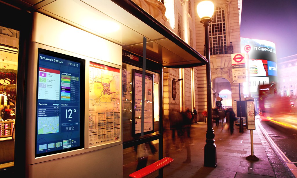
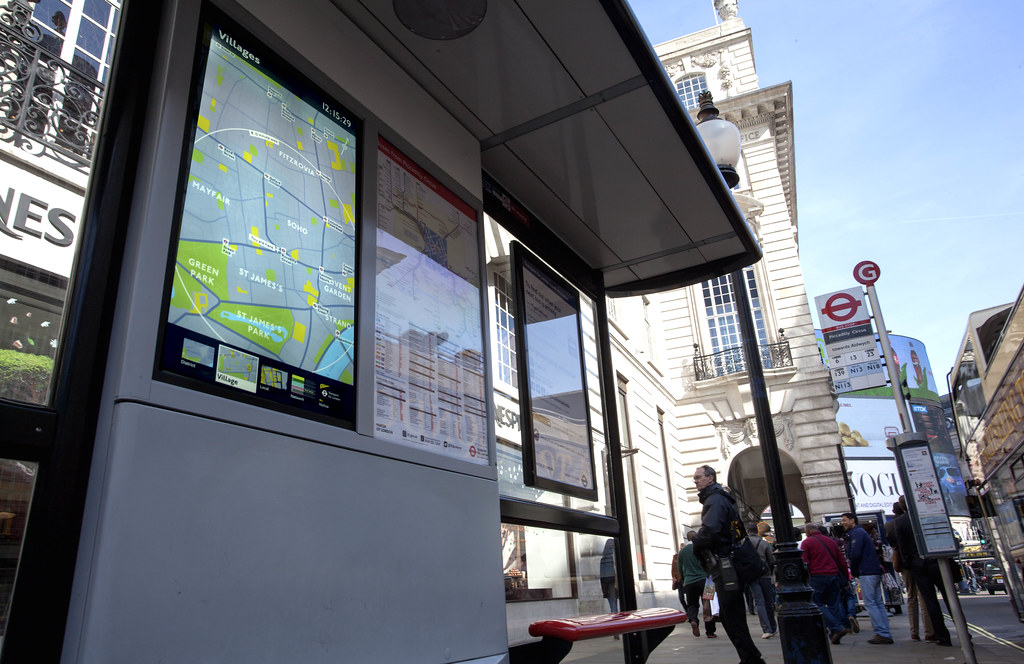
Over the years I've seen the various prototypes - the final version is definately of a high quality and should help tourists, especially with the citys' organic urban layout.

Although in some ways, getting lost amongst the maze of alleys and side-streets that dominate the main tourist areas is part of the charm of London. Quite often many of its highlights are off the beaten track.


Quote:
Originally Posted by electricron View Post
Looking at that last photo, either no one wants to bike here, or there wasn't enough bikes preposition here, because it appears all the racks are empty.
That photo was taken six days before the Cycle Hire scheme was launched, so I can presume that by then the bicycles had yet to be delivered to that location.

To my knowledge, Transport for London can track the usage of docking stations and operate these electric vehicles: http://en.wikipedia.org/wiki/File:BC...A8_ATX280E.JPG to re-allocate bikes to areas where required to ensure that there are sufficient numbers at heavily used spots.
__________________
London Transport Thread updated: 2023_07_12 | London Stadium & Arena Thread updated: 2022_03_09
London General Update Thread updated: 2019_04_03 | High Speed 2 updated: 2021_09_24
Reply With Quote
     
     
  #5  
Old Posted Apr 19, 2011, 2:44 PM
M II A II R II K's Avatar
M II A II R II K M II A II R II K is offline
Registered User
 
Join Date: Aug 2002
Location: Toronto
Posts: 52,200
Next there'll be touch screen interactive versions of them on the streets that will also have real time transit schedules and menus of nearby restaurants to display and stuff.
__________________
ASDFGHJK
Reply With Quote
     
     
  #6  
Old Posted Apr 20, 2011, 8:40 PM
micro's Avatar
micro micro is offline
Registered User
 
Join Date: Aug 2006
Posts: 73
Quote:
Originally Posted by M II A II R II K View Post

"the right information on walking times ..."
A good idea with one very obvious flaw: The circle is not the "right information on walking times". The line of equal walking times in a grid of streets can never be a circle. Some places can be reached via a straight road, others only around corners. The walking time is even longer if there are bodies of water in the way.

It should be no problem to generate the correct lines of equal walking times by using route planning algorithms.
Reply With Quote
     
     
  #7  
Old Posted Jun 8, 2015, 10:04 AM
paullarry paullarry is offline
Paul Larry
 
Join Date: Aug 2014
Location: United States
Posts: 3
For me the subway remains the best possible way to move around London when you in a hurry. However, here we talk about walking, so I do believe the wayfinding system could be of great use to people who want just to have a walk around the city.
__________________
Wayfinding Signage
Reply With Quote
     
     
  #8  
Old Posted Sep 4, 2015, 10:29 AM
DonaldE's Avatar
DonaldE DonaldE is offline
Daredevil
 
Join Date: Jun 2015
Location: United States
Posts: 1
Great post. So many places in London are much easier and nicer found by walking. In addition to these excellent new maps around the central area of London there are also some fantastic outer London walks.... I am a massive fan of the Capital Ring and the London Loop - excellent short and longer walks that take you to parts of the capital rarely seen by tourists or Londoners alike.
__________________
CNC Machining Services
Reply With Quote
     
     
  #9  
Old Posted Sep 5, 2015, 1:05 PM
mrnyc mrnyc is offline
cle/west village/shaolin
 
Join Date: Jul 2006
Posts: 11,722
those are very helpful for first time tourists and no doubt will encourage their walking, so if that is the primary goal they are a very good idea. however, after you have been exploring and have visited london a time or two you dont really need them. and they probably bug residents as an eyesore.
Reply With Quote
     
     
  #10  
Old Posted Sep 6, 2015, 8:05 AM
nito nito is offline
Registered User
 
Join Date: Mar 2004
Posts: 2,856
mrnyc - In the age of the smartphone you would have thought that actually these maps would have become obsolete, but that doesn’t appear to be the case. I suspect their success and continued deployment is down to their size (compared to a mobile screen) and the style which is easy to understand. I’m not sure how they could be considered an eyesore.

Which brings me on to another point actually made by M II A II R II K four years ago (!) that these are first generation versions which will undoubtedly be replaced by digital/interactive versions. London already has digital bins and has been trialling a next-generation of bus stops which are digital.


Image sourced from Transport for London: https://www.flickr.com/photos/tflpre...082053/sizes/l


Image sourced from Transport for London: https://www.flickr.com/photos/tflpre...599284/sizes/l
__________________
London Transport Thread updated: 2023_07_12 | London Stadium & Arena Thread updated: 2022_03_09
London General Update Thread updated: 2019_04_03 | High Speed 2 updated: 2021_09_24
Reply With Quote
     
     
  #11  
Old Posted Sep 6, 2015, 8:39 AM
10023's Avatar
10023 10023 is offline
Registered User
 
Join Date: Jun 2007
Location: London
Posts: 21,146
Eh, they're not really useful to locals but they're not really an eyesore either. They sort of blend in with bus stops and things.
Reply With Quote
     
     
  #12  
Old Posted Sep 7, 2015, 6:53 AM
mrnyc mrnyc is offline
cle/west village/shaolin
 
Join Date: Jul 2006
Posts: 11,722
every time you put something up in prominent places everywhere that residents dont need, its an eyesore. we have these fairly new big interactive screens on some of the subway platforms now. they might be useful to tourists, i dk i havent seen anyone use them, but they stick out, get in the way and are flashing with ads and visual noise. these dont appear to be so bad.
Reply With Quote
     
     
  #13  
Old Posted Sep 7, 2015, 9:51 AM
M II A II R II K's Avatar
M II A II R II K M II A II R II K is offline
Registered User
 
Join Date: Aug 2002
Location: Toronto
Posts: 52,200
Perhaps it's for the tourists, especially if they have no foreign data plan with their smart phones.
__________________
ASDFGHJK
Reply With Quote
     
     
  #14  
Old Posted Sep 7, 2015, 12:00 PM
10023's Avatar
10023 10023 is offline
Registered User
 
Join Date: Jun 2007
Location: London
Posts: 21,146
Quote:
Originally Posted by M II A II R II K View Post
Perhaps it's for the tourists, especially if they have no foreign data plan with their smart phones.
Maybe, but most tourists are fine with data as European providers tend to offer discounted roaming within Europe.
Reply With Quote
     
     
End
 
 
Reply

Go Back   SkyscraperPage Forum > Discussion Forums > Transportation
Forum Jump


Forum Jump


All times are GMT. The time now is 9:24 AM.

     
SkyscraperPage.com - Archive - Privacy Statement - Top

Powered by vBulletin® Version 3.8.7
Copyright ©2000 - 2024, vBulletin Solutions, Inc.