HomeDiagramsDatabaseMapsForum About
     

Go Back   SkyscraperPage Forum > Regional Sections > United States > Mountain West


Reply

 
Thread Tools Display Modes
     
     
  #161  
Old Posted Jul 3, 2014, 1:44 AM
Cirrus's Avatar
Cirrus Cirrus is offline
cities|transit|croissants
 
Join Date: Jul 2001
Location: Washington, DC
Posts: 18,378
Quote:
Originally Posted by RyanD View Post
I have a lot of these from the other week. I'll give them to you! I have stations, bus pulling up, inside the bus, etc!
Great! How do you want to get them to me? PM me if you want.

Quote:
Originally Posted by wong
Here's a little something I came up with from an old report
Exactly the right idea but I'd really like to show Colfax. And have higher resolution.

Quote:
Originally Posted by CharlesCO
If you need someone with InDesign experience...
Hm. InDesign *is* a million times better than Publisher. But laying it out in Publisher also helps me figure out what to write. How about I keep using Publisher for now, but when we have a draft you can let me know if there's any obvious ways InDesign could improve upon it.
__________________
writing | twitter | flickr | instagram | ssp photo threads
Reply With Quote
     
     
  #162  
Old Posted Jul 3, 2014, 8:14 PM
CharlesCO's Avatar
CharlesCO CharlesCO is offline
Aspiring Amateur
 
Join Date: Jul 2010
Location: Berkeley, CA
Posts: 415
Of course. I'd just recommend eventually setting everything in InDesign to make everything aligned properly and to add a slight flair of design to make it pop, especially if this is going to real policymakers. Either way, I'd love to help in this project in any way possible. I think it'd be great to see how much willpower to actually advocate for something that we are all passionate about, so I applaud you for keeping this going.
Reply With Quote
     
     
  #163  
Old Posted Jul 7, 2014, 7:39 PM
Wizened Variations's Avatar
Wizened Variations Wizened Variations is offline
Registered User
 
Join Date: Apr 2008
Posts: 1,611
Quote:
Originally Posted by Cirrus View Post
UPDATE:

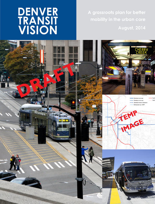
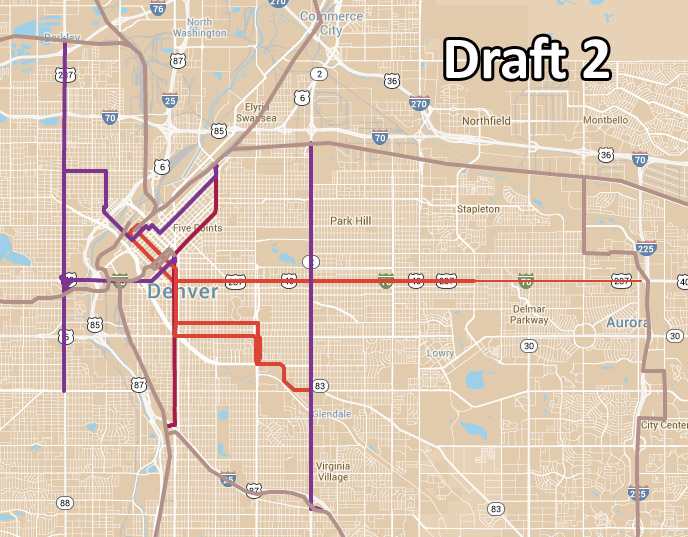
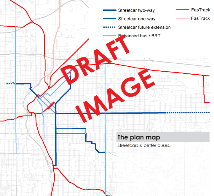
Since we still don't have good info on likely tax revenue, I'm moving forward anyway. I'm putting what we have into a short, graphics-heavy pdf report. It'll be about 8 pages cover to cover. When I have a draft, I'll share it here and ask for comments (on everything, including the final map, layout and prose of the report, data, etc).

THINGS I NEED NOW:

1. A nice high-res photo of a MetroRide bus in action. Preferably a few photos so I have options.

2. Some graphic representation of existing transitship in central Denver. A dot map that shows riders clustering along Broadway and Colfax would be perfect, but a bar chart showing ridership of bus routes might be an acceptable backup.

3. Thoughts on a title. I don't want to call it the "SSP Transit Plan," since "SSP" is meaningless to most people. I'm thinking instead "People's Transit Plan" but would like to hear other suggestions.

4. A list of contributor names. Unless people hate the idea, somewhere near the front of this report I will include a list of the names of people who have contributed. If you've commented in this thread that means you. I do not want to use forum names because that looks amateur. Should we do this or not? If we should, please respond here or PM your real name, so I can include it.

That's all for now. Probably there will be more later.

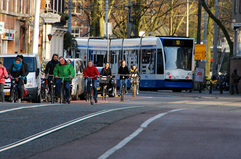
HERE'S A FUN PICTURE FOR YOUR TROUBLES:

You need some way to key direction, once you get raw data. The interesting bus ridership traffic map that Wong brought in is OK for starters, but what needs to be done, even on a close in basis, is show direction in those dots.

A minor example: At DUS Light rail, how many people are leaving Lodo and how many are arriving at Lodo at a given time- say 6:00p. Another metric might be related to how many people exit Civic Station and take shuttles and how many walk to work from Civic Station.

I am NOT anywhere near the photographer Ryan is. Why not ask him if he has photos of traffic at the 16th and Stout station (mornings) and California and 16th (4:30-5:30p). Sometimes California and Stout is packed.
__________________
Good read on relationship between increasing number of freeway lanes and traffic

http://www.vtpi.org/gentraf.pdf
Reply With Quote
     
     
  #164  
Old Posted Jul 7, 2014, 8:19 PM
wong21fr's Avatar
wong21fr wong21fr is offline
Reluctant Hobbesian
 
Join Date: Feb 2002
Location: Denver
Posts: 13,162
Quote:
Originally Posted by Wizened Variations View Post
You need some way to key direction, once you get raw data. The interesting bus ridership traffic map that Wong brought in is OK for starters, but what needs to be done, even on a close in basis, is show direction in those dots.

A minor example: At DUS Light rail, how many people are leaving Lodo and how many are arriving at Lodo at a given time- say 6:00p. Another metric might be related to how many people exit Civic Station and take shuttles and how many walk to work from Civic Station.

I am NOT anywhere near the photographer Ryan is. Why not ask him if he has photos of traffic at the 16th and Stout station (mornings) and California and 16th (4:30-5:30p). Sometimes California and Stout is packed.
That's too granular for the level of this idea. All you need are passenger counts at each stop on a daily level to show the overall ridership of these routes.
__________________
"You don't strike, you just go to work everyday and do your job real half-ass. That's the American way!" -Homer Simpson

All of us who are concerned for peace and triumph of reason and justice must be keenly aware how small an influence reason and honest good will exert upon events in the political field. ~Albert Einstein

Reply With Quote
     
     
  #165  
Old Posted Jul 7, 2014, 9:17 PM
RyanD's Avatar
RyanD RyanD is offline
Fast. Fun. Frequent.
 
Join Date: Aug 2010
Location: Denver, Colorado
Posts: 2,987
Quote:
Originally Posted by wong21fr View Post
That's too granular for the level of this idea. All you need are passenger counts at each stop on a daily level to show the overall ridership of these routes.
Hey man, if I need to do another time-lapse project, then I have to do another time-lapse project. If the bearded man in DC is shining a RD in the sky so I can see my calling, so be it.
__________________
DenverInfill
DenverUrbanism
--------------------
Latest Photo Threads: Los Angeles | New Orleans | Denver: 2014 Megathread | Denver Time-Lapse Project For more photos check out: My Website and My Flickr Photostream
Reply With Quote
     
     
  #166  
Old Posted Jul 7, 2014, 9:29 PM
wong21fr's Avatar
wong21fr wong21fr is offline
Reluctant Hobbesian
 
Join Date: Feb 2002
Location: Denver
Posts: 13,162
Quote:
Originally Posted by RyanD View Post
Hey man, if I need to do another time-lapse project, then I have to do another time-lapse project. If the bearded man in DC is shining a RD in the sky so I can see my calling, so be it.
Oh, I have no doubt that you'll do it. But I hardly think that the level of data visualization that Wizened is proposing is necessary for a project that amounts to a white paper on increasing transit connectivity and ease of use in Denver.
__________________
"You don't strike, you just go to work everyday and do your job real half-ass. That's the American way!" -Homer Simpson

All of us who are concerned for peace and triumph of reason and justice must be keenly aware how small an influence reason and honest good will exert upon events in the political field. ~Albert Einstein

Reply With Quote
     
     
  #167  
Old Posted Jul 8, 2014, 12:10 AM
Cirrus's Avatar
Cirrus Cirrus is offline
cities|transit|croissants
 
Join Date: Jul 2001
Location: Washington, DC
Posts: 18,378
Wong is right. We don't need that level of detail for this.
__________________
writing | twitter | flickr | instagram | ssp photo threads
Reply With Quote
     
     
  #168  
Old Posted Jul 8, 2014, 6:10 PM
Wizened Variations's Avatar
Wizened Variations Wizened Variations is offline
Registered User
 
Join Date: Apr 2008
Posts: 1,611
Quote:
Originally Posted by Cirrus View Post
Wong is right. We don't need that level of detail for this.
Just a matter of data mining, eh?
__________________
Good read on relationship between increasing number of freeway lanes and traffic

http://www.vtpi.org/gentraf.pdf
Reply With Quote
     
     
  #169  
Old Posted Aug 1, 2014, 8:47 PM
Cirrus's Avatar
Cirrus Cirrus is offline
cities|transit|croissants
 
Join Date: Jul 2001
Location: Washington, DC
Posts: 18,378
UPDATE
Now with a draft report


Clickity click (it's a pdf):


Remaining things to do:
  1. Finalize the routes and map them nicely. It's been so long since we talked about it that we'll want to go back and think about them carefully again. What I'm showing in the draft report here doesn't necessarily need to be what we use (in fact I assume we'll want some additions/subtractions).
  2. Proofread and suggest edits. All comments/suggestions are welcome. Don't hold back.
  3. Come up with something to put on the "how" page. Even if it's just ideas and not data, that's still better than nothing. So help me with ideas.
  4. Want your name on the author list? PM me. Real names only; no forum pseudonyms.
  5. Blog post on DenverInfill/DenverUrbanism.
  6. What else?
__________________
writing | twitter | flickr | instagram | ssp photo threads
Reply With Quote
     
     
  #170  
Old Posted Aug 1, 2014, 10:03 PM
RyanD's Avatar
RyanD RyanD is offline
Fast. Fun. Frequent.
 
Join Date: Aug 2010
Location: Denver, Colorado
Posts: 2,987
I love this. Here are my first thoughts upon a quick skim. (I'll really get into it this weekend)

Quote:
Originally Posted by Cirrus View Post
Remaining things to do:
  1. Finalize the routes and map them nicely. It's been so long since we talked about it that we'll want to go back and think about them carefully again. What I'm showing in the draft report here doesn't necessarily need to be what we use (in fact I assume we'll want some additions/subtractions).
  2. Proofread and suggest edits. All comments/suggestions are welcome. Don't hold back.

    Instead of We're the grassroots, you should say WE ARE the grassroots. Sounds more powerful imo. Same with the other we're statement.
  3. Come up with something to put on the "how" page. Even if it's just ideas and not data, that's still better than nothing. So help me with ideas.

    Ian Harwick had some interesting ideas he was throwing out at the urbanist meetup with this. I'll see if I can probe his brain for some written information.
  4. Want your name on the author list? PM me. Real names only; no forum pseudonyms.

    I'll put my name stamp down on the participants page
  5. Blog post on DenverInfill/DenverUrbanism.

    Obviously can help with that.
  6. What else?

    Let me know of any additional photos you need. Metroride is hard because I have to work during its time. But LRT, etc is super easy and I have a boat load of those transity photos.
__________________
DenverInfill
DenverUrbanism
--------------------
Latest Photo Threads: Los Angeles | New Orleans | Denver: 2014 Megathread | Denver Time-Lapse Project For more photos check out: My Website and My Flickr Photostream
Reply With Quote
     
     
  #171  
Old Posted Aug 5, 2014, 6:16 PM
RyanD's Avatar
RyanD RyanD is offline
Fast. Fun. Frequent.
 
Join Date: Aug 2010
Location: Denver, Colorado
Posts: 2,987
Can we get an email list going? It would be nice for people not on here to get involved.
__________________
DenverInfill
DenverUrbanism
--------------------
Latest Photo Threads: Los Angeles | New Orleans | Denver: 2014 Megathread | Denver Time-Lapse Project For more photos check out: My Website and My Flickr Photostream
Reply With Quote
     
     
  #172  
Old Posted Aug 5, 2014, 7:49 PM
Cirrus's Avatar
Cirrus Cirrus is offline
cities|transit|croissants
 
Join Date: Jul 2001
Location: Washington, DC
Posts: 18,378
Sure. Are you volunteering to run the email list?
__________________
writing | twitter | flickr | instagram | ssp photo threads
Reply With Quote
     
     
  #173  
Old Posted Aug 6, 2014, 3:53 PM
Wizened Variations's Avatar
Wizened Variations Wizened Variations is offline
Registered User
 
Join Date: Apr 2008
Posts: 1,611
If you do not put in a loop around downtown your plan will not fly, IMO. At least not on a metro level.
__________________
Good read on relationship between increasing number of freeway lanes and traffic

http://www.vtpi.org/gentraf.pdf
Reply With Quote
     
     
  #174  
Old Posted Aug 6, 2014, 4:06 PM
wong21fr's Avatar
wong21fr wong21fr is offline
Reluctant Hobbesian
 
Join Date: Feb 2002
Location: Denver
Posts: 13,162
Quote:
Originally Posted by Wizened Variations View Post
If you do not put in a loop around downtown your plan will not fly, IMO. At least not on a metro level.
This plan doesn't give a shit about the metro area. It's for the City of Denver and nothing more. No worries about any possible capacity issues on FasTrack lines, the DT loop capacity, through-lines at Union Station, etc. This is about improving transit on the most heavily traveled bus corridors, which just so happen to be in Denver.
__________________
"You don't strike, you just go to work everyday and do your job real half-ass. That's the American way!" -Homer Simpson

All of us who are concerned for peace and triumph of reason and justice must be keenly aware how small an influence reason and honest good will exert upon events in the political field. ~Albert Einstein

Reply With Quote
     
     
  #175  
Old Posted Aug 6, 2014, 4:15 PM
Wizened Variations's Avatar
Wizened Variations Wizened Variations is offline
Registered User
 
Join Date: Apr 2008
Posts: 1,611
Quote:
Originally Posted by wong21fr View Post
This plan doesn't give a shit about the metro area. It's for the City of Denver and nothing more. No worries about any possible capacity issues on FasTrack lines, the DT loop capacity, through-lines at Union Station, etc. This is about improving transit on the most heavily traveled bus corridors, which just so happen to be in Denver.
Still won't help much. Unless huge bucks are spent for subways and/or dedicated right-of-way, any such plan will barely make a dent.

The entire system has to work better. Put the loop through central Denver. Elevate it, and, that loop alone would carry as much traffic as all the steel rail that has been built or will be built under Fastraks.

I agree with Colfax and Colorado. The rest is just flourish.
__________________
Good read on relationship between increasing number of freeway lanes and traffic

http://www.vtpi.org/gentraf.pdf
Reply With Quote
     
     
  #176  
Old Posted Aug 30, 2014, 5:29 PM
Cirrus's Avatar
Cirrus Cirrus is offline
cities|transit|croissants
 
Join Date: Jul 2001
Location: Washington, DC
Posts: 18,378
LET'S TALK ROUTES ONE LAST TIME

I think this was our most recent map:


When prepping the draft pdf report above, I made some different choices just to see what they'd look like. Here's that:


What should we do?

We can pick one or the other map, or we can mix & match. This is your last chance to comment on routes so please give me your opinions about what should be in, what should be out, and what should be rail vs bus.
__________________
writing | twitter | flickr | instagram | ssp photo threads
Reply With Quote
     
     
  #177  
Old Posted Aug 30, 2014, 6:21 PM
bcp's Avatar
bcp bcp is offline
BANNED
 
Join Date: Jul 2001
Posts: 5,143
i like this second one more...but the route through DT looks excruciatingly painful for riders (it doesn't have to hit DUS, does it?)...can you straighten that out, as well as straighten the CC portion?
Reply With Quote
     
     
  #178  
Old Posted Aug 30, 2014, 8:05 PM
bunt_q's Avatar
bunt_q bunt_q is offline
Provincial Bumpkin
 
Join Date: Aug 2002
Location: Denver, CO
Posts: 13,203
I still think bidirectional down 15th through downtown. We can make the space. And if the light rail is close enough to union station now, then 15th is also close enough.

The 15th/17th bus couplet should be moved to 17th/18th anyways.

Make 14th a two way street and you've helped with the auto circulation.
Reply With Quote
     
     
  #179  
Old Posted Aug 31, 2014, 5:33 AM
jimluka jimluka is offline
Registered User
 
Join Date: Aug 2014
Posts: 4
  • I like the idea of the Larimer to Sante Fe line, but I worry that it is too redundant falling between the Central Corridor/Broadway lines.
  • If a Larimer/Sante Fe line is done, it sacrifices too much to get to DUS, I also don't think the portion along Speer serves any riders at all. Perhaps a straight shot down Larimer through campus to Auraria West then a quick jaunt down Colfax to Sante Fe/Kalamath couplet(not currently shown)
  • I think it might make sense to end the Sante Fe line on the west side of the tracks at Alameda(behind Home Depot) rather than at 2nd/3rd as currently shown. I once heard a rumor that Greyhound wanted to move their station here, which might provide potential synergies, either way maybe the ped bridge finally gets built and that land becomes more attractive.
  • Better yet, the Larimer line runs through Auraria to Auraria West, the Walnut St underpass becomes BRT only and the line continues to Federal-Decatur before splitting North/South.

  • I agree with bunt, lose the couplet downtown and go both ways on 15th

  • Politically it might be a good idea to not show a potential future "incursion" into Highland Square, they are a bit touchy up there.

  • Also might be a good idea to shepherd the Boulder bus all the way into DUS.

  • Just spitballing but what if the CC line was BRT and just ran Speer to 1st all the way over to Colorado.
Reply With Quote
     
     
  #180  
Old Posted Aug 31, 2014, 7:08 AM
Zmapper Zmapper is offline
Registered User
 
Join Date: May 2012
Posts: 210
Colfax/Speer/Kalamath is a traffic disaster, with complicated signal phasing and no easy fix. Any solid transit plan would avoid to the extent possible routing any transit through that intersection without guaranteed transit-only lanes, which are unfeasible for the reasons below.

In particular, the turn northbound Kalamath to westbound Speer will be incredibly challenging. The transit vehicle will most probably need to stop at Colfax; in order to accommodate the space and turning dimensions of Kalamath, and for pedestrian safety, the stop will likely have to be curbside. The vehicle will either need to fight its way across three lanes. During peak hours, those lanes will be congested; off-peak, multiple left lateral lane changes on a rightward-curving road will be incredibly challenging for the transit operator, who will not be able to use the left mirror (the transit vehicle blocks viewing the relevant traffic), and does not have the luxury of glancing over their shoulder like a car driver does.

An option may be to have the transit vehicle remain in the curb lane until Speer, and turn left from the curb lane with the help of a signal. Two challenges exist; the NB Kalamath bridge over Cherry Creek is four lanes, two left, two straight. The signal phasing precludes combining the lanes into three - left, both, through - as the left turn movement conflicts with the light rail and needs signalized exclusion. At this point, a new NB bridge with five lanes would be needed. The other issue is with the signal phasing; a transit-only left-turn cycle could be combined with the NB left-turn cycle by directing traffic into the left two lanes, but then drivers would attempt to merge right, crossing the transit vehicle, to access the Convention Center parking garage.

Note that the existing Route 1, nor any other route, turns left at this intersection.

In short, the route in its present form is dead on arrival.
Reply With Quote
     
     
This discussion thread continues

Use the page links to the lower-right to go to the next page for additional posts
 
 
Reply

Go Back   SkyscraperPage Forum > Regional Sections > United States > Mountain West
Forum Jump


Thread Tools
Display Modes

Forum Jump


All times are GMT. The time now is 6:56 AM.

     
SkyscraperPage.com - Archive - Privacy Statement - Top

Powered by vBulletin® Version 3.8.7
Copyright ©2000 - 2024, vBulletin Solutions, Inc.