HomeDiagramsDatabaseMapsForum About
     

Go Back   SkyscraperPage Forum > Photography Forums > Found City Photos

Reply

 
Thread Tools Display Modes
     
     
  #18001  
Old Posted Dec 3, 2013, 5:21 AM
Matthew's Avatar
Matthew Matthew is offline
Fourth and Main
 
Join Date: Feb 2002
Location: Johns Creek, GA (Atlanta)
Posts: 3,135
The real mystery for me was: What does Monkey Island look like? Photographs are so rare. I've only seen a photograph of the entrance (I think there are two from that same day?) and the 1948 aerial. All of the other images of Monkey Island are illustrations. I find this very unusual for a tourist attraction. I'm surprised by the lack of photographs/videos taken by visitors or photographs of celebrities visiting. The design may have changed from the rendering, as I look at the entrance photograph, but I do hope it looked very close to that rendering. I love that design. Maybe someone can use a directory to see what restaurants located there and how long they remained?
__________________
My Diagram
Reply With Quote
     
     
  #18002  
Old Posted Dec 3, 2013, 8:51 AM
GatoVerde's Avatar
GatoVerde GatoVerde is offline
Registered User
 
Join Date: Dec 2013
Location: Los Angeles
Posts: 110
Clune's Auditorium

Quote:
Originally Posted by sopas ej View Post
Really nice pics, ethereal!

The State Normal School was on the site that is now occupied by the main branch of the Los Angeles Public Library. The Normal School evolved into what became UCLA.

That auditorium-- my guess is that it's the back part of the now demolished Philharmonic Auditorium/Clune's Auditorium, which used to face Pershing Square. That site has been long vacant (since the mid-1980s); if the plans still haven't fallen through, it's the future site of the development called Park Fifth.
This image from lapl appears show the same back wall with turrets.


Last edited by GatoVerde; Dec 3, 2013 at 9:39 AM.
Reply With Quote
     
     
  #18003  
Old Posted Dec 3, 2013, 9:32 AM
GatoVerde's Avatar
GatoVerde GatoVerde is offline
Registered User
 
Join Date: Dec 2013
Location: Los Angeles
Posts: 110
Last remnant of railway


Last edited by GatoVerde; Dec 3, 2013 at 9:47 AM.
Reply With Quote
     
     
  #18004  
Old Posted Dec 3, 2013, 10:17 AM
GatoVerde's Avatar
GatoVerde GatoVerde is offline
Registered User
 
Join Date: Dec 2013
Location: Los Angeles
Posts: 110
Cyclorama

I wonder what happened to the paintings.

Panorama Rotunda at Third and Main Streets in Los Angeles, late 1880s - seen from the rear.


This photo is from this site which provides more info on the cyclorama.

http://www.panoramaonview.org/panora...geofparis.html


usc digital archive
Reply With Quote
     
     
  #18005  
Old Posted Dec 3, 2013, 10:35 AM
GatoVerde's Avatar
GatoVerde GatoVerde is offline
Registered User
 
Join Date: Dec 2013
Location: Los Angeles
Posts: 110
Bella Union / Carlisle gunfight

Quote:
Originally Posted by ethereal_reality View Post
Here's an intriguing photograph of the Bella Union Hotel in 1871.
It looks like a Bank of Los Angeles is next door.


usc digital archive
http://www.historynet.com/shootout-i...nion-hotel.htm

Carlisle interrupted a wedding party for Solomon Lazard and Joseph Newmark's daughter. Carlisle was killed by future civic leaders and buried at the City Cemetery on top of Fort Moore. Grave robbers stole the two diamonds he had in his front teeth. His grave was later moved to Rose Hills.
Reply With Quote
     
     
  #18006  
Old Posted Dec 3, 2013, 10:45 AM
GatoVerde's Avatar
GatoVerde GatoVerde is offline
Registered User
 
Join Date: Dec 2013
Location: Los Angeles
Posts: 110
Quote:
Originally Posted by ethereal_reality View Post
Below: Looking east from the Crocker Mansion 1898. I think this photograph is exceptional.

What is the huge building on the distant horizon?


usc ditial archive


I just noticed what might be a cyclorama on the right hand side.
I recognize City Hall, but a couple of the other prominent buildings are a mystery to me.
I believe the building in the distant horizon is the Sisters of Charity's second orphanage located in Boyle Heights, at Stephenson (now Whittier Blvd.) and Boyle Avenue. The first site for the orphanage is close to where Terminal Annex is now.
Reply With Quote
     
     
  #18007  
Old Posted Dec 3, 2013, 11:02 AM
GatoVerde's Avatar
GatoVerde GatoVerde is offline
Registered User
 
Join Date: Dec 2013
Location: Los Angeles
Posts: 110
Vignes Winery, early site for Brew 102 and home of sacred Gabrielino council Tree

Quote:
Originally Posted by ethereal_reality View Post
^^^Here is a photograph showing the Brew 102 Building Sopas_ej. It was taken from the top of City Hall in 1952.


usc digital archive
Early image showing Vignes Winery, early site for Brew 102 and home of sacred Gabrielino council Tree later known as El Alisal (from this website:http://www.kcet.org/updaily/socal_fo...a-history.html) The image is looking east from Fort Hill, shows the plaza cistern in the lower left and the Vignes site and council tree are in the middle right, site of the later brewery.

Reply With Quote
     
     
  #18008  
Old Posted Dec 3, 2013, 11:20 AM
GatoVerde's Avatar
GatoVerde GatoVerde is offline
Registered User
 
Join Date: Dec 2013
Location: Los Angeles
Posts: 110
Pound Cake Hill

Quote:
Originally Posted by ethereal_reality View Post


In the first photograph I recognized Los Angeles' first High School as the white building with the cupola on the far left hand side of the pic.
But it didn't seem to be in the right location.


usc digital archive

Above: Los Angeles High School on Fort Moore Hill.


usc digital archive


usc digital archive


I was confused until I found the next two photographs.


usc digital archive


usc digital archive


They moved the damn thing!


Do any of you in Los Angeles know the story behind this?
The first two photos are of the first LA High on Pound Cake Hill, before it was moved, not Fort Hill. When they moved it to Fort Moore they ran into a snag and it sat on the the top of Temple for a while. I think the cupola you note is St. Vibiana. The school was moved to clear the site for the building of the courthouse which stood on Temple and Broadway, site of the current Clara Foltz court building. Very, very little (nothing) of the original Pound Cake Hill remains.

Last edited by GatoVerde; Dec 3, 2013 at 11:29 AM. Reason: Added more info.
Reply With Quote
     
     
  #18009  
Old Posted Dec 3, 2013, 11:48 AM
GatoVerde's Avatar
GatoVerde GatoVerde is offline
Registered User
 
Join Date: Dec 2013
Location: Los Angeles
Posts: 110
Quote:
Originally Posted by ethereal_reality View Post
Earlier, I forgot to post this photograph of the old High School and it one of the best.
Here it sits proudly on the hill.

There is one other reason I wanted to post it.
I've been intrigued by the rather large elongated/horizontal building
in the distance. It almost looks like a train shed or livery stables.
Whatever it is, it's quite impressive for this early date.

Does anyone know what it is? Scott, Beaudry, Sopas_ej, GayloreWilshire?


usc digital archive
The image is from Fort Hill looking SE over Pound Cake Hill. The building might be the Arcade Depot on Alameda:
(from website: http://waterandpower.org/museum/Earl...s)_Page_4.html)
Reply With Quote
     
     
  #18010  
Old Posted Dec 3, 2013, 12:30 PM
GatoVerde's Avatar
GatoVerde GatoVerde is offline
Registered User
 
Join Date: Dec 2013
Location: Los Angeles
Posts: 110
Quote:
Originally Posted by ethereal_reality View Post
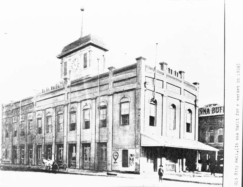
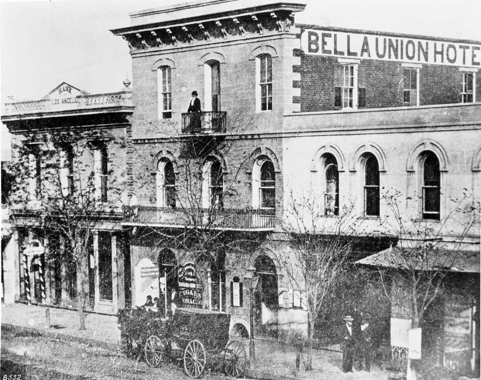
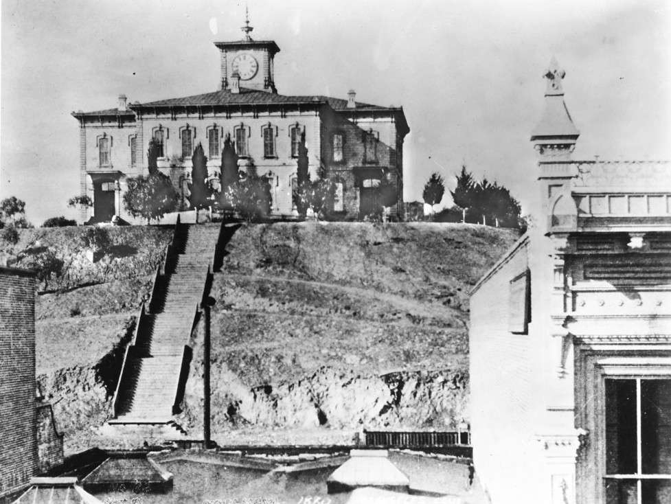
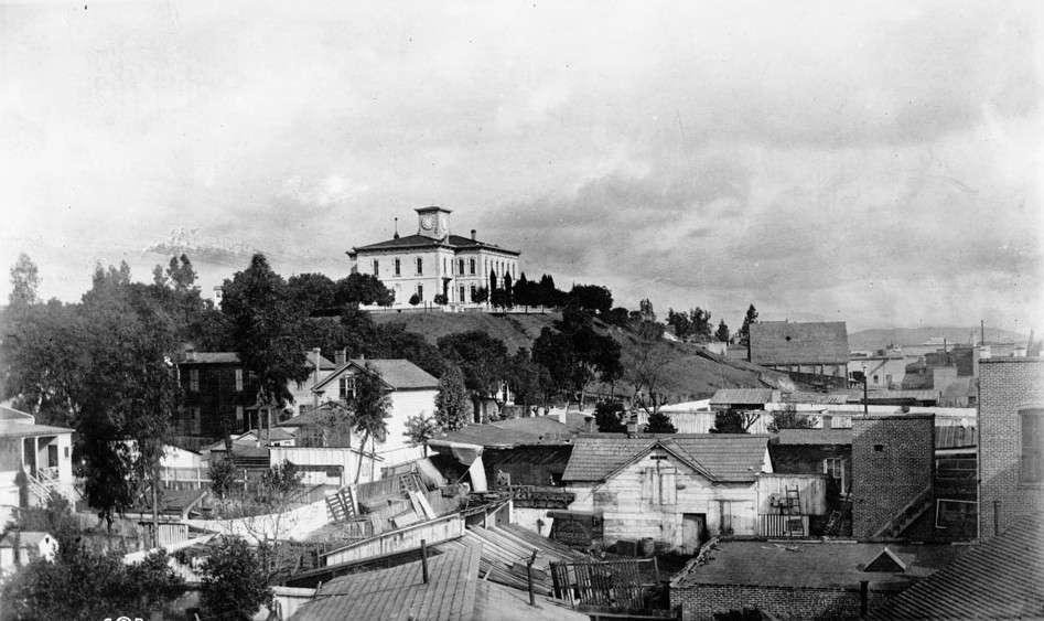
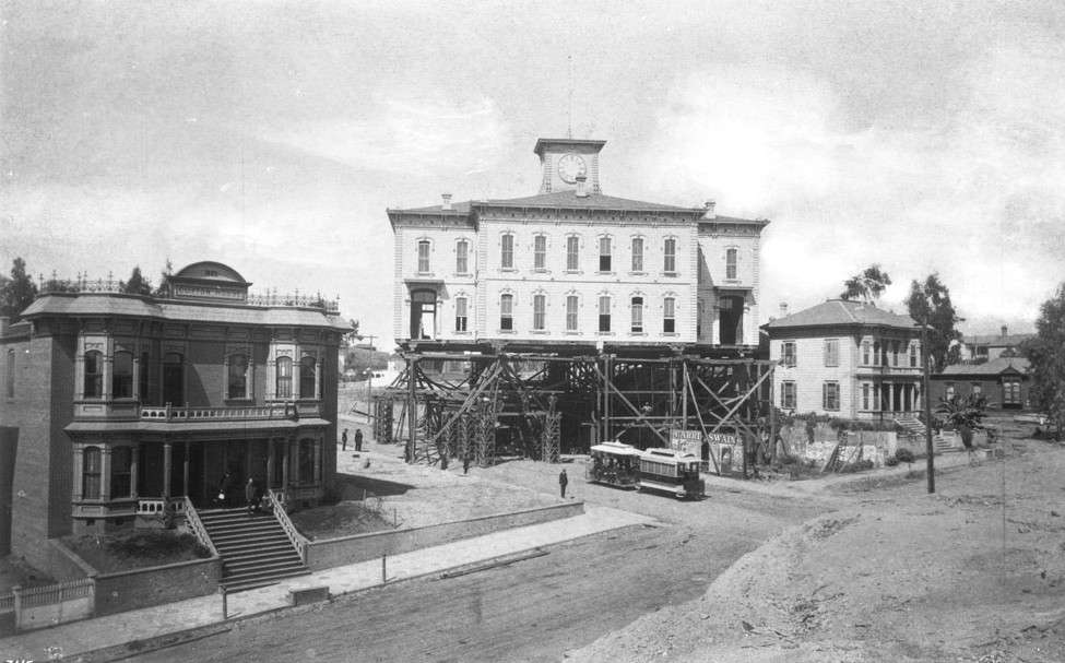
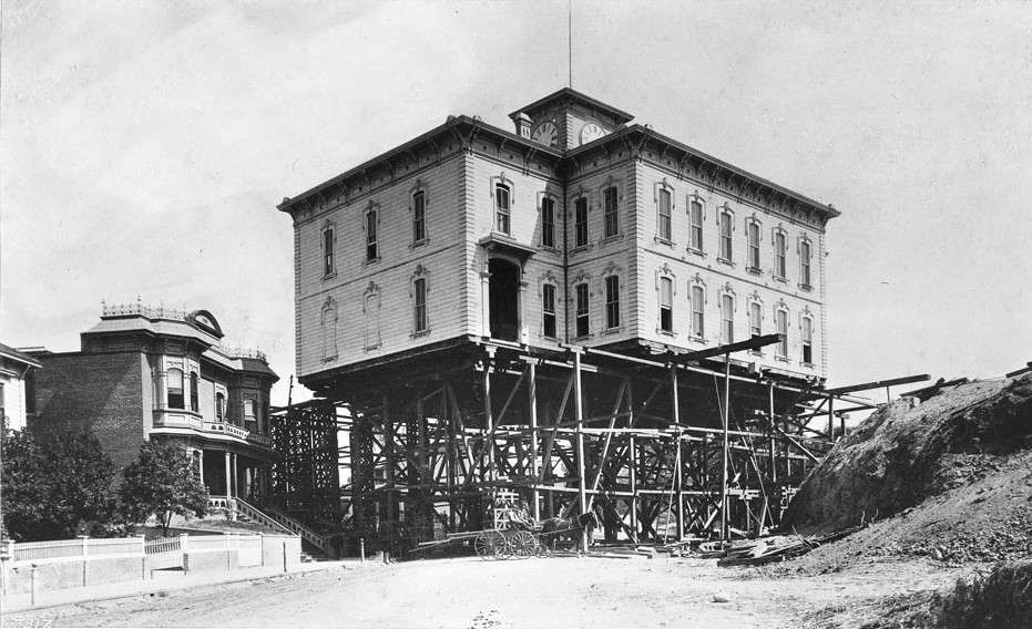
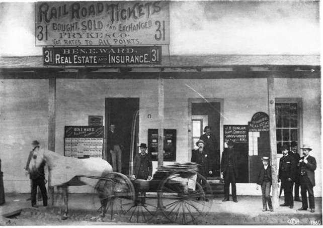
Built in 1858 as a market, this building became Los Angeles' 1st City Hall.


usc digital archive


usc digital archive


usc digital archive


Around this time, the usc archive starts labeling it the Temple Building.
At first I thought it was just a mistake (there are many photos mislabeled in the archive).


usc digital library


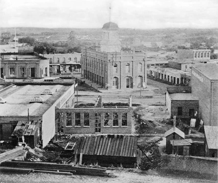
But then I came across this photograph from 1885.


usc archive


So...I take it, the 1st city hall (or court house as it's often labeled)
was, over the years, enveloped by surrounding buildings that eventually
created the Temple block.

Is this correct?
From LAPL Photo Collection:

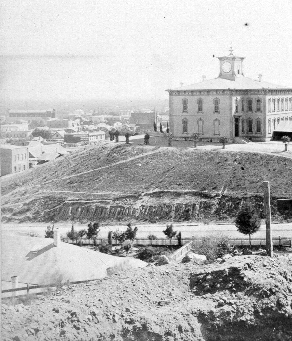
I believe there was an earlier, American, city hall located at to the left of this hanging site. This image is the hanging of Michael Lachenais on December 17, 1870. It is looking West from near Spring and Temple towards Fort Hill which ran all the way down to Spring. I believe building on the left housed the first stage services in the city and also the first American city council. Can someone confirm or deny?

This is from Harris Newmark, Sixty Years in Southern California, ch. 4, p.36.
http://memory.loc.gov/cgi-bin/query/...albk023%29%29:

"The administrative officials of both the City and the County had their headquarters in the one-story adobe building at the northwest corner of Franklin Alley (later called Jail Street* ) and Spring Street. In addition to those mentioned, there was a Justice of the Peace, a Zanjero, and a Jailer. António Franco Coronel had but recently succeeded Nichols as Mayor; A. S. Beard was Marshal and Tax Collector; Judge William G. Dryden was Clerk; C. E. Carr was Attorney; Ygnácio Coronel was Assessor; and S. Arbuckle was Treasurer.

[Note : In April, 1872, officially named Franklin Street.]

António Franco Coronel, after whom Coronel Street is named, had just entered upon the duties of Mayor, and was busy enough with the disposal of donation lots when I first commenced to observe Los Angeles' government. He came from Mexico to California with his father, Don Ygnácio F. Coronel; and by 1850 he was the first County Assessor. He lived at what is now Alameda and Seventh streets, and had a brother, Manuel, who was City Assessor in 1858."
Reply With Quote
     
     
  #18011  
Old Posted Dec 3, 2013, 3:17 PM
ethereal_reality's Avatar
ethereal_reality ethereal_reality is offline
Registered User
 
Join Date: Feb 2008
Location: Lafayette/West Lafayette IN, Purdue U.
Posts: 16,350
Excellent information GatoVerde! Welcome to the thread.
Reply With Quote
     
     
  #18012  
Old Posted Dec 3, 2013, 3:58 PM
CityBoyDoug CityBoyDoug is offline
BANNED
 
Join Date: Apr 2013
Posts: 2,868
Monkey Island....

Quote:
Originally Posted by Martin Pal View Post
Well, E_R, I hope the palpitations are worth it!
…the mysterious “Monkey Island” opened 75 years ago…
Feeding time at Monkey Island. [lower left]

As for the restaurant, I'll skip that as ER says and meet you for a sandwich at Musso & Frank's.


Reply With Quote
     
     
  #18013  
Old Posted Dec 3, 2013, 4:50 PM
ProphetM ProphetM is offline
Registered User
 
Join Date: Jul 2012
Posts: 440
Here is another photo of Monkey Island with an angle I hadn't seen before:


Circus Anonymous
Reply With Quote
     
     
  #18014  
Old Posted Dec 3, 2013, 5:10 PM
HossC's Avatar
HossC HossC is offline
Registered User
 
Join Date: Aug 2013
Posts: 4,245
Yesterday, Martin Pal posted a link to a 1938 edition of Pacific Electric Magazine with a picture of Monkey Island. On the following page there's an article about the proposed Aliso Street viaduct. It gives many of the measurements and the amount of railroad traffic on the lines it had to cross:

Quote:
Construction of the Aliso street viaduct across the Los Angeles River, Santa Fe tracks and a number of streets, from Vignes street to the intersection of Mission Road and Aliso street, for which City Engineer Aldrich is seeking federal funds in Washington, D. C., will be of tremendous value in reducing traffic hazards as well as providing traffic convenience, various authorities declare.

The plans call for the Pacific Electric trains operating overhead across the entire sector of Mission Road and the north roadway of Aliso street to a private right of way, it is pointed out.

Elimination of the grade crossing means that 573 Pacific Electric trains of one or more cars in sixteen hours of each day would no longer be interfered with and a great traffic menace would be removed.

The viaduct passes over Santa Fe and Union Pacific tracks carrying sixty-nine Union Pacific and thirty-six Santa Fe trains daily, some of them lengthy freight trains. After completion of the new Union Passenger Terminal, Union Pacific train movements will be increased to 138 trains a day and the viaduct will carry traffic freely over them all. Another advantage of the viaduct pointed out by the proponents is that it eliminates the jams caused by the increase of motor vehicles and trains at the peak traffic hours in the morning and the evening.

The viaduct itself will be 1895 feet long and 105 wide for its entire length. At the west approach, the vehicular roadway will be fifty-six feet in width. Crossing the river the roadway will flare from the west bank to a width of 105 feet at the east line, because at the point it goes through a divided roadway in order to permit the Pacific Electric line to remain overhead in the center of the structure.

Both east and west approaches to the viaduct will consist of reinforced concrete slab spans with curved soffits. A single span is used to cross the river and will consist of a twohinged steel arch, clearing the 212½ foot channel planned for the river at that point by United States Army engineers.

In order to further eliminate crossings at grade, a slot is to be provided in the center of Mission Road, permitting through traffic on the road to pass under Aliso street. The bridge will have divided vehicular roadways, each to be twenty-eight feet wide. There will be a six-foot sidewalk for pedestrians on each side of the roadways. - Pacific Electric Magazine
The article was accompanied by this picture:


libraryarchives.metro.net (PDF file)

I found this drawing, dated 1937, on the LAPL site. The description says: "This drawing published in February 1939 shows the plan for the two-million-dollar Aliso Street grade separation and viaduct over the Los Angeles River to get underway shortly. The State Highway Commission and Councilman Stephen Cunningham reported that the state is ready to contribute $220,000 provided the city and county contribute a like amount. The railroads had already pledged $450,000 as their share. Councilman Cunningham declared the Public Works Administration probably would appropriate $906,000. The plan, approved by city engineer Lloyd Aldlrich, is dated May 21, 1937. The Macy Street bridge is seen in the background."


lapl.org

The diagrams are slightly vague, but both make it look as if the original plan was for all road traffic to enter/leave the east side of the viaduct at Mission Road.

The USC Library has a couple of photos of Aliso Street crossing the Los Angeles River shortly before the construction on the viaduct began.

"View of site of Aliso Street viaduct prior to construction of new bridge, looking west from point about 300 feet east of Mission Road, Los Angeles, 1940."


USC Digital Library

"View along Los Angeles River from Macy Street bridge, Los Angeles, 1940."


USC Digital Library

This image from the LAPL archive is dated 1942, despite what the caption says!

"The Aliso Street Bridge is being built over the Los Angeles River on March 28, 1947 [sic], with train tracks in the foreground."


lapl.org

This aerial shot clearly shows the finished roadway extending east of Mission Road. The caption implies that the cost of the viaduct had doubled by its completion.

"The new Aliso Street Bridge completed on July 24, 1944. An impressive program was scheduled for the opening of the $4,000,000 bridge."


lapl.org

Both diagrams, and the PE Magazine article, suggest that the original plans included a tunnel on Mission Road that went under Aliso Street. The picture below shows that the tunnel was never built. The white building on the left is still there, although it's now painted orange.

"View of the Mission Road span of the Aliso Street viaduct on December 20, 1944, looking north from 150 feet south of Aliso Street."


lapl.org
Reply With Quote
     
     
  #18015  
Old Posted Dec 3, 2013, 5:39 PM
Wig-Wag's Avatar
Wig-Wag Wig-Wag is offline
Registered User
 
Join Date: Feb 2012
Posts: 330
Arcade Station

See corrected post below.

Cheers,
Jack

Last edited by Wig-Wag; Dec 3, 2013 at 6:03 PM. Reason: Additional Information/corrections
Reply With Quote
     
     
  #18016  
Old Posted Dec 3, 2013, 5:43 PM
Wig-Wag's Avatar
Wig-Wag Wig-Wag is offline
Registered User
 
Join Date: Feb 2012
Posts: 330
Arcade Station

Quote:
Originally Posted by GatoVerde View Post
The building might be the Arcade Depot on Alameda:
(from website: http://waterandpower.org/museum/Earl...s)_Page_4.html)
GatoVerde, this is indeed the Southern Pacific Arcade Depot and we can probably date the photo between as having been taken between 1888, the year the station was built and 1890 based on the condition of the locomotive in the foreground.

No. 1384 is still in almost factory new condition, the easily damaged brass coverings on her cylinders and steam chests are still shiny and un-dented. She was the third of twenty rugged 4-4-0’s (4 wheels under the cylinders and 4 driving wheels) built for the SP of California by the Rogers Locomotive Works of Patterson, New Jersey in October of 1888. In the photo she is still a coal burner, but will be converted to oil fuel at Sacramento in July of 1907 when Southern California oil production reaches it’s full stride. Initially an LA based locomotive, she will end her days in the Pacific Nortrhwest, be vacated from the SP roster on January 31, 1925 and cut up for scrap at Portland, Oregon on October 30, 1926.

Last edited by Wig-Wag; Dec 3, 2013 at 10:14 PM. Reason: Additional Information/corrections
Reply With Quote
     
     
  #18017  
Old Posted Dec 3, 2013, 6:50 PM
kznyc2k's Avatar
kznyc2k kznyc2k is offline
Registered User
 
Join Date: Apr 2005
Location: Back to Boston
Posts: 1,865
Quote:
Originally Posted by ethereal_reality View Post
Chiaroscuro could be considered an appropriate term.

definition-
:pictorial representation in terms of light and shade without regard to color.

:the quality of being veiled or partly in shadow.

-more definitions here:
http://www.merriam-webster.com/dictionary/chiaroscuro

I have loved this word since my art history courses in college. It's seldom used to describe film, but it should be.
I'm 100% with you. Funny enough, it was the director of photography (John Alonzo) for my favorite movie, Chinatown, who taught me the word when someone described his look for it to be chiaroscuro but with an emphasis on the sun instead of shadows as noir movies are wont to do.

And coincidentally enough, it turns out that the DP behind my second favorite movie, Scarface, is the same guy! Similar visual style and all but I had no idea of this until well after I fell in love with either of them. Guess I really like this John Alonzo guy, and I know for a fact that I love chiaroscuro!
__________________
Politicians, ugly buildings and whores all get respectable if they last long enough.
Reply With Quote
     
     
  #18018  
Old Posted Dec 3, 2013, 9:16 PM
Lwize Lwize is offline
Registered User
 
Join Date: Aug 2012
Location: Los Angeles
Posts: 464
Hidden Downtown Courtyard Revealed

http://www.laobserved.com/archive/20..._courtyard.php

original story:

http://brighamyen.com/2013/12/02/dow...ng-early-2014/

Quote:
This past February, we discovered that an actual historic courtyard was “hidden” at the PacMutual building since post-WWII when it was covered up with a one-story building that was most recently a Verizon authorized retailer. The courtyard was created when the original 1908 PacMutual at 6th/Olive expanded with the addition of a much larger 1921 structure that most people now associate as being the main building (there are a total of three historic buildings that comprise the PacMutual). After the PacMutual was purchased by Rising Realty Partners back in April 2012, the urban-conscious developers have been actively repositioning the building with the goal of activating the community surrounding it.

Now the courtyard is finally revealed as seen in the pictures taken last week after the one-story structure was demolished and removed. The courtyard will become the shared outdoor patio dining space for Tender Greens and Le Pain Quotidien (LPQ), which are both now under construction. In addition, there will be a new entrance into the PacMutual lobby space from the courtyard.

The Belgian bakery, Le Pain Quotidien, is slated to open on Jan 15, 2014 (the same day as the grand opening of Ace Hotel at 9th/Broadway). The very popular Tender Greens, originally from Culver City, is a bit delayed and will be opening in late Feb.

(brighamyen.com)


(brighamyen.com)


(brighamyen.com)
Reply With Quote
     
     
  #18019  
Old Posted Dec 3, 2013, 10:26 PM
GatoVerde's Avatar
GatoVerde GatoVerde is offline
Registered User
 
Join Date: Dec 2013
Location: Los Angeles
Posts: 110
I think this might be the adobe to the left (South) of the courtyard showing the hanging of Lachenais.

The photo was taken from an earlier post by user Flyingwedge. The source for the photo is http://digitallibrary.usc.edu/cdm/re...oll65/id/14083

Last edited by GatoVerde; Dec 3, 2013 at 10:30 PM. Reason: adding source
Reply With Quote
     
     
  #18020  
Old Posted Dec 3, 2013, 10:37 PM
GatoVerde's Avatar
GatoVerde GatoVerde is offline
Registered User
 
Join Date: Dec 2013
Location: Los Angeles
Posts: 110
Damien Marchessault

Quote:
Originally Posted by Flyingwedge View Post
Marchessault (the street) was named to honor Marchessault (the mayor) after his death. He was a founder of the first city-owned gas company, and the first gas streetlights were installed during his tenure. He is also credited with helping establish Drum Barracks in Wilmington.

Damien Marchessault was born in Canada in 1818. He came to Los Angeles about 1850 and went into partnership with Victor Beaudry (Prudent's younger brother) bringing ice to LA from the San Bernardino Mountains. Marchessault served as Los Angeles Mayor from 1859-60 and 1861-65. In 1866-67 he was LA's Water Overseer, was again mayor for four months in 1867, then resumed his duties as Water Overseer.

Marchessault planned to install a system of pipes to deliver water to the city. But he gave the contract to a business associate, which prompted charges of corruption, and the pipes, made of hollowed-out trees, often leaked or even exploded, which prompted charges of incompetence.

The problems with the pipes -- along with bad business investments, gambling debts, and excessive drinking -- took their toll. Early in the morning of January 20, 1868, Marchessault went to the empty LA City Council Chambers, wrote his wife a suicide note (reproduced at link below), and shot himself in the head.

No photograph of Damien Marchessault is known to exist, but here's a photo of LA's first City Hall at Spring and Franklin in its later guise as a railroad ticket and real estate office:

USC Digital (http://digitallibrary.usc.edu/cdm/si...d/14083/rec/10)

Damien Marchessault bio from "If City Hall’s Walls Could Talk: Strange and Funny Stories from Inside Los Angeles City Hall," by Greig Smith (Xlibris Corporation 2010): http://books.google.com/books?id=7D5...page&q&f=false
I've often wondered which council chambers was the site of Damien Marchessault tragedy. I am still not clear if it took place at the first City Hall at stage coach adobe, or the second one at what later became the Temple Block. That second site was built in 1858 as a market but not used as a city hall until roughly ten years later which is roughly the time of the Marchessault suicide. Perhaps someone knows the exact date of occupancy at the second city hall (Temple Block) and can help resolve the question of where the Marchessault suicide actually took place.
Reply With Quote
     
     
This discussion thread continues

Use the page links to the lower-right to go to the next page for additional posts

Reply

Go Back   SkyscraperPage Forum > Photography Forums > Found City Photos
Forum Jump


Forum Jump


All times are GMT. The time now is 12:44 PM.

     
SkyscraperPage.com - Archive - Privacy Statement - Top

Powered by vBulletin® Version 3.8.7
Copyright ©2000 - 2024, vBulletin Solutions, Inc.