HomeDiagramsDatabaseMapsForum About
     

Go Back   SkyscraperPage Forum > Regional Sections > United States > Midwest


Reply

 
Thread Tools Display Modes
     
     
  #1  
Old Posted Dec 26, 2013, 9:45 AM
LMich's Avatar
LMich LMich is offline
Midwest Moderator - Editor
 
Join Date: Jan 2002
Location: Big Mitten
Posts: 31,745
Forgotten Detroit: Ford Freeway (I-94) Express Bus Stops

So, while looking up some history on Five Points Street I came across detroittransithistory.info, which I basically stumble over once or twice a year. It's basically the best (and really only) website detailing Detroit's transit history. A little cluttered and sometimes difficult to navigate, it's easy to get lost in.

I came across something I never knew existed, even though there is some evidence staring you right in the face: 
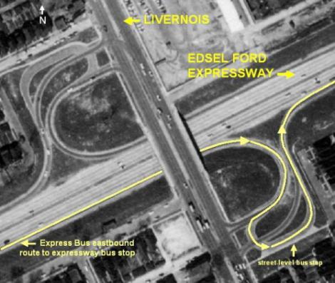
bus stops on the Ford Freeway that were supposed to be used for an express bus line that traveled the freeway. These Ford Freeway bus stops (at street-level along Livernois, and freeway-level at Woodward) were actually a compromise upon the building of the freeway in the mid-40's to early-50's. The original plan - the 1945 Detroit Expressway and Transit System by the Detroit Transportation Board - was to include rapid transit within the median of the Ford Freeway, but since Detroit was already into taking up streetcar lines since the 30's, the plan would have also changed most of the streetcar lines along the "spokes" to electric trolley-buses and express buses. At downtown, however, the trolley-buses and existing streetcar lines would have been a subway with some stops terminating under Cadillac Square.

Anyway, the DSR (Department of Street Railways, the precursor to DDOT), ultimately killed this plan in favor of the plan for express bus stops on the Ford. The service that would use at least one of these stops was the Plymouth Express in 1955. The stop was at Livernois and the Ford:


(WSU / DTE Aerial Photo Collection)

The eastbound stop is shown, but the westbound stop can be seen in the larger ramps on the north side of the interchange. Both bus stops/ramps have long since been removed. There was also a stop at Grand River and the Ford that was removed back in the 70's and a Gratiot stop along the freeway that was never used.

The most notable, though, and the one where the infrastructure is actually still visible is the Woodward stop. It was the only of these stops at freeway-level.


(MDOT)


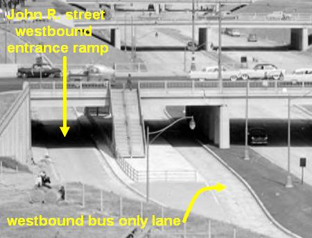
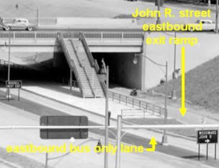
The problem was that the stop was built for an express service that never materialized. The Plymouth Limited, which was mentioned above, turned off at the Lodge to take you downtown, so it never used the stops, either. Built in 1955, by 1960, the DSR demolished them admitting that ridership was already declining and they couldn't justify the new service. Along with the staircases, the westbound station and ramp (north) were subsumed into a wider auto entrance ramp. However, the eastbound station and ramp (south) remain, abandoned, but they remain:


BTW, Detroit proper's last express route (at least to use the freeways) was #78 Imperial Limited, cancelled during the great blood letting of early 2012, when the management of the DDOT was farmed out to Parsons Brinckerhoff, who then farmed it out to the guy that ran Rochester's mass transit authority.

It's funny how you can drive by something multiple times and look at it and never see it. lol This is also a great storing in showing how early Detroit's transit planning turned into a nightmare. It also makes you wonder about what could be, and if proper funding could bring back something as simple as express bus service...
__________________
Where the trees are the right height
Reply With Quote
     
     
  #2  
Old Posted Dec 29, 2013, 6:36 PM
ardecila's Avatar
ardecila ardecila is offline
TL;DR
 
Join Date: Jun 2006
Location: the city o'wind
Posts: 16,365
Interesting. Amazing that the regional transit ambitions of a vast city were reduced down to a pair of staircases on a freeway overpass, and even those were never used as intended.

I believe Detroit pioneered the concept of transit lines in freeway medians along with Los Angeles, even though Chicago was ultimately the city that built them en masse. Funny to think how the city's destiny would have changed with a regional transit network connecting urban dwellers to jobs.
__________________
la forme d'une ville change plus vite, hélas! que le coeur d'un mortel...

Last edited by ardecila; Dec 29, 2013 at 6:47 PM.
Reply With Quote
     
     
  #3  
Old Posted Dec 30, 2013, 9:34 AM
LMich's Avatar
LMich LMich is offline
Midwest Moderator - Editor
 
Join Date: Jan 2002
Location: Big Mitten
Posts: 31,745
It's funny, even as late as the late 70's/early 80's, Metro Detroit was still developing plans for a Woodward Avenue subway and rapid-transit system up the spoke avenues. In fact, that's what the Detroit People Mover was built for, but it was the only part of the regional plan ever built, and then only after the city took over the project from the regional transit authority because they mismanaged it so badly.

What ultimately happened is that the regional transit authority (SEMTA) could never find stable funding, because the legislation which set it up in the 60's didn't provide for anything stable, and then the timing was horrible as the city was emptying out pressing downward on ridership. Everything either was botched and/or too late. That's the story of Detroit's regional transit.
__________________
Where the trees are the right height
Reply With Quote
     
     
  #4  
Old Posted Jan 1, 2014, 11:16 PM
ardecila's Avatar
ardecila ardecila is offline
TL;DR
 
Join Date: Jun 2006
Location: the city o'wind
Posts: 16,365
I mean, rail networks aren't a panacea... but Baltimore and Cleveland built them, and they didn't fall quite as far or as fast as Detroit did. Of course, Motor City hitched its wagon to automobility more strongly than those other cities, which may be why the support and the funds never materialized for transit.
__________________
la forme d'une ville change plus vite, hélas! que le coeur d'un mortel...
Reply With Quote
     
     
  #5  
Old Posted Jan 6, 2014, 3:12 AM
Jasoncw's Avatar
Jasoncw Jasoncw is offline
Registered User
 
Join Date: Mar 2007
Location: Detroit, Michigan
Posts: 402
Very interesting!!!

As soon as I saw that I immediately thought of the 94/Gratiot ramps which I always thought was strange. You said the Gratiot stop was never even used so it's funny that even today the concrete areas where the stops were were never removed and replaced with grass.

http://goo.gl/maps/DwAcW
Reply With Quote
     
     
  #6  
Old Posted Jan 14, 2014, 9:14 AM
LMich's Avatar
LMich LMich is offline
Midwest Moderator - Editor
 
Join Date: Jan 2002
Location: Big Mitten
Posts: 31,745
I've decided to make this about Detroit's transit history, in general.

Every once in awhile, the Detroit People Mover releases old photos or renderings. Recently, they released another old sketch of a concenptual elevated streetcar system proposed back in the early 20's (this was in addition to a subway concept). This is a sketch from December of 1921 or a streetcar stop at Elizabeth Street:


Facebook

Disappointed even back then to see poor design. Chain link fencing, Detroit? Really? lol
__________________
Where the trees are the right height
Reply With Quote
     
     
  #7  
Old Posted Jan 14, 2014, 5:33 PM
JonathanGRR JonathanGRR is offline
Registered User
 
Join Date: Oct 2012
Location: London
Posts: 364
Nice photo find! If we're now making this thread about Detroit transit history, I'll join in.

Detroit's rapid transit planning jumped around between subway and elevelated railways quite frequently. In a 1916 report, the plan was to reorganize the streetcar network and two subway portions:

Quote:
ROUTE A. — A rapid transit subway with its own independent car service.
ROUTE B. — A short section of subway to accommodate street cars and remove them from the street congestion.
Route A was to run under Woodward from Fort to Manchester (5.84 miles). Interurban traffic from the north was also proposed to be redirected through this subway. Route B would have its portal at Grand Circus Park and would allow streetcars to enter a subway and run on a loop downtown under Woodward-Jefferson-Shelby-Fort.

This transit report is where this well-reference subway diagram originated from:


In a 1918 report, a subway would run along Woodward from Woodbridge to Grand Boulevard and then transition to an overhead railway line to Manchester and the city limits. A small east-west subway would run under Grand Circus Park which would connect to overhead lines along Michigan and Gratiot-Forest. Other lines would exist along Fort and Jefferson (see page 46 of the report).

A note from the report:
Quote:
It must be understood in this connection that "Overhead Railways" is not intended to mean the familiar forms of the "elevated" structures in New York and Chicago. The type suggest for Detroit is one with a solid deck with stone ballast under the tracks, thereby reducing the noises to the minimum and allowing of a much more pleasing appearance...

Details of more plans to follow...
Reply With Quote
     
     
  #8  
Old Posted Jan 15, 2014, 6:41 AM
Rizzo Rizzo is offline
Registered User
 
Join Date: Jun 2004
Location: Chicago
Posts: 7,281
Quote:
Originally Posted by LMich View Post
I've decided to make this about Detroit's transit history, in general.

Every once in awhile, the Detroit People Mover releases old photos or renderings. Recently, they released another old sketch of a concenptual elevated streetcar system proposed back in the early 20's (this was in addition to a subway concept). This is a sketch from December of 1921 or a streetcar stop at Elizabeth Street:


Facebook

Disappointed even back then to see poor design. Chain link fencing, Detroit? Really? lol
Actually, many of the stations at that time used metal lattice railing guards...although probably difficult to draw at that scale. Regardless it would have been seen as minimalist then. But that was point. Particularly in Chicago they wanted these things to be light and unobtrusive by removing any monumental architecture.
Reply With Quote
     
     
  #9  
Old Posted Jan 15, 2014, 9:08 AM
LMich's Avatar
LMich LMich is offline
Midwest Moderator - Editor
 
Join Date: Jan 2002
Location: Big Mitten
Posts: 31,745
Quote:
Originally Posted by jonathan.jam View Post
Route A was to run under Woodward from Fort to Manchester (5.84 miles). Interurban traffic from the north was also proposed to be redirected through this subway. Route B would have its portal at Grand Circus Park and would allow streetcars to enter a subway and run on a loop downtown under Woodward-Jefferson-Shelby-Fort.

This transit report is where this well-reference subway diagram originated from:
Thanks. I'd seen that schematic so many times, but was never able to find a description for it. That really helps me visualize the plan, at least the part of its, downtown.

Question, though, does the diagram show a shared tunnel and two lines, or was there supposed to be two different tunnels? I'd have thought the rapid transit line would be double-tracked.
__________________
Where the trees are the right height
Reply With Quote
     
     
  #10  
Old Posted Jan 15, 2014, 11:45 PM
JonathanGRR JonathanGRR is offline
Registered User
 
Join Date: Oct 2012
Location: London
Posts: 364
The subway lines are discussed in detail starting on page 116. You can find the report in Google Books also (loads quicker). The downtown loop was planned to be single-tracked, but the length of Woodward itself from Fort to Manchester was to be double-tracked.
Reply With Quote
     
     
End
 
 
Reply

Go Back   SkyscraperPage Forum > Regional Sections > United States > Midwest
Forum Jump


Thread Tools
Display Modes

Forum Jump


All times are GMT. The time now is 7:24 AM.

     
SkyscraperPage.com - Archive - Privacy Statement - Top

Powered by vBulletin® Version 3.8.7
Copyright ©2000 - 2024, vBulletin Solutions, Inc.