Do you know if the ROW is still owned by CN from Chipman to Fredericton and then from Fredericton to Woodstock?
Not sure about that history. I'd have to see if I could pull up an old railway map somewhere's or ask one of the old fellas that are still around. CN still goes to Chipman at least 5 times a week to shunt the mill but from Chipman to Freddy and then to Woodstock I'm not sure. They would have abandoned those lines if they still had the ROW but not sure the ROW still exists.
Unless there's another rail line hidden along the SJ River, all the rail routes have been handed over for the Trans Canada Trail and similar walking/rec trail uses. (the exception being the old train bridge crossing north of Woodstock; one span washed out and the rest of the bridge has been left to rust).
So the Right of Ways are probably owned by the communities and/or the Trans Canada Trail organization.
So while technically the right of ways still exist, the ones going into the city (Freddy) itself are now fully integrated into the city's trail network so resetting them to a rail route would probably be quite difficult.
Do you know if the ROW is still owned by CN from Chipman to Fredericton and then from Fredericton to Woodstock?
CN never had a line from Chipman to Fredericton. CN did have a line from MacGiveny to South Devon. Perhaps you are thinking of CP? I believe they had a line from Chipman to both Norton as well as Fredericton but those were gone many years ago.
Central Railway—This line was built in stages by several companies between 1886 and 1913 from the connection with the CPR (ex-NBR) line at South Devon along the north shore of Grand Lake to Chipman and south to the Intercolonial Railway at Norton. Acquired by CPR in 1913.
There still is a line along the north shore of Grand Lake to Chipman. Or at least there was on Friday. I don't know if It is still used or useable though.
There still is a line along the north shore of Grand Lake to Chipman. Or at least there was on Friday. I don't know if It is still used or useable though.
The CN mainline in between Moncton and Edmundston passes north of Grand Lake.
The CN Mainline does cross Route 8 around McGivney NB. That's about 50km from Fredericton.
If we wanted to restore train service on the 'cheap' to Fredericton via that route, a station could be built there (middle of no where admittedly) and then bus service could bring people into the city. That's about the same distance that Freddy is to Freddy Junction where the trainservice used to be 25-ish years ago.
It's not a great solution admittedly, but it is something to consider maybe.
the old stop in Fredericton Junction was on the CP line correct? If I am correct I believe that line ran mostly through the northern Maine woods to Southern Quebec and to Montreal.
If we wanted to restore train service on the 'cheap' to Fredericton via that route, a station could be built there (middle of no where admittedly) and then bus service could bring people into the city.
Would be easier to simply fly.
Train travel is supposed to be more convenient than driving and flying - not less so. I'll be dating myself but I remember when the Greyhound used to dump people off at an industrial park in Fredericton nowhere near Downtown or UNB. It was dreadful. Part of the reason why VIA works so well in places like Halifax, Moncton, Montreal, and Toronto is because their train stations are directly downtown and within walking distance of a lot of amenities. If you drop people off 50km from the nearest town centre they may as well rent a car.
The CN Mainline does cross Route 8 around McGivney NB. That's about 50km from Fredericton.
If we wanted to restore train service on the 'cheap' to Fredericton via that route, a station could be built there (middle of no where admittedly) and then bus service could bring people into the city. That's about the same distance that Freddy is to Freddy Junction where the trainservice used to be 25-ish years ago.
It's not a great solution admittedly, but it is something to consider maybe.
That exact thing has been done at both McGivney and Fredericton Junction at various times. I believe both stations are still standing, although repurposed for other railway-related uses.
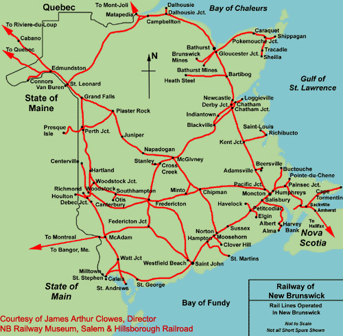
All the distances are in miles. I know this was common out in SK in the not so distant past, but was it the same here? Or was this an American map.
It could be a map from the 70's or early 80's even. Canada switched over to metric in 76, so the maps could be from then. Even in the early 80's there may have been some maps made in miles instead of kms.
Someone familiar with the raillines and companies can probably give a narrower window.
It could be a map from the 70's or early 80's even. Canada switched over to metric in 76, so the maps could be from then. Even in the early 80's there may have been some maps made in miles instead of kms.
Someone familiar with the raillines and companies can probably give a narrower window.
The presence of the Carleton Street Bridge puts it no later than about 1981.
The City Limit is marked on the river cutting off Barkers Point and Nashwaaksis from the city, so before 1973. The CN line that kept going upriver from the York Street Station is still there, and I think it was abandoned when the section above the Mactaquac Dam was flooded, so it could be 60s. The Princess Margaret is there, so definitely after 1959. It also doesn't feature the Nashwaak River Bridge, which was built 1967. Mid-sixties, I'd say.
I don't have a date on this one, but it's cool you can see how College Hill Road used to run directly through the campus and connect to University Avenue.
The map is the 1988-89 city map. I was simply showing that it stated which rail ROW’s were owned by who. They could have been using an old non updated map.
Generally…there’s two crossings each day/each way between North Sydney and Port-aux-Basques with additional crossings for commercial truck traffic and also summertime runs to Argentia.
Here’s Marine Atlantic Highlanders ....ready for boarding 2 hours before our midnight departure from North Sydney….
I had a cabin but there’s also coach and business-class seating available.
Arrival in Port aux Basques was at 7am the next morning.
My trip over to Newfoundland was 2 days after Hurricane Dorian had gone through and the boats were full trying to get caught-up on the backlog of traffic that had accumulated while they weren’t running. Capacity is 450 cars or 90 truck on 2.8 kilometres of lane-length on the ferry.


 Prev
Prev


 Linear Mode
