HomeDiagramsDatabaseMapsForum About
     

Go Back   SkyscraperPage Forum > Photography Forums > Found City Photos

Reply

 
Thread Tools Display Modes
     
     
  #23561  
Old Posted Sep 9, 2014, 3:26 AM
FredH's Avatar
FredH FredH is offline
Registered User
 
Join Date: Aug 2011
Posts: 676


ProphetM: Looks like you may have a winner!


Google Street View
Reply With Quote
     
     
  #23562  
Old Posted Sep 9, 2014, 3:33 AM
FredH's Avatar
FredH FredH is offline
Registered User
 
Join Date: Aug 2011
Posts: 676
City Hall, Hall of Records, Hall of Justice and the old County Courthouse - 12/30/1927


lacityhistory.pastperfect-online.com/40662cgi/mweb.exe?request=record;id=D80328A0-10FA-4625-880C-569482427836;type=102
Reply With Quote
     
     
  #23563  
Old Posted Sep 9, 2014, 3:39 AM
FredH's Avatar
FredH FredH is offline
Registered User
 
Join Date: Aug 2011
Posts: 676
First Street viaduct, looking north toward First Street viaduct from roof of Fourth and Mateo Streets. Railroad yard
and trains in foreground. First Street viaduct was designated a Los Angeles Historic-Cultural Monument in 2008. - 02/13/1929


http://lacityhistory.pastperfect-onl...55605;type=102
Reply With Quote
     
     
  #23564  
Old Posted Sep 9, 2014, 3:48 AM
FredH's Avatar
FredH FredH is offline
Registered User
 
Join Date: Aug 2011
Posts: 676
View eastward along Malibu Road (now Pacific Coast Highway) at Santa Monica Canyon. Taken from south side of
highway at West Channel Road. Showing flooding down Santa Monica Canyon to beach with piles of debris at base
of flood water. Pedestrian sign for tunnel to beach access and Texaco Gas Station in road east of flooding. Despite
heavy rainfall exceeding six inches that day there appears to have been a break in the rain when the photograph
was taken. - 03/02/1938 - March 1938 Flood


http://lacityhistory.pastperfect-onl...81002;type=102
Reply With Quote
     
     
  #23565  
Old Posted Sep 9, 2014, 4:06 AM
knites knites is offline
Registered User
 
Join Date: Aug 2013
Posts: 6
Quote:
Originally Posted by FredH View Post
First Street viaduct, looking north toward First Street viaduct from roof of Fourth and Mateo Streets. Railroad yard
and trains in foreground. First Street viaduct was designated a Los Angeles Historic-Cultural Monument in 2008. - 02/13/1929


http://lacityhistory.pastperfect-onl...55605;type=102
Great photo. The white building in the foreground is now home to SCI-Arc (Southern California Institute of Architecture). It's longer than the Empire State Building is tall! Across the the street is now the new Michael Maltzen housing project - One Santa Fe. Don't know if it shows up on Google Earth yet but it's a monster of a building that is longgggg…. Runs from where the camera is all the way down to the First Street Viaduct.
Reply With Quote
     
     
  #23566  
Old Posted Sep 9, 2014, 4:38 AM
MartinTurnbull's Avatar
MartinTurnbull MartinTurnbull is offline
Registered User
 
Join Date: Oct 2011
Location: Los Angeles
Posts: 223
Estrada's Spanish Kitchen, Wilshire Blvd at Ardmore

I scanned this shot of Wilshire Blvd at the corner of Ardmore from a book about Bullock's Wilshire.

The restaurant on the right is called Estrada's Spanish Kitchen. Has anybody come across any other (ie better) photos of it?


Reply With Quote
     
     
  #23567  
Old Posted Sep 9, 2014, 4:40 AM
FredH's Avatar
FredH FredH is offline
Registered User
 
Join Date: Aug 2011
Posts: 676
Shasta Apartments, Mike’s Grocery Store, Norfolk Apartments, First Street and Figueroa - 12/18/1935


lacityhistory.pastperfect-online.com/40662cgi/mweb.exe?request=record;id=3B0285F8-30C2-4565-BE7F-911994061469;type=102
Reply With Quote
     
     
  #23568  
Old Posted Sep 9, 2014, 10:13 AM
gsjansen's Avatar
gsjansen gsjansen is offline
Registered User
 
Join Date: Apr 2010
Posts: 684
Susan Hayward as Barbara Graham, boards a bus at 3rd and Bunker hill Avenue in the 1958 movie, I Want to Live!


GSJ
Reply With Quote
     
     
  #23569  
Old Posted Sep 9, 2014, 11:40 AM
gsjansen's Avatar
gsjansen gsjansen is offline
Registered User
 
Join Date: Apr 2010
Posts: 684
Even though Susan Hayward hopped on the bus at Bunker Hill and 3rd, moments later in the film, the bus rolls past our old friend, The New Grand, (formerly the old Nugent) hotel, at Grand and 3rd, a full block East of where she boarded it.


GSJ
Reply With Quote
     
     
  #23570  
Old Posted Sep 9, 2014, 1:02 PM
gsjansen's Avatar
gsjansen gsjansen is offline
Registered User
 
Join Date: Apr 2010
Posts: 684
One more screen cap from 1958's "I want to Live!"

Looking west On Hollywood Boulevard from Hollywood and Vine


GSJ
Reply With Quote
     
     
  #23571  
Old Posted Sep 9, 2014, 2:11 PM
HossC's Avatar
HossC HossC is offline
Registered User
 
Join Date: Aug 2013
Posts: 4,245
Waverly Avenue and Hyperion Avenue at a grade separation looking north toward the approach of Glendale-Hyperion Viaduct. (10/11/1927)


Los Angeles City Historical Society

The same view today.


GSV

When I first saw the black and white picture above, I assumed that the structure behind the bridge was an oil well. Then I found the picture below. Lange & Bergstrom was the company that constructed the Glendale-Hyperion Viaduct. From what I've read, the planned completion date of May 1928 was pushed back a couple of times. An article on Big Orange Landmarks says that the viaduct wasn't completely finished until the end of February 1929.

Glendale-Hyperion Viaduct looking north from the end of Waverly Avenue Bridge. Designated a Los Angeles Historic-Cultural Monument in 1976, the bridge was designed by Merrill Butler who was the city’s chief bridge engineer during the 1920s and was responsible for construction of most of the city’s historic bridges still standing. The Glendale-Hyperion Viaduct and bridge is 56 ft-wide, and is 1,340 feet long, was completed in 1928 and features a series of thirteen concrete arches. (10/11/1927)


Los Angeles City Historical Society

Here's an closer view of the tower in the middle of the roadway, which probably explains why there's a barrier in the road on the far right of the first picture above.

Glendale-Hyperion viaduct, looking northeast on Hyperion Avenue from bridge at Waverly Drive. Lange and Bergstrom construction equipment. The Glendale-Hyperion Viaduct and bridge completed in 1928 is 56 ft-wide, 1,340 feet long and features a series of thirteen concrete arches. Designated a Los Angeles Historic-Cultural Monument in 1976, the bridge was designed by Merrill Butler who was the city’s chief bridge engineer during the 1920s and was responsible for construction of most of the city’s historic bridges still standing. (09/14/1928)


Los Angeles City Historical Society

From the Big Orange Landmarks article, here's an up-to-date view from the Waverly Avenue bridge.


Floyd B. Bariscale, on Flickr


Also check out:

http://forum.skyscraperpage.com/show...postcount=9455

http://forum.skyscraperpage.com/show...ostcount=14224
Reply With Quote
     
     
  #23572  
Old Posted Sep 9, 2014, 4:05 PM
Andys Andys is offline
Registered User
 
Join Date: Aug 2013
Posts: 76
HossC,

Thanks for the Hyperion viaduct photos. For three years in the 1960's, I walked to Marshall High School from Atwater (Village) on that viaduct. Kinda crazy walking that narrow one-person sidewalk in the second photo, with traffic zooming by, but I survived!

Andys
Reply With Quote
     
     
  #23573  
Old Posted Sep 9, 2014, 7:54 PM
Martin Pal Martin Pal is offline
Registered User
 
Join Date: Sep 2013
Posts: 2,454
Quote:
Originally Posted by CityBoyDoug View Post

Pan Am archives.com
Is that a book on the table? Sky Gypsy?

I read a book titled NIGHT OVER WATER by Ken Follet that takes place on this plane. Or similar.

Wikipedia info: Night Over Water is a fictionalized account of the final flight of the Pan American Clipper passenger airplane during the first few days of World War II, early September, 1939. Follett is careful to state that, though the flight and all of the characters are fictional the plane, a Boeing 314, was real and was nicknamed the "Pan Am Clipper."

___________

Aquatone!

Online I found out that the book on the table is:


SKY GYPSY
25,OOO MILES BY FLYING CLIPPER SHIPS OVER SOUTH
AMERICA, CENTRAL AMERICA, MEXICO AND THE CARIBBEAN
by Claudia Cranston

w/30 illustrations in aquatone (photographs) and 3 maps

Published by:
J. B. LIPPINCOTT COMPANY
Philadelphia – London
Copyright 1935, 1936

This version spells it GIPSY:

Reply With Quote
     
     
  #23574  
Old Posted Sep 9, 2014, 8:24 PM
Retired_in_Texas Retired_in_Texas is offline
Registered User
 
Join Date: Aug 2013
Posts: 219
Quote:
Originally Posted by gsjansen View Post
One more screen cap from 1958's "I want to Live!"

Looking west On Hollywood Boulevard from Hollywood and Vine


GSJ
Thanks for the great screen shot for those of us who remember Hollywood and Vine when it was actually part of a neighborhood where people did normal things. Amazing how the Walk of Fame, radio and TV shows transitioned it into a tourist trap and ultimately into being virtually skid row for a number of years. Regardless of all the attempts to bring the area back, it will never again be as it was in the years before 1960.
Reply With Quote
     
     
  #23575  
Old Posted Sep 9, 2014, 8:37 PM
gsjansen's Avatar
gsjansen gsjansen is offline
Registered User
 
Join Date: Apr 2010
Posts: 684
Quote:
Originally Posted by HossC View Post
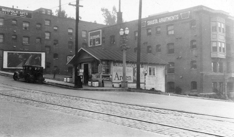
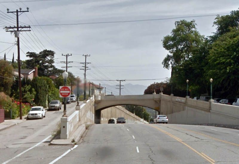
The recent question by shadyguy about the dead-end stub of 4th Street at Hope prompted me to look for pictures. I think most of the pictures below are new to NLA, but I didn't check every one!.............


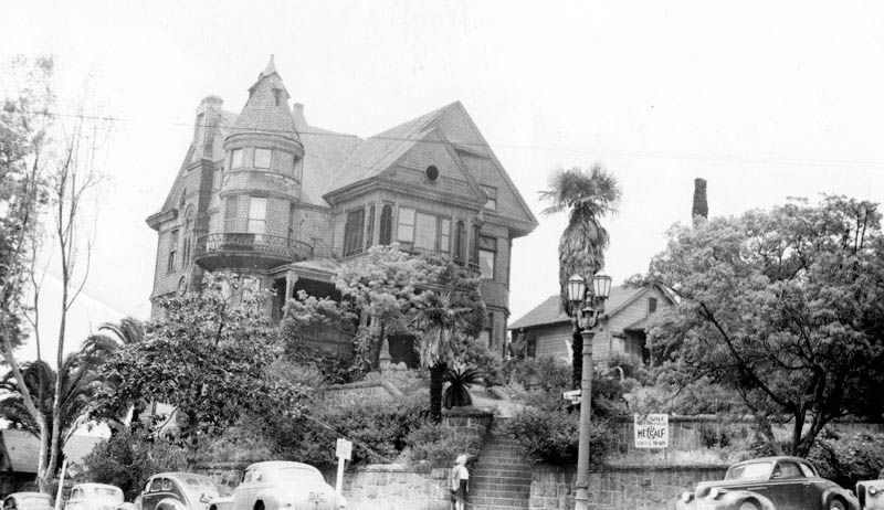
Skipping forward to 1946, Mabel Haufe, one of the home's new owners, stands at the base of the stairs. The "For Sale" sign has yet to be removed.


LAPL
This image of Mabel Haufe has answered one of my long nagging questions with regards to the rear carriage house for the Hildreth!

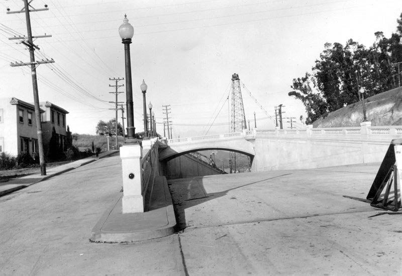
The image below was discussed on this here thread some 4 1/2 years ago, and while it was discussed and assumed to be the carriage house for the hildreth,(particularly as the retaining wall is of the same material as can be seen on the many photos of the hildreth at the corner of hope and and 4th), I could never get my mind around how it sat on the site with relation to the main house. Even though it made sense that it was part of the Hildreth property, i just couldn't come to grasp with how.............


LAPL

The image posted by HossC actually shows the carriage house at the bottom left hand corner of the photograph. Being that to date, no clear images taken from flower, or even Figueroa looking up at the back of the Hildreth has surfaced, (hence the ongoing discussion of the 4th street Stub.....), I just never realized until now, that the carriage house is situated on a North South axis, perpendicular to the Hildreth! The retaining wall wrapped around the property!

This image is actually of the end, (or start if you prefer), of the 4th street Stub!

This has now closed the book on something that has bothered me for some time!
Reply With Quote
     
     
  #23576  
Old Posted Sep 9, 2014, 9:25 PM
CityBoyDoug CityBoyDoug is offline
BANNED
 
Join Date: Apr 2013
Posts: 2,868
Quote:
Originally Posted by Retired_in_Texas View Post
Thanks for the great screen shot for those of us who remember Hollywood and Vine when it was actually part of a neighborhood where people did normal things. Amazing how the Walk of Fame, radio and TV shows transitioned it into a tourist trap and ultimately into being virtually skid row for a number of years. Regardless of all the attempts to bring the area back, it will never again be as it was in the years before 1960.
Yes, Hollywood Blvd. has turned into an endless Dollar Store.
Reply With Quote
     
     
  #23577  
Old Posted Sep 9, 2014, 9:29 PM
CityBoyDoug CityBoyDoug is offline
BANNED
 
Join Date: Apr 2013
Posts: 2,868
Quote:
Originally Posted by Andys View Post
HossC,

Thanks for the Hyperion viaduct photos. For three years in the 1960's, I walked to Marshall High School from Atwater (Village) on that viaduct. Kinda crazy walking that narrow one-person sidewalk in the second photo, with traffic zooming by, but I survived!

Andys
I suspect that narrow sidewalk is a violation of City Code.
Reply With Quote
     
     
  #23578  
Old Posted Sep 9, 2014, 9:31 PM
CityBoyDoug CityBoyDoug is offline
BANNED
 
Join Date: Apr 2013
Posts: 2,868
Wings Over The World........

Quote:
Originally Posted by Martin Pal;

This version spells it GIPSY:

[img
http://ecx.images-amazon.com/images/I/419UL19y4zL._SY344_BO1,204,203,200_.jpg[/img]
Hey thanks Martin for the cool info. Odd change of name for the book. I suspect politics is the reason.
Reply With Quote
     
     
  #23579  
Old Posted Sep 9, 2014, 10:08 PM
HossC's Avatar
HossC HossC is offline
Registered User
 
Join Date: Aug 2013
Posts: 4,245
Quote:
Originally Posted by Martin Pal View Post

Is that a book on the table? Sky Gypsy?

...

This version spells it GIPSY
Quote:
Originally Posted by CityBoyDoug View Post

Odd change of name for the book. I suspect politics is the reason.
"Gipsy" used to be the preferred British English spelling of "Gypsy", so I guess the two books found online by Martin Pal were originally sold in different markets.
Reply With Quote
     
     
  #23580  
Old Posted Sep 9, 2014, 11:37 PM
ethereal_reality's Avatar
ethereal_reality ethereal_reality is offline
Registered User
 
Join Date: Feb 2008
Location: Lafayette/West Lafayette IN, Purdue U.
Posts: 16,356
This photograph of three models admiring "the Stacks' is fairly familiar and has probably appeared on NLA

1955

rtc/o_file


but I recently came across this photograph showing the same three models posed near Cahuenga Pass.

1954

RedTide/file

Obviously one of the dates is incorrect, as the models are wearing the same clothing in both photographs.

__

Last edited by ethereal_reality; Sep 10, 2014 at 12:12 AM.
Reply With Quote
     
     
This discussion thread continues

Use the page links to the lower-right to go to the next page for additional posts

Reply

Go Back   SkyscraperPage Forum > Photography Forums > Found City Photos
Forum Jump


Forum Jump


All times are GMT. The time now is 2:16 PM.

     
SkyscraperPage.com - Archive - Privacy Statement - Top

Powered by vBulletin® Version 3.8.7
Copyright ©2000 - 2024, vBulletin Solutions, Inc.