Quote:
Originally Posted by ethereal_reality

|
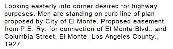
I think the new boulevard described may be Ramona Blvd., which runs from El Monte towards Baldwin Park, Covina, San Dimas and La Verne. The caption indicates that the easement is a plan by the City of El Monte, so presumably it's within the 1927 city limits of El Monte, which were quite small. I have a 1932 USGS map overlaid on Google Earth and it's basically centered around what is now Valley Mall and Tyler Ave. On this map, Valley Mall and Valley Blvd. are called Pomona Blvd., and head southeast to Pomona, while most of today's Ramona Blvd. towards the northeast is a Pacific Electric line. Several blocks do exist however, from Santa Anita Ave. to Valley Blvd., east of which the modern road jogs a bit northward to join the PE line. The old map also seems to show a church at the south corner of Ramona Blvd. and Valley Blvd., and that's the area I'm guessing for this photo. If that's the case, the site of the church is now the north corner of a parking garage for the El Monte Courthouse of the LA Superior Court. The empty lot where the men and photographer are standing would be the east corner of Ramona Blvd. & Valley Blvd., currently holding a Bank of America.
So my supposition is that today's Ramona Blvd. west of Valley was Columbia St., and today's Ramona Blvd. east of Valley was the proposed El Monte Blvd. Where the direction changes slightly at Valley, a jog cutting off the corner is required to join the two parts.


 Prev
Prev


 Linear Mode
