HomeDiagramsDatabaseMapsForum About
     

Go Back   SkyscraperPage Forum > Photography Forums > Found City Photos

Reply

 
Thread Tools Display Modes
     
     
  #13661  
Old Posted Apr 1, 2013, 4:11 PM
Godzilla Godzilla is offline
Registered User
 
Join Date: Sep 2012
Posts: 726
Quote:
Originally Posted by MichaelRyerson View Post
Not to worry, we all make 'em but I still feel as though the source may be wrong. see below...


Freeway Link Open to Civic Center, 1951 (3)

20 December 1951. View showing first cars approaching the Civic Center on new half-mile link.

USC digital archive/Los Angeles Examiner Collection, 1920-1961

To be fair, the source prefaces '53 with "ca." - and it is the correct decade. http://catalog.library.ca.gov/F/XF65..._library=CALIF


Quote:
The entire Santa Ana Freeway began construction in 1947 and completed in 1956. Originally it was signed as US 101 before the segment of 101 between the East Los Angeles Interchange and the [US-Mexico border] in [San Yisidro] was decommissioned in favor of [Interstate 5] It was approved as a chargeable interstate in 1961. The Santa Ana Freeway and also portions of San Diego Freeway (before the freeway was built) south of El Toro Y went up changing the U.S. 101 signs to Interstate 5 in 1964, including full length of Golden State Freeway which was originally signed as US 99.http://en.wikipedia.org/wiki/Santa_Ana_Freeway
Reply With Quote
     
     
  #13662  
Old Posted Apr 1, 2013, 6:36 PM
MichaelRyerson's Avatar
MichaelRyerson MichaelRyerson is offline
Registered User
 
Join Date: Feb 2011
Location: Houston, Texas
Posts: 1,155
Yeah well, circa works. I happen to have a clear memory of this freeway opening as it resulted in a certain amount of Sunday driving to test it out in my family. Hard to believe but that center median was actually grass in those days (hard to see it in this pic) and completely without any other restraining feature like chain link or cables or concrete abutments. Once, while sitting in an eastbound traffic jam, on our way to my grandparents house in Claremont, we inched past a car that had simply been pulled up onto this very median just ahead, slightly beyond the Hill Street overpass, and the family had gotten out of their car and spread a picnic lunch out on the grass and were sitting there eating as we went by at about three miles an hour. It was truly a different time.
Reply With Quote
     
     
  #13663  
Old Posted Apr 1, 2013, 9:06 PM
tovangar2 tovangar2 is offline
Registered User
 
Join Date: Nov 2012
Location: West Los Angeles
Posts: 2,625
Quote:
Originally Posted by Godzilla View Post
September 7, 1938 - Captioned "Jitterbugs disrupt City Council." If they danced to music, assume there was a band on hand. FDR's portrait looks to be at least four or five feet tall.

lapl
Quote:
Originally Posted by kznyc2k View Post
Very cool to see the portrait of Roosevelt on the wall. It immediately made me think of my all-time favorite movie, Chinatown, whose set dressers either did a phenomenal job reproducing the portrait or actually dug the original up from god knows where. Either way it makes me love the movie even more!

"1946 - FDR's picture removed from City Hall"

reddawgcollectables/eBay
Reply With Quote
     
     
  #13664  
Old Posted Apr 1, 2013, 9:16 PM
LA Jeff LA Jeff is offline
Registered User
 
Join Date: Mar 2013
Location: Los Angeles
Posts: 9
I wonder how many Hollywood residents know there is a fine-looking dam up in nearby Weid Canyon hovering over them.

http://waterandpower.org/Historical_...od_ca_1928.jpg

The dam was built between 1924-1926 and was completely visible to all of Hollywood until the 1930s, when it was reinforced with tons of earth following the 1928 collapse of St. Francis Dam in the Santa Clarita area 30 or so miles to the north. The water level of Lake Hollywood was also lowered in response to the St. Francis Dam bursting.


http://waterandpower.org/Historical_...od_ca_1928.jpg


http://waterandpower.org/Historical_...ping_Plant.jpg

Not too many Californians know about the St. Francis Dam disaster even though over 500 people died. The dam before it burst....

http://4.bp.blogspot.com/-lgCljp62Cl...rancis_Dam.jpg

....and after

http://www.fillmoregazette.com/files...rancis_Dam.jpg

Here’s an amazing shot of the St. Francis reservoir a day or two later after all 12 billion gallons had drained out of it in only around one hour.

http://www.scvhistory.com/gif/ws2802.jpg

William Mulholland (Mulholland Drive) was the designer of both dams. I knew a man who was at St. Francis Dam a few days before it collapsed on March 12, 1928. He recalled seeing a good deal of muddy water leaking from around the edges of the dam and wisely choosing not to stay around much longer. Mulholland and his assistant, Van Norman (who has a reservoir named after him in the San Fernando Valley) inspected the dam on the day it burst and proclaimed the leakage to be normal and the dam to be structurally sound.

Mulholland at the St. Francis Dam site the following morning.

http://www.usc.edu/libraries/archive...land_dam3.jpeg
Reply With Quote
     
     
  #13665  
Old Posted Apr 1, 2013, 10:59 PM
tovangar2 tovangar2 is offline
Registered User
 
Join Date: Nov 2012
Location: West Los Angeles
Posts: 2,625

Last edited by tovangar2; Apr 2, 2013 at 3:12 AM.
Reply With Quote
     
     
  #13666  
Old Posted Apr 1, 2013, 11:30 PM
ethereal_reality's Avatar
ethereal_reality ethereal_reality is offline
Registered User
 
Join Date: Feb 2008
Location: Lafayette/West Lafayette IN, Purdue U.
Posts: 16,352
1924 Map originally posted by GaylordWilshire

http://forum.skyscraperpage.com/show...postcount=7491


http://photos.lapl.org/carlweb/jsp/F...Number=5070332


In 1924 Victor Girard (1880-1954) opened a real estate office on what is now Topanga Canyon and Ventura Boulevard and built a mosque-like gate to his 2886-acre subdivision named Girard. He graded the streets, set aside land for parks and schools, and planted thousands of trees.
In 1941 to community's name was changed to Woodland Hills.


http://photos.lapl.org/carlweb/jsp/F...Number=5070332


http://photos.lapl.org/carlweb/jsp/F...Number=5070332


below: A Girard street scene circa 1937 showing a three-tiered fountain. In the distance is a large blade sign that says Drugs, and a smaller 'cafe' sign attached to a building with a conical roof.


http://photos.lapl.org/carlweb/jsp/F...Number=5070334

I wonder if the drug store building and fountain has survived. (no address is given)

__

Last edited by ethereal_reality; Apr 1, 2013 at 11:54 PM.
Reply With Quote
     
     
  #13667  
Old Posted Apr 1, 2013, 11:37 PM
ethereal_reality's Avatar
ethereal_reality ethereal_reality is offline
Registered User
 
Join Date: Feb 2008
Location: Lafayette/West Lafayette IN, Purdue U.
Posts: 16,352
Here is one more of the real estate syndicate building in Girard. It's much larger than I initially thought.


http://photos.lapl.org/carlweb/jsp/F...olNumber=78290
__
Reply With Quote
     
     
  #13668  
Old Posted Apr 1, 2013, 11:55 PM
MichaelRyerson's Avatar
MichaelRyerson MichaelRyerson is offline
Registered User
 
Join Date: Feb 2011
Location: Houston, Texas
Posts: 1,155
Quote:
Originally Posted by ethereal_reality View Post
1924 Map originally posted by GaylordWilshire

http://forum.skyscraperpage.com/show...postcount=7491


http://photos.lapl.org/carlweb/jsp/F...Number=5070332


In 1924 Victor Girard (1880-1954) opened a real estate office on what is now Topanga Canyon and Ventura Boulevard and built a mosque-like gate to his 2886-acre subdivision named Girard. He graded the streets, set aside land for parks and schools, and planted thousands of trees.
In 1941 to community's name was changed to Woodland Hills.


http://photos.lapl.org/carlweb/jsp/F...Number=5070332


http://photos.lapl.org/carlweb/jsp/F...Number=5070332


below: A Girard street scene circa 1937 showing a three-tiered fountain. No address is given, but in the distance is a large blade sign that says Drugs, and a smaller 'cafe' sign attached to a building with a conical roof.


http://photos.lapl.org/carlweb/jsp/F...Number=5070334

I wonder if the drug store building and fountain has survived.

__

No, neither survived. My wife and I are from this area, we both went to the same high school and we bought our first house about ten blocks south of here on San Miguel Street. Girard's promotional 'improvements' were built along the south side of Ventura Boulevard for a block or so on each side of Topanga Canyon Boulevard. I think the fountain was just west of the intersection on the south side. I have all of these pics in my photo-stream. The oldest building still in use along this stretch of Ventura is Franklin's Hardware and it came along after these structures had long since disappeared.
Reply With Quote
     
     
  #13669  
Old Posted Apr 2, 2013, 12:09 AM
ethereal_reality's Avatar
ethereal_reality ethereal_reality is offline
Registered User
 
Join Date: Feb 2008
Location: Lafayette/West Lafayette IN, Purdue U.
Posts: 16,352
Thanks for the information MichaelRyerson. -much appreciated
__
Reply With Quote
     
     
  #13670  
Old Posted Apr 2, 2013, 12:17 AM
SoCal1954's Avatar
SoCal1954 SoCal1954 is offline
Registered User
 
Join Date: Mar 2013
Location: SoCal
Posts: 46
Quote:
Originally Posted by ethereal_reality View Post
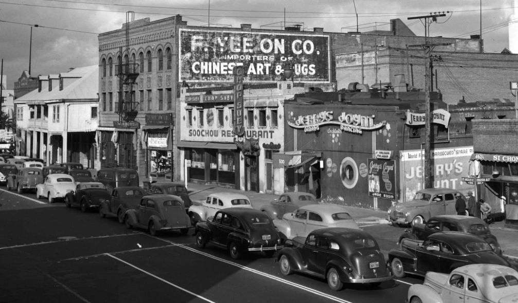
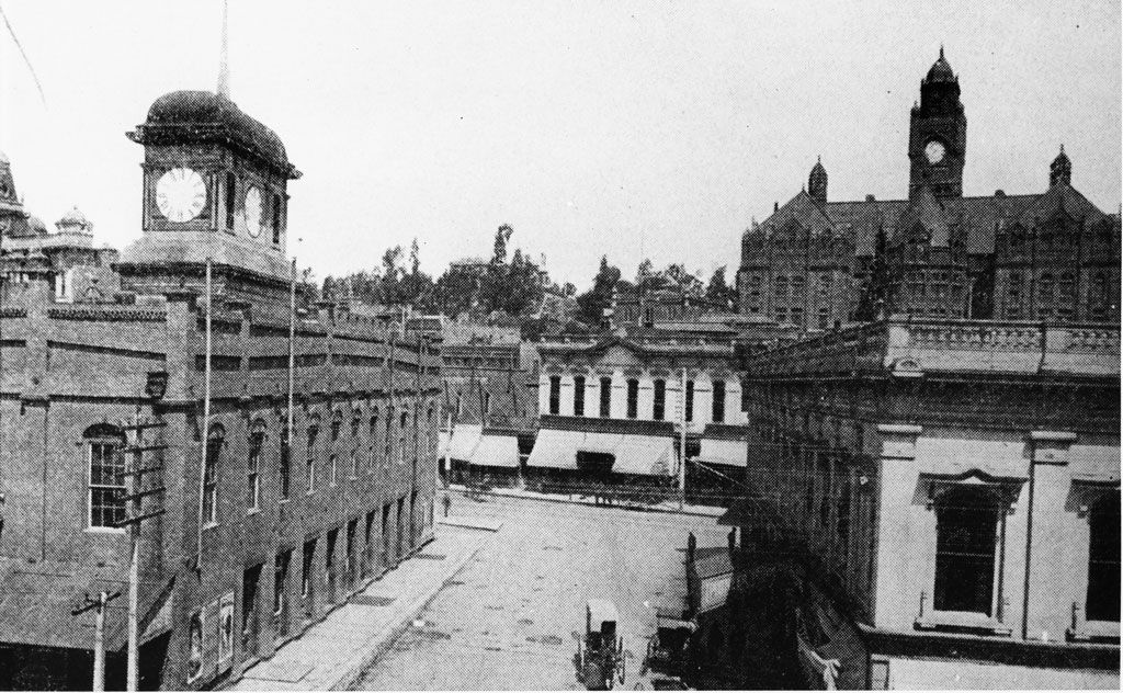
Here's a shot of the whole street, 400 block of Los Angeles St.


calisphere
Hi, my first post in your great Site/Forum. Each of you (members) do such a great job here!!


This is a really great photo; this area of Old Chinatown has special interest to me, as does much of the L.A. area. And yes, it is amazing how this specific area has been transformed, starting with the building of Union Station and then the Santa Ana freeway access ramps...so much history here!

A little more background on this photo: Jerry's Joint was a late night restaurant and dance hall, owned by G.H. Surpenant, who passed away in 1956. The Soochow Restaurant (current Pinyin transliteration is Suzhou) was owned by Architect Gilbert Leong. Leong, and his brother in law, Eddy See, who owned the nearby Dragon's Den (shown in other photos in this forum) tried to save the businesses, with a detailed plan for a Multicultural Retail Center; however, the L.A. City Council decided to go ahead with the plans for the Hollywood Freeway access ramps. (Multiple research souces including the book Chinatown in Los Angeles by Jenny Cho)

The American Women's Voluntary Services Organization (Chinese American Unit), relocated a servicemen's canteen in September 1944, to the Leong family's Soochow Restaurant. Serving 1,500 military personnel each month, 105 (Primarily Chinese American) women kept the canteen open, making it known as the "best place next to home."

From what I have researched, this street and these buildings were fully demolished around late 1950, with this adjacent downtown section of the Hollywood Fwy., opening in late 1951. I imagine that the public outcry for better and faster access to the (at the time) very busy Union Station, and its train service, was more important to the L.A. City Council (in that era) than any plan to rejuvenate the old China Town; when the new China Town had already been established since 1938/39.

Last , I have an old post card from Jerry's Joint, showing the large jade carving which was on display there for years...I wonder where it is today?

Reply With Quote
     
     
  #13671  
Old Posted Apr 2, 2013, 12:26 AM
ethereal_reality's Avatar
ethereal_reality ethereal_reality is offline
Registered User
 
Join Date: Feb 2008
Location: Lafayette/West Lafayette IN, Purdue U.
Posts: 16,352
Very interesting post SoCal54. Welcome to noirish Los Angeles!
__


Attempted suicide on Old Topanga Road April 13, 1952.


http://digitallibrary.usc.edu/

I don't understand how this was an attempted suicide....unless he removed those boards before hand.
Even so, he should have picked a deeper ditch.
__

Last edited by ethereal_reality; Apr 2, 2013 at 12:41 AM.
Reply With Quote
     
     
  #13672  
Old Posted Apr 2, 2013, 12:42 AM
tovangar2 tovangar2 is offline
Registered User
 
Join Date: Nov 2012
Location: West Los Angeles
Posts: 2,625
Quote:
Originally Posted by Los Angeles Past View Post
On the north side of Market was the south portion of the Temple Block; on the south side was the original market building erected in 1859 by John Temple, which later became Los Angeles County's first Court House. Here is a view of Market Street looking west from the cupola of the United States Hotel in 1889, soon after the construction of the new Court House on Pound Cake Hill (background). The old market and Court House can be seen at left.

U.S.C. Digital Library
The Clocktower Courthouse was between Court and Market Streets, nicely memorializing both uses of the building.

In Paul Bryan Gray's bio of Francisco P. Ramiez, "A Clamor for Equality", 2012, it's noted that John Temple may have built the LA Market Building (1859) from his memory of Faneuil Hall (1742), in his native Massachusetts.

Has anyone heard that before?

Faneuil Hall as built:

http://commons.wikimedia.org/wiki/Fi...A_-_535907.jpg

It looks rather different now as it was doubled in height and width in 1805 and a third floor added, plus the tower was moved to the end. It was entirely rebuilt in 1898-99.

Faneuil Hall, in turn, was patterned after market buildings in English country towns.
Reply With Quote
     
     
  #13673  
Old Posted Apr 2, 2013, 12:47 AM
ethereal_reality's Avatar
ethereal_reality ethereal_reality is offline
Registered User
 
Join Date: Feb 2008
Location: Lafayette/West Lafayette IN, Purdue U.
Posts: 16,352
nice view of vintage cars.

Kodachrome slide/Los Angeles

ebay

Ok folks, which Ohrbachs is this?
__
Reply With Quote
     
     
  #13674  
Old Posted Apr 2, 2013, 1:13 AM
MichaelRyerson's Avatar
MichaelRyerson MichaelRyerson is offline
Registered User
 
Join Date: Feb 2011
Location: Houston, Texas
Posts: 1,155
At the other end of Topanga Canyon...


Topanga Beach Auto Court, 1939

Topanga Beach Auto Court at the mouth of Topanga Canyon and Pacific Coast Highway, 1939

doctorjazz.co.uk
Reply With Quote
     
     
  #13675  
Old Posted Apr 2, 2013, 1:18 AM
tovangar2 tovangar2 is offline
Registered User
 
Join Date: Nov 2012
Location: West Los Angeles
Posts: 2,625
Quote:
Originally Posted by SoCal1954 View Post
Hi, my first post in your great Site/Forum. Each of you (members) do such a great job here!!

This is a really great photo; this area of Old Chinatown has special interest to me, as does much of the L.A. area.
Quote:
Originally Posted by ethereal_reality View Post

calisphere
What happened to this area still makes me boil. There was no reason to tear it down except for Sterling's hatred of the last vestiges of old Chinatown. I'll never get over the loss of Lugo House.

The demolition was pointless. There's no there there:

google maps

Welcome :-)

Last edited by tovangar2; Jun 22, 2015 at 10:30 PM. Reason: fix link
Reply With Quote
     
     
  #13676  
Old Posted Apr 2, 2013, 1:45 AM
ethereal_reality's Avatar
ethereal_reality ethereal_reality is offline
Registered User
 
Join Date: Feb 2008
Location: Lafayette/West Lafayette IN, Purdue U.
Posts: 16,352
Truly a heart-felt loss.
__
Reply With Quote
     
     
  #13677  
Old Posted Apr 2, 2013, 1:51 AM
tovangar2 tovangar2 is offline
Registered User
 
Join Date: Nov 2012
Location: West Los Angeles
Posts: 2,625
Quote:
Originally Posted by ethereal_reality View Post
Ok folks, which Ohrbachs is this?
__
Los Cerritos. Last I heard it was a Mervyn's. A mall's been built around it.


http://www.flickr.com/photos/12956306@N00/3691570018/

P.S.

Scratch that.

It's been refaced again and is now a Forever 21

flickr

Last edited by tovangar2; Jun 22, 2015 at 10:44 PM. Reason: fix links
Reply With Quote
     
     
  #13678  
Old Posted Apr 2, 2013, 2:07 AM
Chuckaluck Chuckaluck is offline
Registered User
 
Join Date: Apr 2012
Posts: 649
Quote:
Originally Posted by Godzilla View Post

1926 - A familiar intersection?
Lapl


1925
Lapl


1937
Lapl

1942
Lapl

Undated Artist's rendering
Lapl

Lapl

**

The Uptown evidently featured very prominently in the life of Sci-Fi author Ray Bradbury.

Quote:
[In 1934, when Bradbury was 14, the family arrived [in LA] with only 40 dollars, which paid for rent and food until his father finally found a job making wire at a cable company for $14 a week. This meant they could stay and Bradbury, who was in love with Hollywood, was ecstatic.

The family lived about four blocks from the Uptown Theater on Western Avenue in Los Angeles, the flagship theater for MGM and Fox. There, Bradbury learned how to sneak in and watched previews almost every week. He roller-skated there as well as all over town, as he put it "hell-bent on getting autographs from glamorous stars. It was glorious." Among stars the young Bradbury was thrilled to encounter were Norma Shearer, Laurel and Hardy, and Ronald Colman. Sometimes he would spend all day in front of Paramount Pictures or Columbia Pictures and then skate to the Brown Derby to watch the stars who came and went for meals. He recounted seeing Cary Grant, Marlene Dietrich and Mae West, who he would learn made a regular appearance every Friday night, bodyguard in tow. http://en.wikipedia.org/wiki/Ray_Bradbury
In '36, Ray's father, Leonard, was listed as residing at 1619 St. Andrews Place. (House is still there.) http://cbk0.google.com/cbk?output=th...=1&w=300&h=118

More on Ray's LA connection here > http://articles.latimes.com/2012/jun...ritic-20120607

1999 - Ray does Cliftons
lapl

Young Ray and George Burns, date unknown
http://www.radiospirits.info/wp-cont.../bradbury1.jpg


** Original post contains enlargements from site USC. They view fine on my monitor but since others have problems viewing them, they are omitted here. Not sure how to reproduce them in universally viewable format. They are good though. Try adjusting screen size.

Reply With Quote
     
     
  #13679  
Old Posted Apr 2, 2013, 2:09 AM
LA Jeff LA Jeff is offline
Registered User
 
Join Date: Mar 2013
Location: Los Angeles
Posts: 9
Mulholland was feted, the victims forgotten.
http://forum.skyscraperpage.com/show...ostcount=13232[/QUOTE]

How true, tovangar2.

Apparently the existence of St. Francis Dam was not well known, as Mulholland et al did not want the saboteurs from Owens Valley blowing up the dam either. Therefore, the dire warning that a dam had burst was not taken seriously by some downstream residents and migrant workers in the Santa Clara River valley.

The St. Francis Dam was intended to hold a one-year supply of water for the City of LA in case the supply from the Owens aqueduct became disrupted. The dam was originally designed to be 185 feet tall. However, LA’s population really took off after the dam’s original design was completed. Mulholland then decided to add an extra 20 feet to the dam’s height to increase the capacity of the reservoir by around one-third. Mulholland did not increase the thickness at the base of the dam, however, which is reportedly one of the reasons why the dam failed. Other cited reasons included unstable soil and a fault line in the area as well as the type of concrete Mulholland used for the dam’s construction.

A few more pics of Mulholland Dam/Lake Hollywood
With the “Hollywoodland” sign in the background:

http://i121.photobucket.com/albums/o...ent3_p0118.jpg

I would have been a little nervous living below the dam here

http://i121.photobucket.com/albums/o...ent3_p0124.jpg

http://i121.photobucket.com/albums/o...ent4_p0126.jpg

http://i121.photobucket.com/albums/o...ent3_p0129.jpg

Before and after the dam’s fortification

http://i121.photobucket.com/albums/o...ps1193c646.jpg
Reply With Quote
     
     
  #13680  
Old Posted Apr 2, 2013, 2:34 AM
SoCal1954's Avatar
SoCal1954 SoCal1954 is offline
Registered User
 
Join Date: Mar 2013
Location: SoCal
Posts: 46
Quote:
Originally Posted by ethereal_reality View Post
Very interesting post SoCal54. Welcome to noirish Los Angeles!
__


Attempted suicide on Old Topanga Road April 13, 1952.


http://digitallibrary.usc.edu/

I don't understand how this was an attempted suicide....unless he removed those boards before hand.
Even so, he should have picked a deeper ditch.
__

Thank you!! I have lurked, off and on, for some time now; and as I said, I am very impressed with the content, and the effort folks put forth in this venue!

Great photo! My guess is, that this fool in his late model Old's convertible, just had too much to drink, and couldn't even pull off his attempt suicide. Think what that car would be worth today!?

Addition: Most likely a '50 or '51 Ford with the star on the door (L.A. County Sheriff's Office) with two LASO Dep's in the photo; and also, most likely, a 1952 Ford CHP car, you can just see the leading edge of the white door, officer not visible. The south/west end of Topanga Cyn. Rd. has a lot of unincorporated County area serviced by LASD and CHP, and the north/east end, was mostly in L.A. City, the LAPD's jurisdiction.


1952 CHP patrol car: My personal file.

Last edited by SoCal1954; Apr 2, 2013 at 8:48 PM. Reason: Additional comment
Reply With Quote
     
     
This discussion thread continues

Use the page links to the lower-right to go to the next page for additional posts

Reply

Go Back   SkyscraperPage Forum > Photography Forums > Found City Photos
Forum Jump


Forum Jump


All times are GMT. The time now is 7:58 PM.

     
SkyscraperPage.com - Archive - Privacy Statement - Top

Powered by vBulletin® Version 3.8.7
Copyright ©2000 - 2024, vBulletin Solutions, Inc.