HomeDiagramsDatabaseMapsForum About
     

Go Back   SkyscraperPage Forum > Discussion Forums > Transportation


Reply

 
Thread Tools Display Modes
     
     
  #21  
Old Posted Apr 8, 2012, 12:44 AM
seaskyfan seaskyfan is offline
Registered User
 
Join Date: Feb 2006
Location: Seattle
Posts: 3,751
Thanks for posting the info about Melbourne's system Tayser. I noticed on the map that some of the stations seem to be considered both Zone 1 and Zone 2. How does that work - is it a time of day thing?
Reply With Quote
     
     
  #22  
Old Posted Apr 8, 2012, 12:51 AM
tayser's Avatar
tayser tayser is offline
Vires acquirit eundo
 
Join Date: Mar 2002
Location: Melbourne
Posts: 3,231
nah it's just fare zones.

2 Hour Zone 1: $3.28 Zone 2: $2.26 Zone 1 + 2: $5.54
Daily Zone 1: $6.56 Zone 2: 4.52 Zone 1 + 2: $11.08

just means if you use a myki (think oyster in London, Octopus in HK) and youre travelling is only in zone 1 on tram / train / bus and is completed within a 2hour window, you'll only pay $3.28 (can transfer and do as many journeys within 2 hours) if it takes longer than two hours and you only travel in Zone 1 it'll cost you $6.56 - basically you can go anywhere/everywhere in Zone 1 on tram/train/bus the whole day and max you'll pay is $6.56

same concept if you're travel is all in Zone 2. And if you cross Zones you pay either $5.54 for 2 hours or $11.08 for daily.

with myki, on saturdays and sundays, the max you pay for Zone 1, Zone 2 or Zone 1 + 2 the whole day is $3.30 - tranfer between any tram / train / bus as much as you want.

there are other more complex tickets (basically a weekly or monthly which end up making it cheaper than the daily "myki money" rates)

myki money (credit balance on your card that is debited every time you touch on / touch off): http://ptv.vic.gov.au/fares-tickets/myki/myki-money/#1
myki pass (pre-purchased tickets / pass at the lower rates): http://ptv.vic.gov.au/fares-tickets/myki/myki-pass/#1
Reply With Quote
     
     
  #23  
Old Posted Apr 8, 2012, 1:02 AM
seaskyfan seaskyfan is offline
Registered User
 
Join Date: Feb 2006
Location: Seattle
Posts: 3,751
Got it. So the stations that are both yellow and blue on the map can be considered one zone travel for folks from either zone 1 or zone 2?

Also - Batman Station (Upfield Line). Best station name ever.
Reply With Quote
     
     
  #24  
Old Posted Apr 8, 2012, 1:10 AM
tayser's Avatar
tayser tayser is offline
Vires acquirit eundo
 
Join Date: Mar 2002
Location: Melbourne
Posts: 3,231
John Batman founded Gotham... er I mean Melbourne

http://en.wikipedia.org/wiki/John_Batman

The stations which have two zones work like this:

Huntingdale, Oakleigh and Hughesdale (Pakenham/Cranbourne lines) - if you touch your myki on at Huntingdale and travel in the down direction (away from the city) you'll be on a Zone 2 fare - if you travel in the up direction (toward the city) you'll be on a Zone 1 fare. Likewise at Hughesdale and Oakleigh - down direction Zone 2, up direction Zone 1 etc.

btw fflint - for an example of stopping patterns, have a look at the new timetables to come into effect on April 22nd: http://newtimetable.metrotrains.com.au/

Specifically: http://newtimetable.metrotrains.com....pr2012_web.pdf re: what I was talking about earlier in my example.

note in the above, that timetable is for the Pakenham and Cranbourne lines which converge at Dandenong.... it also shows trains which "appear" to start at Caulfield - but these are Frankston line trains which join the main line at Caulfield. Pakenham - Dandenong = 2 tracks, Cranbourne - Dandenong 1 track (with one new loop at the new Lynbrook station), Dandenong - Caulfield = 2 tracks, Caulfield - South Yarra = 4 tracks (Frankston Line), South Yarra - Richmond = 6 tracks (Sandringham Line), Richmond = Flinders Street = 10 tracks (Belgrave/Lilydale/Alamein/Glen Waverley lines).

Pakenham/Cranbourne/Frankston are the "Caulfield Group"
Glen Waverley/Belgrave/Lilydale/Alamein are the "Burnley Group"
Epping (now South Morang)/Hurstbridge are the "Clifton Hill Group"
Upfield/Craigieburn/Sydenham/Werribee/Williamstown are the "Northern Group"

each group has a single track "loop" tunnel around the CBD - some trains go direct to the terminus at Flinders Street, most will loop around the city either clockwise or anti-clockwise depending on the time of the day
Reply With Quote
     
     
  #25  
Old Posted Apr 8, 2012, 1:18 AM
seaskyfan seaskyfan is offline
Registered User
 
Join Date: Feb 2006
Location: Seattle
Posts: 3,751
Thanks for the info Tayser.
Reply With Quote
     
     
  #26  
Old Posted Apr 17, 2012, 10:00 AM
tayser's Avatar
tayser tayser is offline
Vires acquirit eundo
 
Join Date: Mar 2002
Location: Melbourne
Posts: 3,231
Quote:
http://www.theage.com.au/victoria/gl...416-1x3v8.html

Glimpse of train service in 2021 emerges
Adam Carey
April 17, 2012


The 'train service plan'.
A GLIMPSE of what Melbourne's train timetable could look like 10 years from now has emerged from a government study into building a new rail line to Monash University and Rowville.

It reveals a plan to run trains as often as every four to five minutes in rush hour on some metro lines, and once every 10 minutes outside the peak.

The three-page ''train service plan'' for the year 2021 was published as an appendix to the lengthy government-commissioned Rowville Rail Study. It also gives an early peek at projected increases to V/Line trains to Geelong, Ballarat and Bendigo once the $5 billion regional rail link opens in 2016.

see link for rest of the article.

And to make it easier to understand, I overlaid the 10 year aspiration frequency on the newest/latest version of the metro map (includes new South Morang extension and two new stations on Pakenham/Cranbourne line) - note in 6 months the map will change again with the "colouring in" of the Sunbury line - it's in the final stages of being electrified and the Sydenham line will effectively end in Sunbury.


Number on Left = Peak frequency per hour, number on right = off-peak frequency per hour (mapped according to the image from the article above).
Reply With Quote
     
     
  #27  
Old Posted Apr 18, 2012, 2:20 PM
tayser's Avatar
tayser tayser is offline
Vires acquirit eundo
 
Join Date: Mar 2002
Location: Melbourne
Posts: 3,231
Reply With Quote
     
     
  #28  
Old Posted Apr 18, 2012, 7:58 PM
miketoronto miketoronto is offline
Registered User
 
Join Date: Jul 2001
Location: Toronto, Ontario, Canada
Posts: 9,978
I would like to know what the rail service was like decades ago.

From some reading I have done, it seems Melbourne is just adding service back that used to operate 20 or 30 years ago.
__________________
Miketoronto
Reply With Quote
     
     
  #29  
Old Posted Apr 19, 2012, 12:40 AM
OhioGuy OhioGuy is offline
Registered User
 
Join Date: Jul 2004
Location: DC
Posts: 7,653
I see on the map a 31 indicating 31 trains per hour during the peak rush period? So basically you'll wait less than 2 minutes? That's impressive!

On top of that, the same area has 12 trains per hour during the off-peak period, meaning headways of just 5 minutes. Again, that's impressive!

What about weekends? Just as frequent as off-peak period or less frequent?
Reply With Quote
     
     
  #30  
Old Posted Apr 19, 2012, 1:02 AM
tayser's Avatar
tayser tayser is offline
Vires acquirit eundo
 
Join Date: Mar 2002
Location: Melbourne
Posts: 3,231
Caulfield (31 - 12) can handle that frequency as it's where the Frankston Line joins the Dandenong line and from Caulfield to South Yarra is quadruple track. South Yarra would see 39 - 18 because that's where Sandringham line joins and it's sextuple track from there to Richmond.

Likewise Burnley is where the Ringwood corridor trains join the Glen Waverley line and it's quadruple track to Richmond and from Richmond there's decuple track to Flinders Street - 68 peak hour services 30 off-peak.

From April 22nd, trains between City and Frankston, City and Dandenong and City and Ringwood will run every 10 minutes on Saturdays and Sundays, and as far as I can tell it's the aim to get most lines to this type of frequency (effectively seeing the same weekday off-peak frequency on the map above on Weekends).
Reply With Quote
     
     
  #31  
Old Posted Apr 19, 2012, 5:56 AM
tayser's Avatar
tayser tayser is offline
Vires acquirit eundo
 
Join Date: Mar 2002
Location: Melbourne
Posts: 3,231
Quote:
Originally Posted by miketoronto View Post
I would like to know what the rail service was like decades ago.

From some reading I have done, it seems Melbourne is just adding service back that used to operate 20 or 30 years ago.
more like 60 years ago.

and in that 60 years, the level crossings wouldnt have been a problem - no where near as much car traffic.

Fast forward to today and it's the primary issue with increasing train frequencies (apart from a new network-wide signalling system) - level crossings would be down for 40-45minutes in every hour.

the Dandenong corridor is probably the most likely to have wholesale grade separation occur at some point sooner rather than later.
Reply With Quote
     
     
  #32  
Old Posted Apr 30, 2012, 4:37 AM
waltlantz waltlantz is offline
Registered User
 
Join Date: Aug 2010
Posts: 138
So do Melbourne trams operate in mixed traffic overall?

I am curious as how such a system became so popular. In my area of Washington D.C. there has been talk of (and some work) on restoring streetcars in certain areas. But some question the feasiblity of the projects if they share the same lanes with cars.
Reply With Quote
     
     
  #33  
Old Posted Apr 30, 2012, 6:59 AM
tayser's Avatar
tayser tayser is offline
Vires acquirit eundo
 
Join Date: Mar 2002
Location: Melbourne
Posts: 3,231
for the most part - yep. most routes are from the late 1800s when they were either steam or cable driven trams.

Port Melbourne and St. Kilda used to have heavy rail lines, but they were closed and re-gauged and re-opened for trams - we refer to them as the "Port Melbourne and St. Kilda light rail lines" (#109 Box Hill - Port Melbourne and #96 East Brunswick - St. Kilda Beach trams respectively).

As for building new on-street systems where there are none now? Dont bother, just build a BRT or some such.

I can foresee on-street / mixed traffic extensions occurring in Melbourne in future (as there's precedent) but it'll be more expensive as a lot of road/ traffic work will be done to give trams more priority.

Trams in melbourne only have an average speed of around 15-20kph.... very slow and it's an ongoing project network-wide to speed that up. The previous state government started implementing clearways further out of the city along tram routes (no on-street parking in peaks) but the new Liberal government invoked their inner NIMBY and scaled it all back, the turds.

Current projects include Swanston St redevelopment - footpaths are getting even wider and no vehicular traffic will be going down the street and they're removing one or two stops and making large stops with platforms all over.
Reply With Quote
     
     
  #34  
Old Posted May 4, 2012, 3:21 PM
tayser's Avatar
tayser tayser is offline
Vires acquirit eundo
 
Join Date: Mar 2002
Location: Melbourne
Posts: 3,231
the Vic state budget just gave a further $50 or so million for further planning into the Metro Tunnel

Video Link


And they've started a newsletter: http://corp.ptv.vic.gov.au/assets/PT...newsletter.pdf
Reply With Quote
     
     
  #35  
Old Posted Aug 15, 2012, 11:51 AM
tayser's Avatar
tayser tayser is offline
Vires acquirit eundo
 
Join Date: Mar 2002
Location: Melbourne
Posts: 3,231
A few things have happened since May on the Metro Tunnel project.

The Victorian Government has submitted its annual wish list to Infrastructure Australia (Federal body which chooses transportation projects to fund based on merit/the case the various state governments submit) and Metro Tunnel and the Dandenong Corridor project are in their top priority along with a ridiculously expensive inner north road tunnel.

Also yesterday, PTV (main PT body in Victoria) released working documents on the future operation of the rail network post Regional Rail Project (U/C now) and what the rail network would look like post Metro Tunnel project

DAniel Bowen (Public Transport Users Association - a PT lobby group in Vic) summarised it here: http://www.danielbowen.com/2012/08/1...rations-draft/


As has been talked about in this thread so far, Melbourne's current rail network works on 4 groups of lines: Northern, Caulfield, Burnley and Clifton Hill group - RRL and Metro Tunnel focus almost exclusively on the Caulfield and Northern Groups.

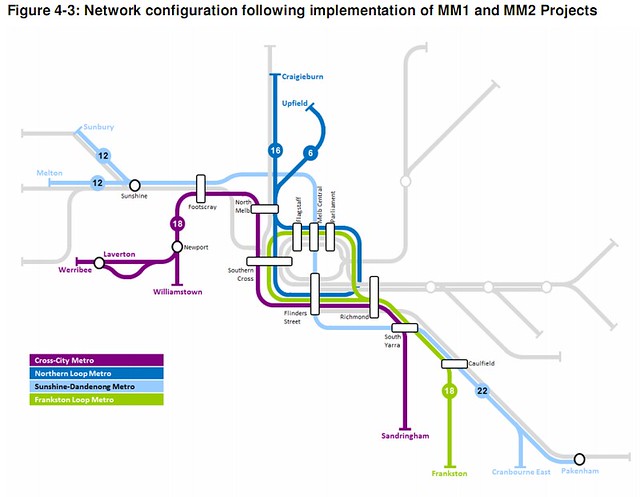
At present, on that pic above, Pakenham/Cranbourne/Frankston all compete for space in the city loop - post Metro the lines would be separated with Frankston having exclusive use of the current loop/underground infrastructure @ 18TPH in peak. Pakenham/Cranbourne would be through-routed on the new metro tunnel to Sunbury and Melton (which requires another electification project from Sunshine along the Ballarat (regional) line). Sandringham would utilise the existing 2 through tracks alongside the city loop and get through-routed to Williamstown and Werribee. Craigeburn and Upfield would get exclusive use of the current Northern Loop which is currently shared with Sydenham (now Sunbury) line - and which up until about 2 years ago Werribee was also using the current loop/underground infrastructure.

The released reports reaffirm what's been reported already - by 2022 all branch lines will have at least 15 minute off peak frequencies and 10 minute peak frequencies, but looking at that diagram and comparing to the current timetable the frequency (peak) increases are massive across the board

2010 timetable: 46 trains per hour (from Craigieburn, Upfield, Melton, Sunbury, Werribee and Dandenong)
With upgrades including RRL: 61 tph
With MM1: 75 tph
With MM1 and Melton electrification/duplication: 80 tph
With MM1 + MM2 including Dandenong line upgrades: 86 tph
With MM1 + MM2 + 9-car trains: 109 tph (equivalent)

What this all means: there's currently 46 trains an hour from the existing Craigieburn, Upfield, Sydenham (Sunbury), Werribee and Dandenong areas going to their respective loops. When the Regional Rail Link project is finished, there'll be capacity for another 15TPH (to 61TPH total), MM1 and MM2 relate to the old proposal of two phase tunnel, but the new state government has made it one phase albeit over a shorter route - a further 15TPH in capacity is added with this tunnel and then further improvements are made when the whole Dandenong corridor is upgraded (which requires a lot of level cross grade separation).

Plus - the Pakenham/Cranbourne (Dandenong) to Melton/Sunbury (Sunshine) section station platforms will all be lengthened (the new metro tunnel will be built with 250m long platforms!) to cater for 9 car trains (we only do 6 car at the moment) so that explains the "equivalent" capacity increase to 109TPH (realistically it'll be 86 actual trains an hour, but as each train will be 1/3 longer than current config the extra capacity is reflected in an equivalent of 109TPH on both groups.

22-26TPH on the new Metro Tunnel route (trains literally start on the western and north western edges, and traverse the whole city to the south east: end to end journeys would be around the 80km mark, broken down:

Peak operations (from docs) on specific routes:

8TPH Sunbury-Cranbourne
8TPH Melton-Pakenham
4TPH Rockbank-Pakenham (Rockbank is on the Melton line)
6TPH Sydenham-Westall or Dandenong (Sydenham is the current terminus of the Sunbury line - until the Sunbury electrification extension opens in November, and Westall is between Dandenong and Oakleigh - both these stations have large train storage and maintenance facilities).

26TPH / train every 2.3 minutes in peak

Off-peak (my assumption based on previously reported frequencies)

4TPH Sunbury-Cranbourne
4TPH Melton-Pakenham
4TPH Sydenham-Westall or Dandenong

12 TPH / train every 5 minutes off peak.

And the Frankston, Werribee/Sandringham, Craigieburn/Upfield frequencies are about double what currently runs in the present timetable!

And that, ladies and gents, is how you turn 100 year old rail corridors into fully fledged metros or "subways" as you call them around these parts.

Just hope they fund the project
Reply With Quote
     
     
  #36  
Old Posted Aug 15, 2012, 12:08 PM
tayser's Avatar
tayser tayser is offline
Vires acquirit eundo
 
Join Date: Mar 2002
Location: Melbourne
Posts: 3,231
Also the current X'Trapolis (the newest train class) trains are in a 2 x 3 car config which have 264 seats / room for 133 standing per 3 car configuration, very much commuter like config, that might change... so total seats in standard 6 car is 794 - so when trains on the Dandenong-sunshine corridor go live, there'll be space for 1191 people per train if the current seat to standing ratio exists (I dare say this will change to be more balanced)

26TPH * 1191 = 30,966 capacity per direction per hour for one track pair (Dandenong-Sunshine)
18TPH * 794 = 14,292 capacity per direction per hour for one track pair to Frankston and using the existing underground loop.
ditto the above for Sandringham-Werribee/Williamstown, and
22TPH * 794 = 17,468 capacity per direction per hour for one track pair to Craigieburn and Upfield using the existing underground loop

30,966 + 14,292 + 14,292 + 17,468 = 77,018 capacity on 4 track pairs per direction per hour. Double it for both directions.

I'm inrterested to know, how does 30,966 per direction compare with other subway lines/systems in N.A?
Reply With Quote
     
     
  #37  
Old Posted Aug 15, 2012, 5:55 PM
zilfondel zilfondel is offline
Submarine de Nucléar
 
Join Date: Mar 2006
Location: Missouri
Posts: 4,477
Thats some insane capacity for trams!

However, the tickets seem very expensive. I balk at paying $2/direction for transit.
Reply With Quote
     
     
  #38  
Old Posted Aug 15, 2012, 9:55 PM
tayser's Avatar
tayser tayser is offline
Vires acquirit eundo
 
Join Date: Mar 2002
Location: Melbourne
Posts: 3,231
That's not tram capacity, it's trains
Reply With Quote
     
     
  #39  
Old Posted Nov 9, 2012, 10:11 PM
tayser's Avatar
tayser tayser is offline
Vires acquirit eundo
 
Join Date: Mar 2002
Location: Melbourne
Posts: 3,231
first render that's been drawn up for the CBD South (Flinders St) Metro tunnel station:

http://www.news.com.au/national/melb...-1226513988549

SWANSTON St will be out of action for up to a year when the iconic thoroughfare is dug up for the Melbourne Metro rail tunnel project.

The Herald Sun can reveal areas near the two new proposed city train stations - CBD North and CBD South - will be worst affected.

One source said the entire width of the impacted stretches of road could be out of action for up to a year.

Construction on the five-stop, 9km tunnel linking the Sydenham and Dandenong rail lines is not expected to start for several years even if planning approval is granted as federal funding is needed.


Reply With Quote
     
     
  #40  
Old Posted Nov 18, 2012, 1:18 PM
tayser's Avatar
tayser tayser is offline
Vires acquirit eundo
 
Join Date: Mar 2002
Location: Melbourne
Posts: 3,231
route of the Regional Rail Link now clearly visible from space

Reply With Quote
     
     
This discussion thread continues

Use the page links to the lower-right to go to the next page for additional posts
 
 
Reply

Go Back   SkyscraperPage Forum > Discussion Forums > Transportation
Forum Jump


Forum Jump


All times are GMT. The time now is 12:49 PM.

     
SkyscraperPage.com - Archive - Privacy Statement - Top

Powered by vBulletin® Version 3.8.7
Copyright ©2000 - 2024, vBulletin Solutions, Inc.