HomeDiagramsDatabaseMapsForum About
     

Go Back   SkyscraperPage Forum > Discussion Forums > Transportation


Reply

 
Thread Tools Display Modes
     
     
  #221  
Old Posted Nov 4, 2012, 5:35 AM
Austinlee's Avatar
Austinlee Austinlee is offline
Chillin' in The Burgh
 
Join Date: Nov 2004
Location: Spring Hill, Pittsburgh
Posts: 13,095
^Love those last two pics.
__________________
Check out the latest developments in Pittsburgh:
Pittsburgh Rundown III
Reply With Quote
     
     
  #222  
Old Posted Nov 6, 2012, 6:07 PM
mrnyc mrnyc is offline
cle/west village/shaolin
 
Join Date: Jul 2006
Posts: 11,749
Quote:
Originally Posted by Austinlee View Post
Well yeah but uhhhh, uhmmm. Sure.
i know, but believe it or not after you get over being stunned speechless...ok that takes a good long while to be sure...but after that and you jump in the entire tokyo metro rail system is actually pretty easy to figure out and use -- i promise lol! there is romaji (roman or english) lettering most places.

if you are leaving the city, the levels of rail service are sometimes a little tougher to parse, but still not too bad (ie., futsuu=local, kyuukou=rapid and tokkyuu=express).
Reply With Quote
     
     
  #223  
Old Posted Jan 7, 2013, 2:41 PM
installers installers is offline
Closed account
 
Join Date: Dec 2012
Posts: 14
Here's Montreal's metro and train lines.

Metro lines go from the middle of the island all the way to the east end. (follow green + orange line).
Montreal Population: 1.86M People, (2011 census)


Last edited by installers; Jan 7, 2013 at 3:43 PM.
Reply With Quote


  #225  
Old Posted Jan 11, 2013, 1:22 PM
Swede's Avatar
Swede Swede is offline
YIMBY co-founder
 
Join Date: Jul 2001
Location: sol.III.eu.se.08
Posts: 6,761
I'd love to show of Stockholm's rail map with the LRT-extension that's opening later this year now added. But it's only on the transit authority's site as a .pdf so here a link:
http://sl.se/ficktid/karta%2Fvinter/...rafik_2012.pdf

Notice how the LRT extension (Alvik-Sudbyberg-Solna) makes the whole layout go from decent to not-even-close-to-ok? I'm hoping they'll introduce a new map before that line opens, but I've yet to hear anything at all about it.
__________________
Forumers met so far:
Huopa, Nightsky, Jo, wolkenkrabber, ThisSideofSteinway, jacksom, New Jack City, LeCom, Ellatur, Jan, Dennis, Ace, Bardamu, AtlanticaC5, Ringil, Dysfunctional, stacey, karakhal, ch1le, Hviid, staff, kjetilab, Þróndeimr, queetz, FREKI, sander, Blue Viking, nomels, Mantas, ristov, Rafal_T, khaan, Chilenofuturista, Jonte Myra, safta20, AW, Pas, Jarmo K, IceCheese, Sideshow_Bob, sk, Ingenioren, Ayreonaut, Silver Creations, Hasse78, Svartmetall
Reply With Quote
     
     
  #226  
Old Posted Jan 21, 2013, 10:51 PM
Wooster's Avatar
Wooster Wooster is offline
Round Head
 
Join Date: Nov 2003
Posts: 12,688
Here's Calgary's LRT system. 2 lines, 4 legs in/out of downtown. The West leg just opened about 6 weeks ago. Map makes it looks small but ridership is about 310,000 daily (1.25 million metro area). There's 44 stations and 56 km (35 miles) of track.


Two more legs (North Central and Southeast), an airport spur and downtown subway tunnel planned. That will bring the system to about 100km of track and about 70 stations. New lines will be complemented by a bevy of BRT and "other" technologies - City is currently contemplating a gondola to span the Bow River Valley connecting the west end of the city to the University of Calgary/Hospital area.

http://www.routeahead.ca/wp-content/...it-network.pdf
Reply With Quote
     
     
  #227  
Old Posted Jan 22, 2013, 5:20 PM
Cirrus's Avatar
Cirrus Cirrus is offline
cities|transit|croissants
 
Join Date: Jul 2001
Location: Washington, DC
Posts: 18,384
Here's an interesting map that shows train headways on DC Metrorail:

__________________
writing | twitter | flickr | instagram | ssp photo threads
Reply With Quote
     
     
  #228  
Old Posted Jan 22, 2013, 6:49 PM
MonkeyRonin's Avatar
MonkeyRonin MonkeyRonin is offline
¥ ¥ ¥
 
Join Date: Sep 2006
Location: Vancouver
Posts: 9,916
A comprehensive map of rail transit for Toronto, showing subway, streetcar, and commuter train service:


The current standard subway map but in Chinese:


Commuter train map:


Comprehensive map for 2020, by which point all the currently U/C projects should be completed:

__________________
Reply With Quote
     
     
  #229  
Old Posted Mar 17, 2013, 5:31 PM
MetroRailRoad MetroRailRoad is offline
Registered User
 
Join Date: Dec 2012
Posts: 50
Here is my citys rapid transit map. Currently, the. SkyTrain has 3 lines. The expo and millenium lines run Bombariar ALRT technology and the Canada Line runs Rotem technology
__________________
My rapid transit site
Reply With Quote
     
     
  #230  
Old Posted Mar 19, 2013, 12:27 AM
photoLith's Avatar
photoLith photoLith is offline
Ex Houstonian
 
Join Date: Feb 2008
Location: Pittsburgh n’ at
Posts: 15,495
Video Link


Pittsburgh Light Rail
__________________
There’s no greater abomination to mankind and nature than Ryan Home developments.
Reply With Quote
     
     
  #231  
Old Posted Apr 29, 2013, 4:45 AM
Royal Scots Grey's Avatar
Royal Scots Grey Royal Scots Grey is offline
Ventis Secundis
 
Join Date: Mar 2013
Location: Clydebank, Glasgow, Scotland
Posts: 15
The Glasgow suburban railway network, the largest in the UK outside London.
Reply With Quote
     
     
  #232  
Old Posted May 16, 2013, 3:11 AM
llamaorama llamaorama is online now
Unicorn Wizard!
 
Join Date: Oct 2008
Posts: 4,212
So I guess Edinburgh never had a ton of suburban trains in comparison?

But then do short rural "intercity" lines in much of Scotland function as commuter services anyways?
Reply With Quote
     
     
  #233  
Old Posted May 18, 2013, 11:51 AM
Royal Scots Grey's Avatar
Royal Scots Grey Royal Scots Grey is offline
Ventis Secundis
 
Join Date: Mar 2013
Location: Clydebank, Glasgow, Scotland
Posts: 15
Quote:
Originally Posted by llamaorama View Post
So I guess Edinburgh never had a ton of suburban trains in comparison?

But then do short rural "intercity" lines in much of Scotland function as commuter services anyways?
Yeah, as there are trains every 15 minutes to and from Waverley from the high level station at Queen Street, 4 tph on the North Clyde Line, a hourly service from Glasgow Central via Shotts and at peak hours only, services to North Berwick from Central. No shortage of options.
__________________
Good men don't need rules.Today is not the day to find out why I have so many.
The Eleventh Doctor
A Good Man Goes to War
Reply With Quote
     
     
  #234  
Old Posted Jul 13, 2013, 6:37 PM
Smiley Person's Avatar
Smiley Person Smiley Person is offline
of the bay area
 
Join Date: Sep 2001
Location: Berkeley
Posts: 1,481
Northeast Rail Map of long distance, commuter, and tourist railroads in the Northeast US
PDF version at http://northeastrailmap.com

Reply With Quote
     
     
  #235  
Old Posted Jul 14, 2013, 12:16 PM
Swede's Avatar
Swede Swede is offline
YIMBY co-founder
 
Join Date: Jul 2001
Location: sol.III.eu.se.08
Posts: 6,761
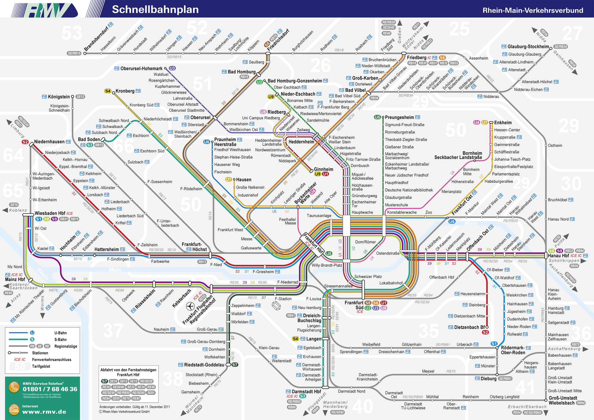
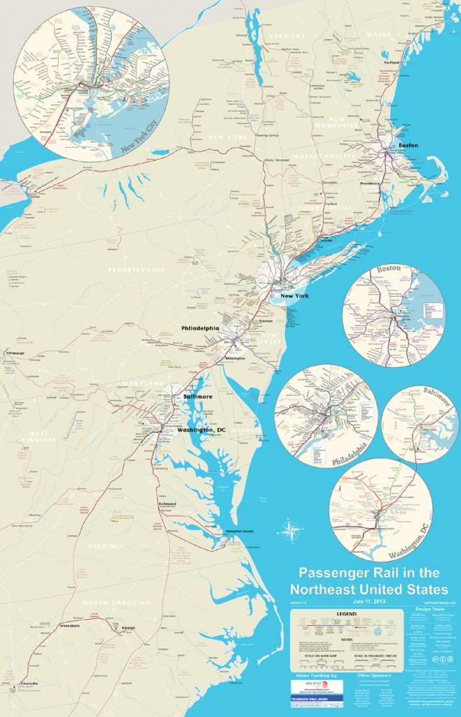
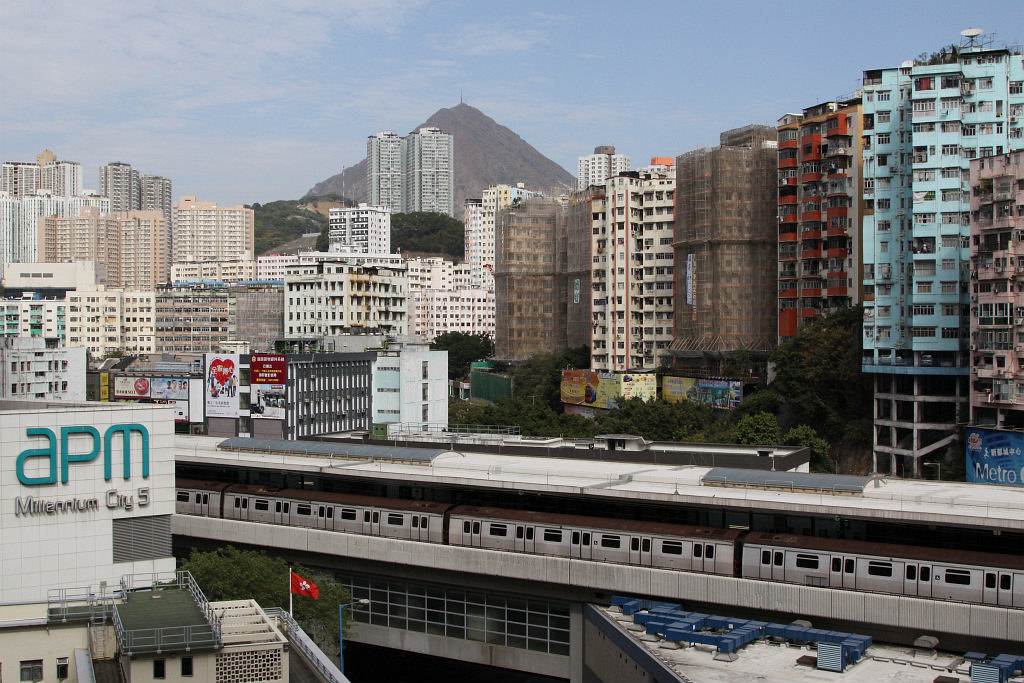
The current generation of LRVs ("A32") and Commuter Trains ("X60") in Stockholm. The next generation of LRV has started delivery and some testing (tho all the A32s are expected to remain in service sine there's an expansion opening soon and an old LRT line getting it's 1940s vehicles replaced). Oh, and yes, there's an interchange stop in the pic, the X60 is blocking us from seeing the Commuter Rail station and the LRT stop is hidden by bridge pillars.


WP_20130714_041 by Gustav Svärd, on Flickr
__________________
Forumers met so far:
Huopa, Nightsky, Jo, wolkenkrabber, ThisSideofSteinway, jacksom, New Jack City, LeCom, Ellatur, Jan, Dennis, Ace, Bardamu, AtlanticaC5, Ringil, Dysfunctional, stacey, karakhal, ch1le, Hviid, staff, kjetilab, Þróndeimr, queetz, FREKI, sander, Blue Viking, nomels, Mantas, ristov, Rafal_T, khaan, Chilenofuturista, Jonte Myra, safta20, AW, Pas, Jarmo K, IceCheese, Sideshow_Bob, sk, Ingenioren, Ayreonaut, Silver Creations, Hasse78, Svartmetall
Reply With Quote
     
     
  #236  
Old Posted Jul 15, 2013, 4:27 AM
cambron J's Avatar
cambron J cambron J is offline
Registered User
 
Join Date: Jul 2012
Posts: 150
Washington Metropolitan Area Transit Authority 129 Mile Area Regional System Track Schematic

Other schematics:
106 Mile Area Regional System Track Schematic Existing system
139 Mile Area Regional System Track Schematic 2030 system, based on a proposal presented to the WMATA board on 04 24 2008. (Note this schematic does not show the revision made to the N route in 129 Mile Area Regional System Track Schematic linked to above.)
__________________
John in the sand box of Maryland's eastern shore.
Reply With Quote
     
     
  #237  
Old Posted Jul 26, 2013, 1:53 PM
alps's Avatar
alps alps is offline
Registered User
 
Join Date: Sep 2006
Location: Hong Kong
Posts: 1,568
Mass Transit Railway, Hong Kong

The MTR comprises 218.2 km (135.6 mi) of rail with 152 stations, including 84 railway stations and 68 light rail stops. It has a daily ridership of about 5 million.


Typical 8-car train arriving at Kwai Fong Station


(source)

Interior of one of the oldest, British-built trains, refurbished in the 1990s.


(source)

Causeway Bay Station. Most Island Line platforms are built inside the bored tunnel, hence the circular shape.


(source)

MTR stations are pretty spartan in comparison to those of other cities, but each has a distinctive bright colour scheme. Tin Hau Station is very orange.


(source)

Kinki Sharyo SP1900 EMU pulling into Sha Tin Station. The East Rail Line links Hong Kong to China and has a maximum capacity of over 101,000 passengers per hour, per direction.


(source)

Many staff on duty to keep the system running safely.


(source)

Train stopped at Kwun Tong Station. This was the original terminus station of the first system segment which opened in 1979.


(source)

Comfy interior of the (overpriced!) Airport Express.


(source)
Reply With Quote
     
     
  #238  
Old Posted Jul 26, 2013, 8:49 PM
inSaeculaSaeculorum inSaeculaSaeculorum is offline
BANNED
 
Join Date: Jun 2013
Location: Los Angeles
Posts: 440
Most recent L.A. Metro map including lines currently planned/under construction:


http://thesource.metro.net/2013/06/1...o-rail-debuts/
Reply With Quote
     
     
  #239  
Old Posted Jul 26, 2013, 9:06 PM
LosAngelesSportsFan's Avatar
LosAngelesSportsFan LosAngelesSportsFan is offline
Registered User
 
Join Date: Oct 2004
Location: Los Angeles
Posts: 7,849
very exciting times with 5 lines under construction at the same time. I wish we could add the 405 HRT, the West Hollywood extension and a glendale / pasadena / burbank line in the near future.
Reply With Quote
     
     
  #240  
Old Posted Jul 27, 2013, 7:15 PM
SpawnOfVulcan's Avatar
SpawnOfVulcan SpawnOfVulcan is offline
Cat Enthusiast
 
Join Date: Apr 2008
Location: America's Magic City
Posts: 3,861
It's still hard to wrap my head around the amount of expansion LA's system is undergoing when many systems sit still. But, of course, the city has a lot of virgin (unserved) space to expand in to, so it makes sense.
__________________
SSP Alabama Metros: Birmingham (City Compilation) - Huntsville - Mobile - Montgomery - Tuscaloosa - Daphne-Fairhope - Decatur

SSP Alabama Universities: Alabama - UAB - Alabama State
Reply With Quote
     
     
This discussion thread continues

Use the page links to the lower-right to go to the next page for additional posts
 
 
Reply

Go Back   SkyscraperPage Forum > Discussion Forums > Transportation
Forum Jump


Forum Jump


All times are GMT. The time now is 1:57 PM.

     
SkyscraperPage.com - Archive - Privacy Statement - Top

Powered by vBulletin® Version 3.8.7
Copyright ©2000 - 2024, vBulletin Solutions, Inc.