 LAPL
LAPL
I'm fascinated by the 1926 aerial shot of DTLA (above) and its layers of history originally posted in this thread by
sopas ej. One can almost see the buildings rising and falling over the decades. This area was my daily environment during the many years I worked at Fifth and Flower as I used to catch my bus home at 5th and Hill. In the mornings I alighted at 6th and Hill, and walked to work west along 6th. The windows of my workroom looked out over this view too. Also, as a kid in the 50's I thought the buildings around the west garden of Central Library, the Sunkist, Richfield, California Club and the library itself constituted the most glamorous group ever (even then I thought I was a member of the Architecture Police). Bear with me while I rabbit on or just skip this post.
The just finished Central Library (Bertram G. Goodhue) sits near the center of the photo, sharing the block bounded by Grand, Flower, 5th and 6th (former site of the 1882 State Normal School), with the 1915 Bible Institute of Los Angeles Building (see another photo below), the original home of the huge, red neon "Jesus Saves" signs, which were sited on the building's two dormitory towers in 1935, angled to face due north and due west. The Biola Building was torn down in 1988 after being damaged (or so they said) in the October 1, 1987 earthquake and replaced by the 550 Hope St Tower (Kohn, Pedersen Fox Associates, 1991).
The other two notable buildings on this block are the still-standing 1927 Mayflower (later Checkers) Hotel, the roof of which just shows beyond the BIOLA and the Hotel Savoy (Morgan, Walls & Morgan, 1919), 6th and Grand, which would disappear under the footprint of the pedestrian Crocker Citizens Bank Building (Wm Pereira, 1969). The new premises of the California Club (Robert Farquhar, 1930) and the Superior Oil Building, later the Standard Hotel (Claud Beelman, 1956), both facing Flower Street, have yet to be built.
 usc digital library
The Bible Institute of Los Angeles (BIOLA) in 1926 looking SE from the south walkway of the new Central Library.

USC digital library, originally posted in this thread by
ethereal_reality
The Superior Oil Building/Standard Hotel (Claud Beelman, 1956) rises at 6th and Flower, Directly across Flower St from the Richfield Building (Stiles O Clements, 1929, demolished 1968). Sixth St looking east.
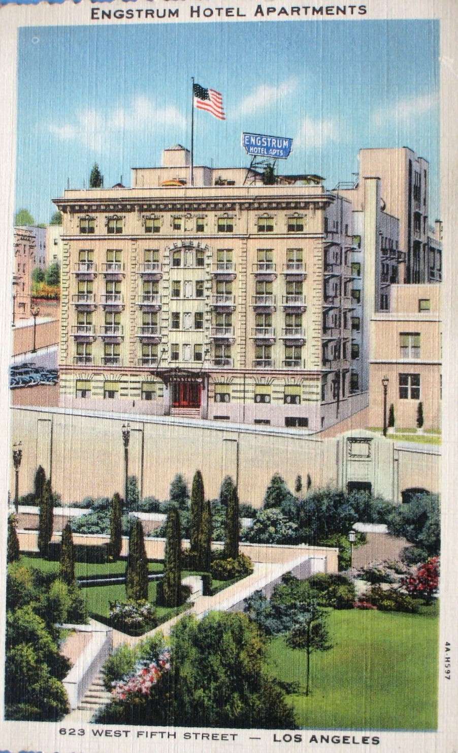
Across 5th street, on the left side of the 1926 photo, the Engstrum Apartments stand at the center of the block; the Edison Building (James and David Allison, 1931) and the Sunkist Building (Walker and Eisen, 1935) have yet to be built on either side of it. The old Bunker Hill steps don't exist yet, let alone the new Bunker Hill steps. The single-story home on the corner of Hope Street and Hope Place appears to be maintained and occupied. The Sunkist Building will be torn down in 1972, eventually replaced by the 444 S Flower Building (originally the Wells Fargo Tower) in 1982. The single-family home and the Engstrum will provide the footprint for Library Tower (Henry N Cobb, 1989). Hope Place will be rerouted behind the Edison Building (One Bunker Hill) and Library Tower to again connect Grand Ave with Hope St.
The seven-story building shown in the photo at top on the corner of 5th and Grand will eventually fall in favor of the Gas Company Tower (SOM, 1991). The massive Subway Terminal Building is beyond, it's narrow eastern front facing on Hill St.
The legit Biltmore Theater (Schultze & Weaver, 1924) stands on the corner of 5th and Grand on the block to the east of Central Library. Notice the bustling activity on the Central Library site to the west (right) in the photo below. The theater was torn down in about 1967 and the site used for street-level parking until the Biltmore Tower (Landau Partnership, 1989) went up.
 LAPL
LAPL
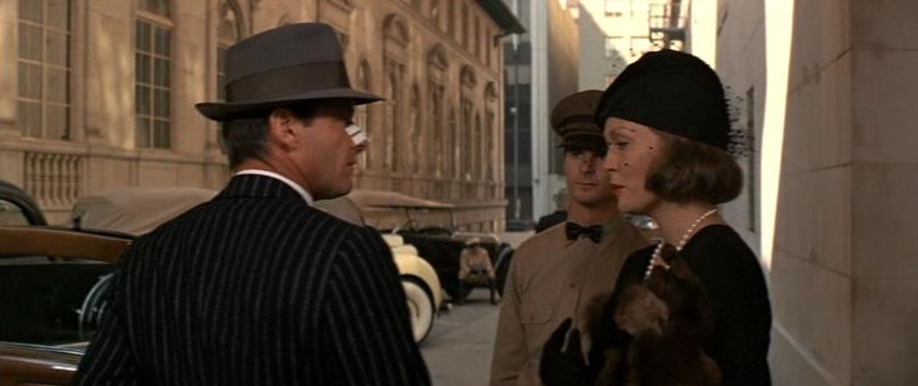
In the 1926 view at top, the Biltmore Hotel (also by Schultze & Weaver, 1923) doesn't have its 1929 addition yet which will change the two bays at the back of the hotel into light wells and bring the building flush with the Grand Ave sidewalk. The limousine drive (now called the VIP Ramp) on the south side of the Biltmore is in place as is the projecting, cantilevered canopy over the VIP entrance at the center of the drive, under which a scene from "Chinatown" (1974) was filmed (see photo below). Over twenty years later a scene for "Se7en" (1995) was filmed at the Grand Ave end of the drive.
 itsfilmedthere.com
Jack Nicholson and Faye Dunaway at the center of the drive at the south end of the Biltmore. The third Pacific Mutual building is on the left. In the distance, across Grand Ave, an incongruous 1969 Crocker Bank building can be seen to the left of the much more appropriate 1927 Mayflower/Checkers Hotel (as has already been pointed out on this thread).
 itsfilmedthere.com
Brad Pitt runs from the Grand Ave end of the Biltmore's limousine lane in "Se7en". One of the great plinth-mounted lanterns which decorate either end of the drive is shown to good effect. The exit ramp from the Pacific Mutual underground parking garage is at right.
A view down and through the Pacific Mutual parking/loading dock ramp is provided by "48 Hours" (1982){
 youtube
One could used to use the Biltmore drive as a pedestrian shortcut, but starting in the late 1990's or thereabouts gates were installed across the dive and kept locked. In the mid 1980's or so, the of-little-faith Biltmore turned its back on Pershing Square and relocated its entrance and lobby to Grand Ave. With the gentrification of the Historic Core, I'm counting the days until the Biltmore reverses that decision.
Completing the block, the three buildings that make up the Pacific Mutual Insurance complex were all in place by the time of the 1926 photo at top. The first, at the corner of 6th and Olive, was built by Parkinson and Bergstrom in 1908 (later remodeled by Parkinson). The 12-story building to the west of that was added in 1922 by Dodd and Richards and the final two-story building (containing one of LA's first underground parking garages) in 1926, running adjacent to the Biltmore's limousine lane in the interior of the block.
 PC image from uncanny.net
The six-story, Corinthian-columned, original Pacific Mutual Building backed by the 12-story annex in circa 1924. The heroic sculptural group over the entrance to the annex was done by Jo Moro who was equally famous as a humorous cartographer (you might want to Google his 1942 map of LA if you aren't familiar with it already). The Savoy Hotel stands beyond the Annex at 6th & Hope.
 youarethere.com
The original 1908 Pacific Mutual Building after John Parkinson's 1936 remodel of his own work.
Again in the 1926 photo at the top of this post, one can just see the Auditorium Building, still with its original, fanciful roofline (Charles F Whittlesey, Otto H Neher, 1906), beyond the NE corner of the Biltmore, built on the site of the old 1887 Hazard Pavilion. The low dome of the main auditorium is visible at the center of the building's roof. It was demolished in 1985. Street-level parking has occupied the the site ever since. The location would be my choice for a Museum of Los Angeles (we could all run it).

billyspostcards.com
The Auditorium Building's organization was strongly influenced by Adler & Sullivan's 1889 Auditorium Building in Chicago (now Roosevelt University).
 ulwaf.com
The Auditorium Building after its 1938 moderne remodel by Claud Beelman (some sources credit Stiles O Clements, I don't know which is correct). An unsightly billboard has been added to the roof in this circa 1960's-1970's view. The Title Trust and Guarantee Building (Parkinson & Parkinson, 1930) is on the right.
Also in the 1926 view at the top of this post, one can see the low buildings on the east side of Pershing Square. These have all been cleared. It's unfortunate that the undistinguished International Jewelry Center Building went up in 1981 at the southern end of this site b/c, in my humble opinion, the land between Hill St and Lindley Place should have been used for an annex to Pershing Square, thereby finally making it an actual square and giving room for much needed public amenities.


 Prev
Prev


 Bottom seven images from


 GoogleSV


 Please tell.


 Thanks Cyberider for sharing. Interesting stories. Now I am anxious to see before pictures!


 Linear Mode
