Probably my favourite historic map of Toronto aside from fire insurance plans. It actually shows the built up areas by land use - which was very rare for maps of those days. Note how much further out platted streets go. Circa 1915:
Images are too massive to post - not sure if there is a way to easily post a smaller image?
And the best site for historic online mapping of the city - showing fire insurance plans up till 1924 and 1947 imaging. This is a really comprehensive site:
This is going to be a bit big, but I've fallen in love with this map already. Needs to be posted so you can see all the juicy detail.
Map of the Northwest Territory, commissioned for the Canadian Almanac of 1870. There was basically no European settlement of any sort in Southern Alberta at this point
(Alberta didn't even exist as a concept)... Fort Calgary was established later in the decade (by the Northwest Mounted Police) to try and halt the illegal whiskey trade from
Montana.
Bow City, Alberta, was incorporated as a village on July 13, 1914 (just two weeks before the outbreak of WWI) and dissolved on April 17, 1918. All that remains of the settlement, about 30km southeast of Brooks, is a solitary signpost. Hopes of developing the village were oriented around a railway to connect the local coal mine to Canadian markets, but the rails never arrived. There is believed to be a buried meteorite under the townsite.
This is going to be a bit big, but I've fallen in love with this map already. Needs to be posted so you can see all the juicy detail.
Map of the Northwest Territory, commissioned for the Canadian Almanac of 1870. There was basically no European settlement of any sort in Southern Alberta at this point
(Alberta didn't even exist as a concept)... Fort Calgary was established later in the decade (by the Northwest Mounted Police) to try and halt the illegal whiskey trade from
Montana.
This one is pretty big, so in a spoiler tag it goes...
British North America circa 1829 (the one I posted on the previous page was from 1795). You can see that by this date, the western edge of the United States stretches way up into British Columbia, and Alaska is just "Russian Territory." Present in British North America are regional names like Athabasca, Knistineaux, New South Wales, East Main, Labrador, Upper Canada, and Lower Canada. The Rocky Mountains are the Stony Mountains. California is still part of Mexico. "St. John" spills straight over the map border.
A few maps of the shifting boundaries of the French Shore of Newfoundland.
Ironically, the French Shore is actually a symbol of France's loss of Newfoundland:
Quote:
The Treaty of Utrecht, signed in 1713, required the French to abandon their settlements in Newfoundland, including their capital at Plaisance, numerous fortified towns, and the islands of St. Pierre and Miquelon.
Quote:
They were not allowed to inhabit this so-called "French Shore" but they were allowed to fish there, and in this way they preserved the Newfoundland fishery's economic advantages as a source of employment and trade, as well as its perceived strategic role as a foundation for French naval power, by transforming Frenchmen into seasoned mariners (Newfoundland as a "nursery for seamen"). So important was preservation of its fishery at Newfoundland to France that in 1762, at a point during the Seven Years' War when France had suffered a string of devastating defeats, the French government insisted on continuing to fight a losing war rather than agree to peace terms, which would have brought the French fishery at Newfoundland to an end. The importance of maintaining a French role in the Newfoundland fishery is also reflected in the way in which France continued to direct military assaults on Newfoundland in 1762 and 1796, and threatened to do so during the American Revolution as well. Though none of these efforts were very successful, France did manage to reaffirm its Treaty Shore privileges, thereby preserving its right to fish not only out of St. Pierre but directly on extensive portions of the coast of Newfoundland itself.
The French Shore did undergo one important revision in 1783. By then, the spread of English settlement into Notre Dame Bay had become a source of friction with French fishermen. England and France therefore agreed to shift the boundaries of the French shore westward; from 1783 until 1904, the French Shore extended from Cape St. John west, around the Northern Peninsula and all the way down to Cape Ray. Earlier, in 1763, the islands of St. Pierre and Miquelon had also been restored to the French. Those islands became the focus of the French banks fishery, with an indigenous "dry" cod fishery as well; the French Shore was used primarily by seasonal fishermen from France to produce cod for the international saltfish trade. As a result, French fishermen maintained a persistent though localized presence in Newfoundland right into this century. Those operating from St. Pierre and Miquelon (both the residents of those islands and the fishermen who came each season from France) developed strong commercial and cultural associations with Newfoundland residents of the Burin Peninsula and the South Coast. The trade in bait was particularly important in the nineteenth century. Similarly, on the French Shore, there was much interaction between the growing residential population and the seasonal French fishery. Though trade between the French and the inhabitants was forbidden by the provisions of the French Shore treaties, in fact French traders regularly provided locals with provisions and fishing gear in exchange for lumber and bait.
Nevertheless, the French presence on the French Shore decreased dramatically as the 19th century wore on. Where once, in the late 1820s, more than 9,000 French nationals had fished on the French Shore, only 133 French fishermen showed up in 1898. The French government was therefore willing in 1904, as part of a general diplomatic settlement of English and French issues throughout the world, to terminate its "French Shore" fishing privileges.
__________________ Note to self: "The plural of anecdote is not evidence."
This is going to be a bit big, but I've fallen in love with this map already. Needs to be posted so you can see all the juicy detail.
Map of the Northwest Territory, commissioned for the Canadian Almanac of 1870. There was basically no European settlement of any sort in Southern Alberta at this point
(Alberta didn't even exist as a concept)... Fort Calgary was established later in the decade (by the Northwest Mounted Police) to try and halt the illegal whiskey trade from
Montana.
I like the proposed railway line going through Calgary before Calgary exists, not the story they tell in edmonton!
__________________ The human ability to innovate out of a jam is profound. That's why Darwin will always be right and Malthus will always be wrong - K.R.Sridhar
‘I believe in science’ is a statement generally made by people who don’t understand much about it. - Judith Curry, Professor Emeritus GIT
The street grid/layout in the same area is almost completely identical today, although most streets have since changed their names. "Store Street" is the old (pre-1830-ish) name for Princess Street, for example.
__________________
"It is only because the control of the means of production is divided among many people acting independently that nobody has complete power over us, that we as individuals can decide what to do with ourselves." - Friedrich Hayek
"Line of fortifications 1812"? That 1790 map reminds me of my authentic Roman coin dated 34 BC
The map isn't actually from 1790. I think it was drawn around 1860 or so using historical sources and city documents and such to figure out what properties had been built in 1790 and which roads and lots had been surveyed and named at that time. The 1812 fortification were thrown in there as a reference.
__________________
"It is only because the control of the means of production is divided among many people acting independently that nobody has complete power over us, that we as individuals can decide what to do with ourselves." - Friedrich Hayek
Probably my favourite historic map of Toronto aside from fire insurance plans. It actually shows the built up areas by land use - which was very rare for maps of those days. Note how much further out platted streets go. Circa 1915:
Cool! I never realized that the Bloor-Danforth subway between Victoria Park and Kennedy was built on the old Canadian Northern ROW. If only they would have kept that land cleared all the way to Malvern...
I used to collect maps fairly intensively. You can get quite good maps for a few hundred dollars: it's a relatively economical collecting hobby. The only thing is what exactly you do with them all.
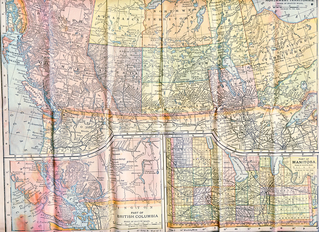
This is an example of a map that would have been cheap in its own day but which is now exceedingly hard to find -- a fold-up map that a fellow heading out west would have bought to stick in his pocket during the train trip. It is part of a double-sided map of Canada from "The Matthews-Northrup Up-To-Date Map" series, which would have been from the U.S. As I noted on Flickr, it gives the longitude in degrees west from Washington DC, as the Greenwich standard had not then been universally accepted. These pocket maps tended to wear out and be thrown away so it was nice to find this one in pretty decent condition.
As a map, it gives a good sense of the organization of the Prairie Provinces in the 1890s, although the mapmaker doesn't quite seem to have grasped that Athabasca, Alberta etc. were divisions of the North West Territory rather than separate from it. It is always interesting to contemplate that parts of Manitoba were once "Saskatchewan" and that Medicine Hat and area originally went with Regina, only being tacked on to "Alberta" at the last minute.
__________________
crispy crunchy light and snappy
I used to collect maps fairly intensively. You can get quite good maps for a few hundred dollars: it's a relatively economical collecting hobby. The only thing is what exactly you do with them all.
This is an example of a map that would have been cheap in its own day but which is now exceedingly hard to find -- a fold-up map that a fellow heading out west would have bought to stick in his pocket during the train trip. It is part of a double-sided map of Canada from "The Matthews-Northrup Up-To-Date Map" series, which would have been from the U.S. As I noted on Flickr, it gives the longitude in degrees west from Washington DC, as the Greenwich standard had not then been universally accepted. These pocket maps tended to wear out and be thrown away so it was nice to find this one in pretty decent condition.
As a map, it gives a good sense of the organization of the Prairie Provinces in the 1890s, although the mapmaker doesn't quite seem to have grasped that Athabasca, Alberta etc. were divisions of the North West Territory rather than separate from it. It is always interesting to contemplate that parts of Manitoba were once "Saskatchewan" and that Medicine Hat and area originally went with Regina, only being tacked on to "Alberta" at the last minute.
When I moved out on my own, one of the things I wanted was an old map of Canada for wall art.... so I scoured Ebay, found this, and had it framed. It's from 1903 and has the sub-territorial Districts of the Northwest Territories as well; at this time Regina would have been the capital of the NWT, governed from this...
The Territorial Administration Building still standing in Regina (though I believe it used to be slightly larger/had a few more buildings):
I actually think I mentioned the map a while ago somewhere on SSP, but never got around to taking some pics... In any case, here is a normal size of the map:
And for those that are of a mind.... the much, much, much larger (you've been warned), more detailed versions for your perusal, though not everything is clear, but good enough for 1:40AM...
Large Canada
The West
The East
The North East + Newfoundland
As I'm sure SHH will enjoy... close-up of the Newfoundland inset
Interesting to see on the map what looks like the attempt of Ontarians to establish the county system in Manitoba.
Yes, it would have been taken for granted that every province was divided into counties. The counties were abandoned around this time, but you can still see the Beautiful Plains County Court building in Neepawa, for example.
__________________
crispy crunchy light and snappy
When I moved out on my own, one of the things I wanted was an old map of Canada for wall art.... so I scoured Ebay, found this, and had it framed.
That's very nice ... good framing job. The nice thing about these is that everything changed very quickly in those times so you learn a lot of different things from maps that are just a few years apart. This one has the competing Alaska-Canada boundary claims, for example, plus in 1903 a lot of hopeful brand-new "towns" would be shown in Sask/Alta that never came to very much, or anything. I see "Glen Adelaide", Sask., for example -- I've not come across it before but it appears to exist today as a cemetery only, as is often the case.
__________________
crispy crunchy light and snappy


 Prev
Prev


 Linear Mode
