ok folks, this is how it works.
The US CSA counts are VERY generous, and getting increasingly so. It's basically a case of different
metro definitions.
They count the urbanised sprawl, but then started counting commuting rates from immediate satellite towns. This could be as low as 10%. We'll call this
Metro 1 stage. from back in the early noughties.
Then they widened it to include the satellite towns that commuted to the next town along (as opposed to the centre city), then enlargened it again to 'might aswell-add-on' their respective counties. By this stage the catchment area became huge, with thousands of km encompassing large swathes of farmland and forest, or in the case of LA, mountain and desert too. NYC even included Pike/ Pitt? County on the grounds that they were receiving the NYC TV signal (though I don't know why they wouldn't just use the commuting criteria as that would have made it). This we'll call
Metro 2 and 3 stages.
Then they added
again even more towns along, effectively
doubling even that ginormous area.
In short less than 1-3% commute into the actual old city limits, and the area verging on the size of mainland Scotland or Serbia by this stage.
Metro 4 stage
European counts do not take commuting into account - but if they did, well the Blue Banana is the densest network of urbanity in the world, and bearing in mind youre only counting the commuting between small towns, it would stretch into Italy, including just as 'short' hops across you know, a sea or mountain chain.
The same area of NYC CSA over the London-SE England- E England (both 20,000 sq km) catchment that the Greater London Authority uses in it's London Plan is about the same. 21 million by now for the London 'mega-region'
http://www.america2050.org/Healdsbur...e_pp_59-67.pdf
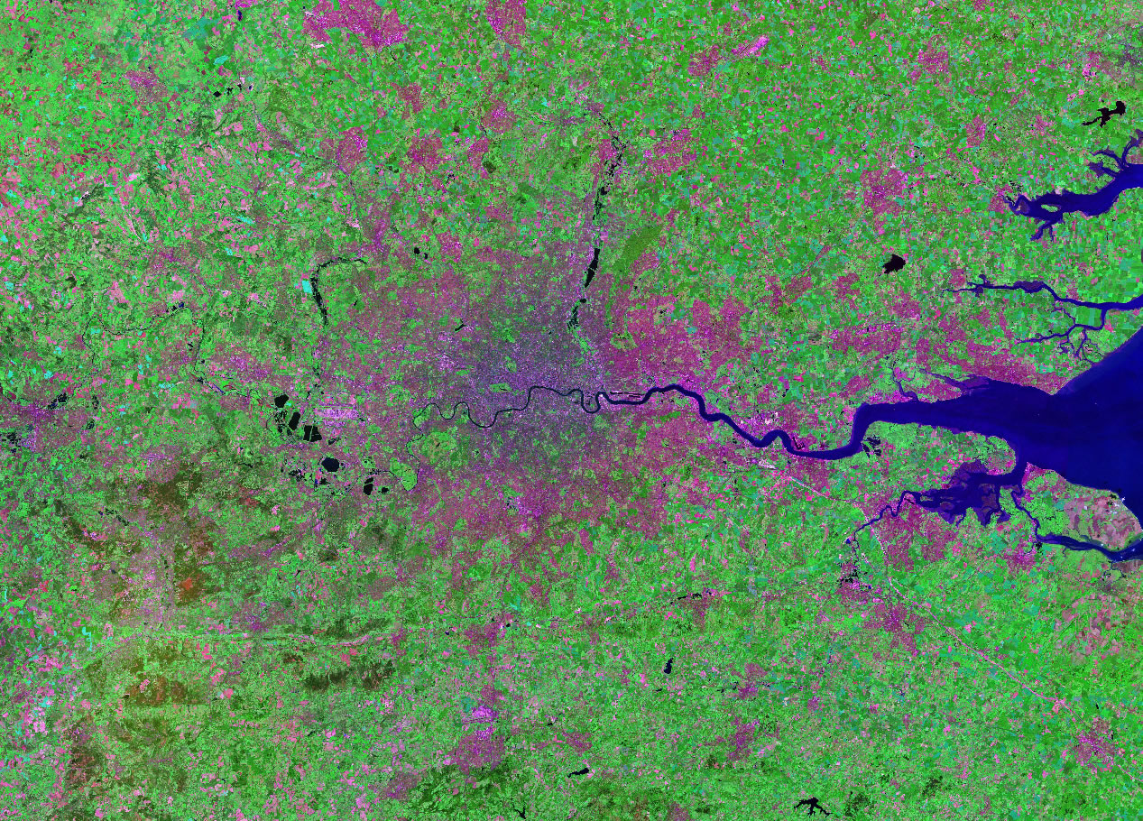
The density of 'commuter-hoods' (new developments in light pink) created by the Green Belt - note the absolute density of them and the utter failure of the Green Belt. This would be the London equivalent to Metro 1 stage - immediate satellite towns and dormitory developments. London forces it's sprawl into a peppering of high density developments, whereas across the pond it's blanket suburbia. In this regard NYC is undeniably the higher count for a contiguous city - 16.7 million as opposed to 12 million, but that depends if you want to discount the commuter peppering as 'suburbs' or not:
 http://geology.com/world-cities/lond...ed-kingdom.jpg
This is the metro 2-3 stage - including the proper (read: larger regional) satellite towns not just the immediate ones in the vicinity. This is the most used 'metro' when we talk about the London metro area, but not the one for NYC. NYC would at this stage be at 18 million and London at 15 million.

This is the metro 4 stage - including every town that commutes into the next one, and their respective counties thrown in for luck. In London they refer this as the mega-region, in NYC it's just NYC metro. To reiterate both are at the 20,000 sq km stage by now and equally dense, and the numbers have now 'levelled off' with 21 million for both cities:


 Prev
Prev


 (What?)


 I'm sure it has been posted about a hundred times on this forum by now
  (it's all good though).

 Linear Mode
