HomeDiagramsDatabaseMapsForum About
     

Go Back   SkyscraperPage Forum > Discussion Forums > City Discussions


Reply

 
Thread Tools Display Modes
     
     
  #1  
Old Posted May 25, 2018, 4:28 PM
hauntedheadnc's Avatar
hauntedheadnc hauntedheadnc is online now
A gruff individual.
 
Join Date: Aug 2003
Location: Greenville, SC - "Birthplace of the light switch rave"
Posts: 13,416
The City Plan Appreciation Thread

When it comes to the way cities grow and flow, there are three types: Cities that grew with no plan whatsoever; cities that grew on a boring, slapdash grid; and cities that grew according to someone's dream.

An example of a city that grew without a plan of any kind would be Boston, whose downtown streets are basically old, paved cowpaths. A gridded plan for Boston didn't come until much later. My own city is another, and there is at least one neighborhood here where the developer laid out the streets by setting a horse loose on the property and following where it went, with the thinking being that a horse would choose the paths of least resistance.

An example of a city that grew on a grid would be Chicago or Toronto, whose street grids were put in place to facilitate fast growth without fuss, bother, or frippery. Grids work just fine, and can -- and usually are -- altered and decorated at a later date, as New York did with Central Park and Chicago did with its lakefront, but grids are utilitarian. There's no artistry to a grid, and in the case of Toronto and Chicago, there's not even as much coherence as you'd expect from a pure grid.

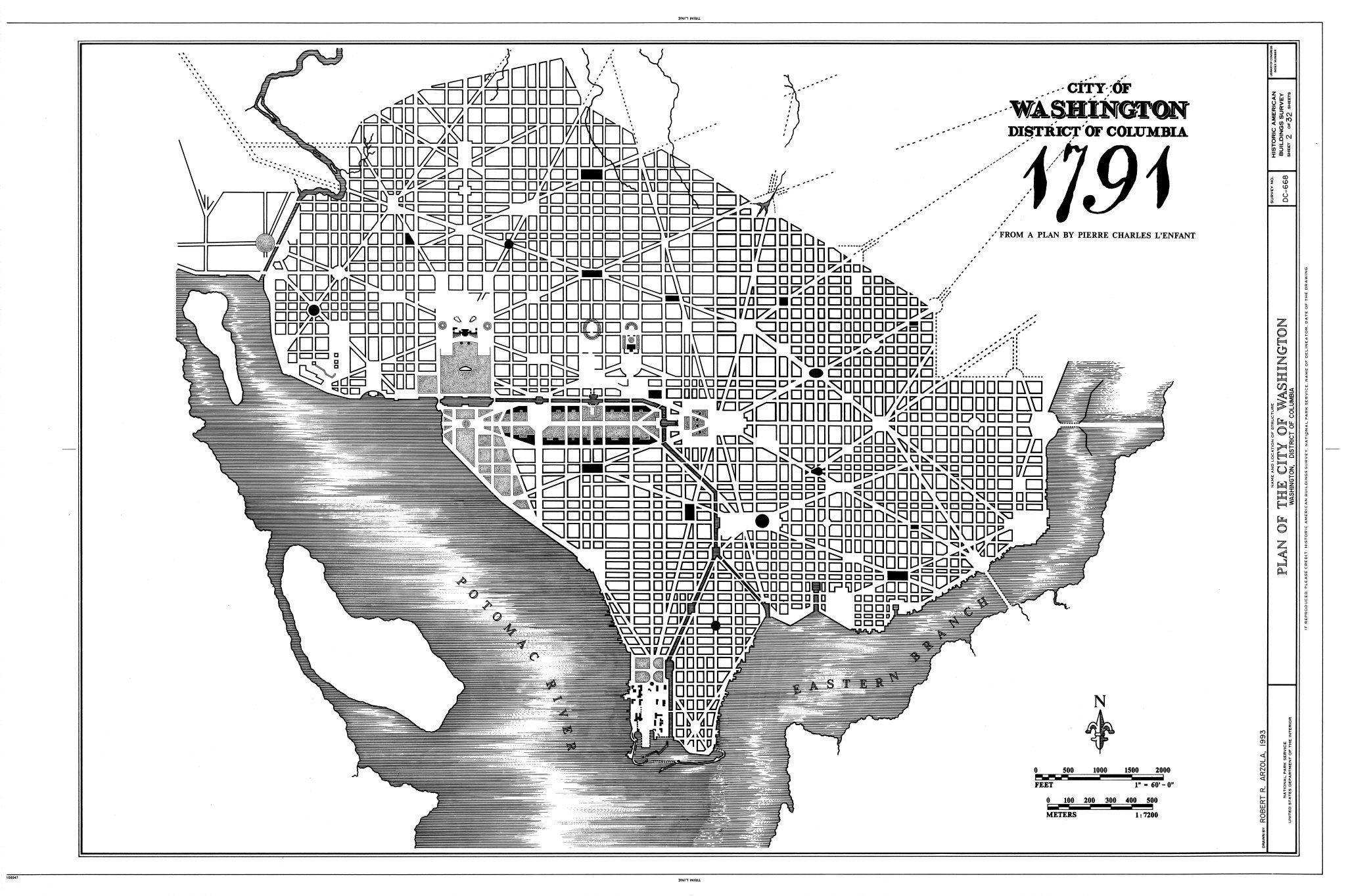
And an example of a city that grew on a plan would be Washington, with an elegant pattern of diagonals and radials, parks built right in from the beginning, and space for strategically grand monuments. Barcelona and Paris are other famous examples of great city planning in action, as are plenty of areas in all the cities I've already mentioned. That being said, this is the place to talk about really great city and neighborhood plans. Hopefully, we can even mention some of the more obscure ones.

Take, for example, Kingsport, Tennessee. Note the coherence of downtown, and how the layout, like a fanlight window, is unique without being gimmicky. You have a broad Broad Street interrupted by traffic circles where public art is displayed, anchored at both ends by civic and cultural institutions. To the south is the old train station, a lovely building, and to the north are the grand churches on Church Circle. This is a good plan with room for growth and expectations of greatness, even if the city has turned its back on downtown.

Some of the other planned cities that I can think of off the top of my head are Columbia, SC; Raleigh, NC; Savannah, Augusta and Macon, GA; and Erie, PA. Sometimes these cities' plans grew with the city as they did for a time in Savannah, and other times a city, like Raleigh, quickly outgrew its plan and went sprawling hell for leather across the countryside leaving its old planned heart behind.

Let's talk about these plans!
__________________
"To sustain the life of a large, modern city in this cloying, clinging heat is an amazing achievement. It is no wonder that the white men and women in Greenville walk with a slow, dragging pride, as if they had taken up a challenge and intended to defy it without end." -- Rebecca West for The New Yorker, 1947
Reply With Quote
     
     
  #2  
Old Posted May 25, 2018, 4:40 PM
JManc's Avatar
JManc JManc is online now
Dryer lint inspector
 
Join Date: Feb 2003
Location: Houston/ SF Bay Area
Posts: 37,918
__________________
Sprawling on the fringes of the city in geometric order, an insulated border in-between the bright lights and the far, unlit unknown. Subdivisions
Reply With Quote
     
     
  #3  
Old Posted May 25, 2018, 5:15 PM
Pedestrian's Avatar
Pedestrian Pedestrian is offline
Registered User
 
Join Date: Dec 2016
Location: San Francisco
Posts: 24,177
San Francisco grew oprganically but it grew on a rigid grid which, in this case, given the city's hilly topography, didn't make a lot of sense (and caused some problems with horse cars getting up most of the hills leading to the development of cable cars):


https://www.archives.gov/publication...arthquake.html

But in the wake of the 1906 earthquake, city leaders sought a grand plan for rebuilding and got one from noted Chicago architect Daniel Burnham:

Quote:
Most of the street grid was left intact, but it would be sliced by wide diagonal boulevards that linked otherwise isolated districts to the grandest path of all, "a broad, dignified and continuous driveway skirting the water edge and passing completely around the city."

Along much of the bay, the boulevard would be on a new seawall with public beaches to the east, and new docks for the port to the west. On the northern waterfront, where finger piers already poked into the bay, the boulevard would rise up and run on top of the warehouses -- providing "an extensive line of fireproof storage" as well as a vantage point from which to "study the effects of sunshine and shadow on islands and mountains seen through the masts of ships."

Burnham also emphasized the scenic drama of the city's hills. He proposed that Bernal Heights and Potrero Hill be terraced with lavish plantings on their slopes and playgrounds on top; Telegraph Hill would be wrapped in classical buildings and crowned by "a monument symbolical of some phase of the city's life."
Twin Peaks received the most spectacular treatment of all.

The plan called for an "amphitheater or stadium of vast proportions" as well as an atheneum with columns and other classical flourishes and -- as a sort of exclamation point near one peak -- "a colossal figure symbolic of San Francisco."

On the west slope, stretching down to Lake Merced through rolling hills, Burnham proposed a single open space of 4,764 acres. By comparison, Golden Gate Park is 1,017 acres. It would be a series of reservoirs tumbling through illuminated landscapes: "not only a public park," Burnham wrote, "but a center for great public fetes."
https://www.sfgate.com/bayarea/place...ns-2537355.php


https://upload.wikimedia.org/wikiped..._Francisco.jpg

Burnham's vision for Telegraph Hill:


http://www.socketsite.com/archives/2...francisco.html

But everybody was in a hurry to rebuild and started right away replacing structures as and where they had been. Ultimately the plan was ignored.
Reply With Quote
     
     
  #4  
Old Posted May 25, 2018, 5:17 PM
dubu's Avatar
dubu dubu is offline
Registered User
 
Join Date: Apr 2012
Location: bend oregon
Posts: 1,449
are there any citie with a octagon in the middle so you can have eight tran lines going outward from the octagon? i think downtown there shouldnt be cars or there shouldnt be trains underground because thats where the most people are, you shoul have trains be the main part. the buildings are second then you got to have some nature.

theres a pic of it on the last page of if a city was built around bikes. its not that great of a thread though.
Reply With Quote
     
     
  #5  
Old Posted May 25, 2018, 5:23 PM
mr1138 mr1138 is offline
Registered User
 
Join Date: Nov 2004
Posts: 1,059
Now this is the kind of conversation that can keep me interested for days!

One initial thought would be to point out that it isn't ENTIRELY accurate to say that Boston was created without a plan. When I did research for a college capstone project on "organic" city street grids, I learned that Boston was actually platted in the same way as all Massachusetts towns during the Puritan era.

Basically, the way it worked, was that a main road (modern day Washington St) was built along the top of the highest continuous ridge in town, and properties were platted out in long skinny lines extending down the hill from that point. This was meant to be an agrarian town pattern, including the "common" cattle grazing meadow, and presumably the early founders didn't anticipate the town becoming a major city. Because this was based on topography, the original main street and corresponding lots do not follow a grid. Due to years and years of additions to the city, reclamation of the bay, the leveling of some hills, and further subdivision of individual properties, this pattern has long since been obscured.

Reply With Quote
     
     
  #6  
Old Posted May 25, 2018, 10:41 PM
muertecaza muertecaza is online now
Registered User
 
Join Date: Oct 2015
Posts: 2,230
No one would ever accuse Phoenix of being conceived as a grand plan.

Phoenix was founded by an Confederate solider and (later) alleged highway robber, Jack Swilling, who wanted to revive the old Hohokam canals for farming. When enough settlers had migrated to justify selecting a townsite, Swilling offered his farm, but got beat to the punch by other settlers that favored 320 acres that make up the current CBD to this day.

They surveyed the townsite and established a grid 1 mile long and 1/2 mile wide, in blocks 100 feet wide.

https://web.archive.org/web/20130405...ory/index.html


https://en.wikipedia.org/wiki/Histor...poration_(1881)
Reply With Quote
     
     
  #7  
Old Posted May 26, 2018, 12:17 AM
Sun Belt Sun Belt is offline
BANNED
 
Join Date: Sep 2017
Location: The Envy of the World
Posts: 4,926
Quote:
Originally Posted by hauntedheadnc View Post
When it comes to the way cities grow and flow, there are three types: Cities that grew with no plan whatsoever; cities that grew on a boring, slapdash grid; and cities that grew according to someone's dream.

An example of a city that grew without a plan of any kind would be Boston, whose downtown streets are basically old, paved cowpaths. A gridded plan for Boston didn't come until much later.
That's not entirely accurate. Boston's streets were planned and laid according to the land that existed at the time. Rewind time and look how the streets interacted with water. They were placed to have streets run perpendicular to the waterfront of the time. As the city grew and became over crowded, the city filled in massive amounts of wetlands, bays and the harbor [this would be illegal today due to environmental regulations].

The streets that once made some sense, suddenly did not.
Reply With Quote
     
     
  #8  
Old Posted May 26, 2018, 10:29 PM
PoshSteve's Avatar
PoshSteve PoshSteve is offline
Registered User
 
Join Date: Jul 2011
Location: Cleveland OH!
Posts: 187
My current city, where I'm proud to say I just purchased my first home, was a master planned community built around two light rail lines: Shaker Hts, OH. The trains gave birth to the city, creating a speedy connection to the heart of downtown Cleveland. While most of the city is comprised of large single family mansions, there are high concentrations of condos at the main stations, particularly along Van Aken Blvd. The importance of transit is still realized today with the transit-oriented redevelopment of the Van Aken District. Two suburban strip centers and a car dealership are being replaced by a large high density/mixed use development at the end of the Blue Line at Van Aken Blvd and Warrensville Center Rd. The first phase of offices, apartments, retail and a food hall is starting to open this month.

History of Shaker Hts
Reply With Quote
     
     
  #9  
Old Posted May 26, 2018, 11:02 PM
The North One's Avatar
The North One The North One is offline
Registered User
 
Join Date: Sep 2009
Posts: 5,512
The Boston cow path thing is a myth.
__________________
Spawn of questionable parentage!
Reply With Quote
     
     
  #10  
Old Posted May 27, 2018, 12:52 AM
proghousehead proghousehead is offline
Registered User
 
Join Date: Oct 2006
Posts: 183
Manhattan below 14th street is as haphazard as Boston or London. The grid is overstated and only overtly rigid between 14th and 110th street (basically 5 miles).
Reply With Quote
     
     
  #11  
Old Posted May 27, 2018, 5:44 AM
mr1138 mr1138 is offline
Registered User
 
Join Date: Nov 2004
Posts: 1,059
Quote:
Originally Posted by The North One View Post
The Boston cow path thing is a myth.
Yes - this has already been said in two different ways.

I think that the reality is that no city is ever completely planned in a uniform way. All city grids are actually the result of the phenomenon of "palimpsest," or layering of different planned elements over time.

I would suggest that there is really no such thing as hauntedheadnc's suggestion that there are some "Cities that grew with no plan whatsoever." Or alternately, we could also say that EVERY city has grown with no overarching plan. Instead, I would say that what we see as "chaos" is in fact the unplanned layering of different kinds of plans over time.

I would suggest, instead, that there are a different three kinds of city plans:

1) Based on topography or existing natural features, aka Boston's original plat with lots that ran perpendicular between the bay and the highest ridgeline. Or cities that were built according to much older land ownership patterns - patterns that themselves go back to older natural patterns, like where certain vegetation may have been growing due to particular micro-climates or sun exposure, and resulted in rural landownership patterns (like most of the European countryside).
2) Geometric plans. These could be grid-based, or something different such as radial geometry (like Woodward's plan for Detroit). Other examples could include Haussman's Boulevards, which connect together important locations in the city, or something like L'Enfant's plan for DC.
3) The "Planned Picturesque," which is the deliberate attempt to design patterns that appear naturalistic, but actually aren't. A good example would be Siena Italy's Via Citta, or the town plan for Riverside Illinois by Frederick Law Olmstead (or many modern American suburbs, for that matter).

Anything that we interpret as being "unplanned," can actually unpacked as being the layered result of two or more of the previous three examples. This is the "palimpsest."

Boston, for example, began as a topographically based plan, which became warped over time as land was reclaimed, hills were moved, and lots were subdivided at different times and for different reasons. Paris, similarly, cannot be said to be a 100% geometric vision of Baron von Haussman, but is in fact a much older medieval composition that had Haussman's geometric system of Boulevards layered on top. In Washington DC, certain elements didn't come together as Le'Enfant planned (like Virgina Ave SE, which became a railroad and freeway ROW). And even in NYC, with its "perfect" grid, we can see elements that predate, or don't conform to this grid - much as proghousehead just pointed out (Lower Manhattan's plan was topographic in nature, and Broadway is an even older element that breaks from the supposed "perfection" of the midtown grid).

Last edited by mr1138; May 27, 2018 at 6:17 AM.
Reply With Quote
     
     
  #12  
Old Posted May 27, 2018, 8:09 AM
Encolpius Encolpius is offline
obit anus, abit onus
 
Join Date: Jun 2011
Location: London
Posts: 803
Quote:
Originally Posted by mr1138 View Post
3) The "Planned Picturesque," which is the deliberate attempt to design patterns that appear naturalistic, but actually aren't. A good example would be Siena Italy's Via Citta...
Do you mean this street, the Via di Città?


What do you mean? Why is it an example of what you're talking about?
Reply With Quote
     
     
  #13  
Old Posted May 27, 2018, 2:57 PM
mr1138 mr1138 is offline
Registered User
 
Join Date: Nov 2004
Posts: 1,059
Quote:
Originally Posted by Encolpius View Post
Do you mean this street, the Via di Città?


What do you mean? Why is it an example of what you're talking about?
I would have to go back and uncover my original research to find exact names and dates (I'm working from memory here), but it has to do with the naturalistic s-shaped "curve" that the street takes through the city. Siena was originally 3 separate hilltop villages that grew together in a time of prosperity. I now see that this street goes by several different names along its course, but I remember reading that this entire curving central artery was actually part of a Renaissance city plan that was crafted when it became clear that the 3 hilltop villages were going to grow together. Looking at an aerial view of the city, this street is the only clear organizing element in what is otherwise a chaotic tangle of streets (this image found using a google image search).


There is no reason the road couldn't have been straight, hooked at key points, or shaped in other ways. But the curve was a deliberate artistic move, much like the way an artist may paint or sculpt a natural form like a leaf, and not based in any kind of discernible geometric pattern. It may have been in imitation of the city's other streets that were already there (which themselves probably arose from older, topographically based landownership patterns), or simply because the planner knew that people find such curves pleasing.

In any case, it appears to the casual observer to be just another part of the "organic" tangled street grid of the city, but was in fact a deliberate move. So the overall form of the city's "plan" is in fact the result of the "palimpsest" or layering of plans that I described in my previous post. Most of the city's plan is much older, and then later given a centralized organizing street that is more reminiscent of a winding American suburban street than of the kinds of formal geometric plans that became popular during and after the Enlightenment.
Reply With Quote
     
     
  #14  
Old Posted May 27, 2018, 3:04 PM
mr1138 mr1138 is offline
Registered User
 
Join Date: Nov 2004
Posts: 1,059
I was able to at least recover my source for all of this. It comes from a book called "The City Shaped" by Spiro Kostoff (the aerial image of Siena actually appears on the cover of the book). He also, if I remember correctly, coined the term "Planned Picturesque."

In spite of needing a bit of additional explanation, I have found that this is actually the least common of the ways that city grids come together. It is, however, much like what amateur players of SimCity oftentimes do.

Here is Olmsted's plan for Riverside Illinois, also an example or the "Planned Picturesque." You won't find any geometric organizing grid here - it is more like what a painter or sketch artist might do when simply eyeballing natural forms, like tree leaves or the human body.

(Image from the town of Riverside's webpage)

Last edited by mr1138; May 27, 2018 at 3:22 PM.
Reply With Quote
     
     
  #15  
Old Posted May 27, 2018, 3:19 PM
montréaliste montréaliste is offline
Registered User
 
Join Date: Jun 2010
Location: Chambly, Quebec
Posts: 2,000
Quote:
Originally Posted by mr1138 View Post
Now this is the kind of conversation that can keep me interested for days!

One initial thought would be to point out that it isn't ENTIRELY accurate to say that Boston was created without a plan. When I did research for a college capstone project on "organic" city street grids, I learned that Boston was actually platted in the same way as all Massachusetts towns during the Puritan era.

Basically, the way it worked, was that a main road (modern day Washington St) was built along the top of the highest continuous ridge in town, and properties were platted out in long skinny lines extending down the hill from that point. This was meant to be an agrarian town pattern, including the "common" cattle grazing meadow, and presumably the early founders didn't anticipate the town becoming a major city. Because this was based on topography, the original main street and corresponding lots do not follow a grid. Due to years and years of additions to the city, reclamation of the bay, the leveling of some hills, and further subdivision of individual properties, this pattern has long since been obscured.

Wuzz da date on this map?
Reply With Quote
     
     
  #16  
Old Posted May 27, 2018, 5:38 PM
Encolpius Encolpius is offline
obit anus, abit onus
 
Join Date: Jun 2011
Location: London
Posts: 803
Quote:
Originally Posted by mr1138 View Post
I was able to at least recover my source for all of this. It comes from a book called "The City Shaped" by Spiro Kostoff (the aerial image of Siena actually appears on the cover of the book). He also, if I remember correctly, coined the term "Planned Picturesque."
Cool, thanks for digging that up. Sounds like a pretty interesting book, and since I have a geeky interest in medieval and renaissance architecture and urban design, I'll have to check it out.
Reply With Quote
     
     
  #17  
Old Posted May 27, 2018, 8:04 PM
Pedestrian's Avatar
Pedestrian Pedestrian is offline
Registered User
 
Join Date: Dec 2016
Location: San Francisco
Posts: 24,177
Quote:
Originally Posted by mr1138 View Post
I think that the reality is that no city is ever completely planned in a uniform way. All city grids are actually the result of the phenomenon of "palimpsest," or layering of different planned elements over time.
The part of Washington covered by L'Enfant's plan is pretty much as he planned it and the rest of the city conforms to it:


https://www.google.com/search?q=L%27...sSh7Zb4dpouSM:
Reply With Quote
     
     
  #18  
Old Posted May 27, 2018, 8:28 PM
ardecila's Avatar
ardecila ardecila is offline
TL;DR
 
Join Date: Jun 2006
Location: the city o'wind
Posts: 16,368
Quote:
Originally Posted by mr1138 View Post
I would have to go back and uncover my original research to find exact names and dates (I'm working from memory here), but it has to do with the naturalistic s-shaped "curve" that the street takes through the city. Siena was originally 3 separate hilltop villages that grew together in a time of prosperity. I now see that this street goes by several different names along its course, but I remember reading that this entire curving central artery was actually part of a Renaissance city plan that was crafted when it became clear that the 3 hilltop villages were going to grow together. Looking at an aerial view of the city, this street is the only clear organizing element in what is otherwise a chaotic tangle of streets (this image found using a google image search).

There is no reason the road couldn't have been straight, hooked at key points, or shaped in other ways. But the curve was a deliberate artistic move, much like the way an artist may paint or sculpt a natural form like a leaf, and not based in any kind of discernible geometric pattern. It may have been in imitation of the city's other streets that were already there (which themselves probably arose from older, topographically based landownership patterns), or simply because the planner knew that people find such curves pleasing.

In any case, it appears to the casual observer to be just another part of the "organic" tangled street grid of the city, but was in fact a deliberate move. So the overall form of the city's "plan" is in fact the result of the "palimpsest" or layering of plans that I described in my previous post. Most of the city's plan is much older, and then later given a centralized organizing street that is more reminiscent of a winding American suburban street than of the kinds of formal geometric plans that became popular during and after the Enlightenment.

IIRC the main street in Siena is a ridgeline which explains the snaking layout. Pretty much every side street slopes down away from it, you even have to drop down a staircase through a vomitorium to reach the Piazza del Campo which is in a hollow on a lower level (and, itself, terraces down like an amphitheater minus the seats).

In fact, I always thought of Siena as the quintessential example of designing a city organically around hilly topography. There may have been some intentionality to the smooth path of the road, but it definitely wasn't an abstract master-planned composition. That's really the magic of Italian hill towns, you can see how thousands of individual decisions over thousands of years produced an amazing urban form.


Anyway, like San Francisco, Chicago also has a famous urban plan that was only partly implemented. Daniel Burnham and his partners wanted to replicate the gargantuan, sandbox mode city-scaping that Baron von Haussmann did in Paris, centered around the cutting or "opening" of new boulevards at angles to the existing city fabric and the building of grand new civic buildings at the intersections and endpoints of these boulevards.

The city didn't have the money or the political will to do anything as drastic as what Burnham envisioned, but his Plan of Chicago was a lodestar for city planners and citizens for decades, and is still invoked today in reference to proposed megaprojects like outer beltways. It was even taught in school to Chicago's 8th graders. Ultimately a few key recommendations did get built including Grant Park, the Michigan Avenue Bridge, Wacker Drive, Ogden Ave Extension, Northerly Island/Burnham Park, and (sorta) the expressway system, which roughly mirrors a couple of Burnham's widest proposed boulevards.

__________________
la forme d'une ville change plus vite, hélas! que le coeur d'un mortel...

Last edited by ardecila; May 27, 2018 at 8:54 PM.
Reply With Quote
     
     
  #19  
Old Posted May 28, 2018, 4:01 PM
mr1138 mr1138 is offline
Registered User
 
Join Date: Nov 2004
Posts: 1,059
Thanks for the thoughtful comments everyone.

I'm unclear on the date on that Boston map. It was the best I could find on my initial google image search, and it doesn't appear to have a date. Based on my knowledge of that city's history though, it must be relatively early (late 17th-early 19th century).

DC is certainly one of the best executed city plans of all time, there's no doubt. But if you look closely, there are still elements that were executed differently. I don't think L'Enfant could have possibly foreseen freeways or railroads (Union Station being the easiest example to point out). And we can't discount the subsequent additions to the city that weren't on his original plan. That's not to dis on the execution of the plan in anyway - merely to point out that even the "best of the best" still shows the layering effect of Palimpsest.

As far as Siena goes, I have not actually visited myself (though I did spend quite a bit of time in Rome). I'm just repeating what I read in that book by Kostoff, and he was quite adamant that it was a deliberate design. Granted, one street does not make a plan. You are absolutely right that it is pretty much the dictionary definition of an organic composition, and Kostoff makes that part quite clear as well (even if I didn't).

There aren't all that many examples of "Planned Picturesque," which may be why he points to that example, but it needs to be acknowledged as it is a third category of design that is neither based in natural patterns nor strict geometry.

What I find more interesting though is what exactly we mean by "organic." Many people simply equate this with forms based on natural patterns, but I actually think that it is, rather, a 4th category altogether. "Organic" is the end result when looking at the entire city, both the original plan, and how it has played out (such as in DC, where we have to look beyond L'Enfants original city site). The point I'm trying to make is that even in an organic composition, each individual design choice, in terms of where to put streets, buildings, and public spaces, all made sense in the context of their time. It is very difficult, and some would say impossible, for people to make design choices that have no rationality at all. Ardecila's point about "thousands of individual decisions over thousands of years" gets at this quite well. It is only because each one of these decisions was incredibly isolated (perhaps just one new street or city block at a time) that the overall composition appears to be as chaotic as it is.

But the "organic" composition is not strictly the result of the landscape, and simplistic explanations like "the streets were old cattle paths" are only a tiny part of the story. It is much more complicated than that. It is more accurate to say that the ongoing influence of both natural, and unnatural forces slowly carved the fractal pattern of the city that we see as "organic" (much the way wind, water, and other forces carve the natural landscape). Boston is the classic American example of this.

In the case of larger, more modern city plans, design decisions may encompass an entire neighborhood, or the entire core of the city. But nonetheless, we can almost always still see examples of "organic" breaks to uniformity, either in the way the city grows beyond the original grid, in elements (like NYC's Broadway) that the original grid wasn't able to undo in the first place, or in the way that original grid itself slowly breaks down over time (something we haven't seen as much of yet here in the US).
Reply With Quote
     
     
  #20  
Old Posted May 28, 2018, 4:05 PM
mr1138 mr1138 is offline
Registered User
 
Join Date: Nov 2004
Posts: 1,059
Quote:
Originally Posted by ardecila View Post
Anyway, like San Francisco, Chicago also has a famous urban plan that was only partly implemented. Daniel Burnham and his partners wanted to replicate the gargantuan, sandbox mode city-scaping that Baron von Haussmann did in Paris, centered around the cutting or "opening" of new boulevards at angles to the existing city fabric and the building of grand new civic buildings at the intersections and endpoints of these boulevards.

The city didn't have the money or the political will to do anything as drastic as what Burnham envisioned, but his Plan of Chicago was a lodestar for city planners and citizens for decades, and is still invoked today in reference to proposed megaprojects like outer beltways. It was even taught in school to Chicago's 8th graders. Ultimately a few key recommendations did get built including Grant Park, the Michigan Avenue Bridge, Wacker Drive, Ogden Ave Extension, Northerly Island/Burnham Park, and (sorta) the expressway system, which roughly mirrors a couple of Burnham's widest proposed boulevards.

Yes, back to the original topic - Burnham's plan has to be one of the greatest visions ever made. Some other images:


Reply With Quote
     
     
This discussion thread continues

Use the page links to the lower-right to go to the next page for additional posts
 
 
Reply

Go Back   SkyscraperPage Forum > Discussion Forums > City Discussions
Forum Jump


Forum Jump


All times are GMT. The time now is 12:21 AM.

     
SkyscraperPage.com - Archive - Privacy Statement - Top

Powered by vBulletin® Version 3.8.7
Copyright ©2000 - 2024, vBulletin Solutions, Inc.