HomeDiagramsDatabaseMapsForum About
     

Go Back   SkyscraperPage Forum > Discussion Forums > Transportation


Reply

 
Thread Tools Display Modes
     
     
  #41  
Old Posted Sep 23, 2016, 5:20 AM
LosAngelesSportsFan's Avatar
LosAngelesSportsFan LosAngelesSportsFan is offline
Registered User
 
Join Date: Oct 2004
Location: Los Angeles
Posts: 7,849
Quote:
Originally Posted by NativeOrange View Post
Same. Hank Moody (if you're familiar with the show) had quite the life living there.
Ha absolutely
Reply With Quote
     
     
  #42  
Old Posted Sep 27, 2017, 9:05 PM
cjreisen cjreisen is offline
Registered User
 
Join Date: Jul 2015
Posts: 139
Any other examples anyone can think of? Would be interested in seeing new developments that incorporate canals, much like bricktown in OKC.
Reply With Quote
     
     
  #43  
Old Posted Sep 28, 2017, 4:48 AM
Cirrus's Avatar
Cirrus Cirrus is offline
cities|transit|croissants
 
Join Date: Jul 2001
Location: Washington, DC
Posts: 18,384
I'm not going to screencap photos, but here are Google Street View links of a couple more that spring to mind:
__________________
writing | twitter | flickr | instagram | ssp photo threads
Reply With Quote
     
     
  #44  
Old Posted Nov 4, 2018, 5:01 AM
geomorph's Avatar
geomorph geomorph is offline
Registered User
 
Join Date: Aug 2009
Location: Newport Beach
Posts: 3,568
Bricktown Canal in Oklahoma City, Oklahoma:


All photos taken by geomorph in 2018.
Reply With Quote
     
     
  #45  
Old Posted Nov 4, 2018, 7:38 AM
LMich's Avatar
LMich LMich is offline
Midwest Moderator - Editor
 
Join Date: Jan 2002
Location: Big Mitten
Posts: 31,745
Detroit has some little-known canals on Far Lower East Side: Fox Creek Canal. It was built to help drain the area during rains, as the area was originally the Grand Marais (Great Swamp). Photos from "Change is Hard" blog:


From the Bikes, Books & A Little Music blog:


From Model D magazine:


__________________
Where the trees are the right height
Reply With Quote
     
     
  #46  
Old Posted Nov 4, 2018, 11:50 AM
10023's Avatar
10023 10023 is offline
Registered User
 
Join Date: Jun 2007
Location: London
Posts: 21,146
The Chicago River is effectively a canal, and not a river, and has been since its course was reversed in the 1830s. It is controlled by locks and no longer drains any watershed. It’s then connected to two completely manmade canals, the I&M and North Shore Sanitary Canal, on either branch.

It’s a river in name early. Really a canal that didn’t need to be completely dug out from scratch.
__________________
There is a cult of ignorance in the United States, and there always has been. The strain of anti-intellectualism has been a constant thread winding its way through our political and cultural life, nurtured by the false notion that democracy means that "my ignorance is just as good as your knowledge." - Isaac Asimov
Reply With Quote
     
     
  #47  
Old Posted Nov 4, 2018, 2:14 PM
Steely Dan's Avatar
Steely Dan Steely Dan is offline
devout Pizzatarian
 
Join Date: Jul 2001
Location: Lincoln Square, Chicago
Posts: 29,816
^ Highly dredged, channelized, straightened, and otherwise manipulated rivers like the chigao river do indeed blur the lines, but a few points of correction.

Only the main and south branches were reversed. the north branch, and all of its various forks that stretch up into lake county, still flows as it always has and still drains its natural watershed.

The old I&M canal was abandoned ages ago, and is no longer a continuous body of water. In fact all of it north of Summit has been filled in.The south branch now connects with the chicago sanitary and ship canal, which is a much larger version of the I&M that more or less parallels its route. The I&M canal was completed in 1848, but it wasn't large and deep enough to reverse the flow of the river. Reversal didn't occur until the sanitary and ship canal was completed in 1900.

And I'd also add that being controlled by locks doesn't make a river not a river. Many rivers, including the mighty mississippi herself, are controlled by locks and dams over long distances of their courses, but that doesn't make them not rivers.
__________________
"Missing middle" housing can be a great middle ground for many middle class families.

Last edited by Steely Dan; Nov 4, 2018 at 3:52 PM.
Reply With Quote
     
     
  #48  
Old Posted Nov 4, 2018, 4:34 PM
mrnyc mrnyc is offline
cle/west village/shaolin
 
Join Date: Jul 2006
Posts: 11,739
for ohio — a 1920’s depression era suburban development west of cleveland along lake erie called the lagoons in vermilion, ohio. it has man made canals and there is really nothing else like it in the state. its nice, all the homes have boat docks. floods all the time though unfortunately. here is a historic construction pic:

Reply With Quote
     
     
  #49  
Old Posted Nov 4, 2018, 9:01 PM
toddguy toddguy is offline
Registered User
 
Join Date: Aug 2006
Location: Columbus Ohio
Posts: 873
Quote:
Originally Posted by mrnyc View Post
for ohio — a 1920’s depression era suburban development west of cleveland along lake erie called the lagoons in vermilion, ohio. it has man made canals and there is really nothing else like it in the state. its nice, all the homes have boat docks. floods all the time though unfortunately. here is a historic construction pic:

Seeing these new posts and this one with an Ohio post makes me jealous all over again. But I can't think of anywhere we could put a canal in Columbus. The Whittier peninsula might have been a good choice if it had not been turned into a park and had been developed as a neighborhood instead-I think they did have canals through that area near the tracks originally. Can't think of anywhere else one could go though.

Seeing Bricktown, Indy, etc. is making me jealous as hell lol.

Maybe they could dig out one along short st. behind the Kroger and fill in around it-they had planned a long linear apartment development along those tracks before? As long as they could fill in right behind the Kroger as well and have it curve in towards the Grange complex. But Columbus just does not think like that unfortunately. Maybe under Coleman, but not now.

Last edited by toddguy; Nov 4, 2018 at 9:05 PM. Reason: adding stuff.
Reply With Quote
     
     
  #50  
Old Posted Nov 5, 2018, 7:04 PM
mrnyc mrnyc is offline
cle/west village/shaolin
 
Join Date: Jul 2006
Posts: 11,739
^ i cant really see anything like canals in columbus. maybe on the scioto south of downtown?

it would probably be better built as a suburban development amenity type project next to buckeye lake, hoover reservoir or alum creek. not unlike the vermilion lagoons, really. anyway i could see that happening.


btw -- i didnt even mention the historic ohio and erie canal:

https://en.wikipedia.org/wiki/Ohio_and_Erie_Canal


this image of it is from columbus:


Reply With Quote
     
     
  #51  
Old Posted Dec 3, 2018, 5:07 AM
Hindentanic Hindentanic is offline
Registered User
 
Join Date: Feb 2018
Posts: 77
Ala Wai Canal, Honolulu, Hawaii


(Photo by Honolulu HI 5 on Pinterest)


(Photo from Harcourts Island Real Estate)


(Photo from HawaiiNewsNow)


Before construction of the canal, Waikiki was a swampy wetland as runoff streams from the tropical forested mountains met the ocean coastline. Large swaths of the swamps and marshes later became taro and rice paddies.


(Photo from Honolulu Magazine)


(Photo from Outrigger Canoe Club Sports)

Completed in 1928 after seven years of construction, the Ala Wai canal collected the mountain valley streams, particularly around Kapiolani Park, and channeled them away, draining the unsanitary Waikiki swamps and leaving developable beachfront land. Among the earliest key developments were the historic Royal Hawaiian and Ala Moana hotels.


(Photo from Outrigger Canoe Club Sports)


(Photo by Douglas Peebles Photgraphy / Alamy on Newsweek, "Honolulu Might Be Sunk Due to Climate Change," May 1, 2016)


(Postcard from Kamaaina56 on Flickr)


(Photo on Pinterest)


(Image from Ala Wai Watershed Collaboration)

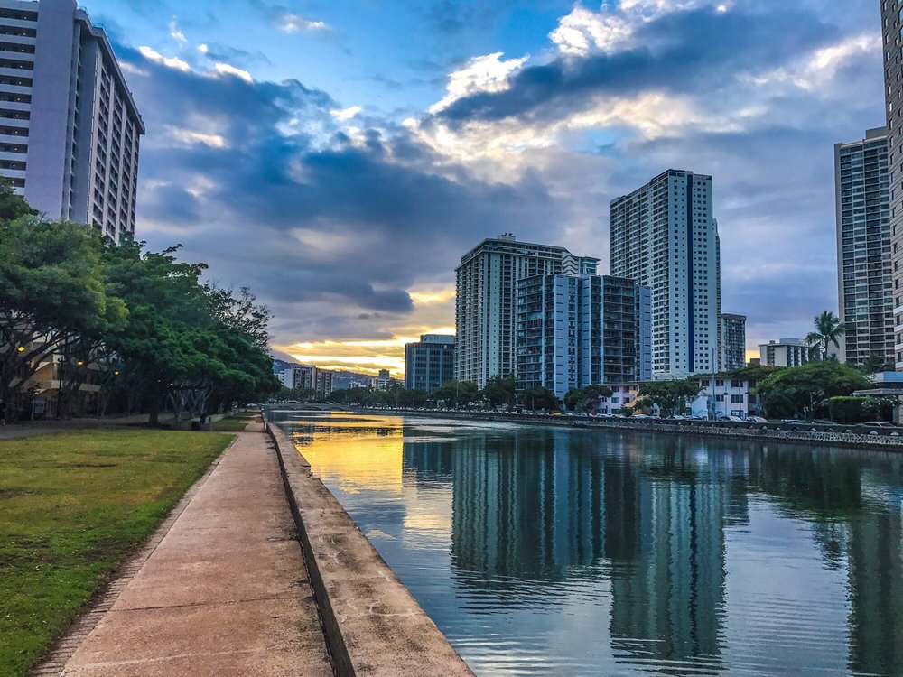
The western outlet of the canal forms Ala Wai Harbor, Honolulu's largest yacht docks.


(Photo by Dick Ebert on Encircle Photos)

Wikipedia tells us the originally planned eastern outlet was not built as currents would send outflushing sediments and contaminants onto Waikiki's beaches. There remains fear of the increasing urban pollution within the canal and of the increasing threat of urban area flooding with rising sea levels and storm strikes.


With the build up of modern Waikiki, the canal is today lined by the scenic Ala Wai Promenade.
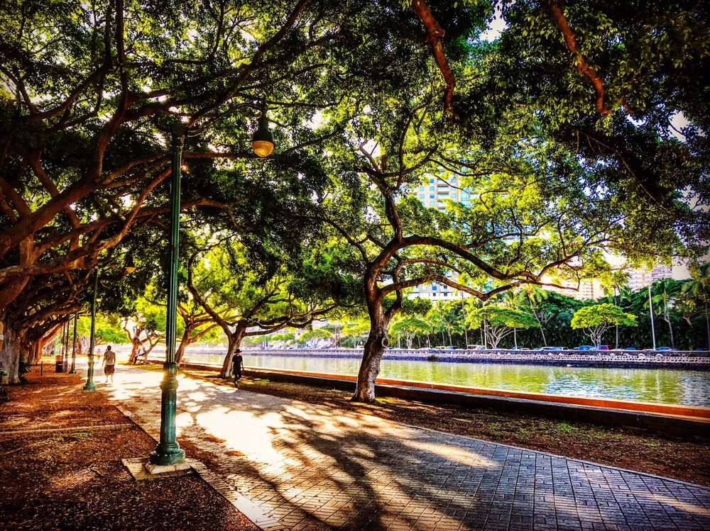

(Photo by Joe C. on Yelp)


(Photo by Joe C. on Yelp)


(Photo by Charles Madden hosted on Pinterest)

Here is a pretty drone flyover by Zoyx on YouTube.
Reply With Quote
     
     
  #52  
Old Posted Dec 3, 2018, 4:28 PM
Baronvonellis Baronvonellis is offline
Registered User
 
Join Date: Sep 2009
Location: Chicago
Posts: 880
Cape Coral, FL has the most miles of canals of any city in the world and it's where I grew up. But none of them are particularly scenic, and all of them are on private property, so there's not a single riverwalk there that I know of. It's pretty much the most anti-urban city I've ever been to. For a city of almost 200,000 the "downtown" is a couple streets with some crappy strip malls. And vacant lots that have never been built on since the swamp was drained. So, I couldn't wait to move anywhere else. Although the city has boomed with people moving there since the 50's, so the people that move there don't seem to care at all about urban settings.

The majority of tract housing in the city has a canal in their backyard, so none of the canals are urban and you have to walk into someones backyard in order to see them. You can live in the middle of the city and have a boat dock in your backyard with access to the Gulf of Mexico.

Fun fact, a couple years ago, one guy in a pickup truck fleeing from the cops tried to jump one of the canals through someones backyard. He wound up landing in the middle of the canal sinking his truck and getting arrested lol
Reply With Quote
     
     
End
 
 
Reply

Go Back   SkyscraperPage Forum > Discussion Forums > Transportation
Forum Jump


Forum Jump


All times are GMT. The time now is 10:48 AM.

     
SkyscraperPage.com - Archive - Privacy Statement - Top

Powered by vBulletin® Version 3.8.7
Copyright ©2000 - 2024, vBulletin Solutions, Inc.