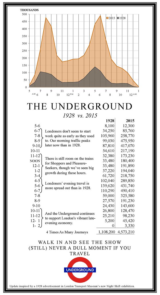
| |
 Posted Jun 11, 2018, 9:38 AM
|
|
Registered User
|
|
Join Date: Mar 2004
Posts: 2,857
|
|
Crossrail – Urban Realm Improvements
Maidenhead
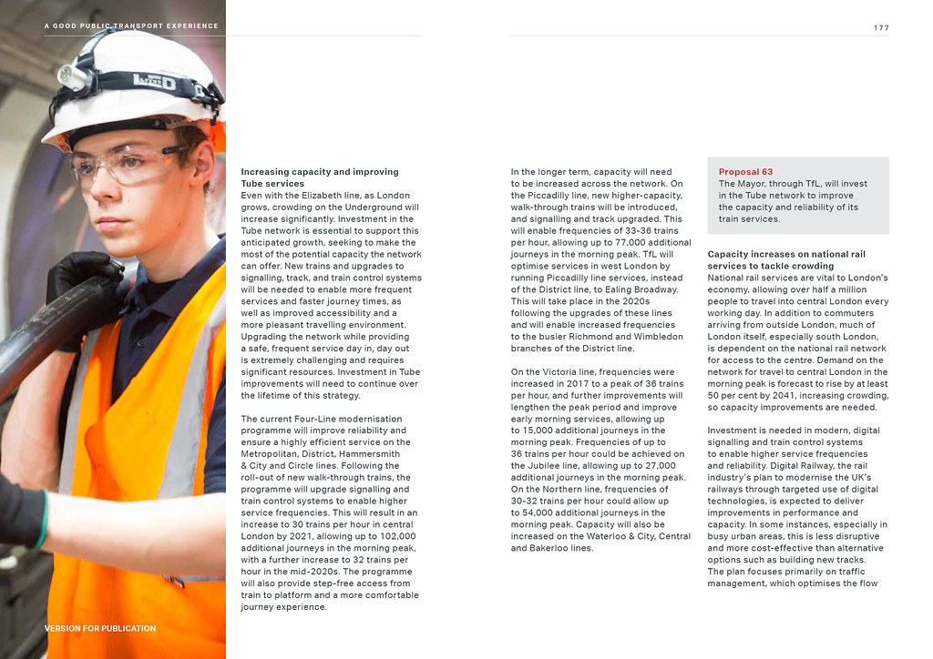
Maidenhead railway station is a major gateway to the town with around 3.5 million people passing through it each year. The Royal Borough of Windsor and Maidenhead (RBWM) has identified the station and environs as an ‘opportunity area’ to help focus regeneration and development. It has prioritised the delivery of a new transport hub at the railway station.
Crossrail and RBWM have developed a set of urban realm proposals for the immediate station area that acknowledge the ambition to create a strong physical connection between the station and the town centre. The main proposals include the creation of a new landscaped plaza to the front of the station to help provide a positive experience for passengers arriving in Maidenhead by rail.
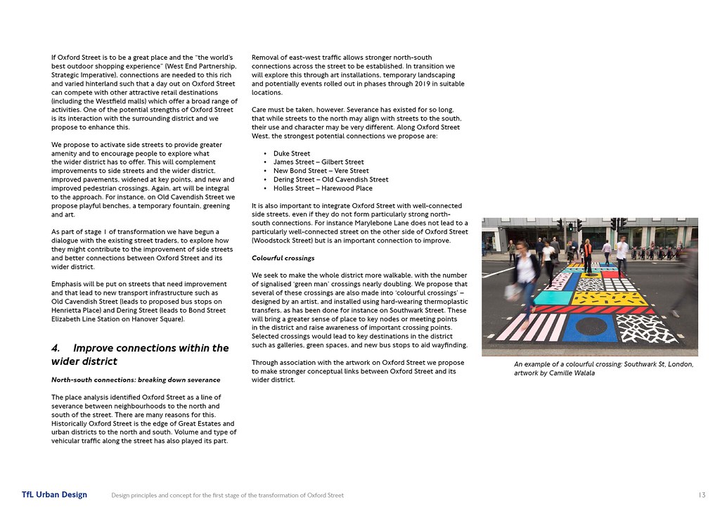
The King Street and Queen Street junction layout is reconfigured to create a vastly improved pedestrian experience and improve connectivity between the station and town centre with little impact on traffic flows.

 Image taken by Crossrail: http://www.crossrail.co.uk/route/pro...outside-london
Slough
In recent years the southern forecourt to the Grade II listed station has been improved. In contrast, the northern forecourt is somewhat neglected and is poorly utilised as a public space and arrival point to the town. Most of the space is given over to car parking and the forecourt surfaces are of poor quality with little footway space.
Image taken by Crossrail: http://www.crossrail.co.uk/route/pro...outside-london
Slough
In recent years the southern forecourt to the Grade II listed station has been improved. In contrast, the northern forecourt is somewhat neglected and is poorly utilised as a public space and arrival point to the town. Most of the space is given over to car parking and the forecourt surfaces are of poor quality with little footway space.
The arrival of Crossrail at Slough will support the borough’s ambitious Heart of Slough regeneration project that includes a striking new bus station, cultural facilities and office developments as well as major new highway and streetscape improvements.
The scheme will create a simple and adaptable pedestrian-friendly place and a suitable setting for the listed station building. The existing carriageway surfaces will be designed to be shared by vehicles, cyclists and pedestrians in a safe and low speed environment and facilities for a taxi pick-up and drop-off point, disabled parking and bus services will also be included.

 Image taken by Crossrail: http://www.crossrail.co.uk/route/pro...outside-london
Brentwood
The limited proportions of the forecourt at Brentwood station’s main entrance, coupled with a number of inactive boundaries create a stark environment. The positioning of a bus interchange directly to the north of the station entrance further restricts the adjoining pedestrian environment. A secondary entrance is located on Alexander Road, next to the station’s car park.
Image taken by Crossrail: http://www.crossrail.co.uk/route/pro...outside-london
Brentwood
The limited proportions of the forecourt at Brentwood station’s main entrance, coupled with a number of inactive boundaries create a stark environment. The positioning of a bus interchange directly to the north of the station entrance further restricts the adjoining pedestrian environment. A secondary entrance is located on Alexander Road, next to the station’s car park.
The urban realm proposal will provide a transformative change through a combination of small and medium sized improvements. One of the most crucial will see the existing bus interchange partially relocated to Alexandra Road, close to the station’s secondary entrance.
By reducing the scale of the bus stop outside the station’s main entrance, the size of the forecourt and width of the footway to the north can be increased. This in turn will allow for secure cycle parking to be introduced into the forecourt area. The existing pelican crossing on Kings Road will be moved slightly to the north in order to reflect pedestrian ‘desire lines’ towards the station’s car park.
Shenfield
Shenfield is at the eastern end of the Crossrail route and an interchange with connecting rail services to the east of England.
The station’s forecourt is located on the south side of Hutton Road, and is arranged around a taxi rank and an informal pick-up and drop-off point. The area is dominated by vehicles and is not an easy environment for station users. There is currently only one bus stop on either side of Hutton Road to serve both normal and rail replacement bus services.
Central to the design proposals is the creation of a new piazza directly in front of the station entrance. The taxi and pick-up and drop-off point will be relocated and bus stops on Hutton Road will be lengthened to cope with the forecasted increase in passenger use. From the new piazza a raised table extending across Hutton Road will calm traffic and enhance pedestrian movement. Excess street clutter is removed along Hutton Road and new trees are proposed along both footways to soften the pedestrian environment.


 Image taken by Crossrail: http://www.crossrail.co.uk/route/pro...outside-london
Harold Wood
Harold Wood is a green and leafy suburb of Romford, with a cluster of shops located along Station Road. The station’s main entrance is located on Gubbins Lane, to the south of its junction with Station Road.
Image taken by Crossrail: http://www.crossrail.co.uk/route/pro...outside-london
Harold Wood
Harold Wood is a green and leafy suburb of Romford, with a cluster of shops located along Station Road. The station’s main entrance is located on Gubbins Lane, to the south of its junction with Station Road.
While the Gubbins Lane/Station Road junction caters well for road users and there is a functional transport interchange, it is not easy for pedestrians to use when moving from the north and west. The urban realm designs propose additional crossing points at both junctions to reflect pedestrian ‘desire lines’.
The space around Harold Wood station’s secondary entrance, on the edge of the station’s car park, is dominated by vehicles and feels isolated from its surroundings. The new design removes vehicles from the area directly adjacent to the secondary entrance. A new raised forecourt will be formed solely for the usage of pedestrians and cyclists. Visual and physical connections to Station Road are vastly improved with a new seven metre wide flight of stairs and a ramp giving mobility access. Within the forecourt there is provision for public seating and secure cycle parking.
Aesthetic improvements around the station will create a bold, open and welcoming arrival point for those coming to Harold Wood.


 Image taken by Crossrail: http://www.crossrail.co.uk/route/pro...gh-of-havering
Gidea Park
The London Borough of Havering has implemented a station forecourt improvement scheme which has alleviated problems such as pinch points at Gidea Park.
Image taken by Crossrail: http://www.crossrail.co.uk/route/pro...gh-of-havering
Gidea Park
The London Borough of Havering has implemented a station forecourt improvement scheme which has alleviated problems such as pinch points at Gidea Park.
The area to the north of the station, including pedestrian access through the car park, has not been improved. A pedestrian alleyway connecting to the main residential estates is currently in a poor state of repair and feels unsafe, especially at night time. Altogether the impression is of an incomplete urban realm.
The design proposal aims to complete the urban realm around the southern entrance, and enhance access to the conservation area from the north.
On the south side, the scheme will extend the local authority’s treatment along Station Road by creating a new landscaped area with seating, introducing ‘Legible London’ signage, adding cycle parking and planting new trees. The scheme also features the resurfacing of the alleyway and the introduction of CCTV to improve safety and the replacement of the current pick-up and drop-off points with a new taxi rank.
On the north side, the car park will be redesigned to improve the urban realm by including new trees, hedges and fences, all upgraded in keeping with the conservation area.


 Image taken by Crossrail: http://www.crossrail.co.uk/route/pro...gh-of-havering
Romford
In recent years significant improvements along South Street, Romford’s main shopping street, have enhanced a vibrant metropolitan town centre. However, the area immediately around the station suffers from insufficient and poor quality pedestrian space.
Image taken by Crossrail: http://www.crossrail.co.uk/route/pro...gh-of-havering
Romford
In recent years significant improvements along South Street, Romford’s main shopping street, have enhanced a vibrant metropolitan town centre. However, the area immediately around the station suffers from insufficient and poor quality pedestrian space.
The urban design proposal will address the issues around the station area and further south along South Street.
The Battis, the street immediately outside the new northern Crossrail station entrance, is currently used for parking and delivery traffic. The proposal is to turn it into a proper pedestrian space. To the south of the station, space which is currently used for standing buses will be given widened footways. The bus stands will be relocated to Atlanta Boulevard and to assist passengers there will be a better arrangement of bus stops to provide an improved interchange.
Throughout the improvement area, there will be a comprehensive palette of street furniture, paving and lighting. This will ensure a modern high-quality experience which is step-free and safe by day and by night.
The London Borough of Havering is already working with designers Studio Weave to develop improvements for Victoria Road and The Battis.


 Image taken by Crossrail: http://www.crossrail.co.uk/route/pro...gh-of-havering
Ilford
Ilford is an important metropolitan centre and a key transport interchange in east London, served by a number of bus routes comparable to Oxford Street. The area immediately around the station suffers from insufficient and poor quality pedestrian space, with narrow footways, street clutter and high levels of congestion.
Image taken by Crossrail: http://www.crossrail.co.uk/route/pro...gh-of-havering
Ilford
Ilford is an important metropolitan centre and a key transport interchange in east London, served by a number of bus routes comparable to Oxford Street. The area immediately around the station suffers from insufficient and poor quality pedestrian space, with narrow footways, street clutter and high levels of congestion.
The urban realm scheme will provide a high-quality, generous station forecourt and an improved transport interchange, a widened and realigned main crossing outside the station on Cranbrook Road for greater pedestrian convenience and a more efficient layout of bus stops. The orientation of the new bus shelters together with wider footways will help to reduce congestion for pedestrians and queuing for passengers.
Improvements are also proposed to the secondary station entrance in York Road, which currently suffers from a lack of legibility and street presence. These will include better accessibility and safety of the area, new street furniture, improved paving and new lighting.
London Borough of Redbridge is already raising funds to deliver this ambitious scheme which aims to create a strong sense of arrival and a new focal point for Ilford.
 Image taken by Crossrail: http://www.crossrail.co.uk/route/pro...h-of-redbridge
Seven Kings
Seven Kings is one of Ilford’s key local centres that has developed around the route of the ancient Roman road between London and Colchester, also known as the High Road. The railway station sits beside a large highway intersection, where the High Road crosses the railway line, which dominates the town centre. As a consequence the traffic weakens the character of the local area to the detriment of pedestrians. But the area feels vibrant with plenty of street life and significant potential for improvement.
Image taken by Crossrail: http://www.crossrail.co.uk/route/pro...h-of-redbridge
Seven Kings
Seven Kings is one of Ilford’s key local centres that has developed around the route of the ancient Roman road between London and Colchester, also known as the High Road. The railway station sits beside a large highway intersection, where the High Road crosses the railway line, which dominates the town centre. As a consequence the traffic weakens the character of the local area to the detriment of pedestrians. But the area feels vibrant with plenty of street life and significant potential for improvement.
The arrival of Crossrail will undoubtedly result in a change in the perception of Seven Kings as it becomes a more accessible place to live with faster and more direct rail connections.
The design approach aims to improve both the station and wider High Street environment by raising the quality, design and legibility of the urban realm, addressing some of the obvious imbalances between vehicles and people.
Modifications to the High Road and Cameron Road junction layout are proposed to prioritise pedestrian movement and access to the station. This will create a more welcoming arrival space to Seven Kings. A new landscaped area is proposed on Cameron Road to help address the lack of public space and increase opportunities for meeting people as well as to provide somewhere to pause and relax away from the hustle and bustle of the main commercial area.


 Image taken by Crossrail: http://www.crossrail.co.uk/route/pro...h-of-redbridge
Goodmayes
The position of Goodmayes station, on a bridge over the railway set back from Goodmayes Road, means that it is not clearly visible from its northern and southern approaches. The forecourt is constrained with narrow footways, which are heavily used in peak periods, and unsightly parking taking space which could be better utilised by pedestrians.
Image taken by Crossrail: http://www.crossrail.co.uk/route/pro...h-of-redbridge
Goodmayes
The position of Goodmayes station, on a bridge over the railway set back from Goodmayes Road, means that it is not clearly visible from its northern and southern approaches. The forecourt is constrained with narrow footways, which are heavily used in peak periods, and unsightly parking taking space which could be better utilised by pedestrians.
Crossrail has worked with the London Borough of Redbridge to develop a design concept that rearranges the core station urban realm immediately outside the station to create an enlarged forecourt and arrival space with widened and resurfaced footways, new cycle parking, station seating and ‘Legible London’ signage to improve wayfinding and station visibility.
Wider area proposals along the main Goodmayes Road corridor include the creation of a new public space beside a local retail parade, new tree planting to soften the street and provide character and junction treatments to side road that improve accessibility and give pedestrians priority.

 Image taken by Crossrail: http://www.crossrail.co.uk/route/pro...h-of-redbridge
Chadwell Heath
Crossrail has worked with two boroughs (Barking & Dagenham and Redbridge) to design urban realm improvements for Chadwell Heath station and the surrounding area. The station building itself is located in the borough of Redbridge about 400m from the High Road, which is the local shopping centre. Many of the surrounding streets, however, are within the borough of Barking & Dagenham.
Image taken by Crossrail: http://www.crossrail.co.uk/route/pro...h-of-redbridge
Chadwell Heath
Crossrail has worked with two boroughs (Barking & Dagenham and Redbridge) to design urban realm improvements for Chadwell Heath station and the surrounding area. The station building itself is located in the borough of Redbridge about 400m from the High Road, which is the local shopping centre. Many of the surrounding streets, however, are within the borough of Barking & Dagenham.
The key concept behind the design is the creation of a continuous pedestrian link stretching from the residential areas in the south to the High Road, with the station at the area’s core. There is also potential for improvement to the space around the station.
The design proposals include footway widening and resurfacing, major junction improvements, an enhanced bus interchange and a new zebra crossing located directly outside the station. A number of additional facilities will be located in the adjacent station car park including a car pick-up and drop-off point linked to the station by a new staircase. The use of robust and consistent materials and additional street trees will complete the scheme.
The local centre on the High Road has seen recent highway improvements implemented by both local authorities. Some of the elements of the new urban realm scheme have already been delivered by Barking & Dagenham on the High Road.


 Image taken by Crossrail: http://www.crossrail.co.uk/route/pro...h-of-redbridge
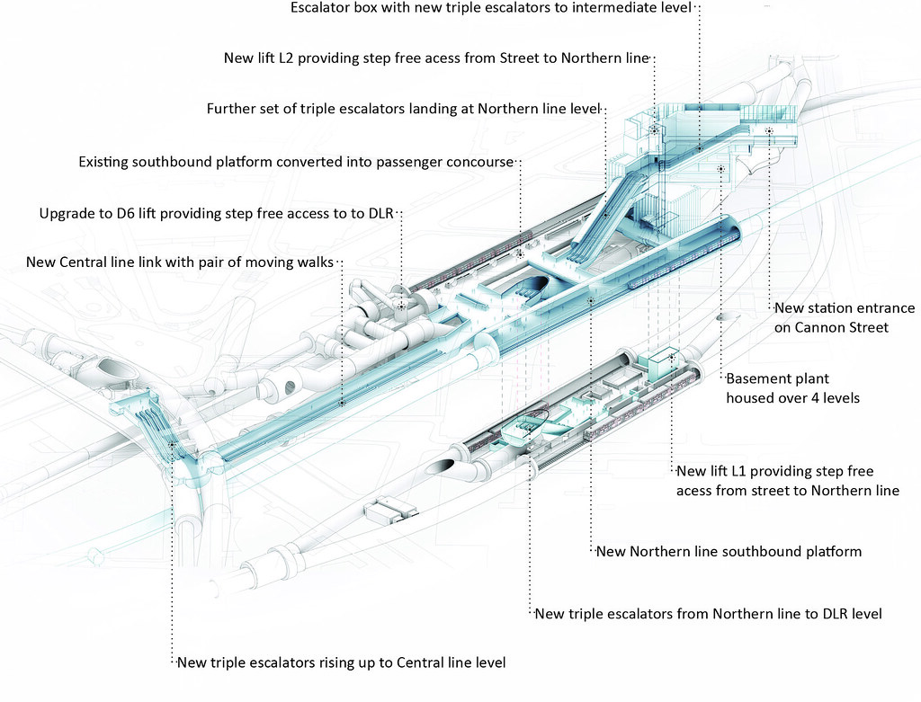
Woolwich
The new Crossrail station at Woolwich is located in the historic area of the Royal Arsenal.
Image taken by Crossrail: http://www.crossrail.co.uk/route/pro...h-of-redbridge
Woolwich
The new Crossrail station at Woolwich is located in the historic area of the Royal Arsenal.
The key challenge for the urban realm design is to integrate the new Crossrail infrastructure within the wider Woolwich Town Centre context, extending the recent public realm improvements of Beresford Market and General Gordon Square, while respecting the heritage context of the Royal Arsenal.
The scheme will connect the station to the green space of Dial Arch Square, the Royal Arsenal and the town centre to give an inviting, user-friendly and spacious environment for pedestrians.
The urban realm proposal connects the station to the green space, the Royal Arsenal and the town centre with a wide pedestrian ‘super-crossing’ on Plumstead Road. A spacious and inviting space for pedestrians will be established along the generous station forecourt running the length of the eastern side of the square. This step-free public area will be composed of high-quality natural stone and clear and logical pedestrian routes will connect pedestrians to Woolwich Town Centre.
To complement this, a paved threshold to the forecourt will merge into the green space where there will be new seating, furniture, signage and new trees planted for users to enjoy. This threshold will also respond to site levels and Verbruggens House, a grade II listed building, formin

 Image taken by Crossrail: http://www.crossrail.co.uk/route/pro...h-of-greenwich
Manor Park
Manor Park station is characterised by its proximity to the park itself on one side and the bustling life of Romford Road on the other. The surrounding urban environment is in a poor state of repair, with uneven surfaces, tired street furniture and a lack of a coherent treatment. The road outside the station is excessively wide and the retail outlets in the area are generally of a low quality. There is scope to improve connections to and from the station, introduce some trees and planting to soften what is currently a very hard urban setting and potential to extend the improvements up to the Romford Road junction.
Image taken by Crossrail: http://www.crossrail.co.uk/route/pro...h-of-greenwich
Manor Park
Manor Park station is characterised by its proximity to the park itself on one side and the bustling life of Romford Road on the other. The surrounding urban environment is in a poor state of repair, with uneven surfaces, tired street furniture and a lack of a coherent treatment. The road outside the station is excessively wide and the retail outlets in the area are generally of a low quality. There is scope to improve connections to and from the station, introduce some trees and planting to soften what is currently a very hard urban setting and potential to extend the improvements up to the Romford Road junction.
The urban realm design aims to clean up and simplify the streetscape with high-quality materials.
The proposals are for Station Road to benefit from a granite setts surface treatment fronting the station, traffic calming elements to be introduced and a new zebra crossing added.
The design will enhance the physical quality and appearance of the station forecourt and approach with new, robust materials that create a consistent pedestrian route between the stations and key destinations in the area. The interchange will be improved with wider footways at the bus stops and additional bus standing space, cycle parking closer to the station entrance and a cycle hub on a vacant plot of land opposite the station.
 Image taken by Crossrail: http://www.crossrail.co.uk/route/pro...ough-of-newham
Forest Gate
Forest Gate is fast becoming one of Newham’s most vibrant district centres and the arrival of Crossrail will improve its transport connectivity. Currently, with the station located next to a very large and complex junction, the area and the local centre feel dominated by busy road traffic. An excessive amount of railings, bollards and street furniture contribute to the clutter in the urban realm and create a series of divided spaces, one of which is being used as a local market.
Image taken by Crossrail: http://www.crossrail.co.uk/route/pro...ough-of-newham
Forest Gate
Forest Gate is fast becoming one of Newham’s most vibrant district centres and the arrival of Crossrail will improve its transport connectivity. Currently, with the station located next to a very large and complex junction, the area and the local centre feel dominated by busy road traffic. An excessive amount of railings, bollards and street furniture contribute to the clutter in the urban realm and create a series of divided spaces, one of which is being used as a local market.
The design proposes improvements which address these imbalances and unify the spaces into a coherent area.
The station entrance plaza on Woodgrange Road will be enhanced by improving pedestrian access at the junction with Forest Lane and Sebert Road by widening the footway. At the main junction the left turn on to Forest Lane will be removed, providing extra space for people to walk to the station. The carriageway will be resurfaced in granite setts and wider crossings will encourage traffic calming and ease of use by pedestrians.
The scheme also aims to create a new public transport hub by connecting all modes of transport, improving interchange and rationalising bus stop locations. Convenient cycle parking will be provided by spaces on Woodgrange Road and a secure cycle hub just off Woodgrange Road. There will be a taxi stand for pick-up and drop-off.
 Image taken by Crossrail: http://www.crossrail.co.uk/route/pro...ough-of-newham
Maryland
The area around Maryland station is dominated by the road network, including a large roundabout the design of which has little consideration of, or facilities for, pedestrians and cyclists. Most notably, there is an array of barriers and railings between the carriageway and the footways giving rise to a segregated and hostile pedestrian environment. The footway outside the station is very narrow and gives a constricted pedestrian access on approach to Maryland station.
Image taken by Crossrail: http://www.crossrail.co.uk/route/pro...ough-of-newham
Maryland
The area around Maryland station is dominated by the road network, including a large roundabout the design of which has little consideration of, or facilities for, pedestrians and cyclists. Most notably, there is an array of barriers and railings between the carriageway and the footways giving rise to a segregated and hostile pedestrian environment. The footway outside the station is very narrow and gives a constricted pedestrian access on approach to Maryland station.
The urban realm design scheme aims to give the area a new identity and create a focal point by forming a new station entrance plaza on Leytonstone Road, and effectively reshaping the highway.
The scheme will provide a significantly improved pedestrian access with widened footway and a reduction in the dominance of vehicles in the area. New paving will calm traffic with granite setts applied to all crossing points and to the section of the highway that links the two main public spaces. The removal of the existing roundabout will improve the transport interchange. Also proposed is new cycle parking, a taxi stand, pick-up and drop-off point, and wayfinding integrated with a public transport interchange along routes to and from Maryland station. Tree planting will also soften the urban landscape.
 Image taken by Crossrail: http://www.crossrail.co.uk/route/pro...ough-of-newham
Whitechapel
The challenge for the urban realm design is to make the station entrance a distinctive landmark, amid the bustle of Whitechapel Road market, and to create sufficient space for pedestrians entering and leaving the station and crossing to the Royal London Hospital on the south side of Whitechapel Road.
Image taken by Crossrail: http://www.crossrail.co.uk/route/pro...ough-of-newham
Whitechapel
The challenge for the urban realm design is to make the station entrance a distinctive landmark, amid the bustle of Whitechapel Road market, and to create sufficient space for pedestrians entering and leaving the station and crossing to the Royal London Hospital on the south side of Whitechapel Road.
The new entrance to the Crossrail station will be in the same location as the existing entrance on Whitechapel Road; during construction work there will be a temporary ticket office in Court Street.
The first improvements for the area will be at Court Street where the temporary entrance to the station opens later this year. The street will be pedestrianised, the current carriageway raised to create a unified surface and the existing railway bridge canopy removed to create a safer, more pedestrian-friendly route.
On Whitechapel Road, to accommodate the permanent entrance to the station, improvements will rationalise and increase the size of the station’s forecourt. In addition the use of feature paving will give the forecourt a stronger definition.
Durward Street is a less active space than Whitechapel Road and before Crossrail construction works began occupying the site, it was used mostly for vehicle parking and as a bus stand. The hard surfaces and blank frontages made it an intimidating space for pedestrians. The scheme aims to reduce the car parking, remove the bus stand and enable the public space to respond to pedestrian ‘desire lines’, creating a greener more inviting environment.


 Image taken by Crossrail: http://www.crossrail.co.uk/route/pro...-tower-hamlets
Liverpool Street - West (Moorgate)
The new station entrance at Moorgate will not only lead to a new, spacious and fully integrated ticket hall, but will also improve the passenger experience of the external public realm.
Image taken by Crossrail: http://www.crossrail.co.uk/route/pro...-tower-hamlets
Liverpool Street - West (Moorgate)
The new station entrance at Moorgate will not only lead to a new, spacious and fully integrated ticket hall, but will also improve the passenger experience of the external public realm.
As part of the Crossrail works, significant areas of land have been used to facilitate the construction of the new station and associated railway infrastructure. The site restoration scheme for the Moorgate station entrance is based on proposals developed in consultation with the City of London, TfL, London Underground and other local stakeholders including Land Securities and Aviva Investors.
The public realm proposals follow the City of London’s street design guidance and have taken account of the City’s Moorgate Crossrail Station Urban Integration proposals, as approved in February 2015. Options for the wider area are currently being developed by the City and will be the subject of further stakeholder engagement.
Crossrail’s public realm proposals recognise the City of London’s ambition to create a coherent, civic place that will transform the Moorgate and Moorfields area from a space previously laid out as a conventional highway with mixed and sometimes unclear priorities, to one with greater pedestrian priority, and ease of interchange between different rail services.
In Moorgate and Moorfields the public realm improvements will include:
- Reducing carriageway width in Moorgate and increasing footway space.
- Introduction of a central pedestrian median in Moorgate to improve crossing at a key pedestrian crossing point and improve accessibility for all users.
- A new pedestrianised public space will be created on Moorfields between New Union Street and London Wall, with access limited to emergency and service vehicles only.
- Moorfields south of Moor Place will act as a ‘secure zone’ outside the new station entrance in which vehicles access will be controlled via station controlled retractable bollards.
- Pavements and carriageways will be treated with a combination of high quality Yorkstone and granite changing Moorfields into a pedestrian friendly space, dispersed interchange and station forecourt.
- New way-finding signage will help visitors to orientate themselves and direct them to surrounding areas and key destinations of the City.
- The proposals have been designed to tie in with the wider public realm improvements being progressed by the City of London, to be further consulted on and agreed through the City’s standard consultation Committee processes.
- Away from the raised carriageway areas regular kerb heights are retained in close proximity to the station entrance in Moorfields, Moorgate and Fore Street which allow for comfortable boarding of taxis via wheel chair ramps. The closest regular height kerbs to the station are located approximately 30m from the station entrance on Moorfields and Moorgate.
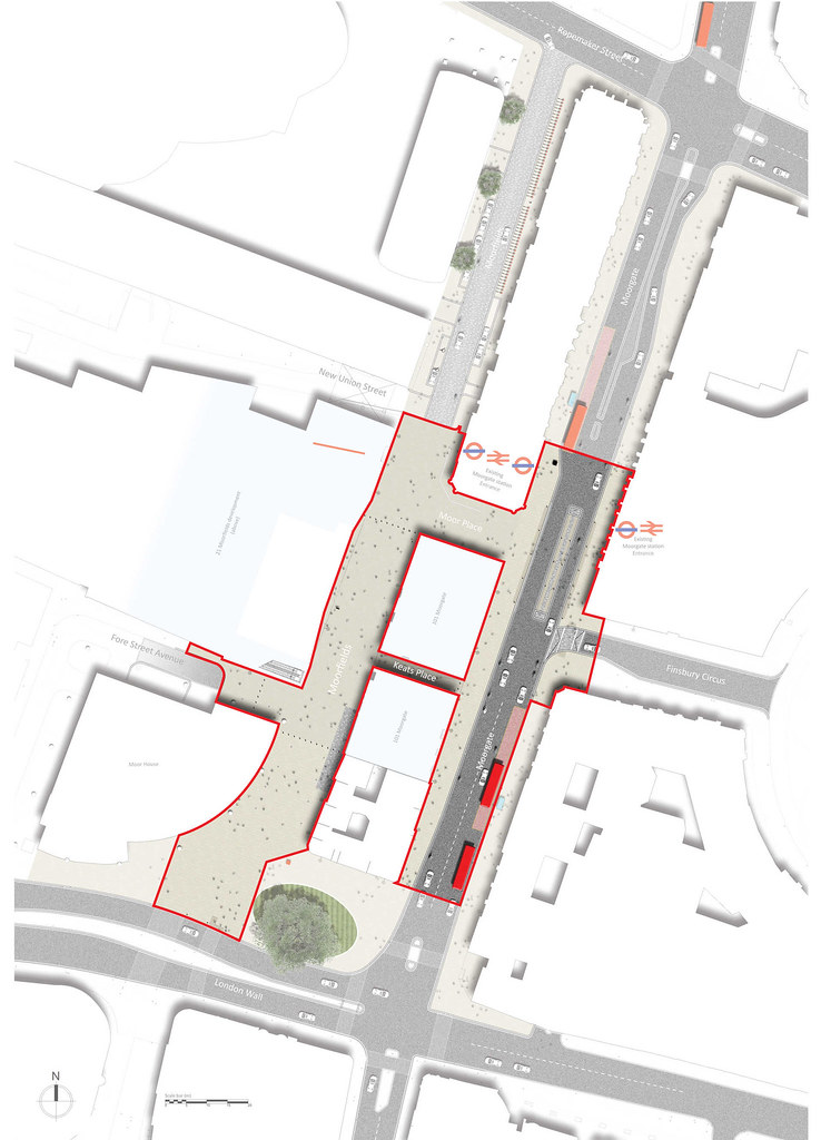

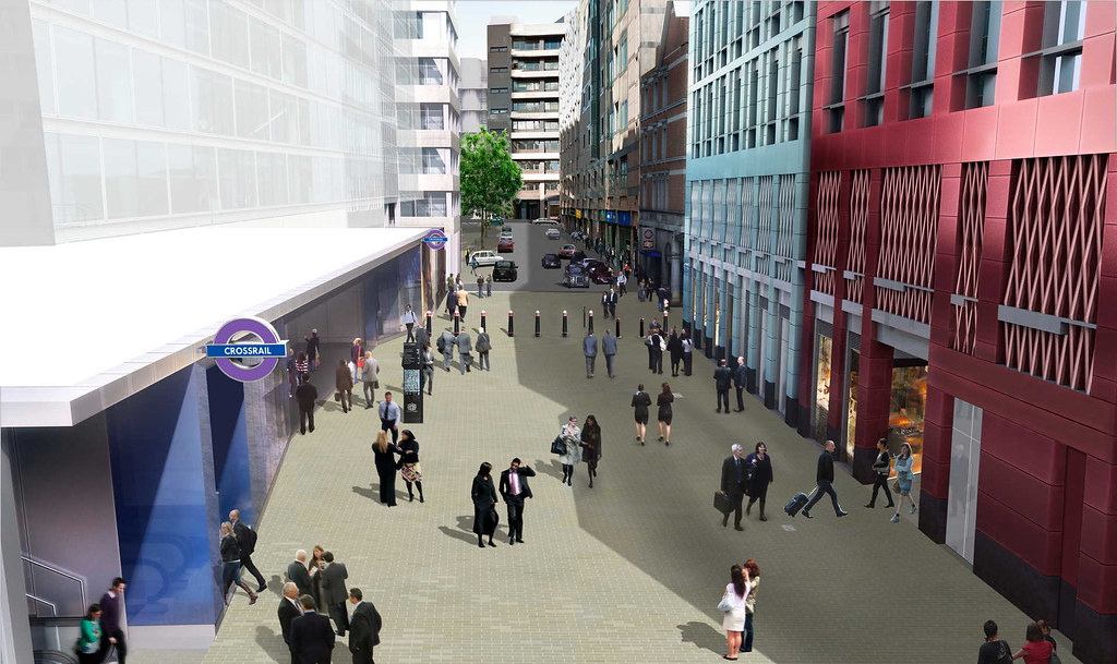
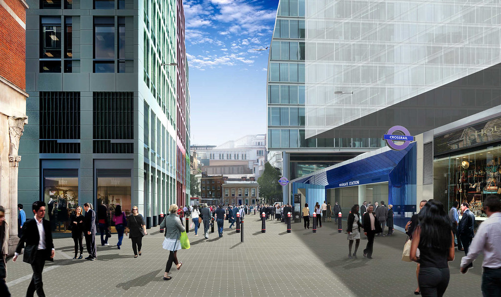 Image taken by Crossrail: http://www.crossrail.co.uk/route/pro...city-of-london
Liverpool Street - East
The aim of the urban realm design is to create a safe and welcoming public space that functions as a gateway to the City of London.
Image taken by Crossrail: http://www.crossrail.co.uk/route/pro...city-of-london
Liverpool Street - East
The aim of the urban realm design is to create a safe and welcoming public space that functions as a gateway to the City of London.
The station is a destination for tens of thousands of people who use it every day on their way to work, as visitors to the City or the nearby areas of Spitalfields and Shoreditch. The area around the station has to deal with large numbers of servicing vehicles, taxis and buses. The arrival of Crossrail will see significant increases in pedestrian movements and modes of transport getting to and from the station.
The new public space on Liverpool Street will facilitate the free and easy movement of people, create conditions for waiting and simply enjoying the space, and allow the necessary vehicle access without spoiling the pedestrian experience.
The key proposal is to restrict road traffic in Liverpool Street between Old Broad Street and Blomfield Street, and create a consistent surface across the area using a palette of traditional materials in keeping with the prevailing City of London character. New seats will be introduced and all the principal pedestrian ‘desire lines’ across vehicle routes will be raised flush to increase pedestrian priority and improve accessibility.


 Image taken by Crossrail: http://www.crossrail.co.uk/route/pro...city-of-london
Farringdon - West (Cowcross Street)
The urban realm scheme was developed to cope with the predicted increase in passenger flow once Crossrail arrives. The scheme maximises pedestrian capacity in the peak periods, while providing an attractive new public space outside of the peak.
Image taken by Crossrail: http://www.crossrail.co.uk/route/pro...city-of-london
Farringdon - West (Cowcross Street)
The urban realm scheme was developed to cope with the predicted increase in passenger flow once Crossrail arrives. The scheme maximises pedestrian capacity in the peak periods, while providing an attractive new public space outside of the peak.
Crossrail passengers will enter and exit the station via the new ticket hall, which opened in 2011, in Cowcross Street, opposite the Metropolitan line London Underground station. The scheme includes creating a pedestrianised space in Cowcross Street and strips out all street furniture other than a narrow central furniture and tree planting zone. A sense of continuity between the two station entrances is achieved by utilising materials that reflect the colour scheme of the station ticket hall flooring.
At the western end of Cowcross Street, the pedestrian crossing over Farringdon Road will be raised to provide step-free access and ‘feature lighting’ columns will help landmark the station from along Farringdon Road.
The proposed property development on the corner of Cowcross Street and Farringdon Road will provide an active frontage with the potential for outdoor tables and chairs to help enhance the space outside of peak hours.
Part of the design is already constructed at the eastern end of Cowcross Street; pedestrians benefit from a raised table, wider footways, improved materials and new tree planting. Overall the scheme will deliver a high-capacity gateway and an attractive new public space for people travelling, visiting, living and working in and around Farringdon.


 Image taken by Crossrail: http://www.crossrail.co.uk/route/pro...h-of-islington
Farringdon - East
The urban realm scheme at Farringdon East will lead passengers to a new station entrance located at the corner of Long Lane and Lindsey Street, in the block immediately to the east of Smithfield Market. The market and the adjacent Charterhouse Square denote this as an area of historical significance.
Image taken by Crossrail: http://www.crossrail.co.uk/route/pro...h-of-islington
Farringdon - East
The urban realm scheme at Farringdon East will lead passengers to a new station entrance located at the corner of Long Lane and Lindsey Street, in the block immediately to the east of Smithfield Market. The market and the adjacent Charterhouse Square denote this as an area of historical significance.
The existing urban realm is inconsistent in its treatment and quality, with a limited number of formal pedestrian crossings and poor way-finding. The area operates in very different ways depending upon the time of day. It can be dominated by HGV vehicles servicing the market in the very early hours of the morning, by commuters during the day and by a very active night-time economy in the evenings. As such, the new urban realm scheme has been designed to function effectively for each of these users.
The urban realm proposals include the following improvements:
- Large raised pedestrian tables designed to calm traffic and prioritise pedestrian movements both outside the station entrance on Long Lane and at the junction of Charterhouse Street and Lindsey Street.
- A secure line of bollards, way-finding signage and belisha beacons will protect the station entrance on Long Lane.
- Widened footways combined with enlarged and relocated pedestrian crossings, to reflect pedestrian needs, will improve the experience of moving through the area.
- High-quality materials, such as Yorkstone paving for the footways, will be used to integrate the scheme with the local environment, such as the historic Smithfield Market.
- Hayne Street will be a single surface, with Yorkstone footway and granite kerbs laid flush to the granite carriageway, creating a seamless shared surface for pedestrians and vehicles.
- Regular kerb heights are retained beyond the areas of raised table, which allows for comfortable boarding of taxis via wheel chair ramps. The closest regular height kerb to the station is located approximately 20m from the station entrance on Lindsey Street.

 Image taken by Crossrail: http://www.crossrail.co.uk/route/pro...city-of-london
Tottenham Court Road - West (Dean Street)
The focus of the urban realm scheme will be on the streets to the immediate south of Oxford Street that surround Crossrail’s Tottenham Court Road west entrance between Dean Street and Great Chapel Street.
Image taken by Crossrail: http://www.crossrail.co.uk/route/pro...city-of-london
Tottenham Court Road - West (Dean Street)
The focus of the urban realm scheme will be on the streets to the immediate south of Oxford Street that surround Crossrail’s Tottenham Court Road west entrance between Dean Street and Great Chapel Street.
Soho is one of central London’s most dynamic districts. It continues to attract workers, visitors and tourists, with its Georgian streets now home to many of the UK’s successful independent media companies and some of London’s best restaurants, bars and clubs. Crossrail’s Dean Street station entrance will become part of the first underground station in Soho.
The station entrance will open into the northern part of Dean Street, adjacent to the junction with Oxford Street and is set to increase the footfall in this area. The urban realm scheme aims to knit the new station building and the new residential development above with the existing urban fabric by using traditional materials in a contemporary design.
A generous space for pedestrians will be created by closing off a small section of Dean Street between Fareham Street and Oxford Street to vehicles. On the other streets, the existing traffic arrangements will be maintained by keeping Fareham Street open to through-traffic. It will have widened footways and provide raised carriageways to rebalance the streetscape with greater consideration to the needs of pedestrians.

 Image taken by Crossrail: http://www.crossrail.co.uk/route/pro...of-westminster
Tottenham Court Road - East
The existing Tottenham Court Road station is being rebuilt to accommodate Crossrail and the new ticket hall will be six times the size of the original. This, together with the property developments which are planned to take place on both sides of Tottenham Court Road, represents a crucial opportunity for Crossrail to act as a catalyst for transforming a part of central London.
Image taken by Crossrail: http://www.crossrail.co.uk/route/pro...of-westminster
Tottenham Court Road - East
The existing Tottenham Court Road station is being rebuilt to accommodate Crossrail and the new ticket hall will be six times the size of the original. This, together with the property developments which are planned to take place on both sides of Tottenham Court Road, represents a crucial opportunity for Crossrail to act as a catalyst for transforming a part of central London.
St Giles Circus lies at the heart of some of the capital’s most popular destinations. However, this is a part of central London previously characterised by poor public realm and a dominating gyratory traffic system. Pedestrian movement was compromised by street clutter and narrow footways which at times caused an uncomfortable and, in places, unsafe experience on foot.
Crossrail has been working on the St Giles urban realm design proposal with its partners London Underground, TfL and the two local authorities Camden and Westminster. The scheme will create a new piazza around the new glass station entrances to provide a generous pedestrian space and extend around the base of Centre Point. It will re-establish the historic links between Oxford Street and Covent Garden. A pedestrian crossing between the piazza and a new landscaped space in Sutton Row will create a direct and legible walking route between St Giles, Centre Point and Soho Square to the west.


 Image taken by Crossrail: http://www.crossrail.co.uk/route/pro...of-westminster
Bond Street - West (Davies Street)
The new urban realm scheme will sensitively integrate the new Crossrail station entrance with the surrounding environment and accommodate the increase in passenger numbers.
Image taken by Crossrail: http://www.crossrail.co.uk/route/pro...of-westminster
Bond Street - West (Davies Street)
The new urban realm scheme will sensitively integrate the new Crossrail station entrance with the surrounding environment and accommodate the increase in passenger numbers.
The Bond Street western station entrance is located on Davies Street, one of the main routes from Oxford Street to Mayfair, behind the West One shopping centre and the existing Bond Street station. This area is a busy shopping and tourist thoroughfare with high pedestrian flows.
The footfall is set to increase in the future, and as a result spaces for pedestrians and vehicles have been reviewed. Improvements will include a wide, raised crossing outside the station to address key pedestrian ‘desire lines’, while pedestrian priority areas are created to the north and south of the station on Weighhouse Street and St Anselm’s Place
At the eastern end of Weighhouse Street a prominent and generous forecourt to the station entrance will be created. The forecourt space will feature high-quality granite paving that will extend into the station concourse. St Anselm’s Place will also
be repaved.
Along Davies Street there will be a reduction of carriageway width and provision of much wider footways to accommodate the expected increase in pedestrian flows. This is complemented by a general decluttering of the area, use of high-quality materials, provision of cycle stands, ‘Legible London’ signage and improved lighting.

 Image taken by Crossrail: http://www.crossrail.co.uk/route/pro...of-westminster
Bond Street - East (Hanover Square)
The urban realm design provides a new setting for the Crossrail station and a framework for restoration of the historic layout of the square by creating generous pedestrian areas around the gardens and on all sides of the square.
Image taken by Crossrail: http://www.crossrail.co.uk/route/pro...of-westminster
Bond Street - East (Hanover Square)
The urban realm design provides a new setting for the Crossrail station and a framework for restoration of the historic layout of the square by creating generous pedestrian areas around the gardens and on all sides of the square.
The new Crossrail station entrance on Hanover Square is located in the Mayfair conservation area, between Oxford Street and Regent Street. In the past the environment in Hanover Square has been dominated by traffic, with very wide carriageways, low quality pedestrian space and the general lack of a coherent public realm.
In Tenterden Street the proposals see the creation of a shared surface treatment. This will maximise the area available to pedestrians and create a prominent and generous forecourt to the station entrance. High-quality granite paving will extend into the station concourse. Four at-grade diagonal crossing points will be introduced on Hanover Square with adjacent footways in matching materials.
Where Tenterden Street joins Hanover Square there will also be lighting, seating opportunities and ‘Legible London’ signage. Cycle parking will be provided at several locations in the square and taxi bays are relocated closer to the station. It is hoped that the additional improvements to the rest of the square included in the urban realm masterplan will be funded by third parties.
The Crossrail property development, being delivered by Great Portland Estates, includes an additional element of new urban realm: a new public courtyard space which can be accessed from Tenterden Street, New Bond Street and Brook Street.


 Image taken by Crossrail: http://www.crossrail.co.uk/route/pro...of-westminster
Paddington - Eastbourne Terrace
The urban realm design will take advantage of the relocation of the taxi facility to the opposite side of the station, and transform this area into a world-class arrival space.
Image taken by Crossrail: http://www.crossrail.co.uk/route/pro...of-westminster
Paddington - Eastbourne Terrace
The urban realm design will take advantage of the relocation of the taxi facility to the opposite side of the station, and transform this area into a world-class arrival space.
Paddington Station is a Grade I listed building with a unique architectural and transport heritage. Crossrail is set to transform the Departures Road area of the station from a taxi pick-up area which was oppressive, dark and noisy with confined and narrow pavements, into a world-class arrival space for Crossrail passengers. Eastbourne Terrace, which sits above Departures Road, is a Crossrail worksite. The road has now been partially reopened. As a bus interchange area, it has been difficult for pedestrians to move around Departures Road or the station because of the change of levels and poor legibility.
Eastbourne Terrace will be dramatically improved with a lift and three wide staircases. The scheme for the station interchange will incorporate a taxi drop-off point, cycle and motorcycle parking and a much more easily seen direct link to buses. Servicing arrangements, security measures, several benches and new trees are also fully integrated into the design.
In Departures Road the urban realm scheme replaces the taxi facility with a series of zones, created in natural stone, along the new pedestrian area to reflect the scale and direction of the street, creating threshold, movement and anchoring spaces. The design for the public space will encourage pedestrians around Paddington to visit Departures Road for shopping, eating and drinking as well as the station.


 Image taken by Crossrail: http://www.crossrail.co.uk/route/pro...of-westminster
Paddington - Canalside
The urban realm scheme, interim until the development over the station begins, supports the new station entrance which opened in 2013. It also creates a vibrant public space with soft and hard landscaping, ‘Legible London’ signage and security bollards.
Image taken by Crossrail: http://www.crossrail.co.uk/route/pro...of-westminster
Paddington - Canalside
The urban realm scheme, interim until the development over the station begins, supports the new station entrance which opened in 2013. It also creates a vibrant public space with soft and hard landscaping, ‘Legible London’ signage and security bollards.
The new entrance to the Hammersmith and City line at Paddington, together with its urban realm, was constructed by Crossrail.
This is part of a wider project known as the ‘Paddington Integrated Project’ which, in partnership with London Underground and Network Rail, saw the creation of a new taxi facility on the former Red Star Deck and the refurbishment of the fourth span of the mainline station.
The area around the western Grand Union Canal towpath was previously characterised by uneven surfaces, limited connections and lack of signage and wayfinding.
In the longer term, a permanent urban realm design scheme aims to complete the waterside public space within the Paddington Basin. It will establish a clear, safe and accessible towpath alongside the canal, station entrance and office development, which will be built over the entrance. This will aid pedestrian movements and wayfinding from station exits and surrounding developments while maintaining the character and quality of the area by respecting the historical industrial character of the Basin.
 Image taken by Crossrail: http://www.crossrail.co.uk/route/pro...of-westminster
Acton Main Line
Crossrail is building a new Acton Main Line station just to the south of the existing building on the junction of Horn Lane and Friary Road with a location and orientation that creates a new station forecourt east of the station and a new space to the rear.
Image taken by Crossrail: http://www.crossrail.co.uk/route/pro...of-westminster
Acton Main Line
Crossrail is building a new Acton Main Line station just to the south of the existing building on the junction of Horn Lane and Friary Road with a location and orientation that creates a new station forecourt east of the station and a new space to the rear.
The road junction is currently signalised, with significant guardrailing and pedestrian crossings that do not provide for natural pedestrian ‘desire lines’. Nearby footways have a number of pinch points, compounded by poorly located street furniture, and suffer from the use of multiple materials. There is no public seating close-by.
The aim of the urban realm design is to replace the existing signalised crossing with a non-standard roundabout layout using more robust materials, similar to the pioneering scheme in Poynton, Cheshire. Zebra crossings on each arm of the crossing will improve pedestrian access, while simultaneously slowing traffic and increasing junction capacity. Other features include narrowing the carriageway, footway widening, new tree planting, relocated bus-stop facilities, new public seating, and a cycle hub behind the station providing covered parking space for up to 84 bikes.


 Image taken by Crossrail: http://www.crossrail.co.uk/route/pro...ough-of-ealing
Ealing Broadway
Ealing Broadway station is the main gateway to the borough but it suffers from a poor immediate urban environment and low quality pedestrian links to the wider area. The character of the area is defined by the attractive green space of Haven Green, as well as the main thoroughfares and shopping centres of Ealing to the south.
Image taken by Crossrail: http://www.crossrail.co.uk/route/pro...ough-of-ealing
Ealing Broadway
Ealing Broadway station is the main gateway to the borough but it suffers from a poor immediate urban environment and low quality pedestrian links to the wider area. The character of the area is defined by the attractive green space of Haven Green, as well as the main thoroughfares and shopping centres of Ealing to the south.
The interchange between modes of transport at the station could be improved. Much of the station forecourt was until recently used for car parking, servicing and as pick-up and drop-off points for station users. This restricts pedestrian movement and gives a poor first impression on leaving the station.
The urban realm proposals for Ealing Broadway include a rationalisation of bus stop arrangements as a wider package of works designed to complement an improved station, minimise bus impact on Haven Green and improve the overall user experience of the area.
Within the station forecourt, work has already begun to provide (as a temporary treatment) a new space in which pedestrians have priority. The existing retaining wall will be removed at key locations to provide pedestrian routes; where it is retained, it will provide seating and the structure for a new cycle
parking area.
Further improvements will include a new bus shelter, feature lighting to announce the station’s presence, more footway space at key pinch points and the crossing between the forecourt and Haven Green which will give pedestrians greater priority.

 Image taken by Crossrail: http://www.crossrail.co.uk/route/pro...ough-of-ealing
West Ealing
Crossrail will relocate the station from its existing position on Drayton Green Road, which carries significant through-traffic, to Manor Road – a quieter side street.
Image taken by Crossrail: http://www.crossrail.co.uk/route/pro...ough-of-ealing
West Ealing
Crossrail will relocate the station from its existing position on Drayton Green Road, which carries significant through-traffic, to Manor Road – a quieter side street.
Parts of the urban realm have already been upgraded as part of recent new developments in the area and these improvements will be extended as part of the Crossrail design. The proposals include innovative lighting, a statement landmark structure and a station totem to address the location of the new station building on a side road. Other improvements include a new forecourt and a raised table across the carriageway to calm traffic and connect the forecourt with the shops and the minicab office opposite; seating for those awaiting pickup; and a cycle hub providing covered space for up to 148 bikes.
Concept proposals for the unused railway platforms running parallel to Manor Road include landscaping or potentially container architecture. To help animate the forecourt, there is space for a new ‘pop-up’ cafe with tables and chairs.
Drayton Green Road, will retain its existing function, but will be treated in coloured tarmac with a flush central refuge to calm traffic and aid pedestrian crossing. The bus stop to the north of Manor Road could be relocated to outside the existing station building if space there can be created by demolishing the redundant ticket office.


 Image taken by Crossrail: http://www.crossrail.co.uk/route/pro...ough-of-ealing
Hanwell
Hanwell station is a smaller and comparatively lightly-used station located in a predominantly residential area on a quiet street some distance away from the nearest major road. Despite the attractiveness of the Grade II listed station and the nearby houses, the streetscape generally suffers from inconsistent paving quality and a lack of step-free pedestrian crossings.
Image taken by Crossrail: http://www.crossrail.co.uk/route/pro...ough-of-ealing
Hanwell
Hanwell station is a smaller and comparatively lightly-used station located in a predominantly residential area on a quiet street some distance away from the nearest major road. Despite the attractiveness of the Grade II listed station and the nearby houses, the streetscape generally suffers from inconsistent paving quality and a lack of step-free pedestrian crossings.
The urban realm proposals seek to address this and capitalise on the attractiveness of the station building by creating an enhanced forecourt in York stone with a granite setts ‘carpet’, lit by heritage lighting columns, and reducing the parking directly in front of the station. A bench is provided in the forecourt for those awaiting pickup, along with increased cycle parking. A station totem will make the station more visible from a distance.
There are plans, promoted by the borough, to reopen the rear station entrance. The proposals to improve the space outside this entrance include: providing flexible space for drop-off and pick-up, paving to match the front entrance, cycle parking, public seating, the kerbs realigned to increase footway width, lighting enhanced to address safety concerns, and concerns over speeding traffic to be addressed by raising the carriageway.


 Image taken by Crossrail: http://www.crossrail.co.uk/route/pro...ough-of-ealing
Southall
A new Crossrail station will be built just to the north of the existing building on the South Road railway bridge. The wider Southall area is likely to change substantially in future years due to large scale redevelopment sites such as the Southall Gas Works site which has permission for 3,750 homes. There is enormous potential for improvement in the area around Southall station.
Image taken by Crossrail: http://www.crossrail.co.uk/route/pro...ough-of-ealing
Southall
A new Crossrail station will be built just to the north of the existing building on the South Road railway bridge. The wider Southall area is likely to change substantially in future years due to large scale redevelopment sites such as the Southall Gas Works site which has permission for 3,750 homes. There is enormous potential for improvement in the area around Southall station.
At present the urban landscape around the station is of a poor quality. Changes in levels, pedestrian footway widths, the location of bus infrastructure, and pedestrian facilities at nearby junctions all need improvement. The station bridge is an important road link but also needs to cater for pedestrians crossing to the station.
The proposals for the urban realm outside Southall station provide a significant new civic space for Southall. The scheme provides an enhanced transport interchange for pedestrians and cyclists, widened footways, better paving materials, and generous new pedestrian areas around the station where they are needed most. Flexible parking and loading space can be provided close to the station entrance and significant amounts of cycle parking space are also proposed. In addition, the junctions at either end of the bridge can be reconfigured to provide better pedestrian crossing facilities. Further afield, an alternative route across the tracks for pedestrians and cyclists is proposed by replacing the currently disused footbridge east of the station.


 Image taken by Crossrail: http://www.crossrail.co.uk/route/pro...ough-of-ealing
Hayes & Harlington
The existing Hayes and Harlington station building is located on the bridge over the railway tracks. A new larger Crossrail station will be built just north of the existing site. The local area is largely made up of low density, suburban housing, with the exception of the recent High Point Village residential development, the first of a number of developments set to substantially change the character of the station environs.
Image taken by Crossrail: http://www.crossrail.co.uk/route/pro...ough-of-ealing
Hayes & Harlington
The existing Hayes and Harlington station building is located on the bridge over the railway tracks. A new larger Crossrail station will be built just north of the existing site. The local area is largely made up of low density, suburban housing, with the exception of the recent High Point Village residential development, the first of a number of developments set to substantially change the character of the station environs.
Though Hayes Town Centre and the station are within easy walking distance of each other, the lack of clear visual links between the two, allied to the relatively poor quality of walking routes, means that they feel very separate from each other.
The urban realm design proposals include a number of options which ‘future proof’ the area for the large scale developments that are likely to come forward. Each option creates a new public space in the triangle site between the proposed station building and High Point Village. They improve pedestrian and cycle connectivity to the station in all directions through better pedestrian crossings, continuous cycle lanes, tree planting, higher quality materials and safer junctions. The scheme will also provide step-free accessibility between the station and the proposed major developments to the west, via a ramp from Station Road to Blyth Road, which provides a more direct route for those who are less mobile.


 Image taken by Crossrail: http://www.crossrail.co.uk/route/pro...-of-hillingdon
West Drayton
The existing welcome for station users at West Drayton is poor. Passengers need to negotiate a busy bus route along narrow footways and a space that lacks any amenities. The station is located immediately south of the Grand Union Canal, but is almost entirely cut off from the waterfront.
Image taken by Crossrail: http://www.crossrail.co.uk/route/pro...-of-hillingdon
West Drayton
The existing welcome for station users at West Drayton is poor. Passengers need to negotiate a busy bus route along narrow footways and a space that lacks any amenities. The station is located immediately south of the Grand Union Canal, but is almost entirely cut off from the waterfront.
The urban realm proposals aim to achieve a high-quality gateway experience by creating a new canal-side pocket park next to the station with tree planting, public seating and steps down to the water’s edge.
Station Approach, up to the station’s main entrance, will benefit from the introduction of continuous step-free footway on both sides, the traffic management is simplified and its visual impact is softened. A new space adjacent to the station will include a cycle hub and an enlarged and relocated bus shelter, which will leave more room for passing pedestrians.
Outside the rear entrance of West Drayton station, the scheme will create a shared surface at the vehicle turnaround point, which will make it easier to access the station building by following pedestrian ‘desire lines’. Other improvements here include an enlarged forecourt area outside of the station entrance, public seating, a small amount of cycle parking, and tree planting.


 Image taken by Crossrail: http://www.crossrail.co.uk/route/pro...-of-hillingdon
|
|
|


 Prev
Prev


 Linear Mode
