HomeDiagramsDatabaseMapsForum About
     

Go Back   SkyscraperPage Forum > Discussion Forums > Transportation


Reply

 
Thread Tools Display Modes
     
     
  #1  
Old Posted Aug 23, 2015, 9:50 PM
Pink Jazz's Avatar
Pink Jazz Pink Jazz is offline
Registered User
 
Join Date: Apr 2015
Posts: 100
Interlining bus or rail routes

For those who don't know what I am talking about, in the transit world, interlining is when a bus or rail vehicle arrives at a stop operating a specific route and departs from that stop as a different route. Transit agencies state the reason for doing such is to increase operational efficiency and make better use of pay hours for operators.

For example, select runs of several bus routes do that here in the Phoenix area (examples: 45/61, 104/112, 108/156/184, etc.). In addition, if my dream light rail system for the Phoenix area were to become a reality, I would interline all trips of the Orange and Brown Lines at Chandler Fashion Center, as well as all trips for the Pink and Purple Lines at Superstition Springs Center.

I was wondering, does anyone think interlining is a good idea? I once shared my light rail idea with a friend, and while he supported my idea for such system, he was a bit skeptical about interlining routes due to the potential of mis-boarding. I think the mis-boarding potential can be alleviated if the destination signs are changed prior to arriving at the stop where the routes interline.
Reply With Quote
     
     
  #2  
Old Posted Aug 24, 2015, 1:22 AM
tayser's Avatar
tayser tayser is offline
Vires acquirit eundo
 
Join Date: Mar 2002
Location: Melbourne
Posts: 3,231
This is what happens in Melbourne and it's a non-issue if there are clear PIDs.

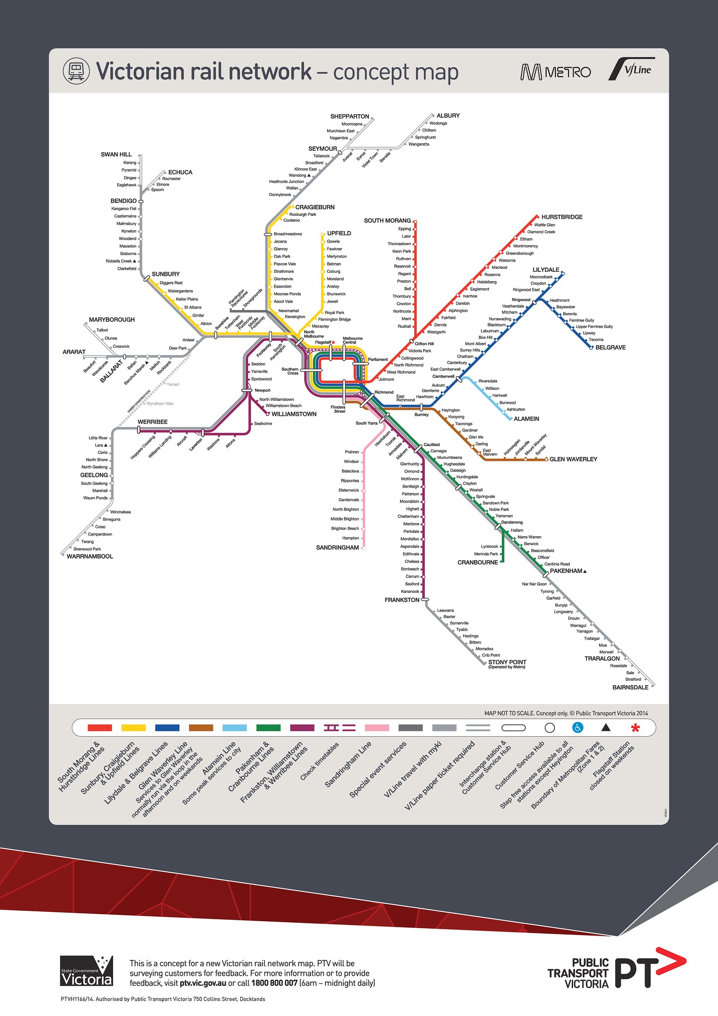
The rail network - 16 lines in total - is split into 4 groups and at Flinders Street (which is the origin/destination of all metropolitan train services), groups of lines have dedicated platforms - so regular users know the general platform they need to go to and just need to check where the train is going on all the PIDs on platforms.

Example: the Caulfield group consists of the Pakenham, Cranbourne and Frankston Lines (Sandringham used to be part of it (well still technically is) but it's now operationally separate and has dedicated platforms at Flinders Street) and as a Frankston train arrives at Flinders Street, it might then become a Pakenham or Cranbourne service or vice versa or it might become a "short stop" service (i.e have a destination which is on the Frankston Line but run the stopping all stations services rather than express service) etc.

Likewise with trams - even though there are only two tracks - on Swanston St which is the world's busiest tram line, there are 8-9 different routes running on it, most terminate in the inner north at Melbourne University and then turn back and head out to the south and east again. Like rail, certain routes are grouped and therefore share common vehicles and trams can go into the Melbourne Uni shunt as one route and then start the reverse journey as another.

I have a feeling that this is becoming less and less common on trams as routes are dedicated fleets (i.e larger trams for routes which carry more people) but they're sharing tracks in the city segments, eg. Elizabeth Street trams: 19 (large 5-section trams), 59 (older B class articulated trams) and 57 (oldest portion of the fleet: single car Z cars).

Even though the trams are well branded with their route (front, rear and on the sides of the trams), regular users are getting to their routes by the tram type.

Doesn't happen much with buses in Melbourne as we don't rely on it in the centre of the city (although some of the DART buses which run along the Eastern Freeway may do it - I'm not sure as I don't use those services at all).

Anyhow, yes it can work quite well, as long as the Passenger Info Display is done correctly - i.e the driver needs to remember to flick it over at the right time.

Rail map for reference - Caulfield is where the Pakenham/Cranbourne/Frankston lines all meet in the inner south east:


Tram map for reference - Swanston St is the big thick block of lines:

Reply With Quote
     
     
  #3  
Old Posted Aug 24, 2015, 3:03 AM
volguus zildrohar's Avatar
volguus zildrohar volguus zildrohar is offline
I Couldn't Tell Anyone
 
Join Date: Apr 2002
Location: The City Of Philadelphia
Posts: 15,988
SEPTA occasionally employs this on its Regional Rail network which was part of the reason for removing the 'R' designations from the routes a couple of years ago. A train that enters Center City from, say, Chestnut Hill West does sometimes leave outbound for Elwyn.

The old map


planphilly.com

The new map


philebrity.com
__________________
je suis phillytrax sur FLICKR, y'all
Reply With Quote
     
     
  #4  
Old Posted Aug 24, 2015, 5:31 AM
scalziand's Avatar
scalziand scalziand is offline
Mortaaaaaaaaar!
 
Join Date: Aug 2007
Location: Naugatuck, CT/Worcester,MA
Posts: 3,506
Happens all the time with the trolleys on the Green line in Boston.
Reply With Quote
     
     
End
 
 
Reply

Go Back   SkyscraperPage Forum > Discussion Forums > Transportation
Forum Jump


Forum Jump


All times are GMT. The time now is 12:39 PM.

     
SkyscraperPage.com - Archive - Privacy Statement - Top

Powered by vBulletin® Version 3.8.7
Copyright ©2000 - 2024, vBulletin Solutions, Inc.