EDIT: My conclusions about the location of Lookout Mountain turned out to be wrong. Lorendoc correctly identifies the actual location later in this thread, at http://forum.skyscraperpage.com/show...89#post6239389.
Of the places and stories that I've researched for this thread, Lookout Mountain has been the most elusive historically, and the hardest to actually find. I'd be embarrassed to admit how many days I've spent studying maps and old photos, and how many times I've driven out to Laurel Canyon to walk the narrow streets, search for landmarks, and try to make sense of the few clues that arose.
I did finally locate the original site of the Inn and will share photos of it, but later. I know this will be a long piece with a lot of images and a few "detours", so I'm going to submit it in 3 or 4 separate posts, which might be spread out over a week or so. I hope that breaking the story up into chapters doesn't make it hard to follow. If the chapters seems unwieldy, I'll compile everything into one giant post at the end, and delete the former ones.
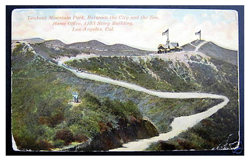
Anyway, this first entry will give an overview of the hills and topography around Lookout Mountain, and a short history of the Inn.
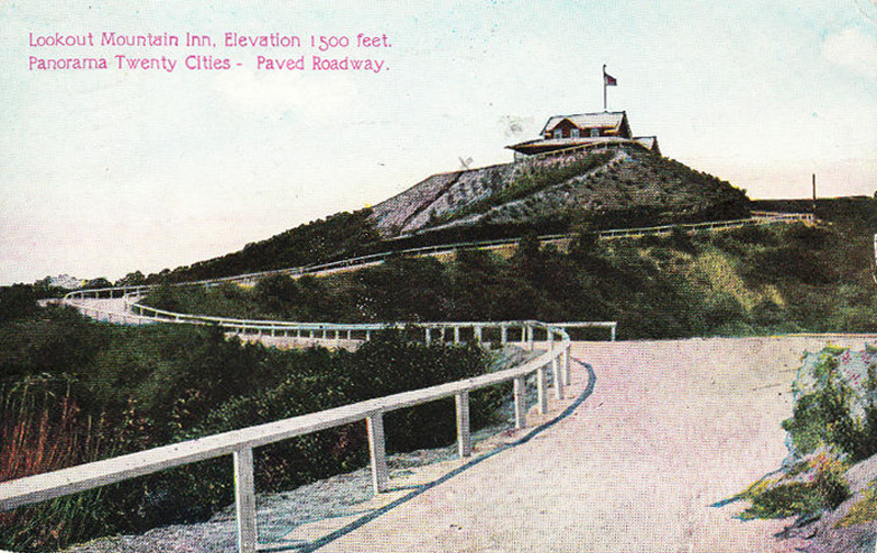
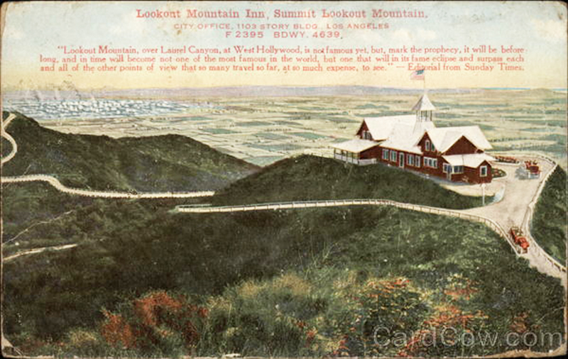
There are several myths that surround this place, starting with its name. In my opinion, Lookout Mountain is not a mountain at all. Facing southeast, it most certainly is a lookout -- a very dramatic one, with jaw dropping views of Hollywood and downtown. And Lookout Mountain does have a summit that's identified with a survey marker. But the Inn was located down slope from the peak, and many nearby spots are higher. I'd guess that the site of the Inn was chosen for it's dramatic drop off -- a picture window facing town would give impressive head to toe 270 degree views of West Hollywood, Hollywood, downtown, Santa Monica, the Pacific, and more.
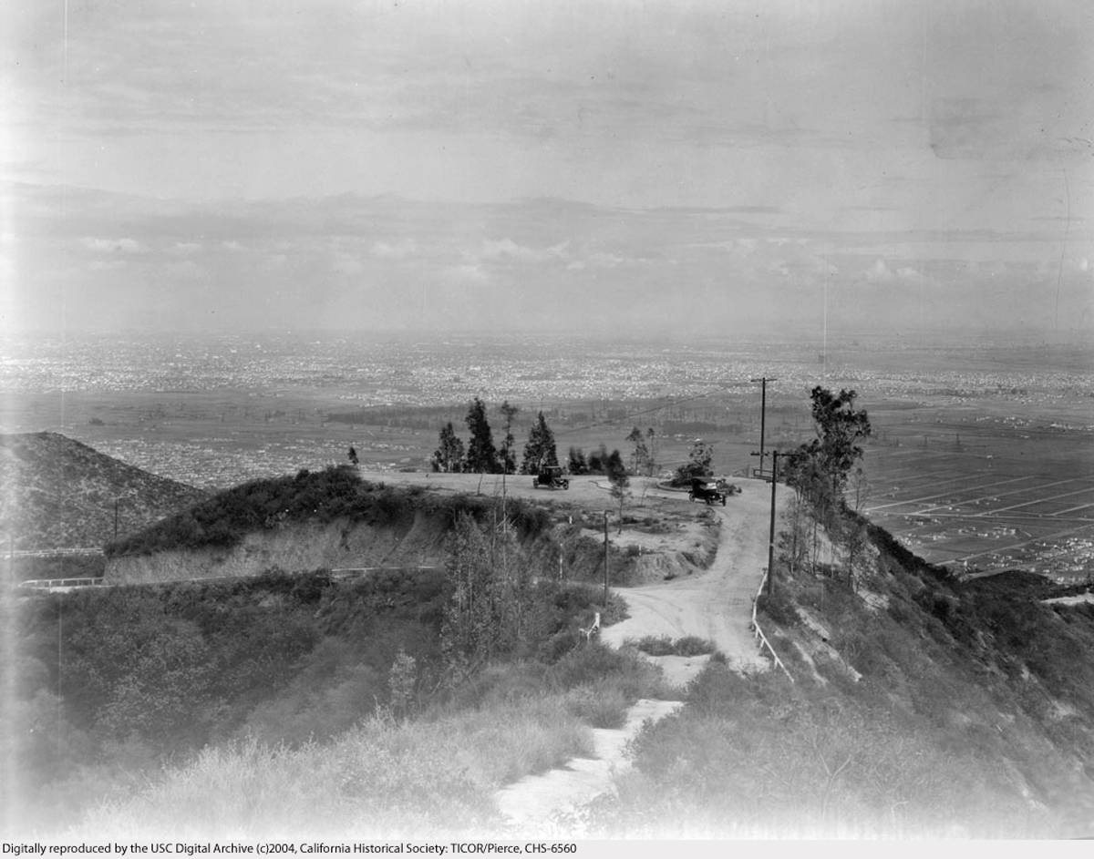
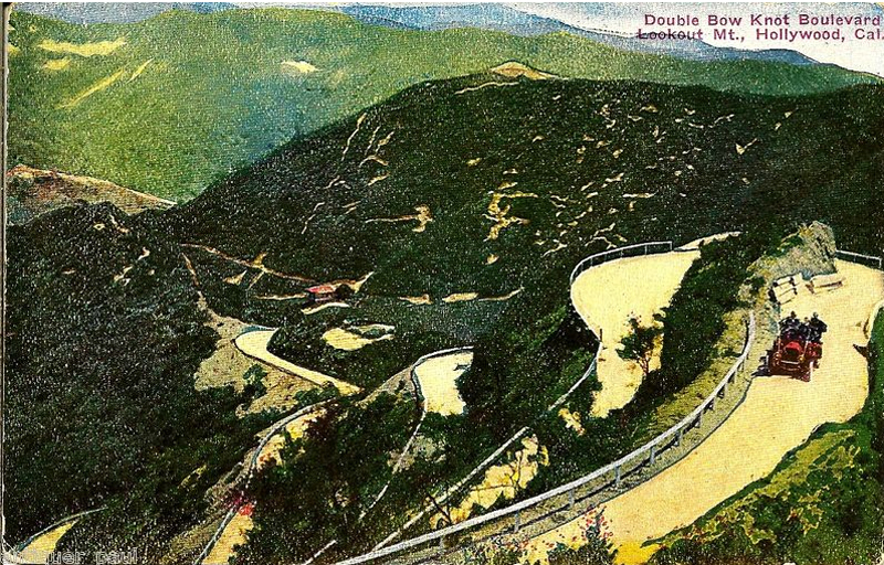
Exploring this area, I was repeatedly struck something I've mentioned here before -- the "vanished views" that result from development if the hills. Looking at old photos of the area, you see that anyone walking or driving around Lookout Mountain would have had nearly unobstructed views in most every direction. In their natural state the hills were mostly bare; there were few trees or man made obstructions. If you went for a walk around the hills and ridge tops up there, you'd easily see much of L.A. and it's environs from almost any spot along the way -- like Griffith Park today. But the Hollywood Hills are are completely transformed, especially this neighborhood. The hills themselves are still there, but development and landscaping have completely changed the features of the area. Homes were built at nearly all the good view spots, which now block the view from the street. Between houses you have privacy walls, trees, and garages. I don't mean to complain, and I would love to live in one of those homes some day. I'm just startled by the way that development in this area has erased nearly all the street views. Walking along the streets of Lookout Mountain can be a weird experience You're wedged between vertical elements, as if you were in twisting corridor with high walls. I suppose it is like the "canyonization" effect that large buildings have upon cities -- you can be a few blocks the Empire State Building in Manhattan, but unable to see it at all. Later on I'll post some then and now shots that will show the changes clearly.
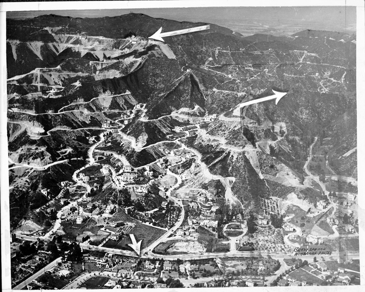
Photo-wise, I'll start with two shots that puts the area in perspective quite nicely. In the first, is a 1927 aerial, Sunset Blvd. is at the bottom. The Lookout Inn had been destroyed in a fire 9 years earlier, but if you look closely, you can see the hilltop home at 8782 Appian Way, above the site of the Inn. The lower slope of the mountain is flanked by Queens Road on the left, and Kings Road on the right.
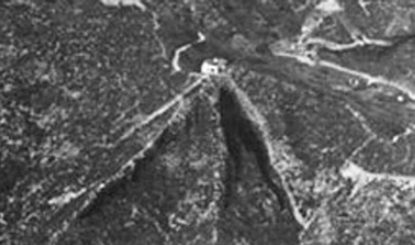
I've added an enlargement beneath it, to help you spot the home. This unusual custom home was built for Chet Crank, a local advertising executive. It was not the first home in the Lookout Mountain area but cost $30,000 to build and was fairly extravagant for its time. The home had a central tower featuring a huge central wrought iron staircase. The interior doors were arranged in groups of three with "each door painted a different color to preclude monotony". (Since the home was built the same year that this photo was taken, it may be unfinished in this shot.) The little dirt road that forms a loop above and to the left of the home is Appian Way.
The terraced roads above Sunset are Harold Way, Carlton Way, Hollywood Blvd. (which, I was surprised to learn, crosses Laurel canyon Blvd. and continues northwest for about 2 more miles), and Franklin St. Laurel Canyon is outside of the image, several blocks to the right. (Ignore the large arrows, they refer to something else.)
 http://digitallibrary.usc.edu/search...ller/index.htm
Now, several web sites state that this home occupies the original Lookout Inn site, but that is not true! Fantastic house, but wrong location...as I will explain later.
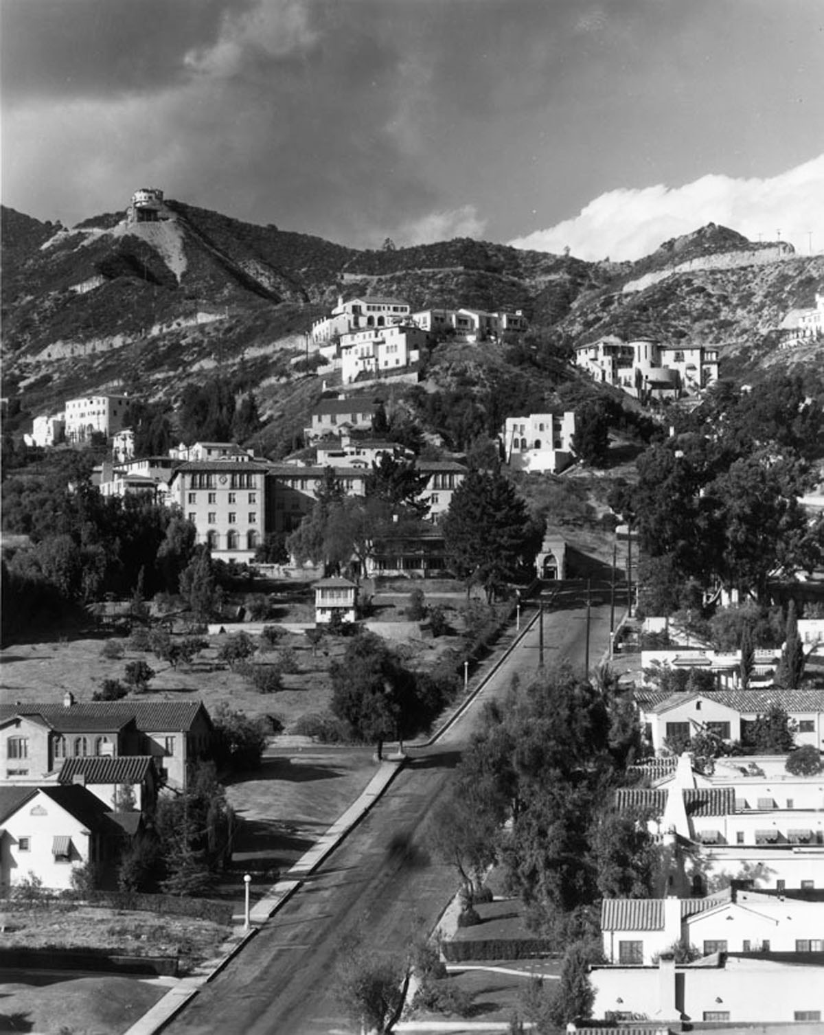
Here's another USC photo that shows the Chet Crank home more clearly. The steep street in the foreground is Kings Road. (Kings is one of the very oldest streets in L.A. A few months ago I posted about Tiburcio Vasquez, a bandit who was captured at the home of "Greek George", at Kings and Santa Monica Blvd. in 1874.) Neither Kings or Queens Roads ever reached the summit. Lookout could not be accessed from Sunset until Holly Vista Drive, later named Sunset Plaza, was built in 1925.
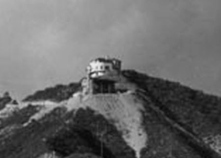
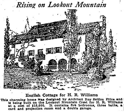
If you look super closely, you'll what looks like see another building beneath 8782 Appian. That one might be El Nido, a girl's camp that opened in 1928. Or it might this English cottage, which was built in 1925. Or it might be something entirely different.
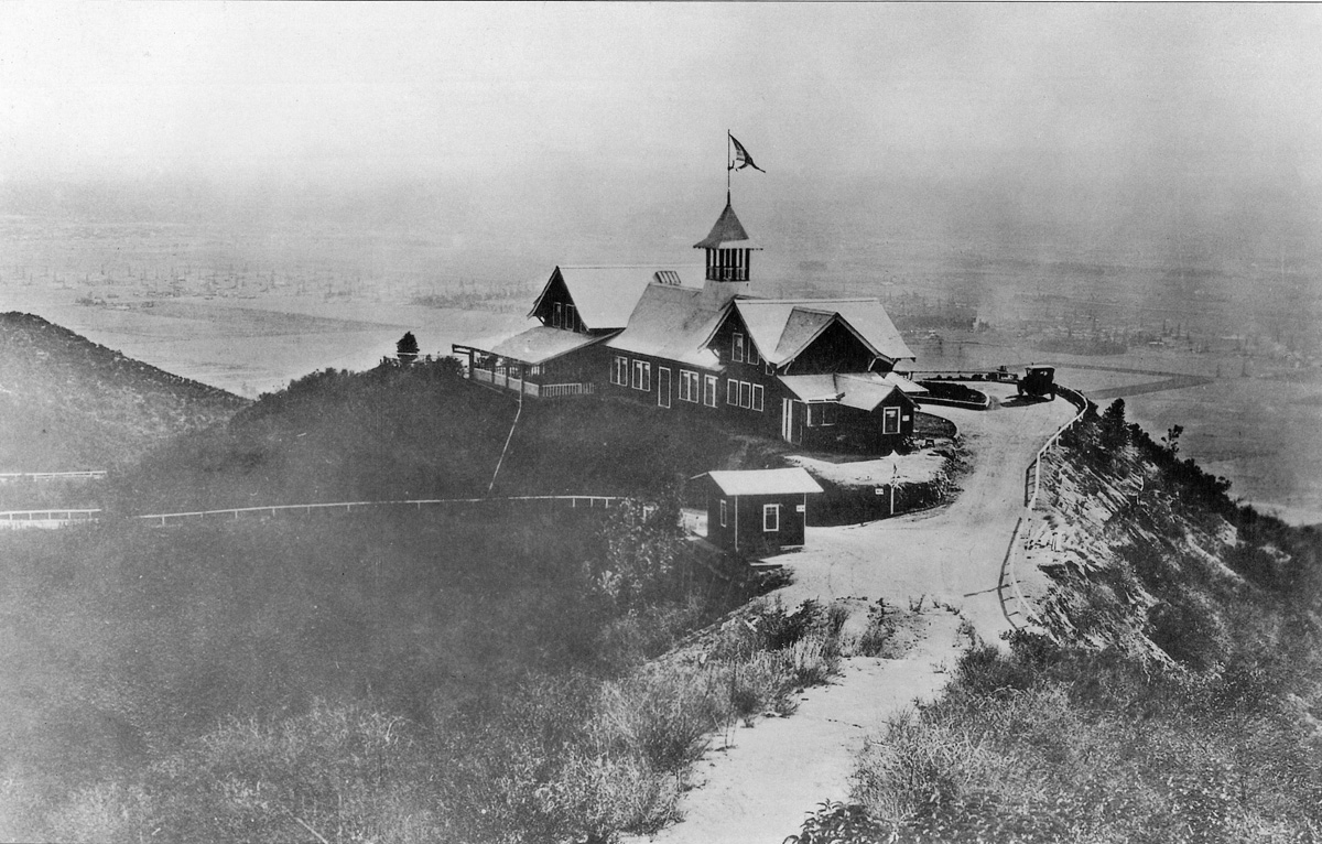
OK, now it's time for some pictures of the place itself. I haven't found anything definitive on its opening date, but I think it was about 1915. It was designed by Alfred F. Priest for the Canyon Castle Corp., Charles Mann and Sam Porter. The building was U shaped, with a large ballroom, card and billiard rooms, banquet and dining halls, a ladies parlor, and 70 upstairs guest rooms, all with private bathrooms. The interior finish was Oregon pine and white enamel with mahogany doors. It had two passenger elevators, steam heat, plumbing, electric wiring, and ice and refrigeration plant, and vacuum cleaning system. There were plans for a stable, tennis courts, and golf links, but I don't know if they were ever completed. Construction cost was about $90,000.
(Note: the founder of the original Laurel Canyon real estate office at Kirkwood and Laurel Canyon Bl. was another gentleman named Charles Mann. By a strange coincidence, these two early developers of the Canyon had the same name, though they were not related.)
Here's the site just before the Inn was built. As you can see, the location with its fantastic view was an auto tour destination. USC dates this photo 1914 -- if true, that would mean that the Inn was open for less than 4 years.
 http://digitallibrary.usc.edu/assets...59445ED07?v=hr
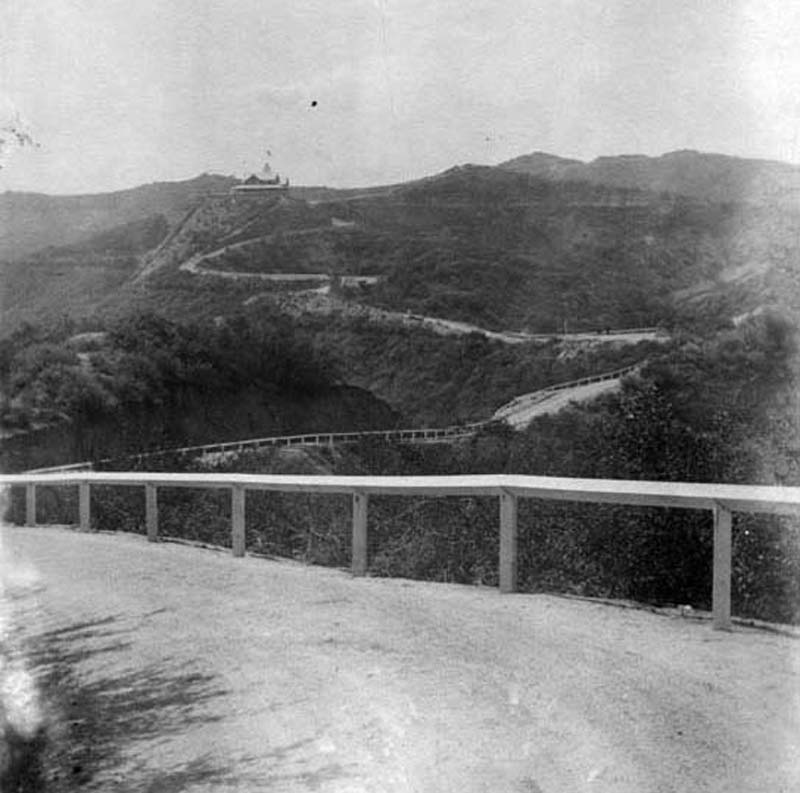
Another old photo, taken from the exact same spot, after the Inn was built. Of course, both of these views are from the opposite direction, compared to the aerial shots. Hollywood is at about 10 o'clock, downtown (which you can't really see) is at about 12 or 1 o'clock. By the way, do you see what I mean about the unencumbered views? Clearly, you could wander around these hills in 1910 and see all around, from any high point. It isn't like that now!

(From Hollywood Then and Now by George Jezek)
TO BE CONTINUED


 Prev
Prev


 Google
 Google


 Google
 Google


 Linear Mode
