Quote:
Originally Posted by animatedmartian

Your theory is almost right. Though don't forget that downtown and nearby ghettos were also populated with other immigrants who would be classified as white.
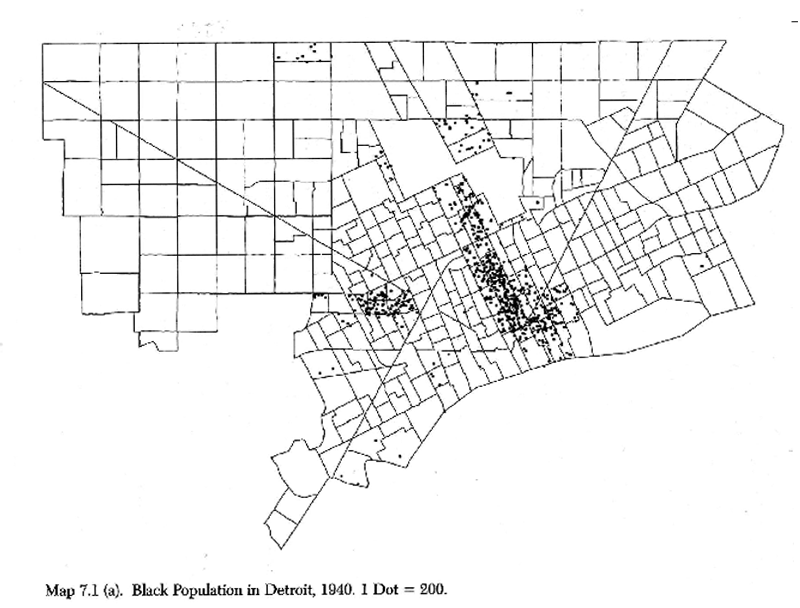 http://detroitography.com/2013/11/15...ion-1940-1970/
For example, notice that Jews seem to move faster and farther out. By 1940, Jews had already made it to 8 Mile while blacks were still pretty limited to downtown.
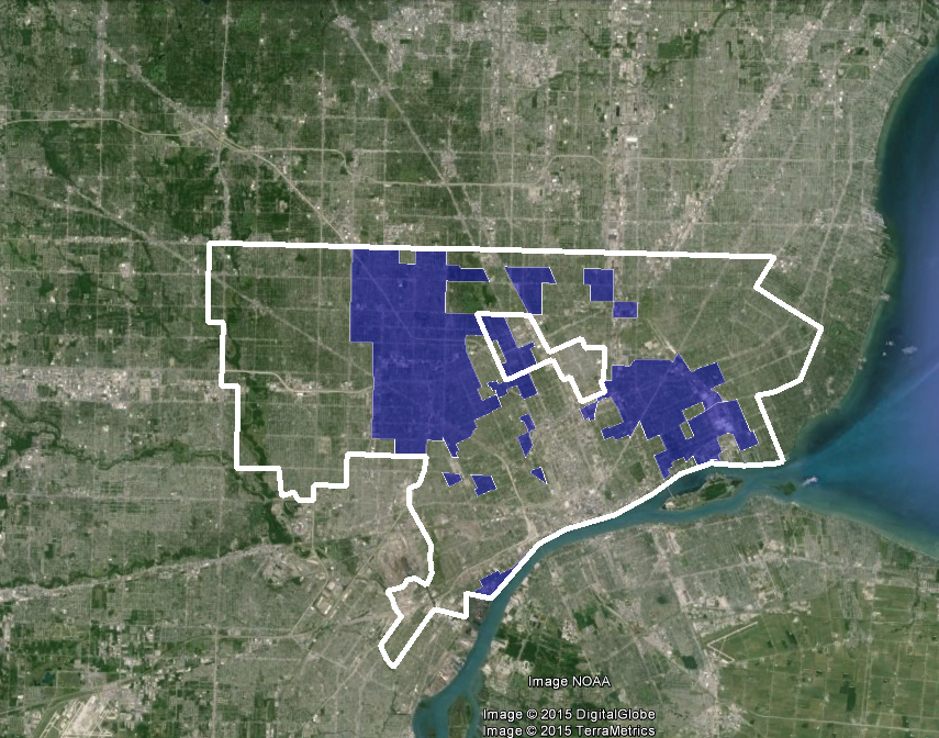
 http://detroitography.com/2014/06/30...oit-1840-1965/
You could pretty much infer that white-flight almost began just as soon as Detroit reached prosperity through its industrial revolution. I don't think it was so much a change in household sizes as it was extreme housing segregation and racist practices. Banks wouldn't lend to homeowners that lived in an area with any number of blacks which made it hard for whites to stay in one area even if that particular white family was not racist themselves.
I'd suspect many other Midwestern and possibly Los Angeles might have gone through a similar pattern. |
I'm not too sure what you're trying to argue.
My argument is basically you had a few different rings in which different things were happening, and those rings have been expanding outwards with time.
The outermost ring saw new housing development, which was happening in the outlying parts of Detroit in the 40s and 50s and maybe a little bit in the 60s, but since then has shifted into the suburbs.
Then there's a ring where housing unit counts are relatively stable, and where it's still predominantly white, but population was decreasing due to household size decreases.
Then there's the "white flight" ring, which was probably mostly in the inner core in the 40s, and then expanded into Dexter-Linwood in the 50s, and across Livernois in the 60s. Occupied housing units probably didn't really decline yet, but blacks typically had larger household sizes so population often increased a little as this was happening. As for why white flight was happening, some of it could be racism from the residents, some could be the bank loan issue, and maybe you also had residents who realized that problems with bank lending would cause neighbourhoods to decline once blacks started moving in and tried to leave before that happened.
Finally there's the older ghettos, places which were maybe already predominantly black for a couple decades, and where the difficulty in getting loans, low property values, etc caused the neighbourhoods to be in pretty bad shape, so few people moved into them and the blacks living there moved out as soon as they could, and this is where the greatest population declines occurred.
It's true though that I'm generalizing somewhat, there were neighbourhoods in the inner core that weren't predominantly black like Downtown, Cass Corridor and SW Detroit. Some of those still experienced population loss and it would be interesting to know what was happening in those, was it mostly urban renewal and household size changes or was there ever significant abandonment?
And yes, similar things were happening in many midwestern cities, some northeastern cities, and even some sunbelt cities. You had neighbourhoods in Los Angeles, Dallas and Atlanta for example where the racial makeup changed just as fast as in Detroit in the 60s and 70s.


 Linear Mode
