Quote:
Originally Posted by HossC

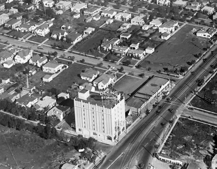
While I was looking for pictures of La Rue earlier, I came across this 1928 aerial shot of the Bekins Storage building on Santa Monica Boulevard, and there are the stores on the right.
 hollywoodphotographs.com
 |
Quote:
Originally Posted by Martin Pal
This is a fantastic photo!
I love seeing the Red Car tracks along Santa Monica Blvd.
I wish the area across the street from Bekins was a nice park with those trees still there. "La Boheme" Restaurant is on the corner currently.
These photos still amaze me because these streets look flat, but they are all on a rather steep incline leading up to Sunset Blvd. San Francisco steep on the North end. (I know, I walk up and down them quite frequently.)
On Olive Drive, the street alongside Bekins, I wonder what that tower is on the building about four structures up?
If you look at the "Bekins" sign in the photo, above that--is that a line of people going in or coming out of that building? Wonder what it is?
Whether any of these housing structures still exist, I don't know, but I do know all those spacious front yards are occupied by apartment buildings!
In the top righthand corner of this photo is a structure with a yard facing the street. The address is 1108 N. Flores St. It's the site of a Tex Mex restaurant named Marix. I am going there this evening for a 50th birthday dinner for a friend and I will surely be thinking of this photograph as I walk to the destination in a few hours.
|
That restaurant and the buildings on either side are nearly the only survivors from the old photo -
if those are original structures underneath remodeling. Los Angeles GISNET indicates that they are - it says 1922 for the restaurant building, 1924 for the house next door, and 1927 for the commercial building facing Santa Monica Blvd. of which we can see just a tiny corner in the old photo.
Aside from these, and the Bekins building and storefronts discussed earlier, there is one more survivor, in the very bottom right corner. This is at 1040 N. Croft, behind a house at 1036 N. Croft. You can just make out the tiled roof and arched front opening of a second-story entrance, which is just as it looks today. It was built in 1923 according to GISNET.
There were a couple of holdouts side-by-side on the east side of Kings Road until very recently (after 2011). 45-degree Google Maps aerials show them, but the more recent straight-down picture shows a big building under construction. I think the southernmost of those two houses is at the edge of the old photo - you can see most of the house and a detached garage in back. For the second house all you can see in the old photo is the rear detached garage.
There is one more house still on Kings Road - west side, closer to Santa Monica blvd. - but I think it is still an empty lot in the old photo. GISNET says it was built in 1935.