Quote:
Originally Posted by HossC

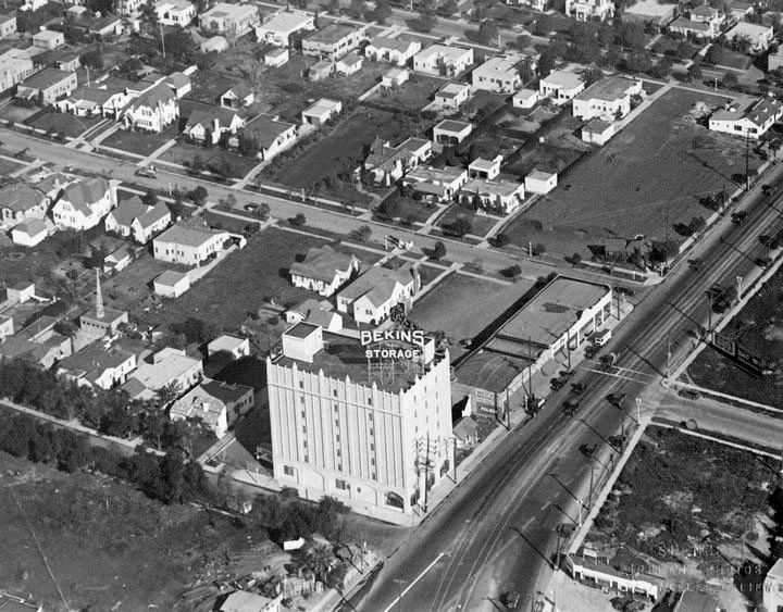
While I was looking for pictures of La Rue earlier, I came across this 1928 aerial shot of the Bekins Storage building on Santa Monica Boulevard, and there are the stores on the right.
 hollywoodphotographs.com
 |
This is a fantastic photo!
I love seeing the Red Car tracks along Santa Monica Blvd.
I wish the area across the street from Bekins was a nice park with those trees still there. "La Boheme" Restaurant is on the corner currently.
These photos still amaze me because these streets look flat, but they are all on a rather steep incline leading up to Sunset Blvd. San Francisco steep on the North end. (I know, I walk up and down them quite frequently.)
On Olive Drive, the street alongside Bekins, I wonder what that tower is on the building about four structures up?
If you look at the "Bekins" sign in the photo, above that--is that a line of people going in or coming out of that building? Wonder what it is?
Whether any of these housing structures still exist, I don't know, but I do know all those spacious front yards are occupied by apartment buildings!
In the top righthand corner of this photo is a structure with a yard facing the street. The address is 1108 N. Flores St. It's the site of a Tex Mex restaurant named Marix. I am going there this evening for a 50th birthday dinner for a friend and I will surely be thinking of this photograph as I walk to the destination in a few hours.